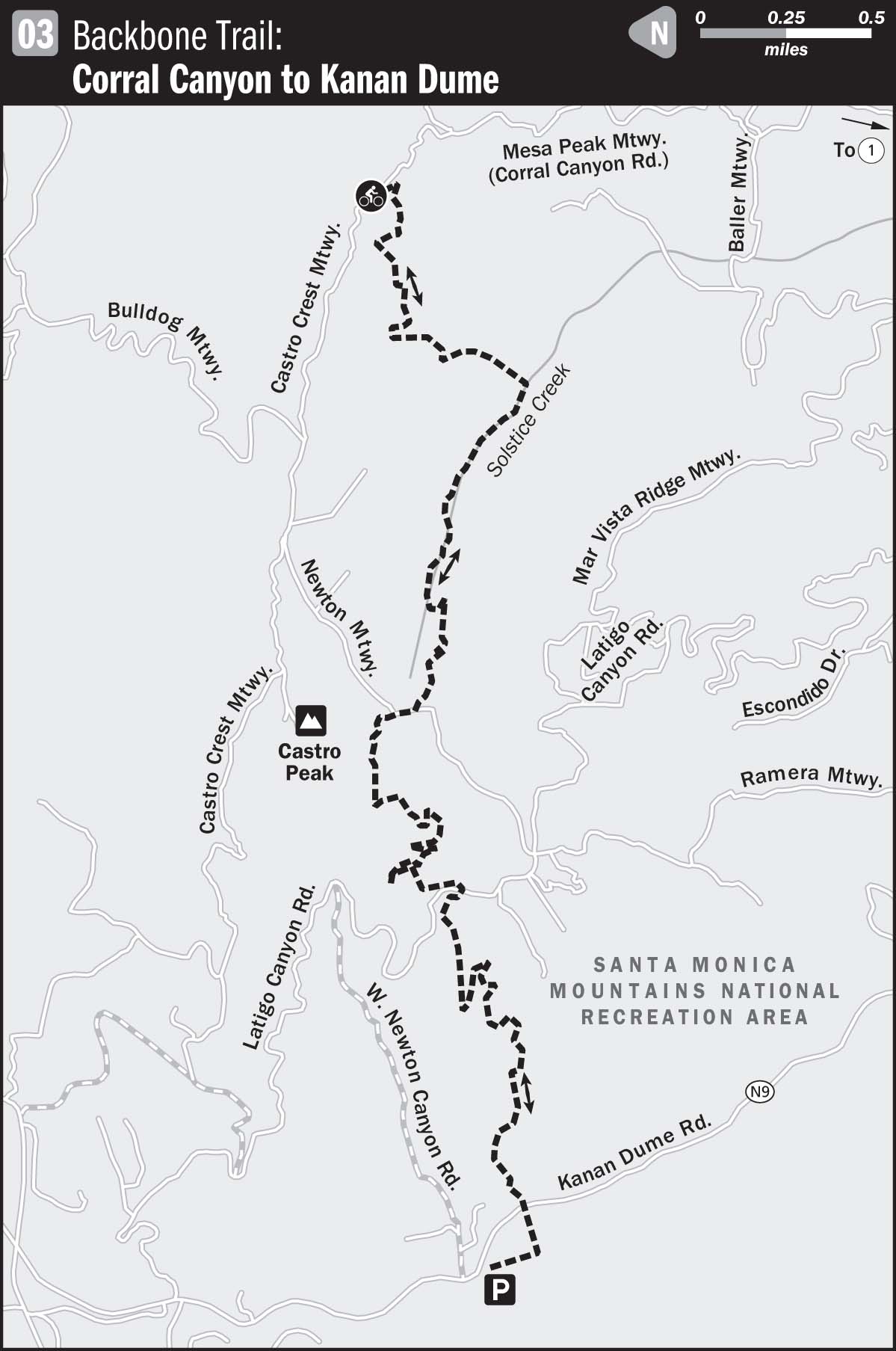
03 BACKBONE TRAIL: CORRAL CANYON TO KANAN DUME
KEY AT-A-GLANCE INFORMATION
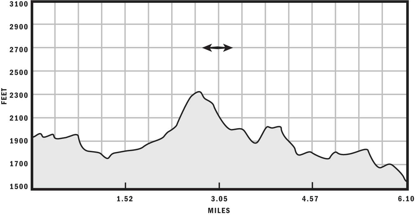
Length: 12.2 Miles
Configuration: Out-and-back
Aerobic difficulty: 4
Technical difficulty: 4
Scenery: Pacific Ocean, Santa Monica Mountains, Castro Peak
Exposure: 80% sunny, shady in creek area
Trail traffic: Light–moderate on weekdays, moderate on weekends
Trail surface: 100% singletrack; varies from loose and dry to hard-packed and loamy
Riding time: 2–3 hours
Access: Sunrise–sunset, 7 days a week
Maps: USGS 7.5-minute quad: Point Dume
Special comments: It can be very hot on this ride, so bring plenty of water and use sunblock.
GPS TRAILHEAD COORDINATES (WGS84)
UTM Zone 11S
Easting 337742
Northing 3772637
Latitude N 34.05′55″
Longitude W 118.45′31″
DIRECTIONS
From CA 1 (Pacific Coast Highway), take Corral Canyon Road for 5.4 miles until it terminates in a parking lot. The trailhead is in the southwest end of the small parking lot.
In Brief
Thanks to advocacy groups like the Concerned Off-Road Bicyclists Association and the International Mountain Bicycling Association, the Backbone Trail is still open to mountain bikers. This section of Backbone is cherished by many as the best singletrack action in the Santa Monica Mountains. If you had only one day to ride in Los Angeles, this would be the place to go. This section of Backbone has everything—challenging climbs, tricky switchbacks, technical creek crossings and shaded, loamy stretches that look as if they were taken right out of your favorite mountain bike magazine.
Description
Although there are a variety of staging options for this ride, the Corral Canyon entrance provides a gradual climb as a warm-up, rather than the very laborious grind (from the Kanan Dume Road entrance at the other end of this route) that will turn your cold legs into Jell-O. Staging from Corral Canyon also saves the most fun for the descent at the end of the ride, which is a theme of the recommended routes in this book.
Two trails are accessible from the Corral Canyon parking lot. One is a fire road called Castro Crest Motorway that leads to Castro Peak. Although at one time this was a scenic option that could be incorporated into the Backbone experience, the connecting fire road called Newton Motorway has since been gated off by the owner of the radio-tower facility and private residence at the summit. If you ride up this hill, you won’t be able to reconnect with Backbone. Fortunately, land disputes have so far spared the Backbone Trail. Its entrance is clearly marked in the western end of the parking area.
The Backbone starts with an easy descent, followed by some light climbing and flat sections. This recently scorched section, although certified singletrack, doesn’t do justice to the rest of the ride, which just gets better and better. After about 0.7 miles, you’ll descend into the upper reaches of Solstice Canyon, where you’ll encounter a few moderately difficult creek crossings.
After your last dab-free crossing of Solstice Creek, shift into the granny gear and get ready for the longest sustained climb of the day. You will ascend nearly 500 feet over the next 0.75 miles, so pace yourself and ponder the meaning of life while you pedal this grinder, gracefully conquering its moderately challenging switchbacks.
At roughly 2.5 miles from your car, cross Newton Motorway and rejoin the Backbone Trail. The next quarter mile has minimal elevation change, but only adept technical riders can ride it dab-free because of some rocky areas with hidden lines of Da Vinci Code stature. The next order of business is a steep, winding half-mile descent that you will enjoy a lot more if you don’t think about how painful it will be to climb up the other side. At the bottom of this section, cross a creek and see an old, rusty motor scooter made some time ago by a Spanish company called Derbi. If you’re completely pooped at this point and have fantasies about ditching your rig and motoring out on this European bad boy, don’t bother—the scooter has long since ceased running and now serves as a landmark on this trail.
Cross another staging option when you ride into a parking lot about 4 miles in, after which you’ll cross Latigo Canyon Road and continue riding the Backbone. After another grin-inspiring half-mile descent, you’ll encounter a rare treat in Southern California—a 0.9-mile stretch with several small climbs and descents, rather than an extreme example of one or the other. At approximately 5.7 miles in, cross a paved private road and 0.2 miles later descend a very steep section of trail into Santa Monica Mountains Conservancy parking lot at Kanan Dume Road. You’ll turn around and start backtracking here, but don’t take your siesta yet—you’ll need warm legs to grind up that horrendously steep hill you just floated down.
Out-and-backs usually recycle previously ridden terrain. But this part of the Backbone has so many subtleties and technical treats that riding it eastward back to your car is an entirely new, exciting experience. At 12.2 miles you’ll be done, thoroughly intoxicated with joy and wishing you brought your night-light so you could do it all over again.
After the Ride
Virtually every international flavor of cuisine can be found on Pacific Coast Highway as you head back to Los Angeles. Cholada Thai Beach Cuisine at 18763 Pacific Coast Highway offers fiery fare as well as cold bottled Thai macrobrews to wash it down; (310) 317-0025. For American food, a full bar, and possibly a musical display from forgotten bands of the 80s, visit The Malibu Inn located across from the historical Malibu Pier at 22969 Pacific Coast Highway; (310) 456-6060.