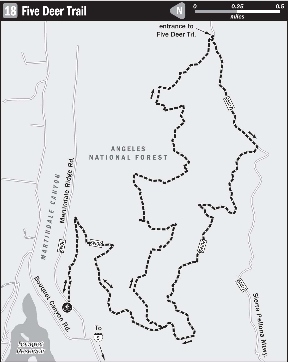
18 FIVE DEER TRAIL
KEY AT-A-GLANCE INFORMATION
Length: 11 miles
Configuration: Loop
Technical difficulty: 3
Aerobic difficulty: 3
Scenery: Bouquet Reservoir, Bouquet Canyon, Martindale Canyon, Sierra Pelona Mountains, Sleepy Valley
Exposure: 70% exposed to sunshine
Trail traffic: Light–moderate on weekdays, moderate on weekends
Trail surface: Dry hardpack with embedded and loose rocks
Riding time: 1.5–2.5 hours
Access: Sunrise–sunset, 7 days a week
Maps: USGS 7.5-minute quad: Sleepy Valley
Special comments: A Forest Adventure Pass must be purchased for each vehicle parked. These can be purchased for $5 from various private vendors and ranger stations listed at www.fs.fed.us/r5/sanbernardino/ap/welcome.shtml.
GPS TRAILHEAD COORDINATES (WGS84)
UTM Zone 11S
Easting 374802
Northing 3827391
Latitude N 34.34′50″
Longitude W 118.21′54″
DIRECTIONS
From Los Angeles, take I-405 northbound toward Sacramento, and then converge with I-5 northbound. Continue on I-5 about 3 miles, merge with CA 14 north toward Lancaster-Palmdale 8.5 miles, and exit CA 14 at Sand Canyon Road. Turn left and drive on Sand Canyon Road about 2 miles until you reach Sierra Highway; go right. Stay on Sierra Highway about 0.4 miles, and then turn left onto Vasquez Canyon Road. Continue on Vasquez about 3.5 miles until you reach Bouquet Canyon Road; then turn right. After roughly 9.7 miles on Bouquet Canyon Road, look for the Bouquet Canyon Dam and the Bouquet Canyon Reservoir. About 1 mile beyond where the road passes the dam on your left, turn right onto a dirt road marked 6N08. About 0.5 miles up this dirt road, another dirt road, marked 6N06, intersects it. Park at the intersection, being sure to display your Forest Adventure Pass.
In Brief
The Five Deer Trail is a surprisingly pristine singletrack within the highly popular off-highway-vehicle (OHV) area called Rowher Flats. Although there are many great trails located within OHV areas in SoCal, none have lighter OHV traffic than Five Deer Trail because of its elusive location and sliver width. Even if you do find yourself dodging a few dirt bikes, you’d be hard-pressed to find a better piece of singletrack anywhere in the vicinity of LA County.
Description
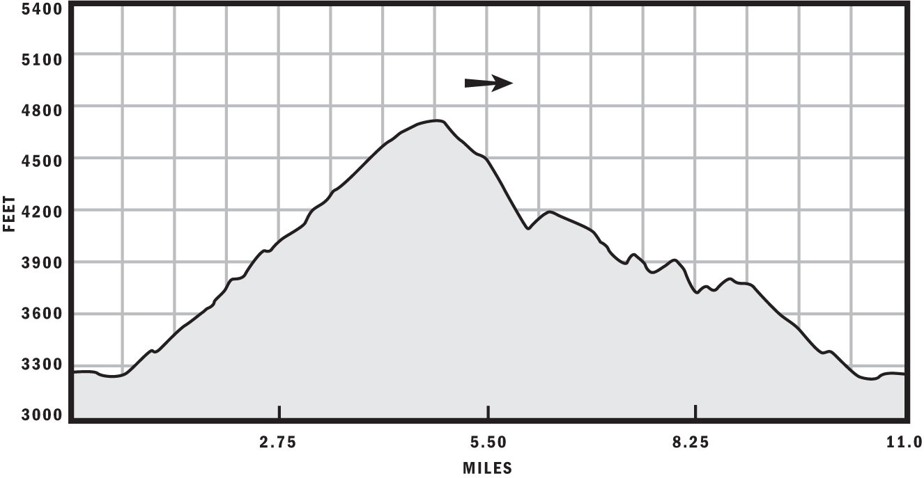
Park your rig, hang your Forest Adventure Pass, hop on your cycle, and start spinning east on Forest Service Road 6N08. Like most service roads, the elevation gain is steady and mellow. As you rise up the road, lots of great scenery will come into view—the Bouquet Reservoir, Jupiter Mountain, Martindale Canyon, and Leona Valley, to name a few. Relax and enjoy the leisurely 4.8-mile climb with a paltry 1,500-foot elevation gain.

Vista behind mountain bike wheel
You won’t find any navigational mishaps on your way to the summit; just stay on the wide, groomed road and avoid the rutty, steep Jeep road that periodically intersects it. At the 4.4-mile mark, sit down and enjoy another majestic panorama of the surrounding mountains and valleys, including Mount McDill, Sierra Pelona Valley, and Soledad Canyon.
After your break, cross over the fence and start descending FS 6N07, which is easy to spot because it’s the only option available. Look for the entrance to Five Deer Trail, which is on the left side of FS 6N07, about 0.9 miles from the cancellation of FS 6N08, and roughly 5.3 miles from the start of the route. It’s the only singletrack that descends to the west.
The first mile of Five Deer Trail is very steep and marred with deep ruts that present a technical challenge. To avoid mishap, repeat these words to yourself over and over: “Look where I want to go, not where I don’t want to go.” Sounds silly, but it works. For some reason, the hands respond involuntarily to visual input. You will turn where you look; remember that.
The grade mellows out shortly, and Five Deer becomes what you came for—a snaking, narrow, peaceful, pristine singletrack not unlike the trails pictured in every mountain bike mag. You can thank the dirt bikers for keeping this trail passable. Without their visits, the trail would be so overgrown that you’d have to crawl through almost impenetrably dense foliage on your hands and knees.
After crossing a few Jeep roads, you’ll sadly find the singletrack comes to an end at the 9-mile mark, after which you’ll turn right and retrace your tracks to your vehicle. If you have a dirt bike, come back another day and give Five Deer a shot using petrol instead of carbohydrates—and do it quick, because dirt bikes are very close to being outlawed on all public lands in California.