21 STRAWBERRY PEAK LOOP
KEY AT-A-GLANCE INFORMATION
Length: 14.8 miles
Configuration: Loop
Technical difficulty: 4
Aerobic difficulty: 4
Scenery: Strawberry Peak, Josephine Peak, Mount Lawlor, San Gabriel Mountains
Exposure: 50% exposed to sun
Trail traffic: Light on weekdays, light to moderate on weekends
Trail surface: Mostly loose and rocky, with some sandy and loamy sections—95% singletrack
Riding time: 2.5–3.5 hours
Access: Sunrise–sunset, 7 days
Maps: USGS 7.5-minute topo: Condor Peak, Chilao Flat
Special comments: To park your vehicle in this area, you must display a Forest Adventure Pass on your car. These can be purchased for $5 from various private vendors and ranger stations listed at www.fs.fed.us/r5/sanbernardino/ap/welcome.shtml.
GPS TRAILHEAD COORDINATES (WGS84)
UTM Zone 11S
Easting 393883
Northing 3792738
Latitude N 34.16′16″
Longitude W 118.09′12″
DIRECTIONS
From Los Angeles, take I-110 north toward Pasadena until you reach the I-5 exit; head north on I-5 1.9 miles toward Sacramento, then head north on CA 2 toward Glendale about 7.6 miles, then take I-210 east toward Pasadena briefly, and, finally, go north on CA 2, the Angeles Crest Highway, about 9.7 miles. Keep an eye out for Switzer Picnic Area, and park in the lot at the top of the driveway that heads down to it. Don’t forget to hang a Forest Adventure Pass from your rearview mirror.


In Brief
The Strawberry Peak Loop is another reason the San Gabriel Mountains rank as the premier mountain bike destination in Southern California. Although it’s very sketchy, this route doesn’t get top honors in the technical department, but it is without a doubt the scariest. Can you handle riding on the edge of a cliff for extended periods? If you’re affected by vertigo, then ride somewhere else—anywhere else—because you won’t find a more exposed ride in the southern half of the Golden State. It is also one of the best singletrack experiences to be had anywhere, and surely one to write home about.
Safety Message
Because of the trail’s technical difficulty and nearness to disastrous drop-offs and cliffs, no novice riders should attempt this ride under any circumstances. Never attempt this route alone or late in the day.
Description
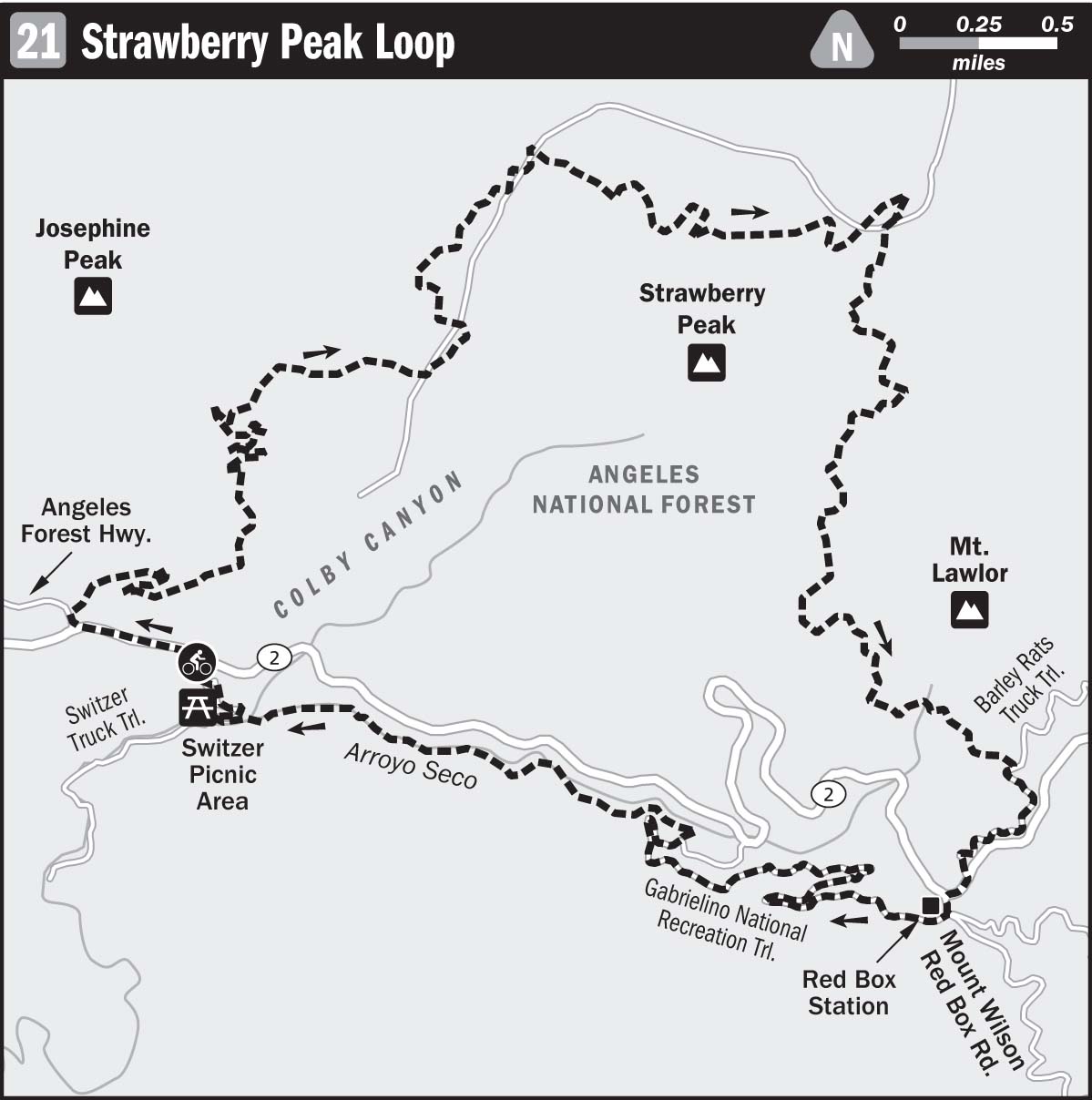
The underlying philosophy behind the design of the routes in this book is to save the technical riding for the descent rather than the climb. After all, we’re not riding unsuspended rigid mountain bikes, looking for the smoothest way down the hill. So park your car at the top of the Switzer Picnic Area driveway, mount up, and ride your rig west about 0.4 miles; then turn right onto Angeles Forest Highway and hang another right onto the first dirt road that comes into view, about 400 feet along.

Taking it all in at Strawberry Peak
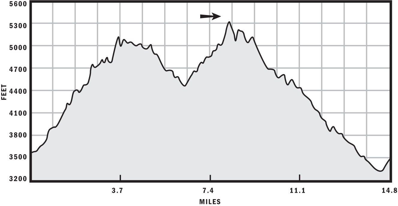
Although on paper the climb to Josephine Peak seems like a lung burner, it’s the mellowest 3-mile, 1,350- foot climb to be found anywhere. The fire road never gets really steep, and its smoothness allows the rider to easily reach a meditative state in the saddle. Before you know it, you’ll be crossing Josephine Saddle, which is the ridge that connects Josephine Peak to Strawberry Peak. Now you’re riding singletrack, and you won’t see another fire road for the rest of the day.
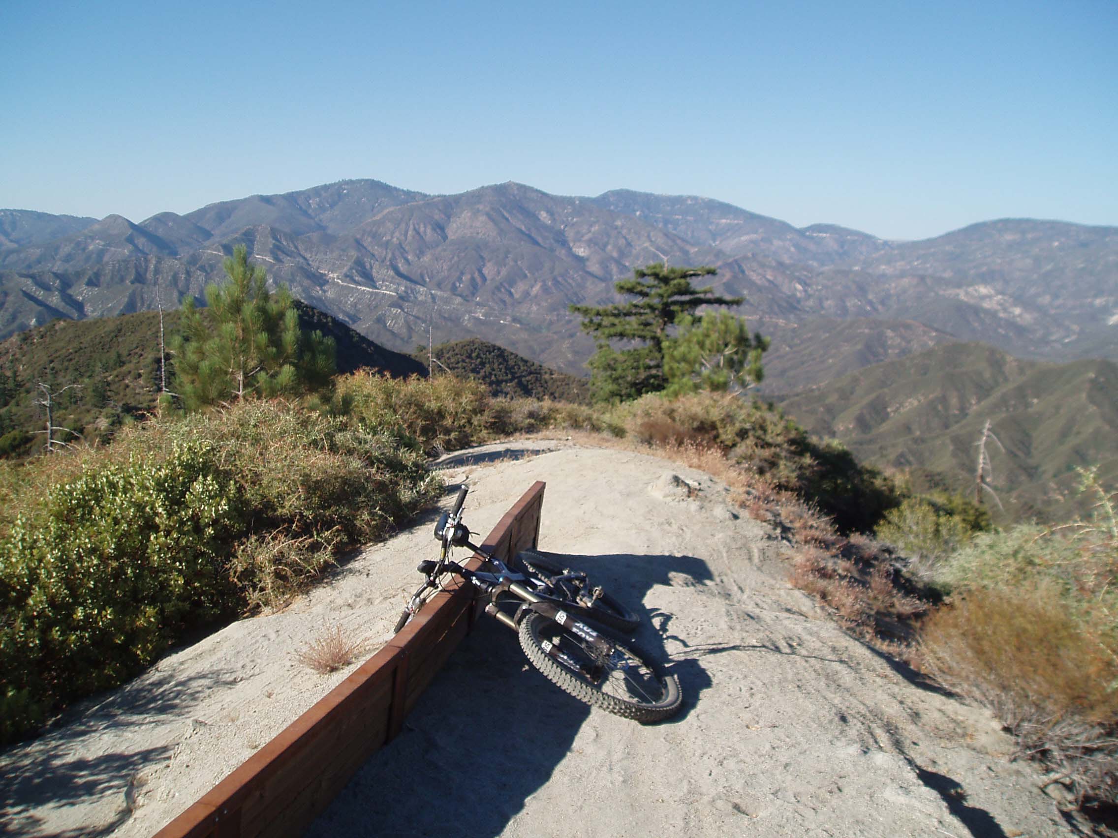
After roughly 3.4 miles, you’ll see the turnoff for Colby Canyon Trail. Stay left and save that adventure for another day. For roughly the next 1.7 miles, the trail skirts the north side of Strawberry Peak. This part of the ride is the scariest because much of the trail is constructed on what would be rockslides. Take a minute to appreciate the efforts of whoever built and maintains this trail. The wood reinforcement is there for a reason—without it, the trail would slide down the hill—just like you will if you get too cute with your front tire. Don’t fall in this section. If you do, you may not die, but you are assured at least one night’s stay in the boondocks with plenty of scrapes and lacerations to keep a nice aroma of blood in the air.
The farther you go on Strawberry Peak Trail, the fewer reminders you will see of the fact that you are very close to the urban metropolis of Los Angeles. You may as well be in the Swiss Alps or the Andes Mountains, because you are in an alpine environment with no sign of civilization in sight. At roughly 5.2 miles from the start, a dandy descent will start, finishing about 6.3 miles down the trail; plenty of hunks of granite and sharp, steep turns along the way will keep you on your toes.
A navigational mishap to avoid: turning left at the trail junction at about 6.35 miles from the start. Don’t do this—your objective is to go around Strawberry Peak clockwise. Go right and start the 1.75-mile-or-so climb to the next trail junction at the base of Mount Lawlor. Once you pass this and start your descent of Strawberry Peak Trail to the Red Box Station, you should be pretty bushed because your legs have taken you up more than 3,000 feet. Don’t worry; it’s basically all downhill from this point, but keep your fingers on the brake levers! Just around every corner on Strawberry Peak Trail lies a potential disaster.
After jumping the water bars on your approach to the Angeles Crest Highway, hang a right onto CA 2, make an immediate left onto Mount Wilson Road, and quickly turn right into the parking lot of Red Box Station. Follow the signs in the west end of the parking lot to the Gabrielino National Recreation Trail (NRT). The next 4.2 miles of this route are used more than Strawberry Peak Trail is, so the trail is wider. You may be relieved that you can lay off the brakes for a little while and let it all hang out, but that feeling will be short-lived. The Yucca whipplei, or chaparral yucca, with daggerlike leaves around its base, will keep you from getting imprecise with your steering, as will fear of making one of many disastrous cliffside meanderings. Roughly 2 miles down the Gabrielino National Recreation Trail, rock gardens will test your technical abilities and the structural integrity of your wrist bones if you choose to endo like I did.
The ride ends at the Switzer Picnic Area, where you can have your own feast, if you were so daring as to park your mobile vittle-carrier beyond the gates that close at dusk. If you were smart enough to park your car at the top of the driveway, you can have a tailgate party up there and recollect the day’s action and mishaps on one of the greatest trails anywhere.
After the Ride
Beer aficionados and the malnourished should pay a visit to The Stuffed Sandwich at 1145 East Las Tunas Drive in nearby San Gabriel; (626) 285-9161. For those with a larger appetite, try Zeke’s Smokehouse BBQ at 2209 Honolulu Avenue in Montrose; it has a casual atmosphere and serves ridiculously tasty cuisine that will thoroughly alleviate your carbohydrate, protein, and fat deficiencies; (818) 206-8947.