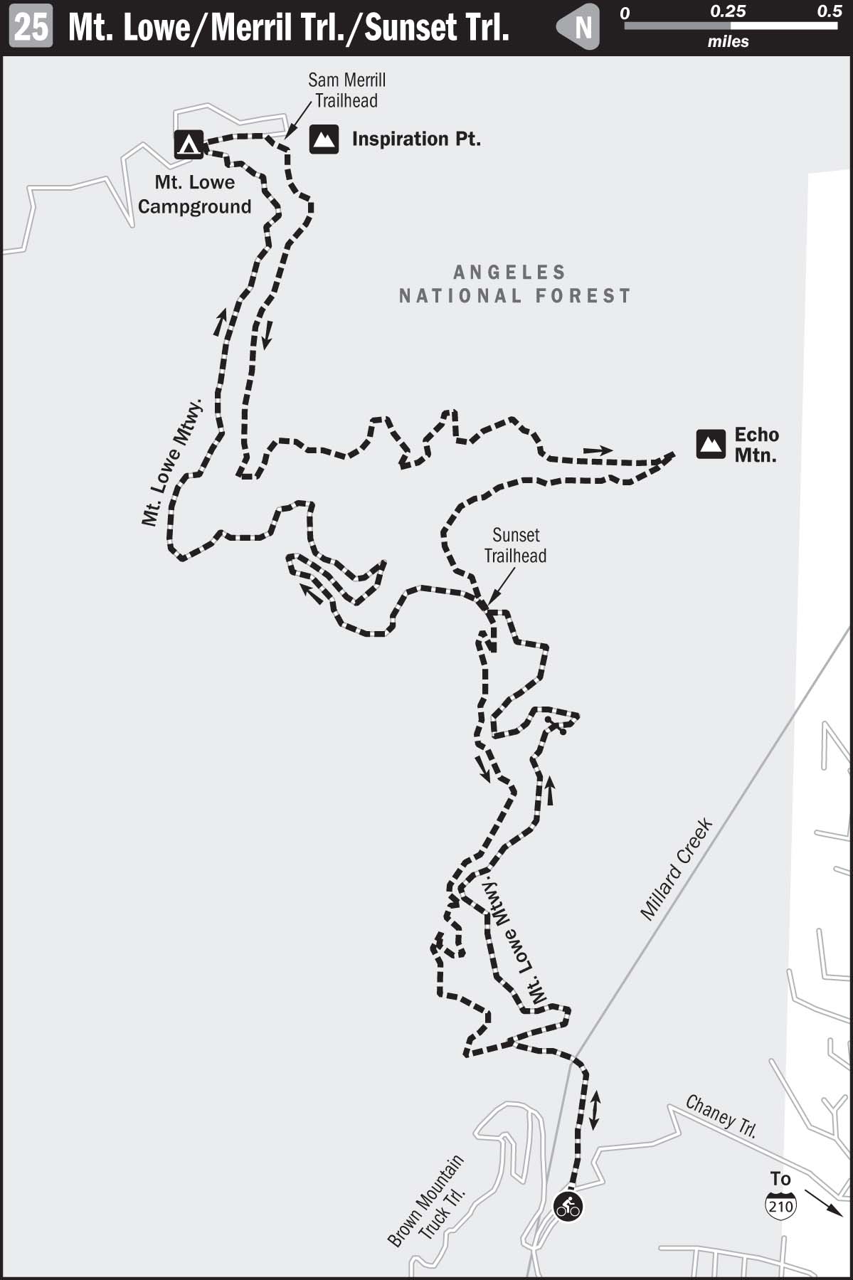
25 MOUNT LOWE RAILWAY/SAM MERRILL TRAIL/SUNSET TRAIL
KEY AT-A-GLANCE INFORMATION
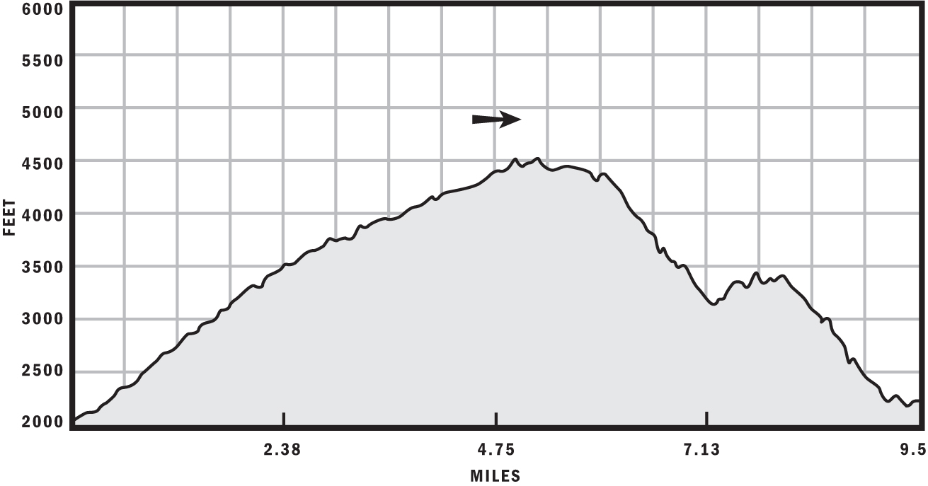
Length: 9.5 miles
Configuration: Figure-8
Technical difficulty: 4
Aerobic difficulty: 4
Scenery: Echo Mountain, Millard Canyon, Mount Lowe, Muir Peak
Exposure: 80% exposed to sunshine
Trail traffic: Moderate on weekdays, heavy on weekends
Trail surface: Dry, loose, and boulder-strewn on the descent, dry and hard-packed on the way up
Riding time: 2.5–3.5 hours
Access: Sunrise–sunset, 7 days a week
Maps: USGS 7.5-minute quads: Pasadena, Mount Wilson
Special comments: A Forest Adventure Pass is required for each parked vehicle. These can be purchased for $5 from various private vendors and ranger stations listed at www.fs.fed.us/r5/sanbernardino/ap/welcome.shtml.
GPS TRAILHEAD COORDINATES (WGS84)
UTM Zone 11S
Easting 395846
Northing 3786602
Latitude N 34.12′55″
Longitude W 118.07.50
DIRECTIONS
From I-210 in Altadena, take the Lake Avenue exit, and head north about 3.5 miles to the dead end and Loma Alta Drive. Turn left onto Loma Alta; continue 1 mile, and make a right onto Chaney Trail. Ascend Chaney Trail about 1 mile, watching for the gateway to Mount Lowe Railway on your right before making a hard downhill left turn. Park on the shoulder near the gate, and display your Forest Adventure Pass.
In Brief
This route has it all: a challenging, lung- and leg-burning ascent, great views, numerous plaques with historical factoids to read on the way up, and a heart-stopping descent with endless technical challenges and sheer cliffs nearby to test your intestinal fortitude. The Mount Lowe Railway, with the descents on Sam Merrill and Sunset trails, will challenge riders of all skill levels and must be experienced by everyone.
Safety Message
Novice riders be wary: the entire trail is exposed to many steep drop-offs and cliffs. It may be best to avoid this trail entirely if your technical skills aren’t up to par.
Description
The Mount Lowe Railway is what remains of an old railroad track that was built before the turn of the 20th century and that remained in operation until the mid-1930s. It transported travelers to various points of interest at the summit and to two fancy mountain chalets. Few remnants of the actual tracks remain, but the ruins of some of the facilities still stand at the summit. Don’t worry—the many plaques alongside the railway will answer any questions you have about the history of this site.

Jason Tuttle breaks in his new Heckler.
After you’ve geared up with 100 ounces of water and pocketed your cell phone (this is a dangerous ride, remember), start spinning up the railway. Numerous informative plaques will start to appear after the first mile, but don’t read all of them because you have to gain nearly 3,500 feet over the next 5 miles. Ouch! As long as it isn’t a hot, buggy day, it’s an easy ascent (if there is such a thing) because it’s mostly paved, albeit very steep in some sections.
Resist the temptation to stop when you get tired. Stopping only makes it more difficult because you lose the invaluable warmth that has built up in your legs. Even after a measly 5-minute rest, your legs will cool significantly and the pain will be much more severe when you start again. Just keep spinning and try to think about something other than your fatigue. Eventually, the pain will go away.
At the 5-mile mark, you’ve reached the Mount Lowe Campground, which sits atop the ruins of the Mount Lowe Tavern. This is a great place to refuel your body for the demanding descent that lies ahead. After you’ve hydrated yourself and munched on gimmicky exercise foods, pedal up the road a quarter mile farther to the entrance to Sam Merrill Trail, marked by a weathered sign on the right.
The beginning of the Sam Merrill Trail has too many impassable technical obstructions to allow you to build any kind of momentum, which gets kind of frustrating. You’ll soon find that Sam Merrill Trail isn’t an easy bomb—you’re always on the edge, constantly negotiating sharp turns, boulders, and ruts. It’s very demanding. In fact, a five-minute rest is recommended here more than on the way up Mount Lowe Railway. You are too far from help to risk an injury resulting from fatigue getting the best of you.
Take a hard right on Echo Mountain Trail at the 7.3-mile mark, which is the top of Echo Mountain, the site of the ruins of the old White City Resort. Echo Mountain Trail traverses Las Flores Canyon for 0.8 miles, with many steep cliffs on the left along the way. A word of advice: look where you want to go instead of where you don’t and you won’t have any problems.
At the 8-mile mark, go left on the Mount Lowe Railway for a few feet, and then turn right to descend Sunset Trail, which is slightly less hairy than Sam Merrill but very technical nonetheless. After oodles of grin-inspiring singletrack action, take a left roughly 9.6 miles from the start to go back to the Mount Lowe Railway and avoid descending all the way to the Millard Picnic Area.
Congratulations: you’ve just completed the toughest 10 miles of riding, bar none, in all of SoCal. You now have bragging rights, great stories to tell, and a higher IQ score—courtesy of all the informative plaques you read on the way up.
After the Ride
Since you just revisited history on the old Mount Lowe Railway, you might want to return to the days when soul food was considered healthy—stop at the award-winning Big Mamma’s Rib Shack at 1453 North Lake Avenue in Pasadena; (626) 797-1792. If that sort of free living alarms you, try Orean Health Express at 817 North Lake Avenue; (626) 794-0861.