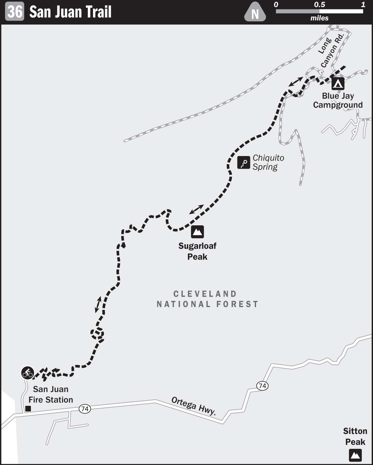
36 SAN JUAN TRAIL
KEY AT-A-GLANCE INFORMATION
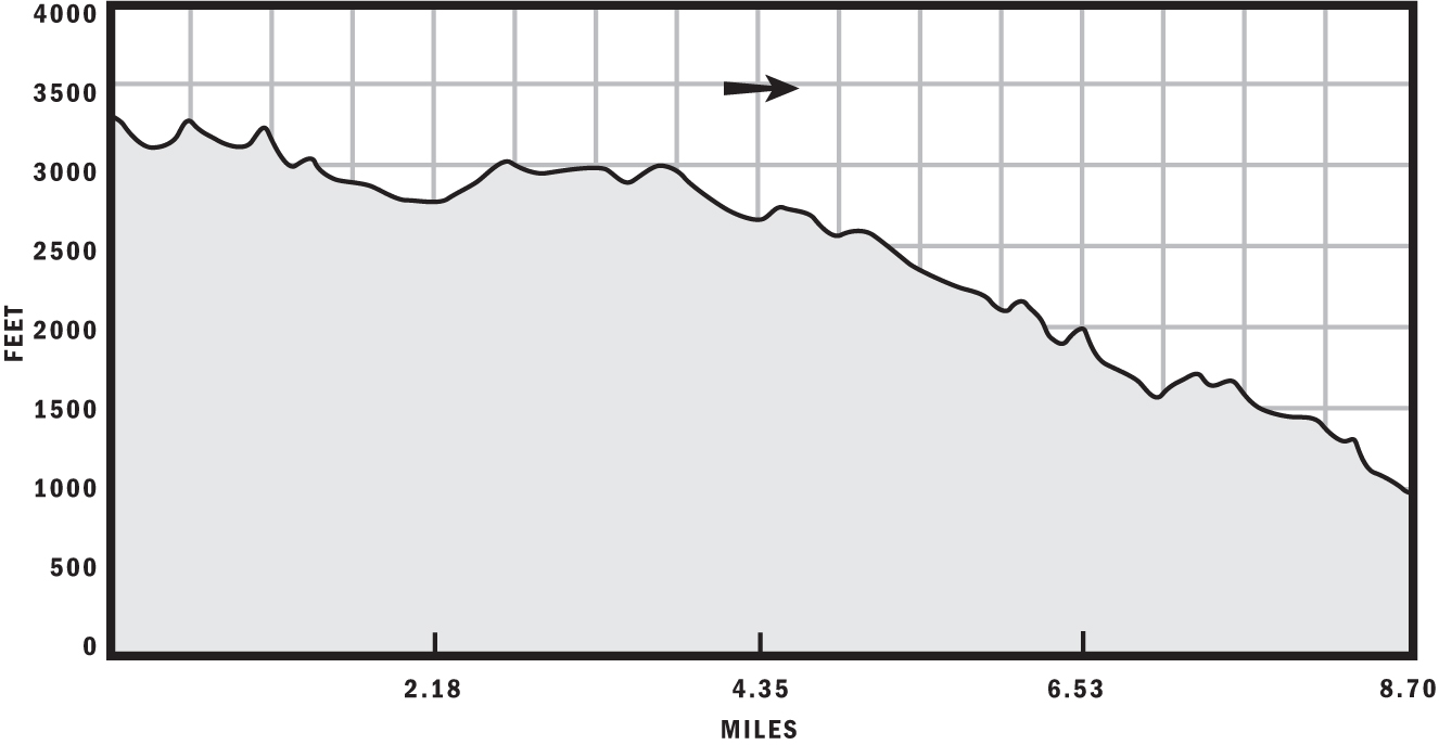
Length: 8.7 miles
Configuration: Point-to-point shuttle run or out-and-back
Technical difficulty: 4
Aerobic difficulty: 2 for shuttle run, 4 for out-and-back
Scenery: Sugarloaf Peak, Cold Spring Canyon, Hot Spring Canyon, Lion Canyon, San Juan Canyon, Santa Ana Mountains
Exposure: 75% exposed to sun
Trail traffic: Light on weekdays, moderate on weekends
Trail surface: Dry hardpack with embedded rocks and roots—100% singletrack
Riding time: 2–3 hours
Access: Sunrise–sunset, 7 days a week
Maps: USGS 7.5-minute quads: Alberhill, Canada Gobernadora
Special comments: All parked vehicles must display Forest Adventure Passes, which you can purchase for $5 from various private vendors and ranger stations listed at www.fs.fed.us/r5/sanbernardino/ap/welcome.shtml.
GPS TRAILHEAD COORDINATES (WGS84)
(start of shuttle run)
UTM Zone 11S
Easting 458459
Northing 3723685
Latitude N 33.39′08″
Longitude W 117.26′53″
DIRECTIONS
From Los Angeles, take I-405 south to San Juan Capistrano, and exit at CA 74 (Ortega Highway). Head north on CA 74 about 12.5 miles, and turn left at the San Juan Fire Station. Drive past the fire station, and continue about 0.75 miles until you reach the dirt lot, bathroom, and signs for San Juan Trail. Stage one of your vehicles here if you’re shuttling; load bikes, gear, and people into a second vehicle, and return to CA 74; head north about 9.2 miles, turn left onto Long Canyon Road, and, after about 2.5 miles, park on the left in front of the upper entrance to San Juan Trail. Blue Jay Campground sits just beyond the entrance.
In Brief
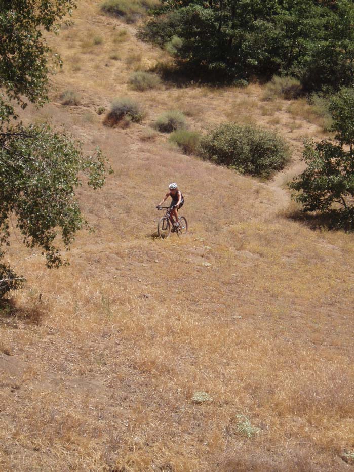
The San Juan Trail truly is one of the finest stretches of singletrack in SoCal. The trail boasts every feature of an ideal two-wheeled romp, including technical rock gardens, steep bomb runs, kickers, and fast-banked turns, with the picturesque panorama of the Santa Ana Mountains in the Cleveland National Forest as an exquisite backdrop. Switchbacks form the defining characteristic of this playground: more are found on this 8.7-mile stretch than in any other locale—I lost count after ten in the first mile of ascent. Although this ride is recommended as a shuttle run, it is probably best enjoyed ridden up and then down. The throbbing pain in your legs and lungs is hard to notice when there is so much to see and so many obstacles to negotiate. If your bike was built for anything other than downhill duty and you’ve got the time, please abort the shuttling mission. Better yet, ride the whole thing and then shuttle it, because afterward you’ll surely want another slice of downhill indulgence.
Description
Since you’re entering remote territory, prepare for this ride as you would for any cross-country epic, with air, tubes, jacket, snacks, tools, maximum water, and a cell phone, if possible. You may be wondering why a shuttle run requires all the gear. You need all that stuff because you simply never know what is going to happen. My riding buddy had a frame failure smack-dab in the middle of the route. An incident like that usually results in a lot of hiking (that’s where the water and snacks come in handy) if the frame cannot be fixed (tools) and the rider wasn’t injured (cell phone).

Patrick Rose having fun before his frame broke
The route starts with an oak-shaded descent that is particularly steep and technical because of large embedded rocks and deep rain ruts. At about 1.5 miles, continue straight at the intersection, following the path most traveled. After the intersection, the trail flattens out as you pass under tall oaks. At about 2 miles, dismount for a creek crossing atop a sketchy natural bridge made of oak tree roots. After the crossing, ascend a short but steep and technical climb, which presents a challenge rarely encountered anywhere in SoCal—tree roots, lots of them.
After the root-addled ascent, you’ll see no major elevation gains or losses, but the terrain will morph from shaded oak forest floor to a manzanita grove with orange-hued soil fully exposed to sunshine. At the 3.5-mile mark, after you pass the rocky Sugarloaf Peak on your right, the trail turns sharply to the right (ignore the narrow trail going left) and becomes rocky and technical for the next half mile. After the rocky sections, the trail levels out and becomes the archetypal singletrack for which it is famous—narrow, fast, unimpeded by foliage, with sweeping, bermed corners, and composed of a grippy, dry, compact, orange crust. The waist-level manzanita plants that dominate the area aren’t tall enough to block your view of approaching corners, but don’t lean into them—the stems are less forgiving than steel wire and will rip you off your bike. You’ll have several opportunities to lose contact with the ground in this section for some hang time, but it’s up to you to find the right line that leads to the kicker.
After the 6-mile mark, the trail gets looser and steeper, with a series of somewhat challenging turns and switchbacks. Get used to turning because at about the 8.4-mile mark, you’ll have to negotiate ten-plus very tight switchbacks before you get dumped out into the lower parking lot at roughly 8.7 miles, marking the end of your ride.
GPS Trailhead Coordinates (WGS84)
(End of shuttle run)
UTM Zone 11S
Easting 452589
Northing 3718052
Latitude N 33.36′04″
Longitude W 117.30′40″
After the Ride
The immediate vicinity of San Juan Trail offers zero food-serving venues, so your best bet for immediate nourishment after the ride is to bring your own. If you left your cooler at home and are sick of energy goo, try dining at former president Richard Nixon’s favorite Mexican restaurant, El Adobe de Capistrano, at 31891 Camino Capistrano in San Juan Capistrano; (949) 493-1163. For cheaper but by no means less presidential Mexican cuisine, stop by Las Golondrinas, at 27124 Paseo Espada, Suite 803; (949) 240-3440.