37 LOWER ROCK CREEK TRAIL
KEY AT-A-GLANCE INFORMATION
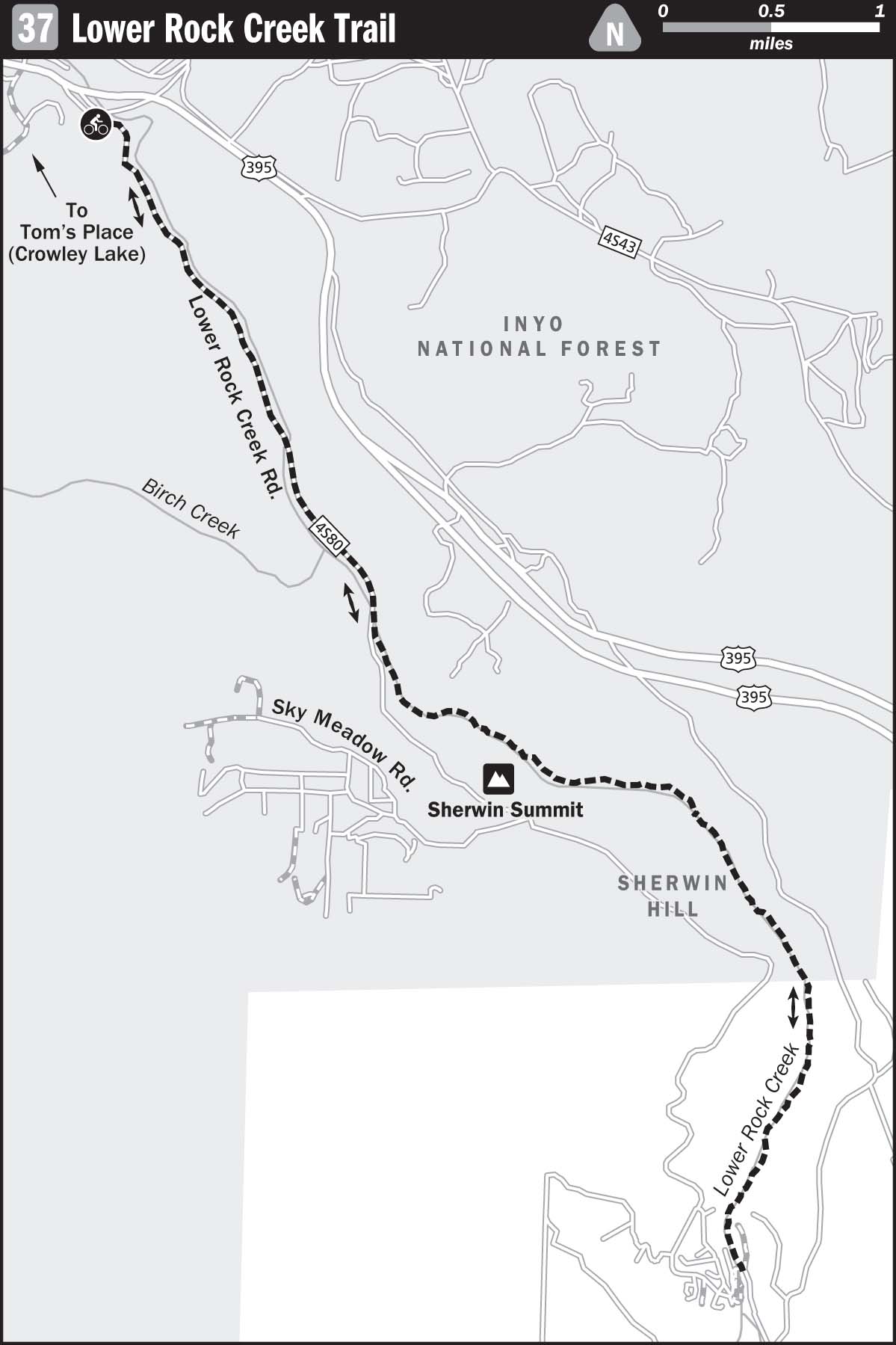
Length: 7.8 miles
Configuration: Point-to-point shuttle ride
Technical difficulty: 5
Aerobic difficulty: 1
Scenery: Lower Rock Creek Canyon
Exposure: 30% exposed to sunshine
Trail traffic: Light–moderate on weekdays, moderate–heavy on weekends
Trail surface: Varies from loose and rocky to sandy and loamy—95% singletrack
Riding time: 0.5–1.5 hours
Access: Sunrise–sunset, 7 days a week
Maps: USGS 7.5-minute quad: Casa Diablo Mountain, Tom’s Place, Rovana
Special comments: Sharp-edged rocks are common on this route, so be prepared with a spare tube, tire levers, a patch kit, and a source of air.
GPS TRAILHEAD COORDINATES (WGS84)
UTM Zone 11S
Easting 353400
Northing 4157965
Latitude N 37.33′25″
Longitude W 118.39′35″
DIRECTIONS
From Los Angeles, take Interstate 405 north to I-5 north; go 3.1 miles, and join CA 14, driving 118.3 miles until it becomes US 395. Continue 122 miles on US 395 to the town of Bishop. Drive 12 miles beyond the US 395–US 6 junction, on US 395, until you reach an exit for Gorge Road. Turn left onto Gorge Road, and then right onto Lower Rock Creek Road after about 0.2 miles. Continue up Lower Rock Creek Road about 3 miles until it crosses Lower Rock Creek and makes a 180-degree turn. Here, you’ll see the site of a former campground and restaurant. Leave one vehicle here, load the bikes and riders in a second vehicle, and continue up Lower Rock Creek Road about 7.9 miles (it actually becomes Old Sherwin Grade Road along the way) until it rejoins US 395. The upper entrance to Lower Rock Creek Trail is just before the intersection with US 395 and is clearly marked by a sign. Park opposite the trail entrance, along Old Sherwin Grade Road.
In Brief
Any complaints about the 286-mile drive to get here will be quashed by one shuttle run down Lower Rock Creek Trail. This route involves a beautifully crafted singletrack that parallels Rock Creek as it cascades through a massive gorge of its own making, dropping nearly 2,000 feet from Tom’s Place to the Owens Valley floor. The lower half of the trail is very technical and can be ridden completely dab-free by only the best riders on the planet. You’ll find lots of great places to picnic and swim on the way down. With no admission fee, Lower Rock Creek Trail is definitely a great alternative to bombing the downhill runs at Mammoth Mountain.
Description
Once you’ve gotten all your cars and riders properly situated, start your bomb down the trail, but don’t forget one very important item—the keys to the vehicle at the bottom. Without these, you’ll have to lug your heavy downhill rigs up Lower Rock Creek Road, which is an excruciating grinder.
Keep it rubber-side down, folks.
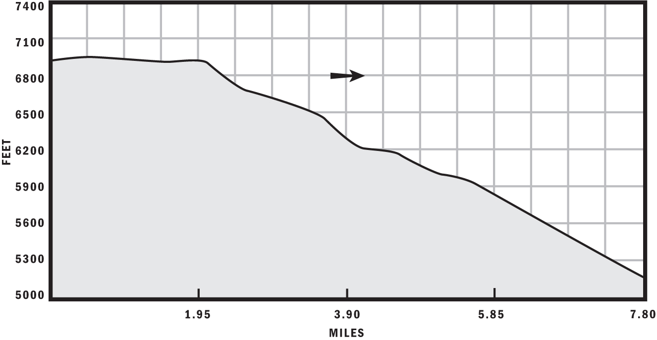
For the first 2 miles of the ride, you’ll need to pedal hard to get any speed because you’ll lose relatively little elevation over that stretch. Nevertheless, a few fast sections will give you an idea of what this trail is about—a pristine foot-wide path of varying soil compositions that often snakes among trees, giving the rider three dimensions of technical riddles to solve. The soil on the first section is the driest on the route, with far fewer rocks than down below. Things don’t get really interesting until after the first road crossing.
The trail dumps you out onto Sherwin Grade Road roughly 2.1 miles from the start. After looking for fast-moving traffic, ride up the road a few feet (north), and look for the reentry to the trail on the other side. The trail immediately gets exciting. Watch out for a nice little kicker on the right side about a quarter of a mile in. Much of this section is composed of both wet and dry loam, but it still doesn’t deliver any hurdles of great technical difficulty. After roughly 1 mile, you’ll cross the road one last time.
The entrance is easily visible directly across the road. At this entry, the trail becomes a steep chute, diverging from the road completely. At about 3.8 miles from the start, a wood bridge takes you to the north side of the creek, and the trail morphs into a rocky mess. The remaining 4 miles are action-packed—very rocky and technical—difficult to clean on even a 10-inch travel-downhill rig. About halfway through this section, the trail flattens out a bit, and you’ll see several snack and rest areas among the tall pines. Take a break, and take in your surroundings—you’re inside the trough of a deep gorge carved through dense granite over thousands of years. The trail is the only way out, which is fine, provided your body or bike didn’t sustain any damage on the way down.

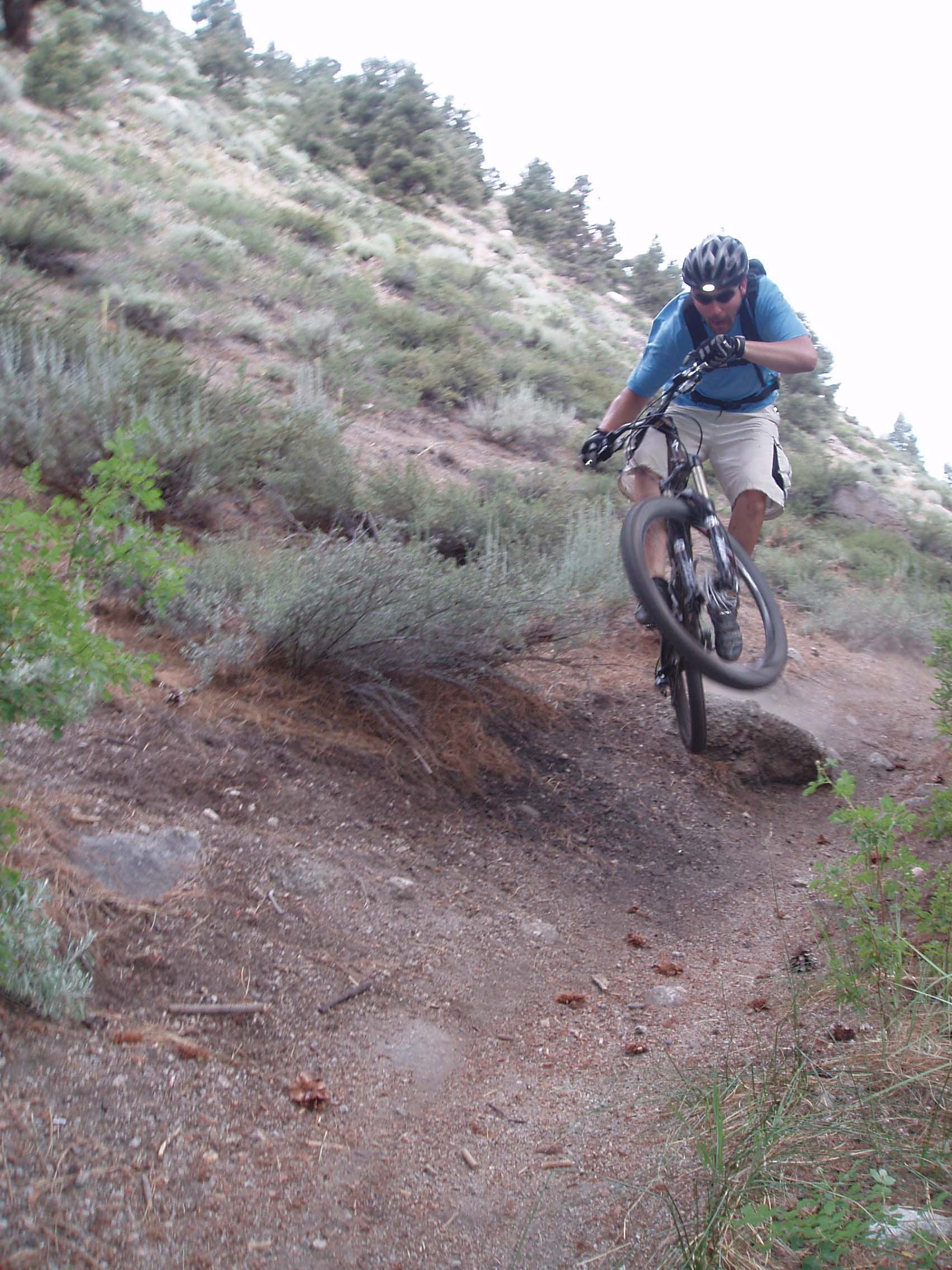
On her next run, Gabriela rode over this obstacle dab-free.
To cool off, take a dip in the snowmelt runoff that is Lower Rock Creek—after all, you’ve been cooking in 90-plus-degree heat—then hop back on your rig and finish the descent. You will most certainly need to do another run. A mere 7.8 miles of singletrack of this caliber isn’t enough to justify the long drive out here. No matter how many runs you take, you can laugh at the masses that flocked to Mammoth Ski Resort and forked over large dough to ride the dusty, pumice-covered turf there. For merely the cost of gas, you probably had more fun than they did.
After the Ride
For tasty burgers and suds, visit Tom’s Place Café, at 8189 Crowley Lake Drive in the town of Crowley Lake; (760) 935-4239. For bonehead mistakes like leaving your helmet or cycle shoes at home—300 miles from the trail—Aerohead Cycles in Bishop can get you outfitted. They are at 312 North Warren Street; (760) 873-4151.