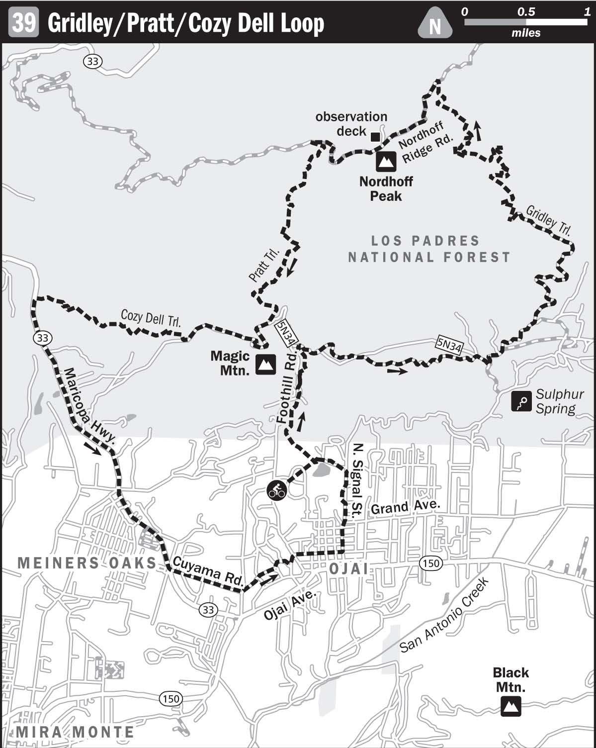
39 GRIDLEY/PRATT/COZY DELL LOOP
KEY AT-A-GLANCE INFORMATION
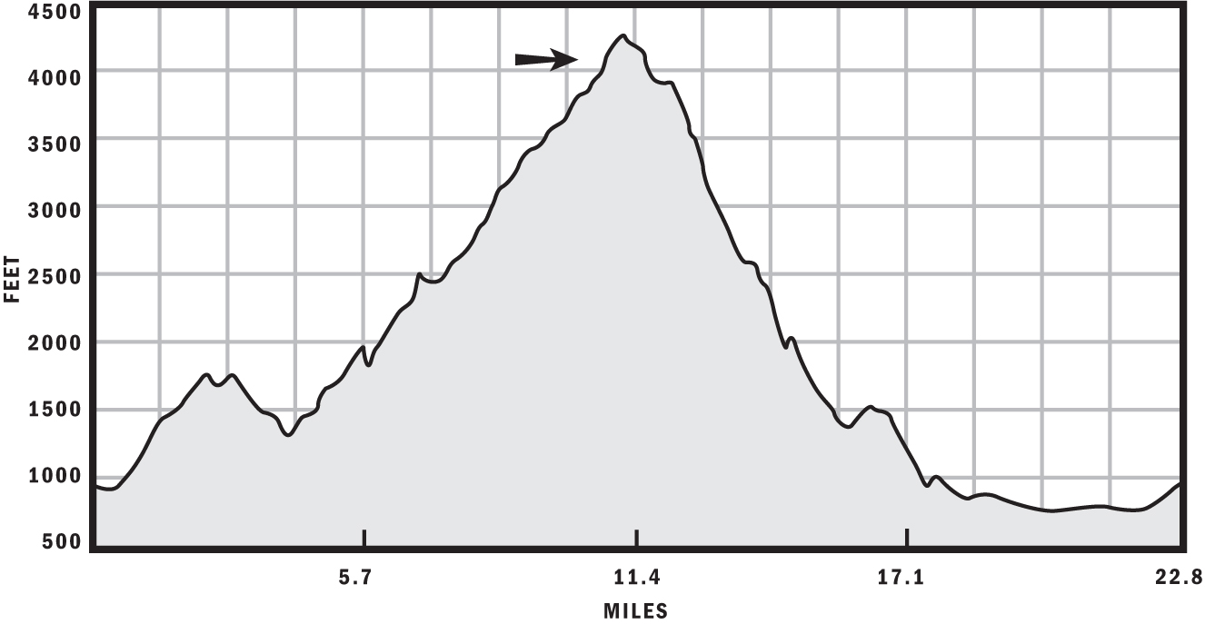
Length: 22.8 miles
Configuration: Loop
Technical difficulty: 4
Aerobic difficulty: 5
Scenery: Ojai Valley, Gridley Canyon, Nordhoff Peak, Nordhoff Ridge, Stewart Canyon, Pacific Ocean, Lake Casitas, Ventura County, Channel Islands
Exposure: 70% exposed to sunshine
Trail traffic: Light on weekdays, moderate on weekends
Trail surface: Mostly hardpack, with embedded rocks and some loose, shaley sections—55% singletrack
Riding time: 4–6 hours
Access: Sunrise–sunset, 7 days a week
Maps: USGS 7.5-minute quads: Matilija, Ojai, Lion Canyon
Special comments: Because of the huge amount of climbing involved, bring at least 70 ounces of water and some snacks.
GPS TRAILHEAD COORDINATES (WGS84)
UTM Zone 11S
Easting 293314
Northing 3815515
Latitude N 34.27′38″
Longitude W 119.15′00″
DIRECTIONS
From Los Angeles, take US 101 north about 50 miles; then take the CA 33 exit north toward Ojai. After about 13.2 miles, merge with CA 150 east; turn left onto Signal Street after 1 mile. Continue on Signal about 1 mile until it terminates in a dirt lot. Park here and find the trailhead at the southwest end of the lot.
In Brief
With more than 5,000 feet of total elevation gain, the Gridley/Pratt/Cozy Dell Loop is a true ass-kicker. Don’t let its measly 22-plus miles fool you—the first 11 miles are mostly uphill, and the climbing just increases in severity the farther you go. The last 0.75 miles are devastatingly steep, but your effort will be rewarded with one of the best panoramic views anywhere. The downhill is just as intense, with plenty of off-camber turns and embedded rocks to enrich your endorphins. This route is perhaps the most challenging single loop in SoCal. Prepare to be humbled, no matter how in shape you think you are.
Description
Because you’re about to embark on one of the most physically demanding rides of your life, you may want to extend your normal pre-ride prep to include rituals like contacting dead relatives, transcendental meditation, yoga, and possibly Pilates. At the very least, stretch a little, fill your H2O receptacles to the brim, and pack two tubes, a patch kit, a multitool, a cell phone, and snacks. This ride is so demanding that you’ll definitely need calorie replenishment at some point during the climb. Something that’s easy on your stomach will work best: an energy drink, carbohydrate goo, or some other liquid supplement.
After you’ve made peace with your deity of choice, hop on your steed and start climbing Pratt Trail. The first 1.5 miles of Pratt are a rock garden, so unless you have uncanny trail bike skills, you’ll be carrying your ride over much of it. This section of trail is unique because it skirts the boundaries of several parcels of private land, and at one point you’re literally in someone’s backyard.

Mike Stanosek’s bike at the top of Gridley
Leave Pratt Trail for later by turning right onto the fire road at roughly 1.8 miles from the start. This road begins as a wide, groomed fire road but becomes singletrack about halfway along as it traverses over to Gridley Trail for just over 2 miles. Although this is a traverse, it still involves a healthy dose of climbing. You’ll know you’re at Gridley when you see an avocado grove—at this point, roughly 4 miles from the start, turn left and start ascending the fire road that rises through the avocado-covered hillside.
Provided you haven’t stopped to make guacamole, continue beyond the grove and start Gridley Trail proper, which is the prototypical SoCal singletrack—narrow, dry hardpack with embedded sandstone rocks scented by the fragrant flora of the chaparral environment. The route doesn’t get really steep and hairy until just beyond the 7-mile mark, when a mellow trail of mild grade becomes a steep, seemingly never-ending series of switchbacks and false summits that will have you begging for mercy. The Gridley singletrack comes to an end at Nordhoff Fire Road, roughly 9.7 miles from the start. Most bikers get to relax here because attempting the remaining grind to Nordhoff Peak would be insanity.
Since you’re living on the edge on this particular day, put away your camera and snacks and hang a left onto Nordhoff Road to crest the summit. Even if you hadn’t just completed one of the hardest singletrack ascents in SoCal, this last climb would be brutal because, although it’s groomed and flat, Nordhoff Road is very steep. Huff and puff your way to the top. At roughly the 11-mile mark, a short spur of road climbs the hill to the right to a large steel observatory. Please check it out! It’s definitely worth the extra pain. On a clear day, you can see the Channel Islands from there.
After enjoying the panorama, head back to Nordhoff Road, continue westbound about 0.8 miles, and turn left onto Pratt Trail, which is marked by a sign that has an arrow and the words signal road: 5 miles. Signal Road is where you parked your car, remember? Turn left here and begin the descent of nasty, narrow Pratt Trail. The main hazard on this trail is not an overwhelming number of rocks but many off-camber turns and areas where it’s very easy to slide off the trail. Provided your tires aren’t overinflated and your knobbies are fresh, this section should not be a problem if you’re wary and skilled.
At about 14.6 miles from the start, Pratt Trail will reach a junction with Cozy Dell Fire Road. Turn right here, and continue about 1.1 miles until you reach a singletrack that branches off to the right—this is Cozy Dell Trail—for the last chapter in this saga. If you’re not so thoroughly thrashed that you can ride this 2-mile stretch of rock gardens and switchbacks without collapsing in the bushes or crashing, you’re definitely in good shape. At 17.7 miles, turn left onto CA 33 to conclude your route on pavement. Just beyond the 20.2-mile mark, turn left onto Cuyama Road, and stay on Cuyama until it becomes East Aliso Street. Turn left onto Signal Street to return to your car.
Congratulations: you’ve just completed one of the nastiest rides in SoCal! The only route that rivals this one in terms of elevation gain is the Mount Wilson Toll Road, but this route is arguably much tougher because much of the climbing takes place on technical singletrack that keeps you out of the saddle most of the time. Consider the Gridley/Pratt/Cozy Dell Loop a right of passage, making you a fat-tire crusader of the highest order.
After the Ride
After so many hours in the bush, it totally makes sense to dine on wild game and wash it down with Guinness on tap at The Deer Lodge in Ojai, at 2261 Maricopa Highway; (805) 646-4256. For more-immediate gratification, try Oh Hi Frostie for burgers and milkshakes, at 214 West Ojai Avenue; (805) 646-1923.