
Ah, the wonders of nature. So peaceful. So majestic. So … weird? Just take a look around, and you’ll see that we are surrounded by bizarre natural phenomena: giant mucuslike sea blobs in the Mediterranean Sea, enormous sinkholes that swallow three-story buildings in Guatemala, a supervolcano lurking beneath Yellowstone National Park, and a Mexican cave filled with giant crystals measuring 36 feet (11 meters) long. It looks like nature might be trying to freak us out.
The world’s oldest known living tree, a conifer that first took root at the end of the last Ice Age, has been discovered in Sweden, researchers say.
Discovered in 2004, a lone Norway spruce—of the species traditionally used to decorate European homes during Christmas—growing at an altitude of 2,985 feet (910 meters) in Dalarna Province was deemed to be the world’s oldest living plant.
The visible portion of the 13-foot-tall (4-meter-tall) “Christmas tree” isn’t ancient, but its root system has been growing for 9,550 years, according to a team led by Leif Kullman, professor at Umeå University’s Department of Ecology and Environmental Science in Sweden.
The tree’s incredible longevity is largely due to its ability to clone itself Kullman said. The spruce’s stems or trunks have a lifespan of around 600 years, “but as soon as a stem dies, a new one emerges from the same root stock,” Kullman explained. “So the tree has a very long life expectancy.”

The roots of this tree date back 9,550 years. (Photo Credit 9.2)
Bristlecone pines in the western United States are generally recognized as the world’s oldest continuously standing trees. The most ancient recorded, from California’s White Mountains, is dated to around 5,000 years ago. Bristlecone pines are aged by counting tree rings, which form annually within their trunks.
But in the case of the Norway spruce, ancient remnants of its roots were radiocarbon dated. The study team also identified other ancient spruces in Sweden that were between 5,000 and 6,000 years old.
Trees much older than 9,550 years would be impossible in Sweden, because ice sheets covered the country until the end of the last Ice Age around 11,000 years ago, Kullman noted.
Ten of the Oldest Trees in the World
1. Methuselah, Inyo National Forest, California—4,765 years old
2. Zoroastrian Sarv, Abarkooh, Iran—between 4,000 and 4,500 years old
3. Llangernyw Yew, Llangernyw, Wales—between 3,000 and 4,000 years old
4. Alerce Tree, Andes Mountains, Chile—3,620 years old
5. The Senator, Big Tree Park, Florida—3,500 years old
6. General Sherman, Sequoia National Park, California—2,300 years old
7. Jömon Sugi, Yakushima Island, Japan—2,000 years old
8. Te Matua Ngahere, Waipoua Forest, New Zealand—2,000 years old
9. Kongeegen, Jægerspris North Forest, Denmark—between 1,500 and 2,000 years old
10. Jardine Juniper, Cache National Forest, Utah—1,500 years old
The research forms part of an ongoing study into how and when trees colonized Scandinavia after it had thawed. “Prior to our studies the general conception was that spruce migrated to this area about 2,000 years ago, so now you will have to rewrite the textbooks,” Kullman said.
“Deglaciation seems to have occurred much earlier than generally thought,” he added. “Perhaps the ice sheet during the Ice Age was much thinner than previously believed.” The tree study may also help shed light on how plants will respond to current climate change, Kullman said. “We can see trees have an ability to migrate much faster than people had believed,” he said.
In fact, global warming made the ancient mountain conifers easier for the study team to find. “For many millennia they survived in the mountain tundra as low-growing shrubs perhaps less than a meter high,” Kullman said. “Now they are growing up like mushrooms—you can see them quite readily.”
But climate change could also swamp these living Ice Age relics, he warned. The tree line has climbed up to 655 feet (200 meters) in altitude during the past century in the central Sweden study area, the team found.
“A great change in the landscape is going on,” Kullman said. “Some lower mountains, which were bare tundra less than a hundred years ago, are totally covered by forest today.”
Mountains tend to provide a refuge for the planet’s most venerable trees because of reduced competition from neighbors and other plants and because the sparser vegetation around the timberline is less vulnerable to forest fires, Kullman said.
Another factor is reduced human impacts such as logging, said Tom Harlan of the Laboratory of Tree-Ring Research at the University of Arizona. “Human activity lower down has demolished all sorts of things that could have been extremely old,” he said.
Harlan says the newly dated Swedish spruce trees have “quite an extraordinary age.” “I have no great problems with them having a tree which has been growing there for more than 8,000 years,” he said. “The date seems a little early but not out of line with other things we have seen.”
For instance, Harlan noted, dead remains of Californian bristlecone pines dating to about 7,500 years ago have been found up to 500 feet (150 meters) higher in altitude than any living bristlecones. “So there was a time period then when trees were pushing aggressively into areas they had not been in before,” he said.

Other tree clones may have an even more ancient lineage than the Swedish spruces, he added. Research suggests that stands of Huon pines on the Australian island of Tasmania possibly date back more than 10,000 years. 
TRUTH:
THE WORLD’S TALLEST TREE IS 379.1 FEET TALL, ABOUT AS HIGH AS 188 SCHOOL DESKS STACKED UP.
Every spring and fall, clock confusion reigns supreme: When exactly does daylight saving time end, and why do we do it?
For most Americans, daylight saving time ends in early November, when most states fall back an hour. Time springs forward to daylight saving time in March, when daylight saving time begins again.
Where it is observed, daylight saving time has been known to cause some problems. National surveys by Rasmussen Reports, for example, show that 83 percent of respondents knew when to move their clocks ahead in spring 2010. Twenty-seven percent, though, admitted they’d been an hour early or late at least once in their lives because they hadn’t changed their clocks correctly.
It’s enough to make you wonder—why do we use daylight saving time in the first place?
No Thanks
The federal government doesn’t require U.S. states or territories to observe daylight saving time, which is why residents of Arizona, Hawaii, Puerto Rico, the Virgin Islands, American Samoa, Guam, and the Northern Marianas Islands don’t need to change their clocks.
Ben Franklin—of “early to bed and early to rise” fame—was apparently the first person to suggest the concept of daylight savings, according to computer scientist David Prerau, author of the book Seize the Daylight: The Curious and Contentious Story of Daylight Saving Time.
GEORGE VERNON HUDSON, A NEW ZEALAND ENTOMOLOGIST, FIRST SUGGESTED MODERN DAYLIGHT SAVING TIME IN 1895.
While serving as U.S. ambassador to France in Paris, Franklin wrote of being awakened at 6 a.m. and realizing, to his surprise, that the sun would rise far earlier than he usually did. Imagine the resources that might be saved if he and others rose before noon and burned less midnight oil, Franklin, tongue half in cheek, wrote to a newspaper. “Franklin seriously realized it would be beneficial to make better use of daylight but he didn’t really know how to implement it,” Prerau said.
It wasn’t until World War I that daylight savings were realized on a grand scale. Germany was the first state to adopt the time changes, to reduce artificial lighting and thereby save coal for the war effort. Friends and foes soon followed suit. In the United States, a federal law standardized the yearly start and end of daylight saving time in 1918—for the states that chose to observe it.
During World War II, the United States made daylight saving time mandatory for the whole country, as a way to save wartime resources. Between February 9, 1942, and September 30, 1945, the government took it a step further. During this period daylight saving time was observed year-round, essentially making it the new standard time, if only for a few years.

It’s hard to remember if it’s “fall back” or “spring ahead.” (Photo Credit 9.4)
Since the end of World War II, though, daylight saving time has always been optional for U.S. states. But its beginning and end have shifted—and occasionally disappeared. During the 1973 to 1974 Arab oil embargo, the United States once again extended daylight saving time through the winter, resulting in a 1 percent decrease in the country’s electrical load, according to federal studies cited by Prerau. Thirty years later the Energy Policy Act of 2005 was enacted, mandating a controversial month-long extension of daylight saving time, starting in 2007.
But does daylight saving time really save any energy?
“Light doesn’t do the same things to the body in the morning and the evening. More light in the morning would advance the body clock, and that would be good. But more light in the evening would even further delay the body clock.”
Till Roenneberg
chronobiologist, Ludwig-Maximillians University, Munich, Germany
In recent years several studies have suggested that daylight saving time doesn’t actually save energy—and might even result in a net loss. Environmental economist Hendrik Wolff, of the University of Washington, co-authored a paper that studied Australian power-use data when parts of the country extended daylight saving time for the 2000 Sydney Olympics and others did not. The researchers found that the practice reduced lighting and electricity consumption in the evening but increased energy use in the now dark mornings—wiping out the evening gains.
Likewise, Matthew Kotchen, an economist at the University of California, saw in Indiana a situation ripe for study. Prior to 2006, only 15 of the state’s 92 counties observed daylight saving time. So when the whole state adopted daylight saving time, it became possible to compare before-and-after energy use. While use of artificial lights dropped, increased air-conditioning use more than offset any energy gains, according to the daylight saving time research Kotchen led for the National Bureau of Economic Research in 2008.
That’s because the extra hour that daylight saving time adds in the evening is a hotter hour. “So if people get home an hour earlier in a warmer house, they turn on their air conditioning,” the University of Washington’s Wolff said. In fact, Hoosier consumers paid more on their electric bills than before they made the annual switch to daylight saving time, the study found.
But other studies do show energy gains. In an October 2008 daylight saving time report to Congress, mandated by the same 2005 energy act that extended daylight saving time, the U.S. Department of Energy asserted that springing forward does save energy. Extended daylight saving time saved 1.3 terawatt hours of electricity. That figure suggests that daylight saving time reduces annual U.S. electricity consumption by 0.03 percent and overall energy consumption by 0.02 percent. While those percentages seem small, they could represent significant savings because of the nation’s enormous total energy use.
What’s more, savings in some regions are apparently greater than in others. California, for instance, appears to benefit most from daylight saving time—perhaps because its relatively mild weather encourages people to stay outdoors later. The Energy Department report found that daylight saving time resulted in an energy savings of 1 percent daily in the state.
But Wolff, one of many scholars who contributed to the federal report, suggested that the numbers were subject to statistical variability and shouldn’t be taken as hard facts.
And daylight savings’ energy gains in the United States largely depend on your location in relation to the Mason-Dixon Line, Wolff said. “The North might be a slight winner, because the North doesn’t have as much air conditioning,” he said. “But the South is a definite loser in terms of energy consumption. The South has more energy consumption under daylight saving.”
For decades, advocates of daylight savings have argued that, energy savings or no, daylight saving time boosts health by encouraging active lifestyles—a claim Wolff and colleagues are currently putting to the test.
“In a nationwide American time-use study, we’re clearly seeing that, at the time of daylight saving time extension in the spring, television watching is substantially reduced and outdoor behaviors like jogging, walking, or going to the park are substantially increased,” Wolff said.
But others warn of ill effects. Till Roenneberg, a chronobiologist at Ludwig-Maximilians University in Munich, Germany, said his studies show that our bodies never adjust to gaining an “extra” hour of sunlight.
“The consequence of that is that the majority of the population has drastically decreased productivity, decreased quality of life, increasing susceptibility to illness, and is just plain tired,” Roenneberg said. One reason so many people in the developed world are chronically overtired, he said, is that their optimal circadian sleep periods are out of whack with their actual sleep schedules.
Shifting daylight from morning to evening only increases this lag, he said. “Light doesn’t do the same things to the body in the morning and the evening. More light in the morning would advance the body clock, and that would be good. But more light in the evening would even further delay the body clock.”
TRUTH:
EVERY DAY IS ABOUT 55 BILLIONTHS OF A SECOND LONGER THAN THE DAY BEFORE IT.
With verdicts on the benefits, or costs, of daylight savings so split, it may be no surprise that the yearly time changes inspire polarized reactions. In the United Kingdom, for instance, the Lighter Later movement—part of 10:10, a group advocating cutting carbon emissions—argues for a sort of extreme daylight savings. First, they say, move standard time forward an hour, then keep observing daylight saving time as usual—adding two hours of evening daylight to what we currently consider standard time.
The folks behind standardtime.com, on the other hand, want to abolish daylight saving time altogether. Calling energy-efficiency claims “unproven,” they write: “If we are saving energy let’s go year round with Daylight Saving Time. If we are not saving energy let’s drop Daylight Saving Time!”
But don’t most people enjoy that extra evening sun every summer? Even that remains in doubt. National telephone surveys by Rasmussen Reports from fall 2009 and spring 2010 deliver the same answer: Most people just “don’t think the time change is worth the hassle.” Forty-seven percent agreed with that statement, while only 40 percent disagreed.
But Seize the Daylight author David Prerau said his research on daylight saving time suggests most people are fond of it. “I think the first day of daylight saving time is really like the first day of spring for a lot of people,” Prerau said. “It’s the first time that they have some time after work to make use of the springtime weather. I think if you ask most people if they enjoy having an extra hour of daylight in the evening eight months a year, the response would be pretty positive.”
Three weird clouds appeared in the sky over South Carolina in January 2011, and a local photographer snapped a picture. After he posted it on the Internet, it seems everyone had a theory about them. But what’s the real story?
Three nearly identical, UFO-like cloud formations appeared over Myrtle Beach, South Carolina, in January 2011, sparking online discussions linking the features to everything from the Second Coming to recent mass bird deaths to secret military experiments. At least one scientist believes the so-called hole-punch clouds have a military explanation, though it may not be quite what conspiracy theorists expect.
What Are Little Clouds Made Of?
Earth isn’t the only planet covered with clouds. Earth’s sister planet Venus has them, too. Instead of being composed of water droplets and ice crystals, though, Venus’s clouds are made of sulfuric acid, and would be deadly to humans.
On January 7, 2011, IT technician Wesley Tyler was running out to his car for a computer part when he noticed the saucerlike formations. “At first we thought they were tornado clouds, but the air was so still—like mausoleum still,” Tyler said. “You just knew it was unusual. I’ve lived on the beach for years and never seen anything like that.”
Back home, he uploaded pictures of the clouds to Facebook, tagging a meteorologist friend, who later identified the phenomena as hole-punch clouds, or punch-hole clouds.
Hole-punch clouds are miniature snowstorms that can occur in thin, sub-freezing cloud layers. The lack of fine particles, such as dust, in the clouds means water droplets have little to condense around, so they don’t turn to ice until the cloud hits about minus 38 degrees Fahrenheit (minus 36 degrees Celsius).
“Basically, the water molecules become sluggish enough at this temperature to form their own cluster of ice that produces an ice crystal spontaneously,” according to ice microphysicist Andrew Heymsfield.
When airplanes ascend into this type of cloud, the rearward force created by propellers or by air forced over wings causes air to expand. This expansion can cool a vaguely circular section of the cloud to the point where many of the water droplets freeze and ice crystals form, according to a June hole-punch cloud study co-authored by Heymsfield in the Bulletin of the American Meteorological Society.
Over the next 45 minutes or so, ice crystals grow and spread outward, often resulting in a tightly contained, roughly half-hour snowstorm—leaving behind a hole “punched” in the cloud.

A hole-punch cloud over Mobile, Alabama (Photo Credit 9.5)
Tyler, the photographer, was skeptical of the airplane explanation, due to the sheer number and close proximity of the cloud formations. “I’ve scoured the Internet and have yet to find more than one hole-punch cloud in a single frame,” he said.
Myrtle Beach International, he added, is “not that busy an airport.” And, he said, “I’ve read that these clouds form at 20,000 feet [6,100 meters], and these clouds looked like they were right above us. “I doubt they were created by airplanes,” Tyler concluded—and he’s not alone.
After his pictures were posted on SpaceWeather.com, the Myrtle Beach resident began hearing from people all over the world. Some suspected a more colorful cause—perhaps the military-funded High Frequency Active Auroral Research Program, or HAARP, which conspiracy theorists have linked to earthquakes, chronic fatigue syndrome, global warming, and other phenomena.
Though remote, the observatory-and-antenna facility in Gakona, Alaska, is anything but secret. Even so, its use of radio waves to “excite” areas of Earth’s ionosphere has helped convince some that HAARP can control weather—and perhaps even create triple hole-punch clouds.
“There is no doubt,” one HAARP theorist wrote of the Myrtle Beach apparition on the Big Wobble message board, “it’s an electromagnetic corridor produced by our technology.” Another wrote on starseeds.net, “This could be related to HAARP or some weather manipulation as it also ties in with the bird deaths.”
And on Rapture in the Air, a site devoted to signs of the Second Coming of Christ, “mike” wrote, “Hope the photos was taken after 3 invisible space [arks] came down from heaven which the Lord has sent to earth …”
While Tyler doesn’t necessarily buy these theories, he thought the airplane explanation was flawed. “There must be another explanation—natural or otherwise.”
“The hole sizes and the structure of the snow falling out of the holes suggest that all three holes were made at nearly the same time. My suspicion is that military aircraft were flying in formation or one behind the other.”
Andrew Heymsfield
ice microphysicist, on the more likely cause of the odd cloud formations
To Heymsfield, the physicist, the explanation is both natural and otherwise. “To me, it’s a slam dunk” that these are hole-punch clouds that were created the usual way—by planes—said Heymsfield, of the National Center for Atmospheric Research in Boulder, Colorado.
There’s “nothing at all” surprising about the picture, he added. For one thing, it’s the right type of cloud—thin, with no other layers above it—as evidenced by the clear skies just beyond, he said. And the cloud layer’s temperature fits the hole-punch model: 14 degrees Fahrenheit (minus 10 degrees Celsius), according to National Weather Service records.
As for the cloud being low in the sky—9,000 feet (2,700 meters), according to the weather service—“it doesn’t matter,” as long as the cloud layer is cold enough, he said.
But why three together? “The hole sizes and the structure of the snow falling out of the holes suggest that all three holes were made at nearly the same time,” he said. “My suspicion is that military aircraft were flying in formation or one behind the other.”
TRUTH:
HOLE-PUNCH CLOUDS ARE FORMED WHEN AIRPLANES PASS THROUGH CLOUDS IN THE RIGHT ATMOSPHERIC CONDITIONS AND MAKE LIQUID WATER DROPLETS FREEZE AND DROP AS SNOW, LEAVING A CIRCULAR FISSURE.
And in fact, it’s “very common” for training maneuvers to take place over Myrtle Beach, according to Robert Sexton, community relations manager for nearby Shaw Air Force Base. More to the point, Sexton confirmed that fighter jets from Shaw and from the South Carolina Air National Guard’s 169th Fighter Wing were training off the South Carolina coast on January 7 between 9 a.m. and 2 p.m.
“After us, the Marines were in the airspace from 3 to 4 p.m. with F-18s” out of the Marine Corps air station in Beaufort, South Carolina, he emailed.
After having heard the new evidence, Tyler, the photographer, said he’s convinced by the aircraft explanation, though he initially seemed slightly disappointed by its straightforwardness. But “that’s still cool enough,” Tyler decided. “I’m a conspiracist, but also a naturalist.”
In 2007 and again in 2010, giant sinkholes opened up beneath the streets of Guatemala City. What could have caused these disasters?
A huge sinkhole in Guatemala City, Guatemala, crashed into being in 2010, reportedly swallowing a three-story building—and echoing a similar, 2007 occurrence.
Sinkholes are natural depressions that can form when water-saturated soil and other particles become too heavy and cause the roofs of existing voids in the soil to collapse. Another way sinkholes can form is if water enlarges a natural fracture in a limestone bedrock layer. As the crack gets bigger, the topsoil gently slumps, eventually leaving behind a sinkhole.

The 2010 sinkhole in Guatemala had likely been forming for several weeks or even years before floodwaters caused it to cave in. (Photo Credit 9.6)
Sinkholes are particularly prevalent when heavy rains follow a long period of drought, said Jonathan Martin, a geologist at the University of Florida. Drought can empty subterranean cavities of water, making them less able to support the overlying soil—flooding only adds to the danger. “If there’s a tropical storm and all of a sudden the soil above the cavity is filled with water instead of air, the weight will cause the [sinkhole] to collapse,” Martin said.
Although the exact mechanism behind it is unclear, the 2010 sinkhole had likely been weeks or even years in the making—floodwaters from tropical storm Agatha caused it to finally collapse, scientists say. The sinkhole appears to be about 60 feet (18 meters) wide and about 30 stories deep, said James Currens, a hydrogeologist at the University of Kentucky.
TRUTH:
IN THE U.S., THE MOST DAMAGE FROM SINKHOLES TENDS TO OCCUR IN FLORIDA, TEXAS, ALABAMA, MISSOURI, KENTUCKY, TENNESSEE, AND PENNSYLVANIA.
A ruptured sewer line is thought to have caused the sinkhole that appeared in Guatemala City in 2007. The 2010 Guatemala sinkhole could have formed in a similar fashion, Currens said. A burst sanitary or storm sewer may have been slowly saturating the surrounding soil for a long time before tropical storm Agatha added to the inundation. “The tropical storm came along and would have dumped even more water in there, and that could have been the final trigger that precipitated the collapse,” Currens said.
Depending on the makeup of the subsurface layer, the sinkhole “could eventually enlarge and take in more buildings,” he said. Typically, officials fill in sinkholes with large rocks and other debris. But this one “is so huge that it’s going to take a lot of fill material to fill it,” Currens said. “I don’t know what they’re going to do.”
A supervolcano beneath Yellowstone National Park has been taking some deep “breaths” lately, causing the ground to rise as much as 10 inches (25 cm). Is a super-eruption far behind?
Yellowstone National Park’s supervolcano took a deep “breath” in 2011, causing miles of ground to rise dramatically, scientists report.
The simmering volcano has produced major eruptions—each a thousand times more powerful than Mount St. Helens’s 1980 eruption—three times in the past 2.1 million years. Yellowstone’s caldera, which covers a 25- by 37-mile (40-by 60-kilometer) swath of Wyoming, is an ancient crater formed after the last big blast, some 640,000 years ago. Since then, about 30 smaller eruptions—including one as recent as 70,000 years ago—have filled the caldera with lava and ash, producing the relatively flat landscape we see today.
But beginning in 2004, scientists saw the ground above the caldera rise upward at rates as high as 2.8 inches (7 centimeters) a year. The rate slowed between 2007 and 2010 to a centimeter a year or less. Still, since the start of the swelling, ground levels over the volcano have been raised by as much as 10 inches (25 centimeters) in places. “It’s an extraordinary uplift, because it covers such a large area and the rates are so high,” said the University of Utah’s Bob Smith, a longtime expert in Yellowstone’s volcanism.
TRUTH:
BOLTS OF LIGHTNING CAN SHOOT OUT OF AN ERUPTING VOLCANO.
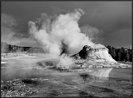
Castle Geyser in Yellowstone National Park (Photo Credit 9.7)
Scientists think a swelling magma reservoir 4 to 6 miles (7 to 10 kilometers) below the surface is driving the uplift. Fortunately, the surge doesn’t seem to herald an imminent catastrophe, Smith said. “At the beginning, we were concerned it could be leading up to an eruption,” said Smith, who co-authored a paper on the surge published in the December 3, 2010, edition of Geophysical Research Letters.
“But once we saw [the magma] was at a depth of 10 kilometers, we weren’t so concerned. If it had been at depths of 2 or 3 kilometers [1 or 2 miles], we’d have been a lot more concerned.” Studies of the surge, he added, may offer valuable clues about what’s going on in the volcano’s subterranean plumbing, which may eventually help scientists predict when Yellowstone’s next volcanic “burp” will break out.
Smith and colleagues at the U.S. Geological Survey (USGS) Yellowstone Volcano Observatory have been mapping the caldera’s rise and fall using tools such as global positioning systems (GPS) and interferometric synthetic aperture radar (InSAR), which gives ground-deformation measurements.
Ground deformation can suggest that magma is moving toward the surface before an eruption: The flanks of Mount St. Helens, for example, swelled dramatically in the months before its 1980 explosion. But there are also many examples, including the Yellowstone supervolcano, where it appears the ground has risen and fallen for thousands of years without an eruption.
According to current theory, Yellowstone’s magma reservoir is fed by a plume of hot rock surging upward from Earth’s mantle. When the amount of magma flowing into the chamber increases, the reservoir swells like a lung and the surface above expands upward. Models suggest that during the recent uplift, the reservoir was filling with 0.02 cubic miles (0.1 cubic kilometer) of magma a year. When the rate of increase slows, the theory goes, the magma likely moves off horizontally to solidify and cool, allowing the surface to settle back down.
Based on geologic evidence, Yellowstone has probably seen a continuous cycle of inflation and deflation during the past 15,000 years, and the cycle will likely continue, Smith said. Surveys show, for example, that the caldera rose some 7 inches (18 centimeters) between 1976 and 1984 before dropping back about 5.5 inches (14 centimeters) during the next decade.
“These calderas tend to go up and down, up and down,” he said. “But every once in a while they burp, creating hydrothermal explosions, earthquakes, or—ultimately—they can produce volcanic eruptions.”
Predicting when an eruption might occur is extremely difficult, in part because the fine details of what’s going on under Yellowstone are still undetermined. What’s more, continuous records of Yellowstone’s activity have been made only since the 1970s—a tiny slice of geologic time—making it hard to draw conclusions. “Clearly some deep source of magma feeds Yellowstone, and since Yellowstone has erupted in the recent geological past, we know that there is magma at shallower depths too,” said Dan Dzurisin, a Yellowstone expert with the USGS Cascades Volcano Observatory in Washington State.
“There has to be magma in the crust, or we wouldn’t have all the hydrothermal activity that we have,” Dzurisin added. “There is so much heat coming out of Yellowstone right now that if it wasn’t being reheated by magma, the whole system would have gone stone cold since the time of the last eruption 70,000 years ago.”
The large hydrothermal system just below Yellowstone’s surface, which produces many of the park’s top tourist attractions, may also play a role in ground swelling, Dzurisin said, though no one is sure to what extent. “Could it be that some uplift is caused not by new magma coming in but by the hydrothermal system sealing itself up and pressurizing?” he asked. “And then it subsides when it springs a leak and depressurizes? These details are difficult.”
Supervolcanoes of the World
1. Lake Toba, Sumatra, Indonesia—The 1,080-square-mile Toba caldera can be described as Yellowstone’s “big sister.” It erupted 74,000 years ago, triggering a global cold spell.
2. Long Valley, California—At 200 square miles, the Long Valley caldera’s most recent eruption was in Mono Lake, 250 years ago.
3. Lake Taupo, New Zealand—A massive eruption created Lake Taupo 26,500 years ago, when the caldera collapsed and filled up with water. The 485-square-mile caldera erupted again in the year A.D. 181.
4. Valles Caldera, New Mexico—The 175-square-mile Valles caldera last erupted 1.2 million years ago. Hot springs around it remain active.
5. Aira, Japan—On January 10, 1914, the Sakura-jima volcano, which forms part of the 150-square-mile Aira caldera, became active and caused hundreds of earthquakes. Two days later, it erupted with ash, steam, and lava.
And it’s not a matter of simply watching the ground rise and fall. Different areas may move in different directions and be interconnected in unknown ways, reflecting the as yet unmapped network of volcanic and hydrothermal plumbing. The roughly 3,000 earthquakes in Yellowstone each year may offer even more clues about the relationship between ground uplift and the magma chamber. For example, between December 26, 2008, and January 8, 2009, some 900 earthquakes occurred in the area around Yellowstone Lake.
This earthquake “swarm” may have helped to release pressure on the magma reservoir by allowing fluids to escape, and this may have slowed the rate of uplift, the University of Utah’s Smith said. “Big quakes [can have] a relationship to uplift and deformations caused by the intrusion of magma,” he said. “How those intrusions stress the adjacent faults, or how the faults might transmit stress to the magma system, is a really important new area of study.”
Overall, USGS’s Dzurisin added, “The story of Yellowstone deformation has gotten more complex as we’ve had better and better technologies to study it.”
Choppy, undulating clouds could be examples of the first new type of cloud to be recognized since 1951. Or so hopes Gavin Pretor-Pinney, founder of the Cloud Appreciation Society.
In 2005 British cloud enthusiast Gavin Pretor-Pinney said he began getting photos of “dramatic” and “weird” clouds that he didn’t know how to define. In 2009, he began preparing to propose the odd formations as a new cloud variety to the UN’s World Meteorological Organization, which classifies cloud types.
Pretor-Pinney jokingly calls it the “Jacques Cousteau cloud,” after its resemblance to a roiling ocean surface seen from below. But the cloud fan has proposed a “formal,” Latin name: Undulatus asperatus—roughly, “a very turbulent, violent, chaotic form of undulation,” explained Pretor-Pinney, author of the new Cloud Collector’s Handbook.
TRUTH:
A CLOUD CAN WEIGH MORE THAN A MILLION POUNDS.
Margaret LeMone, a cloud expert with the National Center for Atmospheric Research in Boulder, Colorado, said that she has taken photos of asperatus clouds intermittently throughout the past 30 years. It’s likely that the cloud will turn out to be a new variety, LeMone said. “Having a group of people enthusiastic about clouds can only help the field of meteorology,” she added.
Asked how such a striking cloud type could go unrecognized, Pretor-Pinney cites its rarity—and the proliferation and portability of digital cameras. “Technology has allowed us to have this new perspective on the sky.”
This apparently new class of cloud is still a mystery. But experts suspect asperatus clouds’ choppy undersides may be due to strong winds disturbing previously stable layers of warm and cold air. Asperatus clouds may spur the first new classification in the World Meteorological Organization’s International Cloud Atlas since the 1950s, Pretor-Pinney said.
“Even if you live in the middle of the city, the sky is the last wilderness you can look out on.”
Gavin Pretor-Pinney
cloud enthusiast and author of Cloud Collector’s Handbook
Since the last addition to the atlas, the emergence of satellite imagery has pushed meteorologists to take a much broader view on weather and focus less on small-scale cloud formations. But “the tide is turning back again,” in part because the humble cloud is seen as a “wild card” in climate-change prediction, Pretor-Pinney said.
LeMone agreed that clouds are a “big unknown” in climate change, mostly because climate-change models do not provide a high-enough resolution to determine what clouds’ impacts will be on a changing world.
Gavin Pretor-Pinney, who is proposing that asperatus clouds be officially recognized, said that clouds get a “bad rap.” “People complain about … having a cloud hanging over them, compared to someone having a sunny outlook on life,” said Pretor-Pinney. “To me, clouds are one of the most beautiful parts of nature.”
A team of geologists have solved the mystery behind the formation of giant crystals in a Mexican cave known as the “Sistine Chapel of crystals.”
Buried a thousand feet (300 meters) below Naica Mountain in the Chihuahuan Desert, the spectacular wonder was discovered by two miners excavating a new tunnel for the Industrias Peñoles company in 2000. They found a cave filled with some of the largest natural crystals ever found: translucent gypsum beams measuring up to 36 feet (11 meters) long and weighing up to 55 tons.
TRUTH:
INSIDE THE CAVE OF CRYSTALS, THE AVERAGE TEMPERATURE IS 122 DEGREES FAHRENHEIT, WITH ALMOST 100 PERCENT HUMIDITY.
“It’s a natural marvel,” said Juan Manuel García-Ruiz, of the University of Granada in Spain.
It took seven years for geologist García-Ruiz and a team of researchers to unlock the mystery of just how the minerals in Mexico’s Cueva de los Cristales (Cave of Crystals) achieved their monumental forms.
Massive beams of selenite dwarf an explorer in the Cave of Crystals. (Photo Credit 9.8)
To learn how the crystals grew to such gigantic sizes, García-Ruiz studied tiny pockets of fluid trapped inside. The crystals, he said, thrived because they were submerged in mineral-rich water with a very narrow, stable temperature range—around 136 degrees Fahrenheit (58 degrees Celsius). At this temperature the mineral anhydrite, which was abundant in the water, dissolved into gypsum, a soft mineral that can take the form of the crystals in the Naica cave.
The mining complex in Naica contains some of the world’s largest deposits of silver, zinc, and lead. In 1910, miners discovered another spectacular cavern beneath Naica.
Its walls studded with crystal “daggers,” the Cave of Swords is closer to the surface, at a depth of nearly 400 feet (120 meters). While there are more crystals in the upper cave, they are far smaller, typically about a yard (a meter) long.
The Cave of Crystals is a horseshoe-shaped cavity in limestone rock about 30 feet (10 meters) wide and 90 feet (30 meters) long. Its floor is covered in crystalline, perfectly faceted blocks. The huge crystal beams jut out from both the blocks and the floor. “There is no other place on the planet where the mineral world reveals itself in such beauty,” García-Ruiz said.
Looters, Beware
The Cave of Crystals’ stifling temperatures and the fact that it takes 20 minutes to drive to its entrance through a twisting mine shaft hasn’t prevented looters from trying to get a piece of the treasure. One of the crystals was found with a deep scar where someone tried, but failed, to cut through it. Subsequently, the cave has been supplied with a heavy steel door.
Volcanic activity that began about 26 million years ago created Naica Mountain and filled it with high-temperature anhydrite, which is the anhydrous—lacking water—form of gypsum. Anhydrite is stable above 136 degrees Fahrenheit (58 degrees Celsius). Below that temperature gypsum is the stable form.
When magma underneath the mountain cooled and the temperature dropped below 58 degrees Celsius, the anhydrite began to dissolve. The anhydrite slowly enriched the waters with sulfate and calcium molecules, which for millions of years have been deposited in the caves in the form of huge selenite gypsum crystals. “There is no limit to the size a crystal can reach,” García-Ruiz said.
But, he said, for the Cave of Crystals to have grown such gigantic crystals, it must have been kept just below the anhydrite-gypsum transition temperature for many hundreds of thousands of years. In the upper cave, by contrast, this transition temperature may have fallen much more rapidly, leading to the formation of smaller crystals.
TRUTH:
THE WORLD’S LARGEST KNOWN CRYSTAL IS 37.4 FEET LONG. THAT’S EIGHT TIMES TALLER THAN THE AVERAGE TEN-YEAR-OLD.
While the chance of this set of conditions occurring in other places in the world is remote, García-Ruiz expects that there are other caves and caverns at Naica containing similarly large crystals. “The caves containing larger crystals will be located in deeper levels with temperatures closer to, but no higher than, 58 degrees Celsius,” he said.
He has recommended to the mining company that the caves should be preserved.
The only reason humans can get into the caves today, however, is because the mining company’s pumping operations keep them clear of water. If the pumping is stopped, the caves will again be submerged and the crystals will start growing again, García-Ruiz said.
So what happens if—or when—the mine is closed?
“That’s an interesting question,” García-Ruiz said. “Should we continue to pump water to keep the cave available so future generations may admire the crystals? Or should we stop pumping and return the scenario to the natural origin, allowing the crystals to regrow?”
As sea temperatures have risen in recent decades, enormous sheets of a mucuslike material have begun forming more often, oozing into new regions, and lasting longer, a new Mediterranean Sea study says. And the blobs may be more than just unpleasant.
Beware of the blob—this time, it’s for real. Up to 124 miles (200 kilometers) long, the mucilages appear naturally, usually near Mediterranean coasts in the summer. The season’s warm weather makes seawater more stable, which facilitates the bonding of the organic matter that makes up the blobs. Now, due to warmer temperatures, the mucilages are forming in winter too—and lasting for months.
“The suit was impossible to wash totally, because it was covered by a layer of greenish slime.”
Serena Ford Umani
co-author of mucilage study, on the state of her wet suit after diving into the blob
Until now, the light-brown “mucus” was seen as mostly a nuisance, clogging fishing nets and covering swimmers with a sticky gel—newspapers from the 1800s show beachgoers holding their noses, according to study leader Roberto Danovaro, director of the Marine Science Department at the Polytechnic University of Marche in Italy.
But a study found that Mediterranean mucilages harbor bacteria and viruses, including potentially deadly E. coli, Danovaro said. Those pathogens threaten human swimmers as well as fish and other sea creatures, according to the report, published in the journal PloS One.
A mucilage begins as “marine snow”: clusters of mostly microscopic dead and living organic matter, including some life-forms visible to the naked eye—small crustaceans such as shrimp and copepods, for example. Over time, the snow picks up other tiny hitchhikers, looking for a meal or safety in numbers, and may grow into a mucilage.
The blobs were first identified in 1729 in the Mediterranean, where they’re most often seen. The seas relative stillness and shallowness make the water column more stable, providing ideal conditions for mucilage formation. For this study, Danovaro and colleagues studied historical reports of mucilage in the Mediterranean from 1950 to 2008. Outbreaks, they discovered, were more likely when sea-surface temperatures were warmer than average.
TRUTH:
MUCILAGES WERE FIRST IDENTIFIED IN THE MEDITERRANEAN IN 1729.
In 1991, Italian marine biologist Serena Fonda Umani swam alongside a mucilage—the mass is too dense to swim inside—in the Adriatic Sea, an arm of the Mediterranean. She remembers diving about 50 feet (15 meters) down when she got the sensation of a ghost floating over her—“sort of an alien experience.”
Umani, a co-author of the new study with Danovaro and Antonio Pusceddu, of the Polytechnic University of Marche, has also dived into marine snow—the mucilage’s precursor. She described it as being like swimming through a sugar solution. Out of the water, the dried “sugar” stiffened her hair and stuck to her wet suit. “The suit was impossible to wash totally, because it was covered by a layer of greenish slime,” said Umani, of Italy’s University of Trieste. “It was a nightmare.”
Few people would purposely swim into a mucilage, said Farooq Azam, a marine microbiologist at the University of California’s Scripps Institution of Oceanography. “If you were not familiar with this—and especially if you were familiar—you wouldn’t want to go near it,” said Azam, who was not involved in the new study. A giant odiferous blob drifting offshore is “certainly not the seascape that one goes to the beach [for],” Azam added.
Umani and colleagues sampled coastal waters and mucilage from the Adriatic in 2007. The study team discovered that the blobs are hot spots for viruses and bacteria, including the deadly E. coli. Study leader Danovaro said, “Now we see that … the release of pathogens from the mucilage can be potentially problematic” for human health.
Beach Bacteria
In 2005, the Clean Beaches Council, a Washington, D.C.-based advocacy group, issued a report that the sand at many U.S. beaches contains bacteria that indicate potentially unhealthy levels of fecal material. The indicator bacteria, which include a benign form of E. coli, pose little health risk to people, but still serve as warning signs that harmful fecal microorganisms may be present as well. The report is meant to raise awareness for beachgoers to “leave no trace” when visiting the beach and to wash up after playing in the sand.
Fish and other marine animals that have no choice but to swim with mucilages are most vulnerable to their disease-carrying bacteria, the study says. The noxious masses can also trap animals, coating their gills and suffocating them, Danovaro said. And the biggest blobs can sink to the bottom, acting like a huge blanket that smothers life on the seafloor.
Mucilages aren’t a concern for just the Mediterranean, Danovaro added. Recent studies tentatively suggest that mucus may be spreading throughout oceans from the North Sea to Australia, perhaps because of rising temperatures, he said.
“It’s a good example [of what will happen if] we don’t do something to stop climate warming,” Danovaro said. “There are consequences [if] we continue to deny the scientific evidence.”
Beyond warm temperatures, it’s still not exactly clear what drives the blobs’ formation, Scripps’ Azam pointed out. For instance, no one knows why the dead marine matter in the blobs doesn’t decompose. “It’s important we do find out” what’s driving the rise of the blobs, Azam said, “for the sake of the rest of the worlds’ oceans.”
Off the shores of Cancún, Mexico, stand hundreds of statues, a new underwater sculpture garden that doubles as an artificial reef.
More than 400 of the permanent sculptures have been installed in 2010 in the National Marine Park of Cancún, Isla Mujeres and Punta Nizuc as part of a major artwork called “The Silent Evolution.” The installation is the first endeavor of a new underwater museum called MUSA, or Museo Subacuático de Arte.
TRUTH:
THE SCULPTURES ARE MADE FROM CEMENT, SAND, MICROSILICA, FIBERGLASS, AND LIVE CORAL.
Created by Mexico-based British sculptor Jason deCaires Taylor, the Caribbean installation is intended to eventually cover more than 4,520 square feet (420 square meters), which would make it “one of the largest and most ambitious underwater attractions in the world,” according to a museum statement. Along with creator Taylor, a team of artists, builders, marine biologists, engineers, and scuba divers are working together to complete it.
In doing so, Taylor hopes the reefs, which are already stressed by marine pollution, warming waters, and overfishing, can catch a break from the approximately 750,000 tourists who visit local reefs each year. “That puts a lot of pressure on the existing reefs,” Taylor told National Geographic News. “So part of this project is to actually discharge those people away from the natural reefs and bring them to an area of artificial reefs.”
The sculptures are made of a special kind of marine cement that attracts the growth of corals, according to creator Taylor. That in turn encourages fish and other marine life to colonize the reef, he said.
“Already, I think there’re a thousand different fish living on them. There’re lobsters, there’re big schools of angelfish. And there’s a big coating of algae, which is one of the [first] things to settle.”
A Way to Recycle
Along the Atlantic coast from New Jersey to Georgia, subway cars—along with armored tanks, naval ships, tugboats, and a large number of concrete culverts—have been strategically dumped in the ocean to act as artificial reefs. Most of the mid-Atlantic ocean surface is featureless sand punctuated with mud splotches, so the artificial reefs help boost marine life and, by extension, keep recreational fishers happy.
The people in “The Silent Evolution” were created from live casts of a wide sample of people, most of them locals—including Lucky a Mexican carpenter; a 3-year-old boy, Santiago; and an 85-year-old nun, Rosario. Also depicted are an accountant, yoga instructor, and acrobat, among others.
“Sarah,” modeled after a U.K. linguistics professor, is the only “Silent Evolution” statue with a false lung, according to Taylor. Divers can either fill the lung by blowing bubbles into a hole on her back or using air from their tanks. The air then slowly escapes though the opening in her mouth.
The tight gathering of people is meant to illustrate “how we are all facing serious questions concerning our environment and our impact on the natural world,” according to a museum statement.
The sculptures were lowered into the waters off Cancún in late 2010. There, they sit in just 30 feet (9 meters) of water, which allows visitors in glass-bottomed boats to observe the artwork, according to a museum statement. Boatbound visitors can also see big schools offish above the statues, Taylor said. “If there’re any sorts of predators or any danger, [the fish] sort of drop below and then hide out in the [statues’] feet area.”
TRUTH:
UPON THE INSTALLATION’S COMPLETION, THE WEIGHT OF THE STATUES WILL TOTAL MORE THAN 180 TONS.
The builders of “The Silent Evolution” hope to usher in a new age of responsible tourism in the area, according to the museum. MUSA, the underwater museum, plans to add sculptures as funding becomes available. But “The Silent Evolution” won’t ever really be finished, since marine life will continue adding its own touches for centuries.
The cement figures will change in appearance in time as coral and other marine life takes over—all part of Taylor’s vision. “The manifestation of living organisms cohabiting and ingrained in our being is intended to remind us of our close dependency on nature and the respect we should afford it,” according to a museum statement.
Already the exhibition is drawing more divers, and area dive-tour providers are hoping the underwater museum boosts business and supports reef health, according to a museum statement. “This is a perfect balance where we are protecting the reef, where we are bringing the tourists into the natural area,” Roberto Diaz, president of both the Cancún Nautical Association and the museum, told National Geographic News.
“We are providing art to make it beautiful, and altogether [it] will help.”
A moss spreading throughout the Hawaiian Islands appears to be an ancient clone that has copied itself for some 50,000 years—and may be one of the oldest multicellular organisms on Earth, a new study suggests.
Once only found on Hawaii’s Big Island, an ancient moss has begun to appear throughout the Hawaiian Islands. Studies show that this little green organism has been cloning itself for around 50,000 years.
The peat moss Sphagnum palustre is found throughout the Northern Hemisphere, but the moss living in Hawaii appears to reproduce only through cloning. All the moss populations sampled share a rare genetic marker, which suggests they’re descended from a single founder plant that was carried via wind to Hawaii tens of thousands of years ago.
Surprisingly Diverse
A genetic analysis of the S. palustre moss in Hawaii reveals surprising diversity, which challenges the widespread assumption that clones are genetically uninteresting because they can’t swap DNA through sex.
Study co-author Eric Karlin, a plant ecologist at Ramapo College in New Jersey, wrote, “You would expect one founding plant to have this rare trait. However, it is unlikely that there were many founding plants with each one having the same rare trait.”
Fossilized S. palustre moss remains have been found in 23,900-year-old peat near the summit of Kohala Mountain on Big Island (Hawaii). From these remains, Karlin and colleagues inferred that the moss had been in Hawaii at least that long, and perhaps longer.
The team analyzed the genetic diversity of the current population of moss on the island and determined a mutation rate. Using this rate, they estimated how long it took for the different moss populations to get to where they are genetically—about 50,000 years. The analysis also revealed surprising diversity—challenging the popular assumption that clones are genetically drab because they can’t swap DNA through sex.
“They’re not identical because mutations are always occurring,” Karlin said.
TRUTH:
SPHAGNUM IS A GREEK NAME FOR A PLANT HISTORIANS HAVEN’T YET IDENTIFIED, MOTFISALATIN WORD MEANING “MARSHY.” OR “GROWING IN A MARSH.”
Given the absence of sex, the moss has been likely “trapped” on the Kohala summit, Karlin said. Sexual reproduction—which creates airborne spores—would be required for the plant to move elsewhere. But people have also lent a helping—though unwitting—hand in the moss’s spread.
In the past century, people have used the moss for packing material, in doing so moving the species across Big Island as well as on the island of Oahu. “The peat moss has had explosive growth where it was introduced, especially on Oahu,” Karlin said.
The moss’s success comes at the cost of other local plants, however. “It’s a problem,” he said. “The moss completely changes the ecology of the ground layer. Instead of there being soil, there is a solid carpet of moss, and the seeds of many of the local plants don’t grow in the moss layer.”
A massive cave uncovered in a remote Vietnamese jungle is the largest single cave passage yet found.
In 2009, a team of explorers measured the truly gigantic Son Doong cave to determine that it was indeed the world’s biggest single cave passage. The caves entrance had been discovered years earlier, but no one knew just how big a find it would turn out to be.
At 262-by-262 feet (80-by-80 meters) in most places, the Son Doong cave beats out the previous world-record holder, Deer Cave in the Malaysian section of the island of Borneo. Deer Cave is no less than 300-by-300 feet (91-by-91 meters), but it’s only about a mile (1.6 kilometers) long. By contrast, explorers walked 2.8 miles (4.5 kilometers) into Son Doong, in Phong Nha-Ke Bang National Park, before being blocked by seasonal floodwaters—and they think that the passage is even longer.
TRUTH:
A JUNGLE GROWS INSIDE VIETNAM’S SON DOONG CAVE.
In addition, for a couple of miles Son Doong reaches more than 460-by-460 feet (140-by-140 meters), said Adam Spillane, a member of the British Cave Research Association expedition that explored the massive cavern. Spillane was in the first of two groups to enter the cave. His team followed the passage as far as a 46-foot-high (14-meter-high) wall.
A rock formation shines beneath a skylight in the Son Doong cave. (Photo Credit 9.9)
“The second team that went in got flooded out,” he said. “We’re going back next year to climb that wall and explore the cave further.”
A local farmer, who had found the entrance to the Son Doong cave several years before, led the joint British-Vietnamese expedition team to the cavern in April 2009. The team found an underground river running through the first 1.6 miles (2.5 kilometers) of the limestone cavern, as well as giant stalagmites more than 230 feet (70 meters) high.
The explorers surveyed Son Doong’s size using laser-based measuring devices. Such modern technology allows caves to be measured to the nearest millimeter, said Andy Eavis, president of the International Union of Speleology, the world caving authority, based in France. “With these laser-measuring devices, the cave sizes are dead accurate,” he said. “It tends to make the caves smaller, because years ago we were estimating, and we tended to overestimate.”
TRUTH:
THE SON DOONG CAVE BELONGS TO A NETWORK OF ABOUT 150 CAVES, MANY OF WHICH HAVE YET TO BE SURVEYED, IN THE ANNAMITE MOUNTAINS.
Eavis, who wasn’t involved in the survey, agreed that the new findings confirm Son Doong’s record status—despite the fact that he had discovered Borneo’s now demoted Deer Cave. “This one in Vietnam is bigger,” Eavis conceded.
However, the British caver can still claim the discovery of the world’s largest cave chamber, Sarawak Chamber, also in Borneo. “That is so large it may not actually be beaten,” he said. “It’s three times the size of Wembley Stadium” in London.
Son Doong had somehow escaped detection during previous British caving expeditions to the region, which is rich in limestone grottos. “The terrain in that area of Vietnam is very difficult,” said expedition team member Spillane.
“The cave is very far out of the way. It’s totally covered in jungle, and you can’t see anything on Google Earth,” he added, referring to the free 3-D globe software.
“You’ve got to be very close to the cave to find it,” Spillane said. “Certainly, on previous expeditions, people have passed within a few hundred meters of the entrance without finding it.”
“Couldn’t have done it without him … It took three expeditions to find Hang Son Doong. Khanh had found the entrance as a boy but had forgotten where it was. He only found it again last year.”
Howard Limbert
British caver, on the help provided by a villager named Ho Khanh in discovering Son Doong
The team was told that local people had known of the cave but were too scared to delve inside. “It has a very loud draft and you can hear the river from the cave entrance, so it is very noisy and intimidating,” Spillane said.
Of more concern to the caving team were the poisonous centipedes that live in Son Doong. The explorers also spotted monkeys entering through the roof of the cave to feed on snails, according to Spillane.
“There are a couple of skylights about 300 meters [985 feet]] above,” he said. “The monkeys are obviously able to climb in and out.” Planned return visits to the cave include bringing a biologist along to survey the cave’s subterranean wildlife.
Eavis, of the International Union of Speleology, added that there are almost certainly bigger cave passages awaiting discovery around the world. “That’s the fantastic thing about caving,” he said. Satellite images hint, for example, that caves even larger than Son Doong lie deep in the Amazon rain forest, he said.
A rose by any other name would smell as sweet. And a new species of Amorphophallus—the genus that includes the “corpse flower — still smells like rotting meat and feces.
Discovered on an island off the coast of Madagascar, the newfound plant grows up to 5 feet (1.5 meters) high and blooms once a year with a “really foul” stench, according to discoverer Greg Wahlert, a postdoctoral researcher in botany at the University of Utah.

The plant smells of rotting meat. (Photo Credit 9.10)
Lynn Bohs, a biology professor in the same lab as Wahlert, described the smell in a statement as a combination of “rotting roadkill” and a “Porta Potti.” The new flower adds to the roughly 170 species in the Amorphophallus genus, which means “misshapen penis” in Greek after the phallic shape of the plants’ flowers.
Wahlert discovered the new species—named A perrieri—in full bloom while collecting violets in two remote islands northwest of Madagascar in 2006 and 2007. Suspecting the plant might be a new species, he brought back samples and began cultivating them. After consulting with an Amorphophallus expert in the Netherlands, he confirmed that A. perrieri was a previously undescribed species.
Because A. perrieri is dormant for much of the year, Wahlert’s discovery is a case of good timing. For months out of the year, there’s little rain in that part of Madagascar, so the plants remain dormant underground. “These things are growing out of the most miserable soil,” said Wahlert, who is working on a scientific paper about the species.
TRUTH:
CORPSE FLOWERS, MEMBERS OF THE AMORPHOPHALLUS GENUS, ATTRACT NOCTURNAL INSECTS SUCH AS BEETLES AND FLIES THAT USUALLY LAY EGGS IN ROTTING FLESH.
The specimen he is cultivating in the university’s greenhouse shot up its flower in just two weeks. If Wahlert had been visiting the islands at a different time, “I could have very easily missed it.”
All Amorphophallus species emit smells to attract flies and other insects. Though a few emit more pleasant aromas, such as chocolate or spices, most smell terrible to human noses, Wahlert said. “You can imagine in Africa, where big game will die and rot in the sun … that’s what they smell like,” Wahlert said.
Despite the stench, he added, “I’m glad I got a stinky one. It’s fascinating to me.”

