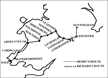
The approach routes of the two armies. The redating of Tudor’s advance by Griffiths and Thomas, in 1985, showed he progressed more slowly than had been thought. In this revised chronology, Henry only enters England at Shrewsbury on 17 August, two days later than commonly accepted. Tudor was pressed for time in the last phase of his march. This factor becomes significant when we consider the alternative battle site, eight miles further west. In this scenario, Henry would have less distance to cover.
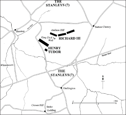
The traditional battle site, with Richard III on Ambion Hill and Henry Tudor approaching from the west. The flanking manoeuvre described by Polydore Vergil is almost impossible to achieve and the position of the Stanleys unknowable. The name ‘King Dick’s Well’ dates from the late eighteenth century.
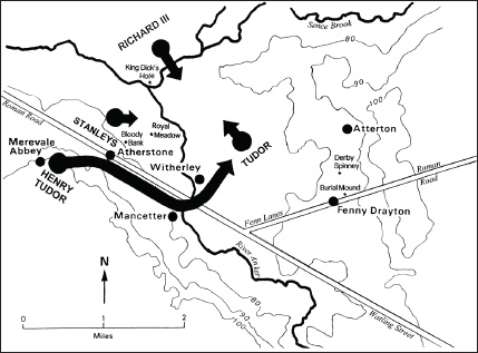
The proposed alternative battle site. The map shows (i) the possible start positions of the rival armies on the morning of 22 August 1485; (ii) Henry Tudor’s flanking manoeuvre and final deployment; (iii) the position of the Stanley forces in Atherstone, mid-way between the two armies; (iv) the parishes named in Henry VII’s compensation grant (Mancetter, Witherley, Atterton and Fenny Drayton). The clusters of place-name evidence might suggest the clash of the vanguards took place north of Atherstone, in the vicinity of Royal Meadow and Bloody Bank, and that Richard’s engagement with Tudor occurred further east, with the fighting spilling into the parishes of Fenny Drayton and Atterton, and culminating close to Derby Spinney and the burial mound. (Modern roads have been omitted).