SOPCHOPPY RIVER
The Sopchoppy River drains from a large swamp south of Lake Talquin and flows for 50 miles to its confluence with the Ochlockonee at Ochlockonee Bay. Lying almost completely within the boundaries of the Apalachicola National Forest, it is an unusually remote and clean river. Sopchoppy is a Creek word said to mean “long, twisted stream,” an apt description of this beautiful waterway. In addition to its many twists and turns, the Sopchoppy is noted for extensive and very unique cypress formations, high limestone banks, and an overall fast current.
Highly dependent on local rainfall for its flow, the Sopchoppy can be either low stretches connecting deeper pools during dry periods or a rushing 10-foot channel after heavy rains. In either event, the sharp bends and presence of cypress knees in the water can present a challenge to the canoeist. The riverbed is primarily sand with some rock crevices; the water is a clear, but highly colored, tannic red. The high banks are occasionally broken by white sandbars suitable for picnicking or camping. Also, the Florida Trail parallels the Sopchoppy in places.
Of special interest on the Sopchoppy is the Bradwell Bay Wilderness. A virtually undisturbed scenic area, it escaped the lumbering craze of the early 20th century and harbors a number of award-winning trees. The first 10 canoeable miles of the river flow through the wilderness. There are also 17 archaeologically valuable sites along the river that are said to be the only models of aboriginal usage of the flatwoods in northwest Florida. A number of species—including the red-cockaded woodpecker, Southern bald eagle, and black bear—make their homes in the area.
Vegetation is dense along the banks and includes loblolly pine forests, pine–palmetto flatwoods, cypress, titi, and other trees indigenous to the area. The steep limestone banks are covered with mosses and ferns, and in the spring wild azaleas provide a canopy of pink bloom.
MAPS: APALACHICOLA NATIONAL FOREST MAP, BRADWELL BAY, CRAWFORDVILLE WEST, SOPCHOPPY, SANBORN (USGS)
A FH 13 to Sopchoppy River Park
| Class | I–I+ | |
| Length | 26 | |
| Time | Varies | |
| Gauge | Web | |
| Level | N/A | |
| Gradient | 1.6 | |
| Scenery | A+ |
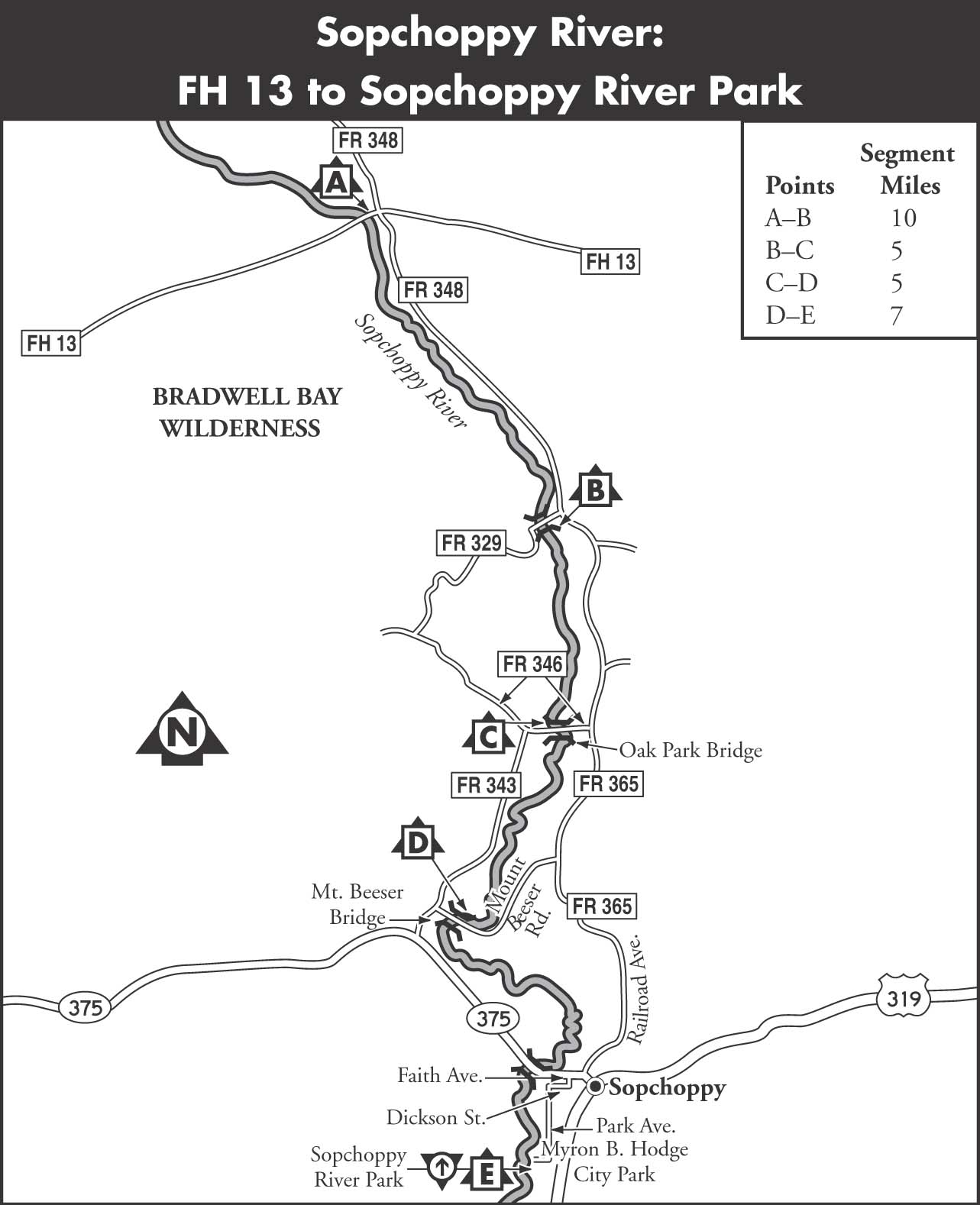
DESCRIPTION Runs on the Sopchoppy River can be broken into varied segments as there are numerous accesses. The upper river begins at the most southern edge of the Grand Bay Swamp, whose runoff forms the river. It is said to be possible to canoe one bridge farther upstream, but high water and a lot of bushwhacking are required. The river is clearly defined at the Forest Highway 13 bridge, where it enters the Bradwell Bay Wilderness, but fingers off into a swampy area for about 0.5 miles downstream. Despite the swampy terrain, the current is easily detectable and will lead to a well-defined channel with banks from 1 to 3 feet high.
Very sharp twists and turns in a narrow streambed characterize this part of the river. Cypress knees and the remains of downed trees and stumps contribute to the obstructions that must be avoided. The constant curves and swift water leave little opportunity to scout as immediate decisions are required in maneuvering. This section of the river should only be run at higher water. It is 10 miles from the FH 13 bridge to FR 329, where it leaves the wilderness.
Starting at FR 329, the Middle Sopchoppy is a very popular section of river for canoeing. It is noted for the wide diversity of beautiful and unique cypress formations. In addition to a multitude of knees of all sizes and shapes, there are long, flowing banks of cypress wood, connecting groups of knees that resemble entwined serpents, monsters, gargoyles, or whatever the active imagination can envision.
The sharp bends in the river are frequently obstructed by masses of cypress knees resulting in small rapids and falls that require fast maneuvering. There are several small sandbars in this section that are pleasant for lunching, camping, or sunbathing. It is 5 miles from the FR 329 bridge to the FR 346 bridge, Oak Park Bridge. The old Oak Park Bridge was a quaint and rustic wooden structure, which has now been replaced by a concrete bridge. Access is on the northwest side of the bridge.
From just above the Oak Park Bridge, the river begins to widen and the curves become gentler. High, limestone banks become evident, and there are several small islands that narrow the channels of the river. The vertical banks act as a watershed and in warm weather produce a cooling effect. In the winter they may be dripping with icicles. The river is deeper and easier to negotiate in this section but still requires some skill. Just before the Mount Beeser Bridge, the river leaves the national forest, and houses and other forms of encroachment appear. Small motorboats may also be seen near the end of this section. It is 5 miles from the Oak Park Bridge to the Mount Beeser Bridge.

Below the Mount Beeser Bridge, the Sopchoppy River becomes deeper, slower, and increasingly populated beyond this point. It moves from the swamps and upland hardwoods to a marshier, coastal appearance. It is 6 miles from the Mount Beeser Bridge to FL 375. However, this access is closed and paddlers should continue another mile to the Sopchoppy River Park, on the left. The park has a boat landing, picnic area, and campground. It is possible to continue to paddle on the Sopchoppy to its confluence with the Ochlockonee. It becomes increasingly broad and tidal, however, and is heavily used by motorboats.
SHUTTLE To reach the uppermost put-in from US 319 in Sopchoppy, take Rose Street, FL 375, west just a short distance to Railroad Avenue, FR 365. Turn right and head north on FR 365 to FR 348. Follow FR 348 to FH 13. Turn left on FH 13 and follow it a short distance to the bridge over the Sopchoppy River. Access is on the northeast side of the bridge. To reach the lowermost takeout from US 319 in Sopchoppy, take Rose Street, FL 375, west to Faith Avenue. Turn left on Faith Avenue and follow it one block to Dickson Street. Turn right on Dickson Street to reach Park Avenue. Turn left on Park Avenue and follow it to Myron B. Hodge City Park, on the right, and a boat launch.
GAUGE Web. A helpful gauge to determine average river levels for this section of the river is Sopchoppy River near Sopchoppy, Florida.
