ST. MARKS RIVER
The St. Marks River flows through swampy terrain with a preponderance of cypress, magnolia, palm, and other lowland vegetation. The color of this clear, blue-green river results from its limestone bottom, and it has a variety of waterweeds above and below the surface. The current is mild, but it is possible to paddle upstream easily.
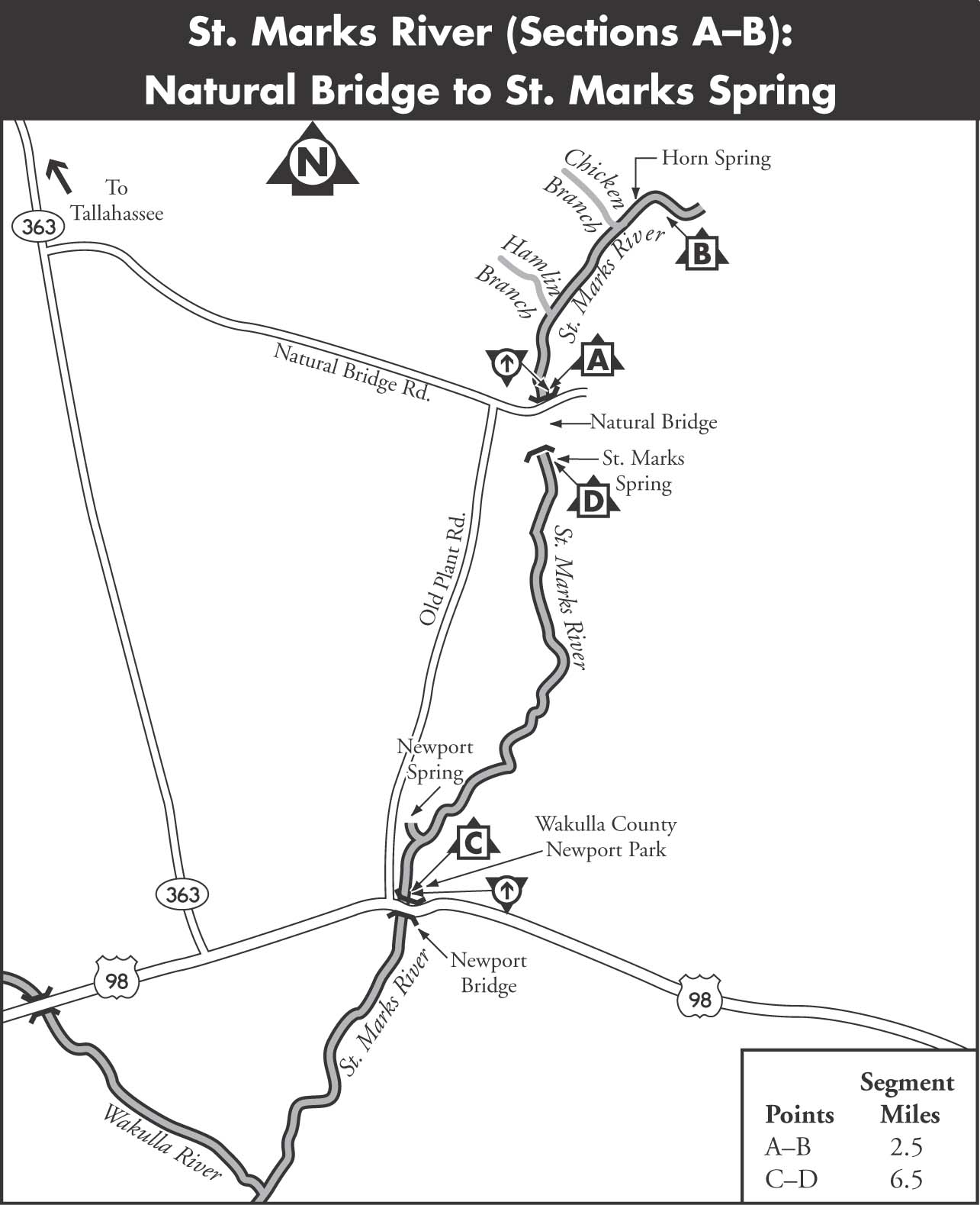
A tiny, swamp-lined stream meandering from a series of ponds north of US 90 is ambitiously named the St. Marks River, but it is not until the advent of the waters from Horn Spring that it becomes a canoeable stream. Then, just 2.5 miles later, it goes underground to form the famous Natural Bridge of historical repute. The river resumes with St. Marks Spring and flows some 11 miles to its confluence with the Wakulla and 3 miles on to the Gulf of Mexico.
A small state park is located at the Natural Bridge. On this site, Confederate militia repulsed Union forces on March 6, 1865, and prevented the capture of Tallahassee, the only Southern capital east of the Mississippi not taken in the Civil War.
There are several springs in the area of the Natural Bridge that are probably reoccurrences of the St. Marks River. These include Natural Bridge Spring and at least four springs in the Rhodes Springs group. They rise in an area that has a dense growth of vegetation, swamp, and karst features, such as sinkholes and solution tubes. The river does not rise as a well-defined riverbed until about 0.75 miles south of FL 260 at St. Marks Springs. This area is closed to public access.
MAPS: WOODVILLE, ST. MARKS (USGS)
A Natural Bridge to Horn Spring
| Class | I | |
| Length | 2.5 each way | |
| Time | 3.5 | |
| Gauge | Visual | |
| Level | Spring fed | |
| Gradient | 0.5 | |
| Scenery | A |
DESCRIPTION Although this section of the St. Marks River is short and the access roads to Horn Spring are closed and posted, it is of paddling interest because of the deep hardwood forest, swampy terrain, and unusually large cypress trees present along the banks. A trip on this section of the St. Marks requires a paddle upstream from the Natural Bridge and a paddle back, for a trip totaling 5 miles. It is a pleasant canoeing experience in a pocket of wilderness.
Horn Spring actually consists of two springs. The larger is 75 feet in diameter and 30 feet deep. When the sediment is undisturbed, it is a clear, green color. The smaller spring, 200 feet north, is only 30 feet in diameter. The two join to flow about 350 feet downstream into the St. Marks River.
Shortly below the influx of the spring runs, Chicken Branch enters the river from the west. Myriad unnamed seeping springs and small creeks lace the swamps beside the river. Some large cypress trees still stand in this area as well as magnolias, palms, and other vegetation.
SHUTTLE To reach the put-in/takeout from Tallahassee, take FL 363 south to Natural Bridge Road. Turn left on Natural Bridge Road and follow it to Natural Bridge Battlefield Historic State Park. The put-in is on the left just before a bridge as the road turns to sand.
GAUGE Visual. Horn Spring feeds this section, keeping it paddleable year-round.
B Newport Bridge to St. Marks Spring
| Class | I | |
| Length | 6.5 each way | |
| Time | 3 | |
| Gauge | Visual | |
| Level | Spring fed | |
| Gradient | 1 | |
| Scenery | B |
DESCRIPTION The property south of Natural Bridge Battlefield Historic State Park is privately owned, and there is no public access to St. Marks Spring or the rise of the St. Marks River. Therefore, enjoying this section requires an out-and-back paddle. It is possible to paddle upstream from the Newport Bridge. However, it is a round-trip of about 13 miles.
The river from St. Marks Spring to Newport Bridge is wide and has a lively current near the headspring, but becomes narrower and slower within the first mile. It is a very clear and beautiful waterway with intermittent swamp and highland banks. About 1 mile above Newport, the run from Newport Spring, formerly called Brewer Sulphur Spring, enters from the west bank. It is characterized by its highly pungent odor of sulfur.
The confluence of the St. Marks with the Wakulla River is 5 miles below the Newport Bridge and is frequented by motorboats and is generally unappealing to paddlers.
SHUTTLE To reach the put-in/takeout from Tallahassee, take FL 363 south to US 98. Turn left and take US 98 east to the Newport Bridge over the Wakulla River and Wakulla County Newport Park. The park and boat launch are on the east side of the river.
GAUGE Visual. This part of the St. Marks is fed by St. Marks Spring and is paddleable year-round.