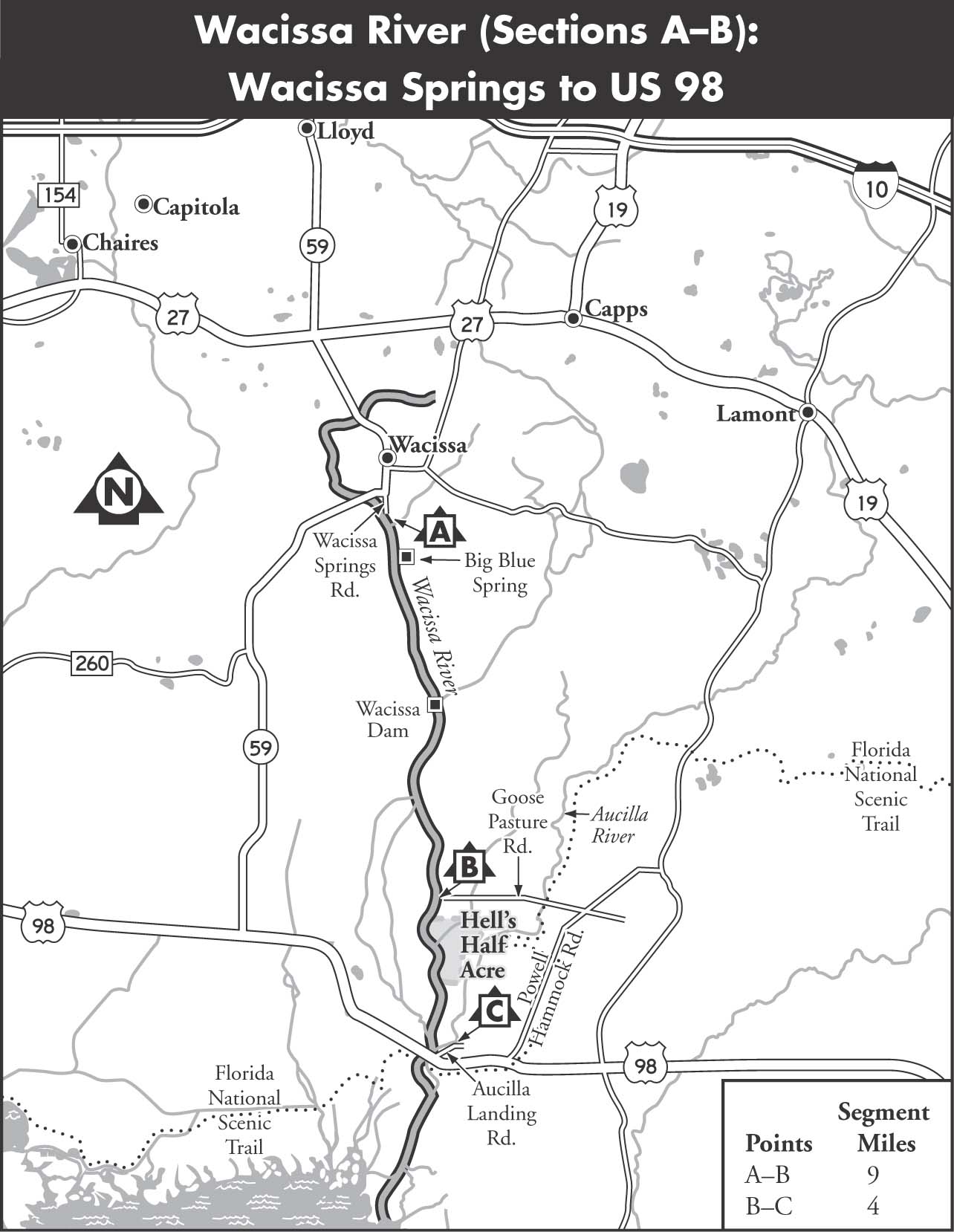
WACISSA RIVER
The Wacissa is fed by 12 first-magnitude springs. The adjoining area, densely forested with cypress, oak, and pine, is generally so swampy that access to most of the springs is only possible by boat. The river is very broad and flat for the first 5 miles below the headspring but narrows below Wacissa Dam. Less than 2 miles above a recreation area, Goose Pasture, the river again broadens and continues wide for another 0.5 miles. This is not truly the river, however, and the water soon begins to run off into the Western Sloughs.
The real Wacissa flows to the extreme west opposite Goose Pasture and eventually into the Slave Canal, built shortly after 1831 to connect the Wacissa and Aucilla rivers, providing a waterway to the Gulf of Mexico for the transport of cotton. The two rivers join just above US 98, and the Aucilla, having just popped up again at Nutall Rise, continues to the Gulf. Most paddlers end their trip at US 98.
MAPS: WACISSA, NUTALL RISE (USGS)
A Wacissa Springs to Goose Pasture
| Class | I | |
| Length | 9 | |
| Time | 4 | |
| Gauge | Visual | |
| Level | Spring fed | |
| Gradient | 2 | |
| Scenery | A |
DESCRIPTION Many paddlers do not go downriver on the Wacissa, but spend a pleasant day or afternoon paddling around the springs’ area. The 12 named springs are scattered along the upper 2 miles of the river. Big Blue Spring, about 1 mile downriver on the east bank, is one of the most popular of the group. The pool is 120 feet in diameter and 45 feet deep over the vent. The limestone bottom is cavernous, and the spring flows from several ledges on the northwest side of the vent.
Cedar Island is 3 miles below the headspring and marks the end of the spring area. Paddlers who plan to paddle back upstream to Wacissa probably should not progress beyond this point. There is a small cleared area on the island, good for lunch breaks and possible overnight camping for one or two tents.
The Wacissa Dam, the site of an old narrow-gauge railroad, offers a swift chute that poses no hazard for the paddler. Shortly below the dam, the Wacissa narrows and becomes interspersed with a number of low islands and hammocks, which divide the river into small channels. This area is not large, and if one chooses the wrong way, it is a simple matter to back up and start over. Just more than a mile above Goose Pasture, the river widens again into a long, grassy area. For a mile above this area the river is canopied and swift, and it may have some downed trees to pull over.
SHUTTLE To reach the put-in from Newport, take US 98 east to the intersection with FL 59. Turn left, north, on FL 59, and follow it to Wacissa Springs Road. Turn right on Wacissa Springs Road and follow it until it dead-ends at a boat ramp. To reach the takeout from Newport, take US 98 east beyond the bridge over the Aucilla River. Turn left on Powell Hammock Road. Keep north on Powell Hammock Road to Goose Pasture Road (watch for signs indicating Goose Pasture Recreation Area). Turn left on Goose Pasture Road and follow it to a dead end at Goose Pasture Recreation Area.
GAUGE Visual. The Wacissa is a spring-fed river and is floatable year-round.
A Goose Pasture to Aucilla River at US 98
| Class | I | |
| Length | 4 | |
| Time | 2 | |
| Gauge | Visual | |
| Level | Spring fed | |
| Gradient | 2 | |
| Scenery | A+ |
DESCRIPTION When leaving Goose Pasture, paddle to the far west side of the river. Follow the current through stands of wild rice down a narrow waterway and through a swampy area about 0.5 miles. A channel 25 to 30 feet wide will emerge; continue on it about 1 mile. Begin watching for large cypresses spaced along the left bank as the river widens. There will be a couple of small sloughs on the right, but keep paddling and watch for red rectangles painted on the trees on river right. Also watch for a small channel on the right: the Slave Canal. Cypresses and other hardwoods canopy the stream; you’ll likely encounter alligators, turtles, and water birds. Watch for overhead and underwater log obstructions.
Toward the end of the canal, the current slackens and the water deepens. Upon reaching the Aucilla, head upstream a few hundred yards to the boat landing on the river. The point where the Wacissa and Aucilla meet is easily recognized, as strong current flows past the Slave Canal from the east. If you reach the US 98 bridge, you’ve gone too far.
SHUTTLE To reach the put-in from Newport, take US 98 east to Powell Hammock Road. Turn left (north) on Powell Hammock Road, and head toward Goose Pasture Road (watch for signs indicating Goose Pasture Recreation Area). Turn left on Goose Pasture Road and follow it to the dead end at Goose Pasture Recreation Area. To reach the takeout from Newport, take US 98 east beyond the bridge over the Aucilla River. Turn left on Aucilla Landing Road, the first road east of the bridge, to reach a public boat ramp.
GAUGE Visual. The Wacissa is a spring-fed river and is floatable year-round.