WEKIVA RIVER AND ROCK SPRINGS RUN
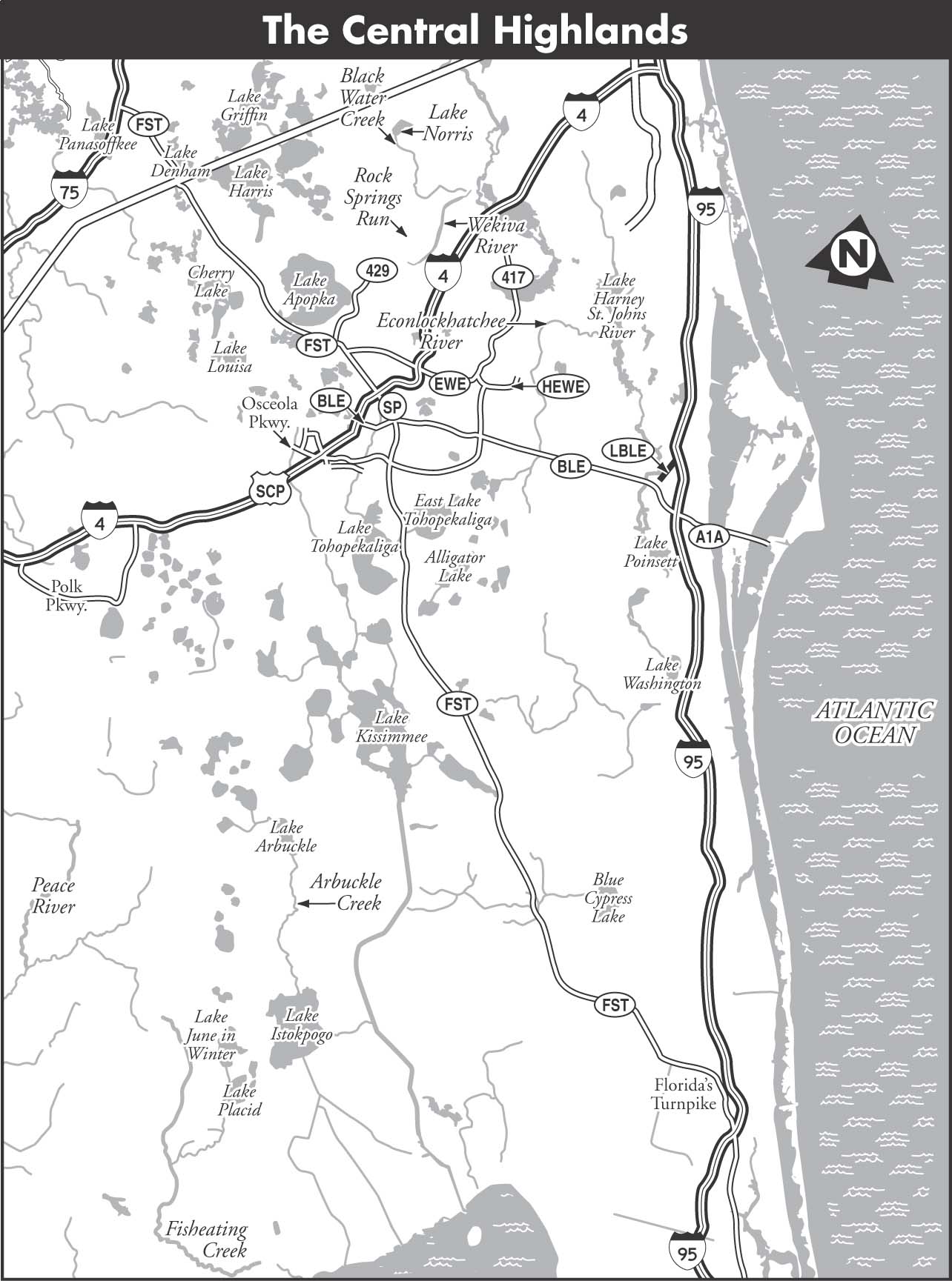
The Wekiva River in Orange County begins at Wekiva Springs State Park and flows north for 15 miles to the St. Johns River. Rock Springs is located 7 miles to the northwest, near Apopka, and flows southeast into the Wekiva River about 0.5 miles below Wekiva Springs. Both of these streams are very popular, located in a large metropolitan area and likely to be crowded during the warm months and on weekends. They are beautiful crystalline waterways, however, and have maintained a surprising degree of remoteness and freedom from encroachment considering their location. The lower portion of the Wekiva River is not recommended—as one nears the St. Johns River, the Wekiva becomes very broad and developed. To avoid paddling into a potentially windy and unpleasant experience on the St. Johns, most paddlers prefer to take out about a mile below the FL 46 bridge at a state-owned canoe launch.
The terrain on both Wekiva River and Rock Springs Run is a fine example of semitropical Florida wetlands and swamp. Cabbage palm, cypress, and other lowland trees abound, as well as other hardwoods that frequently canopy the waterway. It is truly an oasis amid ever-expanding greater Orlando.
MAPS: SORRENTO, SANFORD SW, FOREST CITY (USGS)
A Kings Landing to Wekiva Marina
| Class | I | |
| Length | 8 | |
| Time | 4 | |
| Gauge | Visual | |
| Level | Spring fed | |
| Gradient | 1.2 | |
| Scenery | A |
DESCRIPTION After paddling down a small canal from King’s Landing to the Rock Springs Run, paddlers enter a deep channel between lily pads and water reeds. The waterway itself is 30 to 40 feet wide but the navigable channel is only 10 to 15 feet across. Bring your short kayak or a canoe to negotiate the twists and turns on Rock Springs Run. Also, try to avoid summer weekends or you will be negotiating between other paddlers and tubers.
The first 4 miles of this paddle trail are among the most beautiful examples of lowland hardwoods and clear, green water of any stream in Florida. Tall trees with slender trunks form a complete canopy over the river in many places. Following this section, the river widens to 50 feet and then up to 100 feet in sections. It is shallower, and white sand can be glimpsed between the waterweeds on the bottom. Some 3 miles farther downstream, the river narrows again to 20 to 30 feet and becomes deeper. The sandy bottom is still in evidence and the canopy of hardwoods resumes.
At the confluence of the Wekiva River, canoeists may turn right and paddle up to the entrance to Wekiva Spring. This is the location of Wekiva Springs State Park, which has camping and canoe launching facilities. There is considerable current in the Wekiva River, but it is only 0.5 miles to the spring and well worth the effort.
Shortly below the confluence of the Wekiva River with the Rock Springs Run is the Wekiva Marina. This is a privately owned public-access facility with canoe rentals, a restaurant, store, and dock.
SHUTTLE To reach the takeout from Apopka, drive north on FL 435 to East Welch Road. Turn right on East Welch Road and follow it to Wekiva Springs Road to reach Miami Springs–Hunt Club Road. Turn left on Miami Springs–Hunt Club Road to reach Wekiva Marina. To reach the put-in, backtrack to FL 435, then turn right, north, on FL 435, to East Kelly Park Road. Turn right on East Kelly Park Road; continue for 0.125 miles and turn left on Baptist Camp Road. Continue north for less than a mile to King’s Landing. There is a small fee for launching.
GAUGE Visual. Rock Springs Run is spring fed and runnable year-round.
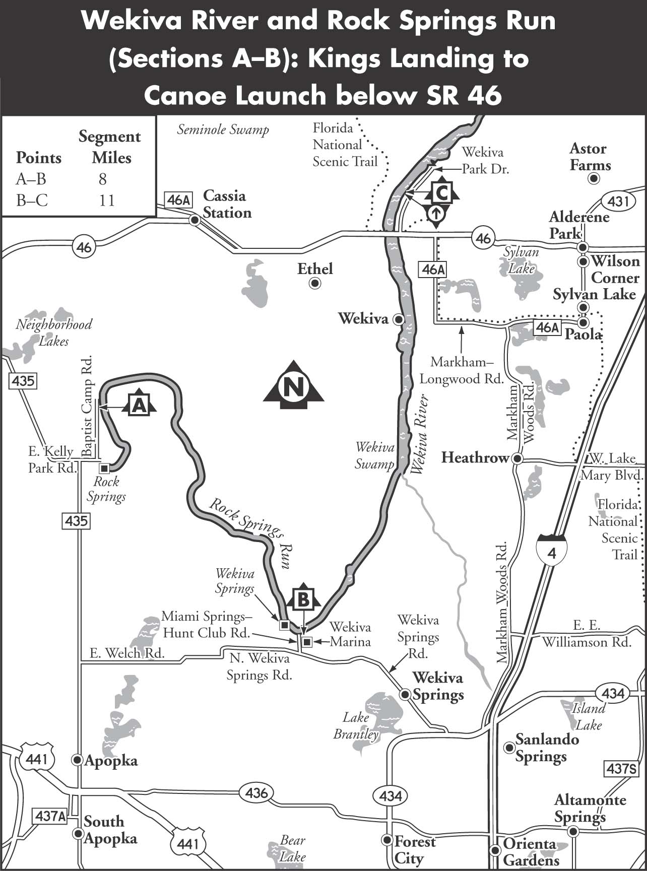
B Wekiva Marina to Canoe Launch below FL 46
| Class | I | |
| Length | 11 | |
| Time | 6 | |
| Gauge | Visual, Web | |
| Level | Spring fed | |
| Gradient | 0.9 | |
| Scenery | B |
DESCRIPTION After leaving the marina, the river turns north. It varies from 50 to 150 feet wide, dividing around islands. The Little Wekiva River enters from the right 3 miles downstream. A railroad trestle appears another 5 miles downstream.
The river widens dramatically just below the trestle to over 300 feet and resembles a small lake of grass and reeds. In this area, a canal on the left bank leads to a tourist attraction called Wekiva Falls. This facility has canoe rentals, camping, and a small riverboat that tours up the Wekiva for a mile or so. It offers takeout service for a fee. This shallow, grassy area continues to FL 46.
A free takeout on state-owned property is on the right-hand bank about a mile below FL 46 and is the best place to end your run on the Wekiva, unless you plan to paddle down to and across the St. Johns River at Debary (off High Banks Road in Volusia County).
SHUTTLE To reach the put-in from Exit 94 on Interstate 4, take FL 434 west to Wekiva Springs Road. Turn right on Wekiva Springs Road and follow it to a stoplight at Miami Springs–Hunt Club Road. Turn right on Miami Springs–Hunt Club Road to reach Wekiva Marina. To reach the takeout, backtrack to I-4 and turn left, north, on Markham Woods Road to reach Markham–Longwood Road. Turn left on Markham–Longwood Road and follow it to FL 46. Turn left on FL 46 and follow it just a short distance to Wekiva Park Drive. Turn right on Wekiva Park Drive and follow it about a mile to a state-owned canoe launch, on the left.
GAUGE Visual, Web. Wekiva River is spring fed and runnable year-round. The USGS gauge helpful in determining flow rates for any given day is Wekiva River near Sanford, Florida.