Chapter 2
The Shannon Basin: Structural Setting and Evolution
JOHN GRAHAM
2.1 Introduction
During the mid-Carboniferous, around 330 million years ago, the area around the modern Shannon Estuary of western Ireland provided significant accommodation for sediments that are now visible in spectacular coastal exposures. This depositional basin has been referred to as the Shannon Trough, the Shannon Basin, the Clare Basin and the Western Irish Namurian Basin. Despite the considerable interest in, and study of, the coastal exposures, the geographical limits of this basin are very poorly constrained. To the west, the margins are under the Atlantic and geophysical data on their location is equivocal. To the south and the south-east, information is present but it has not been interrogated in detail, partly due to limited exposure of the basin fill. Whilst this does not affect many of the detailed studies that have occurred, it does severely limit those that attempt to make larger scale reconstructions.
In gross terms, the succession represents progressive deepening through a lower carbonate portion, a middle part dominated by deep water muds and then progressive shallowing through turbiditic sands and muddy slope sediments to deltas that have been proposed to bear close comparison to the modern Mississippi system. The history contained in these rocks is, of course, more complex and more informative than this as the subsequent chapters will demonstrate. Since the pioneering work of Dan Gill in the 1950s and 1960s, these rocks have provided useful analogues for petroleum geologists and, as such, that they have become some of the most visited sections in the world. The succeeding chapters discuss many aspects of this succession as well as guiding the reader to where the evidence can be seen. The purpose of this introduction is twofold; firstly to consider briefly the pre-Carboniferous history of the area and how it might have influenced the siting of this depositional basin, and secondly to briefly review the subsequent deformational and metamorphic history that affects what is seen in these world-famous exposures.
2.2 Pre-Carboniferous History
During the Caledonian orogenic cycle, terminating around 400 million years ago, the north-western and south-eastern parts of Ireland developed on opposite sides of a large ocean, the Iapetus Ocean. As this ocean started to close, a major but short-lived orogenic event affected the north-western margin during the mid-Ordovician (~ 465 Ma). This is thought to have been caused by collision of a volcanic arc with the Laurentian continent and is termed the Grampian Orogeny (see Chew (2009) and Dewey (2005) for recent summaries). The Iapetus Ocean continued to narrow throughout the Ordovician and early Silurian (485 to 420 Ma) until the south-eastern continent of Avalonia collided with the north-western continent of Laurentia and its accreted arcs.
This continental collision was strongly oblique (Dewey & Strachan, 2003) and shows abundant evidence for sinistral transpression and no substantial crustal thickening. This collisional event is generally referred to as the Acadian Orogeny, with deformation in Ireland being constrained by means of unconformities and strain discontinuities, such as that occurring between the late Wenlock and early Devonian (Chew & Stillman, 2009).
The junction between the Laurentian continent, its accreted arcs and Avalonia is referred to as the Iapetus Suture. Rocks of the Southern Uplands – Longford Down terrane represent deep marine muds and turbidites deposited on the north-western side of the ocean. Many workers have viewed this as an accretionary prism, although alternative views (back arc basin, successor basins) have been expressed (Graham, 2009a; Chew, 2009). Successions developed in south-east Leinster are definitively Avalonian but there is more uncertainty for the limited Lower Palaeozoic exposures north of this area, although south of the Longford-Down (Graham & Stillman, 2009). In eastern Ireland, assignment of blocks to particular margins relies largely on faunal provinciality. This works reasonably well in the Ordovician but less well in the Silurian, as the remnant Iapetus ceased to be a migrational barrier and the proximity of the margins provided little biogeographical distinction of the faunas (Graham & Stillman, 2009; Todd et al., 1991).
Combination of faunal data with structural data suggests that in eastern Ireland the Tinure Fault represents the surface trace of the Iapetus Suture Zone (Chew & Stillman, 2009; Vaughan & Johnston, 1992), although these data do not define its position at depth. Using similar faunal and structural data, the Iapetus Suture Zone can be projected westwards but the greater degree of Upper Palaeozoic cover makes this projection less well-constrained. However, most workers draw the surface trace of the Iapetus Suture through the Shannon Estuary (Fig. 2.2.1). If this is correct, the presence of such a major crustal discontinuity could well be expected to influence later extensional events, such as the generation of the Shannon Trough, as well as fluid migration pathways.

Fig. 2.2.1. Simplified geology of Ireland showing the Iapetus Suture Zone and possible limits of the Shannon Basin (after Chew & Stillman, 2009).
The nature of the subsurface structure can be indicated to some degree by seismic experiments, by examination of xenoliths carried upwards by later intrusions and by isotopic constraints. However, the lack of granites near the suture zone makes isotopic methods less applicable. The most important seismic traverses with respect to the Shannon Trough are the WIRE1 and WIRE1B (West IREland geophysical survey) lines shot just off the west coast and the VARNET-96 (VARiscan NETwork 1996 project) lines (A and B) shot on land (Fig. 2.2.2A). An interpretation of the VARNET-A profile is shown in Fig. 2.2.2B and one of the WIRE profiles (1 and 1B) is shown in Fig. 2.2.3. Assigning ages to specific reflectors is, of necessity, interpretative and it is quite possible that some reflectors represent development during more than one orogenic event (Ford et al., 1992). The current interpretation suggests that the Iapetus Suture Zone is about 50 km wide at depths of 5 to 35 km and is characterised by reflectors dipping c. 30° N. This is taken to represent the northward subduction of the Leinster Terrane beneath the Longford-Down and the zone coincides geographically with the Shannon Estuary. This interpretation is supported by evidence from xenoliths in lamprophyre dykes in the Longford-Down which have been used to suggest under-thrusting by Leinster type crust (Anderson & Oliver, 1996). Xenoliths from Lower Carboniferous volcanic pipes that occur above the Iapetus Suture Zone have also been compared to Avalonian basement (Van den Berg, 2005).

Fig. 2.2.2. A) Location of WIRE and VARNET geophysical profiles. B) Interpretation of data from the VARNET-A profile (after Vermeulen et al., 1999).

Fig. 2.2.3. Data (top) and interpretation (bottom) of WIRE1 and WIRE1B geophysical profiles (after Klemperer et al., 1991).
Reproduced with permission from the Geological Society of London.
The data from the VARNET profiles have been used to construct 2D p-wave velocity models (Landes et al., 2000; 2005; Vermeulen et al., 1999). Whilst changes such as the broad dome of the Moho and lateral velocity changes in the mid-crust have been used to delimit the Iapetus Suture Zone (Fig. 2.2.2B), there are major problems with these models that, at shallow levels, are largely due to the limited velocity contrast between the different units of the Palaeozoic geology. Thus the modelled velocity profile across the Shannon Estuary shown in Fig. 2.2.2B is difficult to reconcile with what is known from the surface geology. Moreover, interpretations based on seismic shear wave models offer conflicting views of the structure at depth (Readman et al., 2009; O’Reilly et al., 2010). A geophysical-based model of the Iapetus Suture Zone by O’Reilly et al. (2010) suggests that it may be underlain by numerous lenses of mafic magma consistent with earlier suggestions (Ford et al., 1991) of mafic material at depths of 4 to 5 km.
Some further information concerning the pre-Carboniferous nature of the Iapetus Suture Zone can be derived from a study of Devonian rocks preserved in the northern part of the Dingle Peninsula. The northerly-derived Smerwick Group, which is confined to the north-west of the Dingle Peninsula, is bracketed in age as being younger than the Dingle Group and older than the unconformably overlying Pointagare Group (Graham, 2009b). The most probable age is late Early Devonian (~ 395 Ma). This group contains numerous coarse conglomeratic levels and the source area is thought to have been controlled by a major fault line, the North Kerry Lineament (Todd, 2000) that is approximately coincident with the projected trace of the Iapetus Suture Zone. This suggests that the Acadian deformation had produced relief associated with some of the structures parallel to the suture as a result of the transpressive deformation. Any positive relief had clearly disappeared by Carboniferous times but it is very possible that the line of this North Kerry Lineament was re-exploited during basin development, as was that of the Dingle Bay Fault Zone further south (Graham, 2009b).
It is clear from the above that the Shannon Trough has a close spatial relationship with the Late Caledonian Iapetus Suture Zone. This zone has a roughly ENE-WSW trend and discontinuities in this zone are likely to have been exploited during subsequent stretching of this area during the formation of the Shannon Trough. The development of the Shannon Trough is discussed more fully by Wignall & Best in the following chapter.
2.3 Variscan Deformation and Metamorphism
Ireland lies near the northern limits of the Variscan orogenic belt but all rocks in the Shannon Trough have been affected by Variscan deformation. Generally, the amount of Variscan deformation decreases northwards but the development of structures depends also on the thickness and nature of the Upper Palaeozoic succession (Graham, 2009c). There is considerable debate regarding the level of detachment of structures developed in Upper Palaeozoic rocks from their basement in the southern part of Ireland, but the consensus view is that such detachment exists, albeit probably in the Lower Palaeozoic basement and that there is a significant northward translation of Upper Palaeozoic successions. The location where the basal detachment becomes zero is predicted to lie in North County Clare (Bresser, 2000), which can thus be regarded as the northern limit of the Variscan fold-thrust belt.
In southern County Clare, there are regional scale box folds indicating 10 to 20% shortening and suggesting a detachment at a depth of about 2 km (Dolan, 1984; Ford et al., 1992; Bresser & Walter, 1999). However, north County Clare shows negligible Variscan shortening and such weak deformation argues against any well-developed deep Variscan detachment in this region. Fig. 2.3.1 shows a simplified structural profile across southern Ireland, including the Shannon Trough, and Fig. 2.3.2. illustrates some of the lateral variation in structure. In much of central County Clare, there is insufficient exposure, or there has been insufficient work, to prove the fold geometries. Where there is reasonable control on the large-scale map pattern of folds, these are seen to be periclinal (Dolan, 1984; Gill, 1979). There is also a marked lithological control on fold geometries, with open, long, wavelength structures in the early Mississippian carbonates (Fig. 2.3.3A) and shorter wavelength folds with numerous monoclines in the overlying clastic successions (Fig. 2.3.3B, C, D and E). This disharmony of structure implies some accommodation of strain within the muddy Clare Shales.
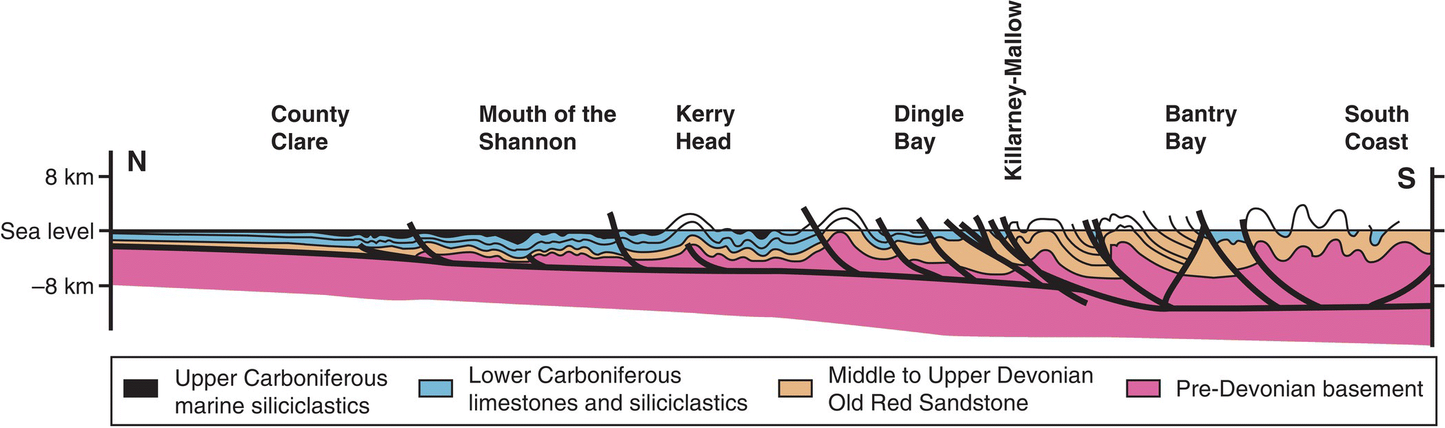
Fig. 2.3.1. Simplified structural profile of southern Ireland (after Bresser & Walter, 1999).

Fig. 2.3.2. Simplified structural map of County Clare (after Coller, 1984).
Reproduced with permission from the Geological Society of London.


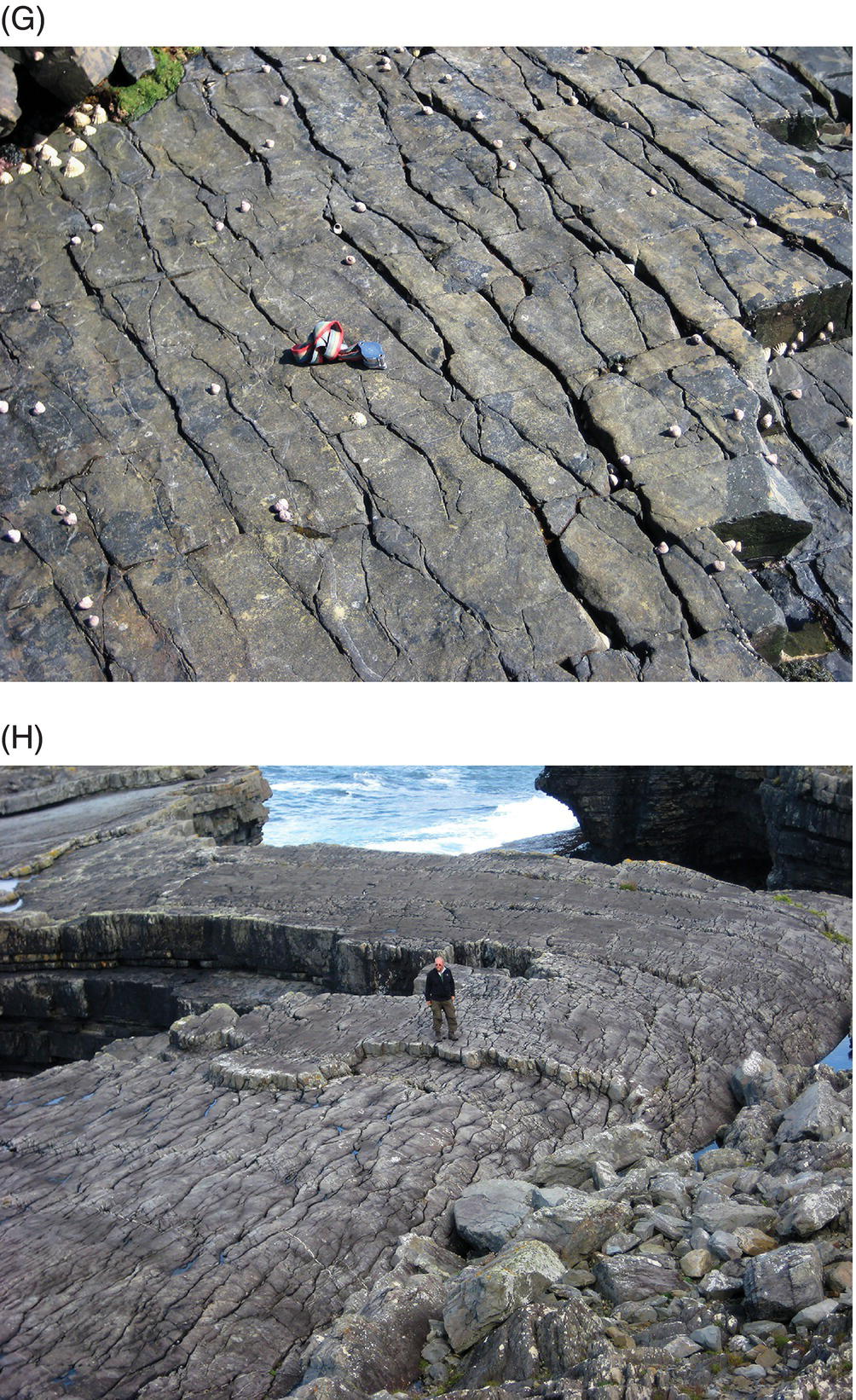
Fig. 2.3.3. A) Typical open fold in Mississippian carbonates of the Burren, Mullaghmore
(Photo taken from UTM 498989 m E 5872143 m N; Map 51, 131898 m E, 194683 m N).
B) Anticline in Ross Sandstone Formation at Bridges of Ross (UTM 440853 m E 5827157 m N; Map 63, 073110 m E, 150486 m N). C) Fanning of cleavage around a fold in Ross Sandstone Formation near Dunmore Head (UTM 439045 m E 5823411 m N; Map 63, 071249 m E, 146763 m N). D) Typical monocline in Ross Sandstone Formation east of Ross (UTM 441899 m E 5827504 m N; Map 63, 074161 m E, 150818 m N). E) Small scale parasitic fold on the larger fold shown in D). These small scale folds are relatively uncommon except in the multilayer packages such as shown here. (UTM 442041 m E 5827468 m N; Map 63, 074303 m E, 150780 m N). F) Spaced pressure solution cleavage in the Ross Sandstone Formation seen in both plan and profile, Kilbaha (UTM 442085 m E 5824880 m N; Map 63, 074311 m E, 148190 m N). G) Pressure solution cleavage seen as an anastamosing pattern on bedding plane surface, Ross Sandstone Formation, Kilbaha (UTM 442085 m E 5824881 m N; Map 63, 074311 m E, 148191 m N). The pressure solution seams of insoluble residue typically weather preferentially to produce a series of anastamosing cracks in plan view on many exposed bedding surfaces throughout the basin. H) Anastamosing pressure solution seams on bedding plane of Ross Sandstone, Bridges of Ross (UTM 441574 m E 5827293 m N; Map 63, 073833 m E, 150612 m N). The cleavage is slightly oblique to the fold hinge.
A detailed, balanced cross-section of west County Clare has been produced by Tanner et al. (2011; Fig. 2.3.4). Tanner et al. (2011) noted that the folds had statistically-horizontal plunges and that the fold geometry was dependent on lithology. The thick sandstone beds of the Ross Sandstone Formation are characterised by box folds, whereas higher stratigraphic units are characterised by parallel folds, with the geometrical differences accommodated by the muddy Gull Island Formation. Tanner et al. (2011) used commercial software (MOVE 2008.1) containing an algorithm that enabled de-compaction of the section and substituted porosity data from comparative North Sea sediments, in an attempt to allow for over-pressuring. Application of their retro-deformation technique suggested that the Kilkee and younger cyclothems varied in thickness above pre-existing folds in the lower part of the section, thus indicating syntectonic deformation. Tanner et al. (2011) suggested an increase in shortening with increasing age of the rocks (from 1.1% to 7.4%) and also proposed that the most marked shortening occurred between 318.25 and 317.75 Ma at c. 30 mm a-1. The numerical ages were based on correlation of the goniatite biostratigraphy with the radiometric time scale of Menning et al. (2000). This overall estimate of shortening is consistent with that of Dolan (1984) and Bresser & Walter (1999) of 11.5%, as this included more strongly-deformed areas further south, but it is less than the 15% estimated by Le Gall (1991) for the Shannon Basin. Estimates for the base of the Tullig Cyclothem (Tanner et al., 2011) suggest 2.64% of shortening was due to folds and 4.8% was due to thrusts. A general lateral change from kink geometries in the south to concentric geometries in the north was interpreted as due largely to lithological control.
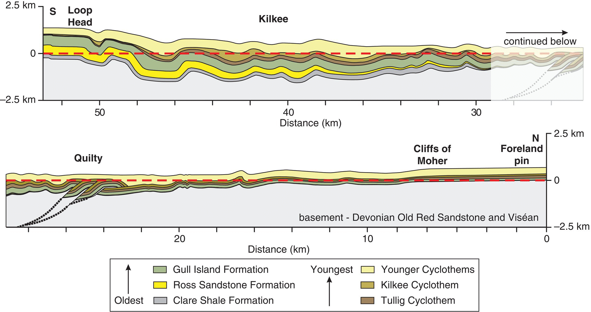
Fig. 2.3.4. Structural profile of the well-exposed west coast sections (from Tanner et al., 2011).
Reproduced with permission from the Geological Society of London.
Cleavage is present throughout much of the Shannon Trough, although it is only weakly developed or even absent on the undeformed ‘flats’ of the box folds. Cleavage also gradually decreases in intensity and occurrence northwards. The cleavage is a spaced, pressure solution cleavage (Fig. 2.3.3F, G and H) that is generally at a high angle to bedding in the competent limestone and sandstone lithologies with marked fanning around the folds (Fig. 2.3.3C). The cleavage is locally a penetrative fabric in mudrocks, particularly in fold hinges in the southern part of the basin. The pressure solution cleavage is partly a temperature-controlled fabric that is typical of rocks that have been moderately hot at temperatures < 350 to 400° C, at which temperatures crystal plastic processes start to dominate (Rutter, 1976, 1978). Such fabrics can develop in areas of relatively low strain, such as County Clare, if palaeotemperatures were sufficiently high. The pressure solution seams are loci of quartz dissolution with consequent formation of a clay-rich residue (Nenna & Aydin, 2011a).
These pressure solution seams were referred to as ‘closing mode structures’ by Nenna & Aydin (2011b), who showed these seams are genetically and temporally related to a series of joints and veins (‘opening mode structures’) that occur almost orthogonal to the strike. In an area of detailed investigation on the Loop Head Peninsula, the pressure solution seams have an average orientation of 075°, whereas the joints and veins have a mean orientation of 170°. These veins form dextral vein arrays trending NNW that are themselves en echelon and define larger-scale ENE trending dextral shears along anticlinal fold hinges, a pattern consistent with overall dextral transpression. The arrays exposed on bedding planes are pinnate fractures (edge effects) at terminations of large individual NNW trending veins. Some of these NNW trending dextral vein arrays have recently been described in detail by Nenna & Aydin (2011b). These NNW trending veins cross-cut earlier bed-parallel veins formed by flexural slip. The veins can be interpreted as synchronous with the late folding history because axial planar cleavage intensifies into the vein arrays and the veins themselves are deformed by the cleavage. Splays of both the joint-vein sets and the pressure solution seams are consistently 35 to 40° clockwise of the main structures and were interpreted as suggesting a clockwise rotation of the principal stresses during deformation (Nenna & Aydin, 2011b). This is entirely consistent with Variscan structures further south (see Graham (2009c) for a summary). The veins contain fibrous quartz crystals that are thin near vein walls and thicken towards the vein centre. The fibres are commonly straight but oblique to the vein walls, suggesting precipitation contemporaneous with strike-slip motion. The geometry of the various structures (folds, cleavage, faults, veins, joints) indicates that they are all related to a single stress system and are probably roughly contemporaneous.
The thermal history of the Shannon Trough has been investigated by examining the maturation of organic matter, conodont alteration indices and the crystallinity of white mica and chlorite. All of these measures are known to be both time and temperature dependent, but it is generally thought that organic maturation can provide useful estimates of peak burial temperatures. The maturation map of Ireland (Clayton et al., 1989) plots calibrated values from vitrinite and conodont data for rocks at the surface (Fig. 2.3.5). It can be seen that much of south and west Ireland shows high maturation values that appear to be independent of stratigraphic position and they also show little correlation to the amount of strain. These levels are much greater than might be anticipated from simple overburden estimates (Fitzgerald et al., 1994). In western County Clare, siltstones and coals of Namurian age (310 Ma) yield vitrinite with maximum reflectance (Rmax) of approximately 6 to 7.5% and conodonts from limestone concretions have conodont alteration indices (CAI) of 5. These data suggest peak burial temperatures of 340 to 370° C. Such temperatures would be consistent with the development of the pressure solution cleavage.
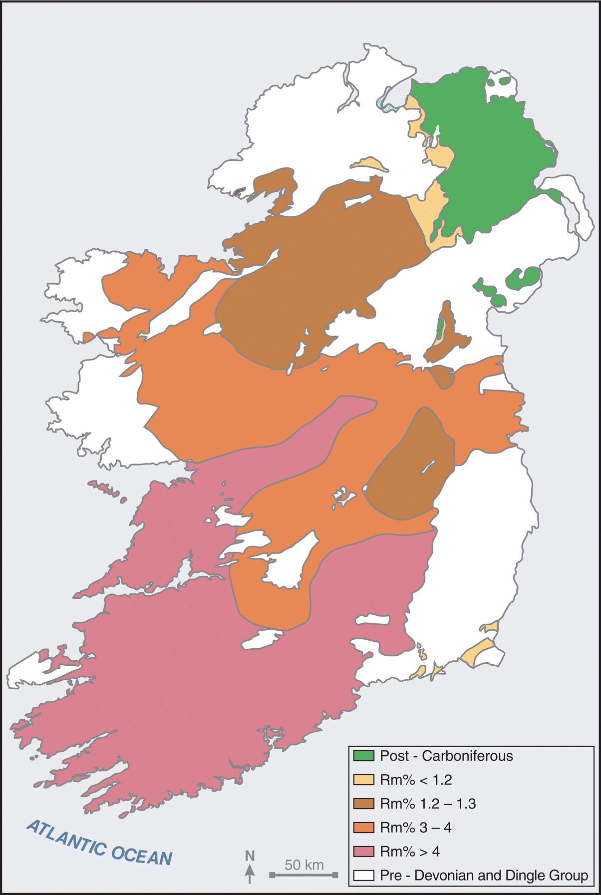
Fig. 2.3.5. Thermal maturation levels in surface exposures of the Devonian and Carboniferous rocks of Ireland (after Clayton et al., 1989).
Clayton & Baily (1999) examined oriented coal blocks from the limbs of folds at Croan Rocks and Killard. They showed that the optic fabric of the coals (‘vitrinite reflectance indicatrix’ sensu Levine & Davis, 1984; 1989) is uniaxial negative, with Rmax developed on planes parallel to bedding and Rmin consistently perpendicular to bedding. This type of fabric is considered to typify pre-tectonic coalification, in contrast to the strongly biaxial fabrics of syntectonic coalification. This suggests that the folds post-date maximum heating and is difficult to reconcile with the interpretation of synsedimentary folding suggested by Tanner et al. (2011).
Where there is evidence of vertical variation of maturation from boreholes, the observed pattern is not that which would be expected from simple overburden-induced heating. Data from the 3 km deep Doonbeg No. 1 Well do not show the expected increase in maturation with depth but rather a more complex profile with an apparent reverse gradient in the upper part of the Dinantian carbonates (Fig. 2.3.6; Fitzgerald et al., 1994; Clayton & Baily, 1999; Goodhue & Clayton, 1999). A similar reverse gradient is seen in the Slievecallan borehole, although here it occurs near the base of the Clare Shale (Goodhue & Clayton, 1999). Simple burial metamorphism seems inadequate to explain these data, and fluid advective heating has been suggested as the most likely mechanism (Fitzgerald et al., 1994; Clayton & Baily, 1999).

Fig. 2.3.6. Distribution of vitrinite reflectance (Rm) in the Doonbeg No. 1 Well (after Clayton & Baily, 1999).
Fitzgerald et al. (1994) present arguments to suggest that fluids in veins would have been in thermal equilibrium with the enclosing rocks. Analysis of fluid inclusions from these quartz veins permits some estimation of burial temperatures, although these estimates do make several assumptions. The maximum entrapment temperatures (240 to 400° C) overlap the calculated vitrinite reflectance-based burial temperature estimates (340 to 370° C). The modal estimate of entrapment temperatures for the fluid inclusions (220 to 250° C) is significantly lower but is consistent with maximum burial temperatures being achieved before folding (Clayton & Baily, 1999), followed by cooling during folding, uplift and vein formation.
Thus, the rocks of the Shannon Trough indicate relatively low levels of tectonic deformation but higher than expected burial temperatures, and there is some evidence that the peak temperatures preceded fold development. The overall stress regime was one of dextral transpression. It is difficult to account for the acquired burial temperatures by tectonic overburden and it thus seems probable that some form of advective heating was involved.