1,000 loan and he asks:
4 |
The Essentials of Surveying |
Surveying may be the most boring aspect of building a house, but it is also one of the most critical tasks you will have to undertake. It is important that you understand the essentials of surveying. If you do, you will save yourself numerous headaches and a considerable amount of time and money.
The first thing you have to deal with in surveying is what we call “the reality of requirement.” Have you ever gone to a bank to apply for a loan? If you have a good income and plenty of credit-worthiness, you no doubt feel there is no reason why you should not be able to obtain a loan. The well-dressed loan officer sits behind his desk, with a booklet in his hand and asks you questions. You’re applying for a 1,000 loan and he asks:
“What’s your name?” You tell him.
He asks, “Middle name?” And you tell him.
“How do you spell it?” “What’s your spouse’s name?” “Middle name?” “Where are you from?” “Where were you two years ago?” “Where were you five years ago?” “Where were you born?”
And you sit there, asking yourself; “What is this guy doing? He’s an idiot.”
But worse, not only is he asking these dumb questions, but you’re giving him the answers. Why?
Because he has the money—and that is the reality of requirement. The identical scenario exists in surveying. The more intellectual you are the more difficulty you are likely to have with the surveying process. But you must comply with the surveying needs of the people building your home or you won’t get far.
Who needs your survey? Almost everyone involved in the building process, including some of the tradesmen, will need your survey. The excavator needs to know where to clear the house site. The builder needs to know where to place the house. The county and architectural review board need to know that the house conforms to their setbacks. The title company that insures your property wants a survey, and so does the lender. Solution: Get a survey, get it early, and make it complete.
The second thing to remember when you consider surveying is that you must think three-dimensionally. If you think only two-dimensionally you’ll run into considerable trouble and worry. A bird’s-eye view means looking down; a human view means looking straight ahead. If you combine the two you end up with three dimensions.
This story involves two ancient Romans whom we will call Tully and Cicero, which will illustrate three-dimensional thinking. They were good friends and both had good incomes. They grew tired of the traffic in Rome with all the chariots and dust, and one day they decided to go outside of Rome and buy a large tract of land and build a home.
Tully said “Well, I can’t afford to buy a five-acre tract by myself.”
Cicero said, “I can’t either. We’ll buy ten acres together and subdivide it.”
So they went out, bought ten acres, and built very simple homes.
Their land was as flat as a pancake and very barren. At this point Tully and Cicero were very good friends. They built separate houses on their own subdivided property, shared a chariot together, went out on the town together, and worked on their chariots on weekends. Then one day Tully said: “It’s awful barren out here.” So he planted an olive tree which took a number of years to grow large and produce fruit.
Tully planted this olive tree on his side of the property line. But over the years the olive tree grew larger and its branches extended over Cicero’s property as well. However, as the tree grew and prospered the relationship between the two Romans deteriorated. Ultimately they were feuding continually and Cicero decided he would do anything he could to complicate Tully’s life. One day he said, “Your olive tree’s branches are on my property!” And he sued Tully for civil trespass. They went to trial. Who won?
Cicero won. The ruling was that the overhanging branch constituted trespass, and that ruling is applicable today in most western societies.
This is why we want you to think three-dimensionally. Consider not only where you’re going to position your house on your property, but how high up the roof is going to be, how deep in the ground the basement is going to be, and whether any portion of the house is going to hang over a setback or property line.
In order to begin the survey process, it’s essential that you know who the players are. There are five of them: the owner, the builder, the surveyor, the county (or city), and the lender. They all want to know the dimensions of your land and where you’re going to build your home.
The first people to be involved in the survey will be you and your spouse, if you have one. You should go out to your property yourselves, walk around, and decide where you’re going to position your home. Using the two-dimensional bird’s-eye approach, look down on the land and see where you want your house to be. Using the human-eye view, decide how far down in the ground you want your basement. Then imagine how high up the roof line will be. Imagine views and approaches. What will it overhang? Then select your site and place your markers for the location of your house.
The next person to be involved will be the builder. Bring the builder out and show him where you’ve positioned your home. The builder may walk over to the edge of the cliff where you’ve positioned your house and tell you, “I can save you 5,000 if you move your house back about ten feet.”
Your spouse says, “Why? I like the view.”
The builder says: “We don’t have bulldozers with wings and we can’t fly around out there.”
“All right, how about here?”
“No, not back there, because this big rock is going to cost you 5,000 to move. Let’s move it over here away from the rock and the edge.” So you, your spouse, and your builder position your house. “Why didn’t I bring the builder out to begin with?” you ask. If you had come out first with your builder he would have immediately said, “Let’s build it right here,” at the easiest spot on your property on which to build a house. You should pick your spot first and then have your builder tell you what, if anything, is wrong with your position. If he convinces you that your position will cause problems or undue expense then you should work together to reach a compromise position.
The next person to be involved is the surveyor. You need a survey to make sure the house is positioned within the property line, within the county setbacks and covenant restrictions, and complies with all easements (such as a power line) and is not on your septic field or the like.
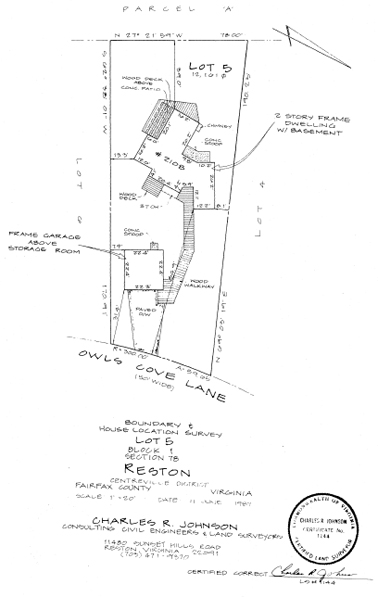
The surveyor, finding that your house is now properly positioned, will prepare a document called a Proposed House Location Survey.
The Proposed House Location Survey is sometimes referred to as the site plan or grading plan. We prefer proposed house location survey because the term “proposed” denotes that something is planned, something is to be done. The PHLS is a critical component for the following parties:
(1) The Builder. It tells the Builder where to position your home on your property. If properly done it tells him not only left and right placement but depth and height.
(2) The County. In most jurisdictions the County will require the PHLS to accompany your plans and specifications as part of the building permit application. The permit department will review both documents for accuracy and code and zoning compliance before a permit will be issued.
(3) The Title Company. Before a lender will make you a loan he will require certification of clear title and survey compliances. Accordingly, the title company will require the PHLS (just as the county does) to review it for title compliance. The PHLS must show that your project complies with zoning, covenants, and easements before the title company will insure your project. Without the title insurance you cannot obtain funding.
The PHLS as outlined above is the first survey document you’ll need, and you’ll need it before your project can begin. Once all of the approvals have been obtained, the surveyor goes to your property and physically stakes the home site following the placement on the PHLS.
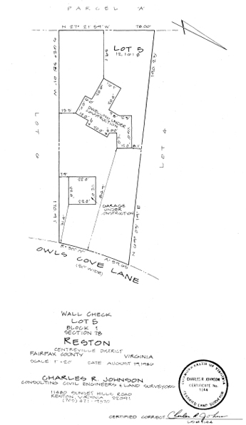
The next step includes the owner, the builder (who might also be you), and the mason. The mason comes out, lays your foundation, pours the concrete, and puts in your foundation walls, carefully following the stakes which show where the foundation is to be built. When the foundation is completed the mason wants his money. So you go to your lender for your next draw. The lender will ask for your wall check survey.
The wall check survey is simply a confirmation by your surveyor that your foundation was actually built where the house location survey said it would be built. We have seen grown men and women go berserk when told by the lender that they needed another survey to confirm the first survey. Before the lender will advance more money, however, he must be absolutely certain that the house is being built where it was supposed to have been built, and the only way he can have proof of that is with another survey of the actual existing foundation. The reason he is insistent on this survey is that if there has been some mistake and the house is built in violation of your setback requirements, there is no recourse. The county or your property owner’s association could insist that the entire structure be torn down even if you have completely finished your house. Obviously the lender cannot take a chance on that—and you shouldn’t either.
Now is the time to check your project for compliance before you proceed with expensive improvement. The cost of the wall check is minimal.
When your home is completed most lenders (there are only rare exceptions to this requirement) will require a final house location survey before they will advance the final draw on your loan or grant you your permanent loan. The requirement generally surprises and frustrates the homeowner. “Why do I need this now?” the often irate owner asks. “You already checked the foundation. Do you think I moved the house?”
The lender’s answer is, “No, we don’t think you moved your house, but we want to be certain that the eaves on the roof, the chimneys, and the decks are also in compliance.” Remember the story of Tully and Cicero? We’ve seen houses where foundations comply with setback requirements but whose roof lines do not. The penalty for failure to comply is removal, not compromise.
So there are three major surveying requirements: the proposed house location survey, the wall check survey, and the final house location survey.
Know these surveys well, as you’ll generally need all three.
Let’s take a broader look at the surveying sequence. In all probability the first survey at which you will look is your boundary survey—a two-dimensional portrayal of your property as the bird sees it. It tells you a great deal, but not everything, about your property.
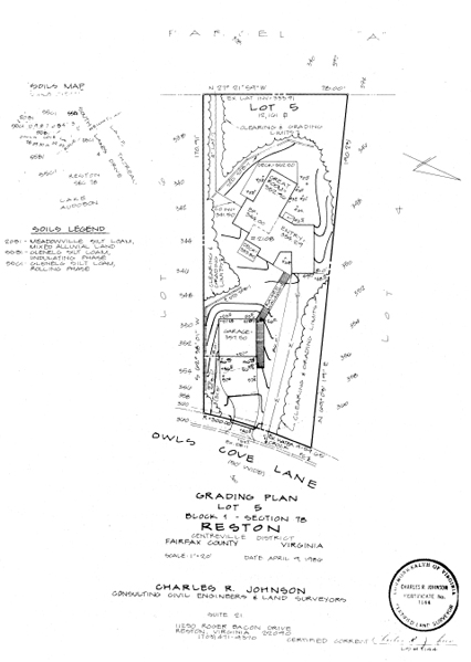
Of equal importance is the topographical survey—a three-dimensional portrayal of your property. It depicts not only boundaries but the high and low portions of your property. Knowing the high and low points are important for the proper placement of your home for appearance, access, views, drainage, and building cost. A topo map is an important element in the building of your home.
With a topo map you, your builder, and your architect can select the best location for your home. With instruction from you, your architect, and the builder, the surveyor can now lay out your home on the property not only within the boundary and setback requirements (a two-dimensional condition) but also positioned vertically to fit the contours of your property. This placement will determine the precise three-dimensional position of your home.
The placement of your home within your property or setback lines is relatively easy. The surveyor simply puts stakes in the ground. But how does a surveyor tell the builder the vertical positioning of your home? He does it with elevation readings or marks. All elevations are keyed to sea level. If the first floor of your house is to be 208 feet above sea level, the surveyor will state that on his survey (site plan). He will then provide the builder with a bench mark, which is a measurement above sea level. For example, the surveyor will nail a stake on a tree at a point located at 210 feet above sea level and mark it “210′.” The builder then knows that the mark in the tree, the bench mark, is 210 feet above sea level. He can now adjust the foundation of the house so that the first floor will be at 208’.
The surveyor should also supply cut and fill data. Based on the surveyor’s knowledge of your land from the topo map, he can tell the builder where to cut the land down and where to fill in the land so your home will be exactly where you want it.
The surveyor provides information (stake, bench marks, cut and fill data) to place the home not only within the property lines but within the property vertical space.
If you have a wooded lot there is a two-step process for the surveyor to follow: The first step is for the surveyor to stake the area that is to be cleared for the driveway, septic tank, and homesite. Make sure that he identifies which trees are to be left and which are to come down. After the site is cleared, he returns to stake the actual homesite, including bench marks. Do not stake the actual homesite prior to clearing because the clearing process may destroy the stakes, requiring the field survey to be done again.
Make sure your surveyor stakes your house location with offset stakes. Offset stakes are set some predetermined distance away from the actual corner (generally 10 feet). This gives the builder room to work around the corner without knocking over the stakes.
In discussing your survey with the surveyor, the architect, or the builder, certain technical terms (some of which we have already discussed) will come up and you should be familiar with them:
Bench mark—This is a reference point the surveyor will put on or near your property to indicate height. It will usually be a stake nailed on a tree with a figure written on it. The builder uses this bench mark to determine how high the house will be or how high the first floor will be. In some areas you have to build to a certain height because of the floodplain, but usually you will be concerned about the height of your house because of a view that your want to preserve.
Elevation—This is the term used in discussing the height of your house, the roof, or one of the floors.
Topo lines—These are the lines on your survey that show the height or elevation of the land.
Accretion—Let’s say you have a piece of property on which the boundary line is determined by a stream or a river. Gradually the river or stream changes course, thereby changing the boundary lines of the property. The law recognizes that property lines determined by streams or rivers can be changed, and sometimes there are lawsuits and a court has to decide what is fair. Accretion is the term used for land legally gained by a stream changing course gradually over time.
Reliction—This is the term for land legally lost by a stream gradually changing course.
Avulsion—When a sudden jump of a stream or a river causes the sudden removal of soil from the land of one owner to another—usually caused by a storm or flood—this is called avulsion. There is no change of property ownership or boundary lines when avulsion has occurred.