9 Castlewood State Park: River Scene Trail
This loop trail offers visitors a steep climb to scenic limestone bluffs and a flat finish through the floodplain along the Meramec River in Castlewood State Park.
Distance: 3.4-mile loop
Approximate hiking time: 1.5 hours
Difficulty: Moderate due to modest climb
Best season: Year-round
Park hours: Open 7 a.m. to half hour after sunset
Other trail users: Mountain bikers allowed on a portion of the trail
Canine compatibility: Leashed dogs permitted
Fees and permits: None
Maps: USGS Manchester; park map available at visitor center
Trail contacts: Castlewood State Park, 1401 Kiefer Creek Rd., Ballwin, MO 63021; (800) 334-6946; www.mostateparks.com/castlewood.htm
Special considerations: Ticks, mosquitoes, and poison ivy are common in warmer months.
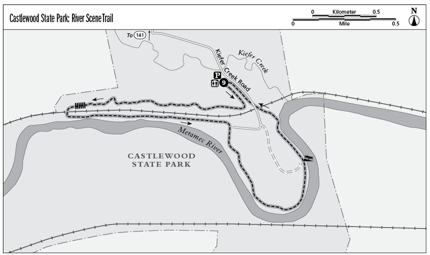
Finding the trailhead: From St. Louis take I-44 West for 16.8 miles to exit 272 (MO 141). Merge onto North Highway Drive and then take a slight right onto MO 141 for 1.8 miles. Take the Big Bend Road ramp, staying left on West Big Bend Road. Drive 2.4 miles to Ries Road. Turn left onto Ries Road and travel 1 mile, then turn left onto Kiefer Creek Road into the park. Continue 0.4 mile to the trailhead parking area, picnic shelter, restrooms, and playground on the left (northeast) side of the road. GPS: N38 32.993 / W90 32.371
The Hike
Known as “St. Louis’s Peaceful Escape,” Castlewood State Park is a popular destination for many outdoor enthusiasts in the area. Hikers, equestrians, and bikers share many of the trails in the park. Anglers and paddlers also use the park as an access point to the Meramec River.
The River Scene Trail showcases some of the finest sights in the park. Limestone bluffs offer good views of the Meramec River. The trail gives visitors a taste of upland forest, consisting of mostly white oak and shagbark hickory, as well as a glimpse of bottomland forest, which includes silver maples, box elders, and sycamore trees.
From the parking area, cross Kiefer Creek Road and locate the signed trailhead for the River Scene Trail to the southwest. Follow the trail to the south as it parallels Kiefer Creek Road before ascending a moderately steep and rocky ridge. As you near the top of the ridge, the Meramec River comes into view to the south. Come to the first of several scenic overlooks at 0.3 mile. At 0.4 mile the trail forks; hikers stay left and mountain bikers go right. Stay left at another fork at 0.5 mile. Avoid the bike trail at 0.7 mile, continuing west on the hiking trail. Shortly after, descend a series of wooden steps and cross a boardwalk at 1.1 miles.
Cross under the railroad tracks at 1.2 miles and follow the trail as it curves to the east. The trail surface at this point alternates between moist sand and dirt, providing excellent opportunities to look for wildlife tracks, such as wild turkey, raccoon, and white-tailed deer. After 2.0 miles come to an intersection with a connector trail; stay right and follow the red arrows to continue on the River Scene Trail. Come to a river access point at 2.8 miles and continue north, passing an information kiosk. At 3.2 miles the trail reaches Kiefer Creek Road and crosses under the railroad tracks. Cross Kiefer Creek Road on the north side of the railroad tracks and follow the trail back to the trailhead parking area.
Miles and Directions
0.0From the signed trailhead turn left and follow the River Scene Trail south.
0.3Come to the first of several scenic overlooks.
0.4Hikers stay left at the fork.
0.5Reach another fork; hikers stay left.
0.7Avoid the bike trail to the right (north); continue west on hiking trail.
1.1Come to boardwalk.
1.2Cross under the railroad tracks and follow the trail as it curves to the east.
2.0Come to an intersection with a connector trail. Stay right (south), following the red arrows.
2.8Reach the river access point; continue north on a paved trail.
3.0Stay right (north) at the fork on the dirt trail.
3.2Come to Kiefer Creek Road; cross under the railroad tracks, then cross the road. The trail continues to the northwest.
3.4Return to the trailhead.