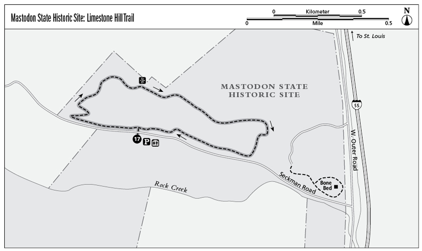
17 Mastodon State Historic Site: Limestone Hill Trail
The longest trail in Mastodon State Historic Site, the Limestone Hill Trail offers a rugged but scenic hike that traverses the base of an interesting limestone bluff.
Distance: 2.0-mile loop
Approximate hiking time: 1.5 hours
Difficulty: Moderate due to modest climb
Best season: Fall through spring
Park hours: Open 8 a.m. to half hour past sunset
Other trail users: None
Canine compatibility: Leashed dogs permitted
Fees and permits: None
Maps: USGS Lake Killarney; trail map available at visitor center
Trail contacts: Mastodon State Historic Site, 1050 Museum Dr., Imperial, MO 63052; (636) 464-2976; www.mostateparks.com/mastodon.htm
Special considerations: Ticks and poison ivy are common during warmer weather. Use caution when crossing Seckman Road.
Finding the trailhead: From St. Louis take I-55 South for 20.7 miles to exit 186 (Imperial Main Street). Turn right onto Imperial Main Street and then make an immediate right onto West Outer Road. Drive 0.6 mile on West Outer Road to a stop sign; turn left onto Seckman Road. Follow Seckman Road for 0.8 mile into the park and to the parking area on the left. GPS: N38 22.821 / W90 23.690
The Hike
The bones of ancient mastodons were found here in the early 1800s. The Kimmswick Bone Bed, a Pleistocene epoch deposit, quickly gained fame among scientists from around the world. In 1979 a stone spear point 10,000 to 14,000 years old was excavated, confirming the existence of humans and mastodons in the same time period.
The 431-acre Mastodon State Historic Site offers three hiking trails. Hikes range from short and simple strolls along the bone beds and the Callison Memorial Bird Sanctuary to the longer Limestone Hill Trail. Hikers can expect the usual mixed-hardwood forests of oak, hickory, and maple trees. For a small entry fee, you can visit the museum to view mastodon fossils, bones, and other artifacts.
The Limestone Hill Trail begins at the only picnic site in the small park. This loop is the longest and most challenging hike in the park. The Limestone Hill and Spring Branch Trails share the same trailhead and can be easily combined to extend your hike by 0.75 mile.
From the north end of the parking area, locate the information kiosk and trailhead marker. Follow the obvious gravel trail and the trail markers for Limestone Hill Trail west and then north to cross Seckman Road (0.1 mile). On the other side of Seckman Road, turn left (west) and follow the trail as in parallel Seckman Road.
At 0.3 mile the trail curves to the right (north) and ascends the hill to a bench and scenic overlook at 0.7 mile. Stay right to avoid a spur trail and continue southeast on the Limestone Hill Trail.
At 1.2 miles come to another fork in the trail. Stay right and follow the trail marker, which points south, down a gradual hill. Return to Seckman Road at 1.9 miles. Cross the road and continue south to the trailhead parking area.
Miles and Directions
0.0From the trailhead begin hiking west then north toward Seckman Road.
0.1Cross Seckman Road and turn left (west).
0.3Follow the trail as it curves to the right (north) and ascends a hill.
0.7Come to a bench and scenic overlook. Keep right to avoid a spur trail.
1.2Stay right at the fork to continue on the Limestone Hill Trail.
1.9Cross Seckman Road and continue south.
2.0Return to trailhead.