RATING |
|
 |
DISTANCE |
|
2.0 miles round-trip |
HIKING TIME |
|
1 hour |
ELEVATION GAIN |
|
200 feet |
HIGH POINT |
|
2,600 feet |
EFFORT |
|
Easy Walk |
BEST SEASON |
|
Year-round |
PERMITS/CONTACT |
|
Castle Crags State Park day-use fee required |
|
|
($8 per vehicle), (530) 235-2684, www.parks.ca.gov |
MAPS |
|
USGS Dunsmuir |
NOTES |
|
Dogs and bikes prohibited |
THE HIKE
Admire the jagged profile of the multiple spires of Castle Crags and walk alongside a babbling brook on this easy jaunt in Castle Crags State Park.
GETTING THERE
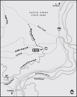
From Redding, drive 50 miles north on Interstate 5 and take the Castle Crags State Park exit, 4 miles south of the town of Dunsmuir. Turn west and follow the signs to the park entrance. After paying at the kiosk, turn right and follow the road to its end at the Vista Point parking area. The trail for the vista point is at the parking lot; the Root Creek Trail begins about 40 yards downhill from the parking lot.
THE TRAIL
Have you ever driven north on I-5, gaping at the looming volcanic cone of Mount Shasta, and then suddenly looked over your left shoulder and seen those big, gray, craggy rocks looming over you—the unmistakable jagged outline of Castle Crags’ ancient granite spires?
From afar, the Crags look awesome, but getting close to them is even better. The only problem is that the jagged spires of Castle Crags head straight up into the stratosphere. The trails to reach the crags are remarkably steep: The Crags Trail to Castle Dome’s base gains 2,300 feet in less than 3.0 miles, a prodigious climb. But here’s a more manageable way to get a good look at Castle Crags.
From the Vista Point parking lot, start your trip by allowing plenty of time to admire the view of Castle Crags straight ahead, Mount Shasta to your right, and Grey Rocks to your left. Conical Mount Shasta at 14,162 feet is quite plainly a volcano, but Castle Crags is a completely different type of geological formation, made of granodiorite that was formed below the earth’s surface millions of years ago and then slowly forced upward. The formation called Grey Rocks looks vastly different from either Mount Shasta or Castle Crags. It is yet another geologic type, composed of greenstone and slate metamorphic rock that was thrust upward and sideways from the earth and weathered by the centuries.
After taking in all this geologic diversity, head down the access road from the Vista Point parking lot for 40 yards to the trailhead for the Root Creek Trail. This pleasant trail is mostly level and travels through a conifer and hardwood forest to join and then follow the path of Root Creek. Conifer needles cushion your feet and five-finger ferns point the way. Root Creek bubbles over rounded rocks and is framed by an abundance of elephant’s ear—giant-leafed water-loving plants, up to 2 feet high—on its banks.

In spring, Root Creek’s large-leaved elephant’s ear plants begin their growth as delicate flowers.
At trail’s end you get a surprising look straight up at Castle Dome—the big, smooth, rounded rock formation that leads the parade of crags. Hang out here for as long as you like (a wooden bench has been installed for that purpose) and then backtrack to the parking area.
GOING FARTHER
The Root Creek Trail connects with both the Crags Trail and the Pacific Crest Trail; you can add an out-and-back hike on either of these trails. Or, if you are in the mood for an adventure, a faint path forks off the Root Creek Trail to Root Creek Falls, which is located outside the state park boundary in national forest land. The distance one-way from the parking lot to the falls is only 2.8 miles, but since this is not a maintained trail, it’s very slow going. Plans are in the works to build a “real” trail, but right now this is a path made only by occasional use, so the trip is best saved for tenacious hikers.