RATING |
|
 |
DISTANCE |
|
3.0 miles round-trip |
HIKING TIME |
|
1.5 hours |
ELEVATION GAIN |
|
300 feet |
HIGH POINT |
|
8,000 feet |
EFFORT |
|
Easy Walk |
BEST SEASON |
|
July to October |
PERMITS/CONTACT |
|
Lassen Volcanic National Park entrance fee required ($10 per vehicle, valid for seven days),
(530) 595-4444, www.nps.gov/lavo |
MAPS |
|
Lassen Volcanic National Park
(download at www.nps.gov/lavo) |
NOTES |
|
Dogs and bikes prohibited |
THE HIKE
Boasting the largest concentration of hydrothermal features in Lassen Volcanic National Park, Bumpass Hell was named after an 1860s settler who lost his leg after falling into a boiling pool.
GETTING THERE
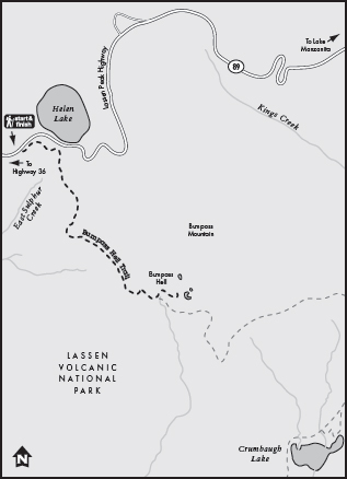
From Red Bluff on Interstate 5, turn east on Highway 36 and drive 45 miles. Turn north on Highway 89 and drive 4.5 miles to the park’s Southwest entrance station. Continue north on Lassen Park Road for 5.8 miles to the Bumpass Hell trailhead on the right.
THE TRAIL
If you travel Lassen Volcanic National Park with children, you will quickly learn that Bumpass Hell is their favorite destination because it has the distinction of not one but two foul words in its name. When you explain that “Bumpass” was the name of the man who discovered this strange geologic area, this distinction may be lessened somewhat, but then again, maybe not.
The “Hell” in Bumpass Hell is easy to recognize. Bumpass Hell is an active hydrothermal area, part of the Lassen geothermal system, which encompasses Bumpass Hell, Sulphur Works, Boiling Springs Lake, Little Hot Springs Valley, Morgan Springs, and Terminal Geyser. Bumpass Hell is geology in action—16 acres of boiling springs, hissing steam vents, noisy fumaroles, and bubbling mud pots.
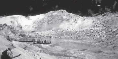
The steaming, hissing, volcanic landscape of Bumpass Hell can be safely explored by staying on the boardwalks and marked paths.
All this geologic commotion is the result of crack-like fissures in the earth that penetrate deeply enough to tap into volcanic heat (or with a little imagination, into the searing hot landscape of Hades). Surface water from rain and snowmelt seeps into these fissures and travels downward until it touches volcanically heated rock. This creates steam, which rises back up to the surface. As a result, pools of water in the Bumpass Hell area can reach temperatures of 200 degrees Fahrenheit. Kendall Vonhook Bumpass, who discovered Bumpass Hell in the 1860s, lost one of his legs when he stepped into one of these boiling, acidic pools.
Fortunately today we have a trail to follow in Bumpass Hell, and a wealth of signs that remind us to stay on the boardwalk and off the unstable soil. The hike is an easy stroll with a very gradual elevation change. In addition to its fascinating geology, the Bumpass Hell Trail features wide views of surrounding peaks, especially near its start. In 0.5 mile from the trailhead, a spur trail on the right leads to an overlook of Mount Conard, Diamond Peak, Brokeoff Mountain, Mount Diller, and Pilot Pinnacle. These mountains were parts of the ancient volcano Mount Tehama, which stood on this spot in eons past. Long since collapsed and eroded, Mount Tehama once soared to an elevation of 11,500 feet. Lassen Peak may have been formed from lava that flowed from Mount Tehama’s side vents.
As you round a curve and reach the highest point in the trail, you find an interpretive sign explaining the wonders of Bumpass Hell, which is now directly below you. You also hear the strange ruckus caused by all the hydrothermal activity—sounds variously described as steam engines, trucks speeding by, or turbine motors. The smell of sulphur is ubiquitous. A short descent takes you into the hydrothermal area and boardwalks lead you over and around the various hot pools, steam vents, and mud-pots. Most of the hot pools are a striking gray-green to turquoise blue in color. Even the stream that flows through Bumpass Hell is odd looking–its water is milky gray instead of clear.
GOING FARTHER
From Bumpass Hell, you can continue another 1.5 miles to Cold Boiling Lake, then turn around and retrace your steps for a 6-mile round-trip. The “boiling” of this small pond occurs as gases continually bubble up through the surface of the water.