RATING |
|
 |
DISTANCE |
|
2.0 miles round-trip |
HIKING TIME |
|
1 hour |
ELEVATION GAIN |
|
Negligible |
HIGH POINT |
|
100 feet |
EFFORT |
|
Easy Walk |
BEST SEASON |
|
Year-round |
PERMITS/CONTACT |
|
Salt Point State Park fee required
($8 per vehicle), (707) 847-3221, www.parks.ca.gov |
MAPS |
|
Salt Point State Park/Kruse Rhododendron State Reserve (download at www.parks.ca.gov) |
NOTES |
|
Dogs and bikes prohibited |
THE HIKE
Wander along the Salt Point State Park’s wooded blufftops, enjoying peekaboo views of the crashing shoreline.
GETTING THERE
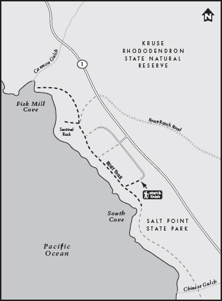
From Jenner, drive north on Highway 1 for approximately 24 miles. Bypass the main Salt Point State Park entrance at Gerstle Cove and turn left at the Fisk Mill Cove parking area, located 2.6 miles north of Gerstle Cove. Park in the parking lot on the left, then find the trailhead on the ocean side of the lot, near the picnic tables and fire grills.
THE TRAIL
Salt Point State Park is blessed with a long stretch of pristine Sonoma coastline, rich tidepools and kelp beds teeming with sea life, and plentiful hiking trails. One of the easiest and most rewarding is the Bluff Trail that begins at Fisk Mill Cove, a few miles north of the main park entrance and campground.
The trail is good from the get-go. As you start down the dirt path, a trail marker points you to the left to South Cove (0.1 mile away), or to the right to Sentinel Rock and Fisk Mill Cove. If you’re visiting in winter or early spring, this signpost is a good place to get a view of a seasonal waterfall that plunges from the bluffs down to the sea. Head left to South Cove, ending up right on top of this small waterfall. Then continue a short distance to the bluffs beyond the cove, gaining more coastal views before the path dissipates in the coastal scrub. When you’ve seen enough, simply turn around and hike back, keeping the ocean on your left. When you reach the trail sign again, continue past it toward Sentinel Rock and Fisk Mill Cove.
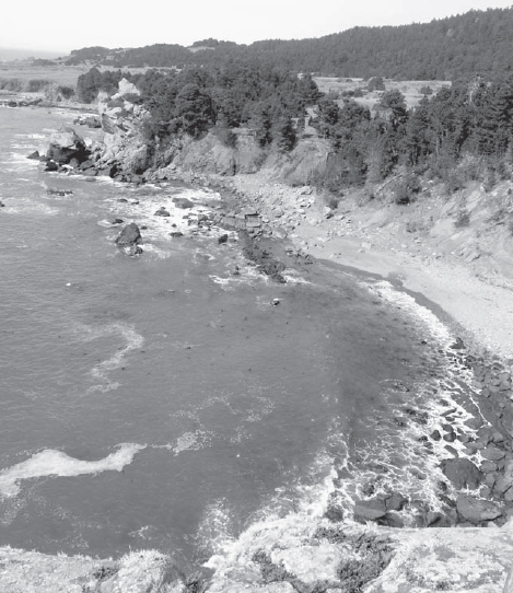
This is not a hike in which you’ll mind retracing your steps. While wandering on the Bluff Trail, you’re never more than 50 feet from the ocean’s crashing shoreline, and often you are tantalizingly closer. Your level path meanders through a forest of ferns, rhododendrons, cypress, and bishop pines. Even while enveloped in the shade of this peaceful woodland, you have peekaboo views of rocky pocket beaches with crashing waves, playful seals swimming in the surf, and abalone divers plying their trade.
The trail crosses three wooden footbridges, spanning streams that carry runoff from the hills down to the ocean. A highlight is a large sandstone formation with tiny hollowed caves. Perhaps most enticing is a lovely trailside meadow, protected from the wind on three sides. During mid- to late April, this meadow is completely covered with purple Douglas irises.
From the Bluff Trail’s high perch, Salt Point State Park’s dramatic coastline is revealed below.
Branching off the Bluff Trail are short spurs leading to vistas of the ocean and coves below. The spurs either dead-end or rejoin the main trail, so it’s impossible to stray too far. The trail’s only major ascent occurs on the stairstepped path to the viewing platform atop Sentinel Rock, a dramatic coastal overlook. A bench on top of the rock invites you to stay a while.
After descending from Sentinel Rock, finish out your trip by following the short path that leads down to rocky Fisk Mill Cove, a picturesque beach and popular spot for abalone diving. Then make the 1.0-mile return walk to your car. Picnic tables and fire grills are situated right at the trailhead, so you might cap off your hike with a spot of lunch.
GOING FARTHER
Proceed to the main park entrance and turn into the inland side of the park, which is signed for Woodside Campground. From the parking area just beyond the kiosk you can take a steep 1-mile hike to see the park’s pygmy forest of stunted cypress and pine trees.