RATING |
|
 |
DISTANCE |
|
2.0 miles round-trip |
HIKING TIME |
|
1 hour |
ELEVATION GAIN |
|
50 feet |
HIGH POINT |
|
100 feet |
EFFORT |
|
Easy Walk |
BEST SEASON |
|
Year-round |
PERMITS/CONTACT |
|
Fort Ross State Historic Park fee required
($8 per vehicle), (707) 847-3286 or (707) 847-3437, www.parks.ca.gov |
MAPS |
|
Fort Ross State Historic Park
(download at www.parks.ca.gov) |
NOTES |
|
Dogs and bikes prohibited |
THE HIKE
Visit a well-preserved relic of the Sonoma coast’s past, then hike an adjacent trail along the coastal bluffs to Fort Ross Cove and the beach beyond.
GETTING THERE
From Jenner, drive north on Highway 1 for approximately 15 miles to the entrance to Fort Ross State Historic Park on the left.
THE TRAIL
On this hike at Fort Ross State Historic Park, you’ll have the chance to learn a little history, explore an old Russian colonial fort, and stroll along the scenic Sonoma coastline.
The Fort Ross Cove Trail is a wander-as-you-please meander through Fort Ross’s stockade walls and along the top of steep bluffs that drop 100 feet into the sea. You can choose your own route, stopping to enjoy the history or the scenery as you wish.
The old Russian fort, with its huge barracks and two-story blockhouses complete with cannons, is an intriguing sight. Built in 1812 in only a few weeks by Russian colonists who were eager for eastern expansion, the fort was occupied until 1841. The smell of the old wooden buildings evokes images of those earlier times, when colonists tried to develop an economy at first based on sea otter pelts and later on agriculture. Neither led to substantial profits.
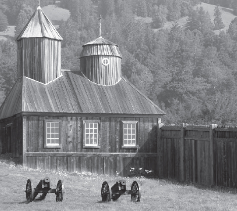
The well-preserved buildings of an early 1800s Russian fort are found along a scenic stretch of the Sonoma Coast.
When you’ve seen enough of the fort’s buildings, follow the gravel road that leads out the main gate toward the ocean. The road circles down into Fort Ross Cove, which was the first shipyard in California, established by the Russians for their pelt-trading business. A few picnic tables are located there.
Explore the tiny cove, which is covered with odd-shaped driftwood and wave-smoothed rocks. A small, shallow stream must be crossed in springtime—a little strategic foot placement on rocks should work, although some hikers prefer the leap-and-pray method of stream crossing. On the cove’s far side, a trail leads up the bluffs; follow it. In spring, you’ll see the usual cabal of coastal wildflowers—lupine, paintbrush, and Douglas irises. Year-round, raptors and seabirds soar overhead.
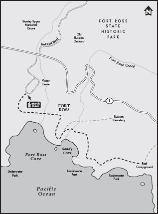
The trail soon descends to a gravel road where you’ll find restrooms and a 20-site campground. A path leads off to the right, down to the beach. Two tiny streams join together here on their way to the ocean, with horsetail ferns growing along their banks. Pick your way among the rocks down to the beach.
GOING FARTHER
Just 1.5 miles north on Highway 1 is another park worth exploring. Drive to Stillwater Cove Regional Park and park in the day-use area. The Stockoff Creek Loop Trail starts here and makes a 1.25-mile loop through a secluded redwood forest; take the spur trail to visit the historic one-room schoolhouse.