RATING |
|
 |
DISTANCE |
|
3.4 miles round-trip |
HIKING TIME |
|
1.5 hours |
ELEVATION GAIN |
|
450 feet |
HIGH POINT |
|
600 feet |
EFFORT |
|
Moderate Workout |
BEST SEASON |
|
November to April, but good year-round |
PERMITS/CONTACT |
|
Muir Woods National Monument fee required |
|
|
($5 per adult), (415) 388-2595, www.nps.gov/muwo |
MAPS |
|
Download at www.nps.gov/muwo |
NOTES |
|
Dogs and bikes prohibited |
THE HIKE
On this trail, Muir Woods shows off its famous coastal redwoods and coursing stream.
GETTING THERE
From U.S. 101 just north of the Golden Gate Bridge, take the Mill Valley/ Stinson Beach/Highway 1 exit and continue straight for 1 mile to a stoplight at Shoreline Highway (Highway 1). Turn left on Shoreline Highway and drive 2.5 miles, then turn right on Panoramic Highway. Drive 0.9 mile and turn left on Muir Woods Road. Drive 1.5 miles to the Muir Woods parking area.
THE TRAIL
The redwoods at Muir Woods National Monument are true beauties. The foliage growing in the big trees’ understory—bays, tan oak, thimbleberry, sword ferns, and sorrel—is lush and green year-round. Redwood Creek, which cuts through the center of the park, is a pristine, coursing stream. So it’s no wonder this tiny national monument, not much larger than a few city blocks, gets visited by more than one million people each year.
How do you hike in the park and see its magnificent trees without getting run over by the crowds? Summer is the busiest time, of course, so it’s best to avoid May to September altogether. Winter and early spring are the least crowded and also the loveliest seasons, when Redwood Creek runs full and high. Any time of year, an early morning start is a smart idea; the crowds don’t usually arrive until about 10 a.m.
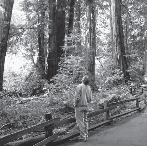
The lush greenery of Muir Woods’ redwood forests inspire quiet moments of contemplation.
Start your trip from the entrance gate to Muir Woods near the small visitor center. The park’s main trail is a wide, boardwalk-lined path that is mostly level and runs along the bottom of the canyon, passing the most impressive redwoods. You’ll walk the entire length of this trail on your return. For now, bear right and in about 100 yards you’ll reach a fork with Ocean View Trail. Follow it up the hillside to the right.
The path is completely forested, but the redwood trees are younger and smaller than in the canyon below and interspersed with many Douglas firs. Ocean View Trail climbs moderately and curves around the canyon until it reaches a junction with Lost Trail at 1.5 miles. (No, despite its name, there is no “ocean view” from this trail.) Bear right on Lost Trail, now heading downhill. Similar to Ocean View Trail, Lost Trail weaves through a young redwood, Douglas fir, and bay forest. Soon it descends more steeply on railroad-tie stair steps, and in 0.7 mile it connects with Fern Creek Trail. Fern Creek is a seasonal tributary to Redwood Creek, the main stream that flows through Muir Woods’ canyon. Fern Creek Trail follows Fern Creek’s delightful course for 0.5 mile, crossing it on two footbridges.
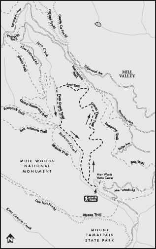
Near the end of Fern Creek Trail you pass a sign marking the border of Muir Woods National Monument. In a few more steps you’re at the base of the Kent Memorial, a very large Douglas fir tree dedicated to the man who was responsible for the creation of this park. Say a few gracious words about Congressman Kent, then head back down the main trail to your starting point.
GOING FARTHER
A slightly longer hike from Muir Woods is a 4.2-mile loop that combines Ocean View, Redwood, Sun, and Dipsea Trails. Follow Ocean View Trail uphill as in the trip above, then turn right on Redwood Trail. Shortly you’ll gain the ocean views you didn’t get on Ocean View Trail. In 1 mile you pass the Tourist Club, a private hiking club. Near there, Redwood Trail connects to Sun Trail, which travels 0.7 mile to a junction with Dipsea Trail. Turn right on Dipsea, which crosses Muir Woods Road and drops back down to the Muir Woods parking lot in 1 mile.