RATING |
|
 |
DISTANCE |
|
8.4 miles round-trip |
HIKING TIME |
|
4.5 hours |
ELEVATION GAIN |
|
800 feet |
HIGH POINT |
|
8,600 feet |
EFFORT |
|
Prepare to Perspire |
BEST SEASON |
|
June to October |
PERMITS/CONTACT |
|
Amador Ranger District, (209) 295-4251, |
|
|
www.fs.fed.us/r5/eldorado |
MAPS |
|
USGS Caples Lake |
NOTES |
|
Dogs allowed; bikes prohibited |
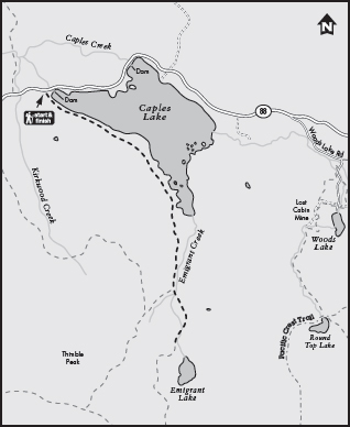
THE HIKE
A surprisingly level trail follows the shoreline of Caples Lake and sections of an old emigrant route to the granite-lined shores of Emigrant Lake.
GETTING THERE
From the junction of Highway 89 and Highway 88 in Hope Valley, drive west on Highway 88 for 13.5 miles to the west side of Caples Lake and the trailhead parking area by the dam (5 miles west of Carson Pass).
THE TRAIL
Although the mileage is substantial along the trail to Emigrant Lake, the grade is so gentle you may find yourself wondering if you are still in the Sierra Nevada. In fact, the trail is basically level for the first 2.4 miles as it edges the southwest shore of Caples Lake, traveling under a shady conifer canopy. A mixed forest of white firs and lodgepole pines frames this large man-made lake, where fishermen ply the waters daily for trophy trout—even in winter when the lake is ice-covered.
At 1.3 miles from the start, you’ll reach a junction with the Historic Emigrant Trail, used by thousands of late-1800s emigrants who were trying to make their way to the Nevada silver mines. Stay straight at this junction and continue along the lakeshore, slowly moving farther away from its edge.

Rockbound Emigrant Lake is set in a classic glacial cirque and surrounded by snowfields long into summer.
Just when you’ve settled into easy-cruising mode, it’s time to get to work. Almost all of the elevation gain on this trail takes place in the last 1.8 miles, starting soon after the trail passes by the south end of Caples Lake. You’ll ascend moderately alongside Emigrant Creek, crossing it once, then march up a final few switchbacks to the lake at 8,600 feet.
The payoff? In the final stretch to the lake’s east shore, the hike returns to the mode of a level stroll. Emigrant Lake is a spectacular sight, set in a classic glacial cirque with steep granite walls rising up to Covered Wagon Peak and Thimble Peak, both higher than 9,500 feet. Snowfields can linger along these granite walls until very late in summer. Swimming in the frigid water, sunbathing, and sceneryadmiring are the preferred activities here, although some anglers may be tempted to throw a line in the water.
GOING FARTHER
If you’d like to learn more about the Historic Emigrant Trail, stop in at the Carson Pass Information Station and ask the docents to direct you to the dirt road just west of the summit, where you can hike through the forest and look for boulders on which the emigrants etched their names.