RATING |
|
 |
DISTANCE |
|
2.4 miles round-trip |
HIKING TIME |
|
1.5 hours |
ELEVATION GAIN |
|
900 feet |
HIGH POINT |
|
9,450 feet |
EFFORT |
|
Moderate Workout |
BEST SEASON |
|
June to October |
PERMITS/CONTACT |
|
Yosemite National Park fee required |
|
|
($20 per vehicle, valid for seven days), |
|
|
(209) 372-0200, www.nps.gov/yose |
MAPS |
|
Yosemite National Park (download at www.nps.gov/yose/planyourvisit/brochures.htm) |
NOTES |
|
Dogs and bikes prohibited |
THE HIKE
The mileage may be short on this hike, but the steep climb up the bald face of this granite dome will make you feel like a real mountaineer.
GETTING THERE
From Yosemite’s Big Oak Flat entrance station on Highway 120, drive southeast 7.7 miles to Crane Flat, then turn left to stay on Highway 120. Drive 39 miles to the Lembert Dome/Dog Lake/Glen Aulin trailhead on the left, in the heart of Tuolumne Meadows. The trail begins near the restrooms.
THE TRAIL
When you see 800-foot-high Lembert Dome from the trailhead and parking area, you’ll never think you can make it to the top. It just seems too big and imposing to be scaled without ropes and carabiners. But although the west side of Lembert Dome is an intimidating sheer face—the playground of technical climbers—the northeast side is gently sloped, and achievable by an easy walk up.
Granite domes, a common geological feature in the Sierra, are essentially large rounded rocks formed by the creation of slowly expanding granite. As the granite expands, cracks form, creating individual layers of rock near the surface. Over time, a process called exfoliation occurs, in which these outer layers of rock break apart and fall off, removing all sharp corners and angles from the rock and leaving a smooth round dome. Lembert Dome is a special kind of dome called a roche moutonée, a French geologic term that designates a dome with one sheer side and one sloping side.
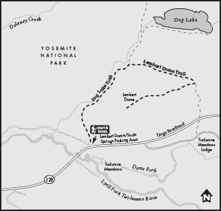
To hike to its summit, take the trail by the restrooms that is signed for Dog Lake and Lembert Dome. In about 300 yards, your trail splits off from the path to Dog Lake. Take the right fork for Lembert Dome and prepare to climb steeply through a lodgepole pine forest. This trail will get your heart pumping as it picks its way up the steep and rocky slope. As you pass underneath Lembert Dome’s west side, you’ll hear the shouts of rock climbers dangling from the granite high above you.
The trail curves around the back (north) side of the dome, then disappears completely on the dome’s hard granite. Simply pick your own route to Lembert Dome’s exposed summit. Some hikers make a beeline for the top; others zigzag their way.
No matter how you get there, the rewards are great. The outstanding view from the top of Lembert Dome, elevation 9,450 feet, takes in all of Tuolumne Meadows and its surrounding peaks. The steep slope of the dome can be downright dizzying, so if you’re afraid of heights, hold on to your hiking partner. The wind often howls on top, adding to the excitement.

Lembert Dome looks imposing from the trailhead, but attaining its summit is a fairly easy climb for most hikers.
On your return from Lembert Dome, make sure you pay close attention at all trail junctions and follow the signs for “Lembert Dome Parking.” Otherwise, you could wind up back at the Tuolumne Meadows horse stables or Tuolumne Lodge instead of at your car. The multiple trail junctions are simple to follow on the way up, but easier to miss on the way down.
GOING FARTHER
After descending to the base of Lembert Dome, continue on the trail to Dog Lake. This will add 0.8 mile to your round-trip.