RATING |
|
 |
DISTANCE |
|
5.0 miles round-trip |
HIKING TIME |
|
2.5 hours |
ELEVATION GAIN |
|
600 feet |
HIGH POINT |
|
7,700 feet |
EFFORT |
|
Moderate Workout |
BEST SEASON |
|
June to October |
PERMITS/CONTACT |
|
Shuttle bus ticket purchase required |
|
|
(see details below), Devils Postpile National Monument, |
|
|
(760) 934-2289, www.nps.gov/depo |
MAPS |
|
Devils Postpile National Monument |
|
|
(download at www.nps.gov/depo) |
NOTES |
|
Dogs and bikes prohibited |
THE HIKE
Containing one of the finest examples of columnar basalt in the world, Devils Postpile National Monument is also home to 101-foot Rainbow Falls and one of the most famous fly-fishing stretches of the San Joaquin River. This hike visits them all.
GETTING THERE
From the town of Mammoth Lakes near U.S. 395, take Highway 203 west for 4 miles, then turn right on Minaret Road (which is still Highway 203). Drive 4.5 miles to the Devils Postpile bus stop across from Mammoth Mountain Ski Area. Purchase an access pass at the Mammoth Mountain Adventure Center ($7 per adult or $4 per child) and board the bus; disembark at the Devils Postpile Ranger Station. If you arrive before 7 a.m. or after 7 p.m. you may drive your own car into the monument.
THE TRAIL
What the heck is the Devils Postpile? Finding the answer requires taking a wonderful walk in Devils Postpile National Monument.
But don’t plan to drive your car to the trailhead. The road into the monument is narrow, steep, and winding, and because of that, all daytime visitors must ride a shuttle bus. You leave your car by Mammoth ski area, purchase an access pass, and board the bus. If you have a reservation to camp in the monument, you will be allowed to drive your own car, but you still must purchase an access pass for your vehicle.
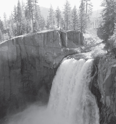
At Devils Postpile National Monument in early summer, Rainbow Falls drops with astounding vigor.
And there’s one more catch: Solitude lovers should plan on a weekday visit, or a very early morning visit (there’s a loophole that allows hikers to drive their own cars before 7 a.m.). The trail to Devils Postpile and Rainbow Falls is incredibly popular; summer weekends bring a continual parade of hikers.
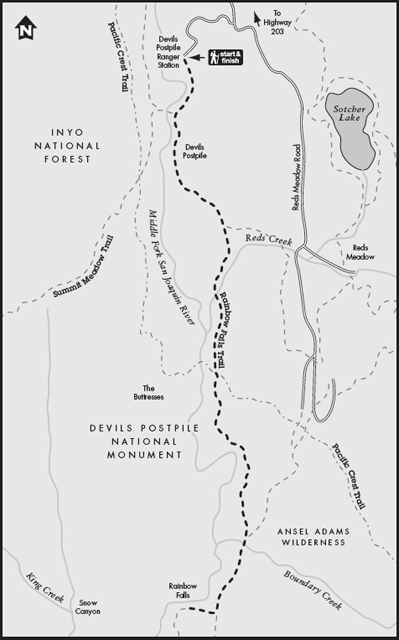
The trailhead is at the ranger station, where the bus drops you off. The Devils Postpile Trail begins in a verdant meadow alongside the headwaters of the San Joaquin River. If you time your trip right, you will be wowed by the meadow wildflowers, especially the masses of shooting stars and Indian paintbrush. In a mere 0.4 mile on a level, easy trail, your curiosity will be sated as you reach the base of the Devils Postpile. What is it? It’s a pile of volcanic rock posts or columns made from lava that was forced up from the earth’s core. At the base of the standing columns is a huge pile of rubble—the crumbled remains of columns that collapsed. Notice the shapes of the various lava columns; some are almost perfectly straight, while others curve like tall candles that have been left out in the sun.
The Mammoth Lakes area is volcano country. Less than 100,000 years ago, lava filled this river valley more than 400 feet deep. As the lava began to cool from the airflow on top, it simultaneously cooled from the hard granite bedrock below. This caused the lava to harden and crack into tall, narrow pieces, forming nearly perfect columns or posts. The Devils Postpile is considered to be the finest example of lava columns in the world.
After examining the base of the Postpile, take the trail on either side of it to its top. Under your feet, the tops of the columns look like honeycomb, or tiles that have been laid side by side. A bonus is the view of the rushing San Joaquin River below.
When you’re ready, return to the base of the Postpile and continue past it on the well-marked trail to Rainbow Falls. You’ll skirt in and out of the monument boundary and Inyo National Forest as the trail descends gently through lodgepole pines. The sound of the San Joaquin River is always apparent, although you won’t see the stream again until you get close to the waterfall.
At a trail junction directing you straight to Rainbow Falls or left to Reds Meadows (many Rainbow Falls hikers start here for a shorter trip), continue straight. After a stream crossing on a two-log bridge, the path begins its final descent to Rainbow Falls. You’ll hear its roar before you see it. If you’re hiking in the late morning on a sunny day, you may get lucky and see Rainbow Falls’ namesake—two big, beautiful rainbows arcing over the falls’ mist. The angle of the midday sun on the water droplets creates the perfect recipe for a rainbow.
Keep walking past the lip of the falls. You’ll see that Rainbow Falls’ drop makes a grand statement, plunging 101 feet over hard rock. The trail has two viewing areas for the falls, about 30 yards apart. A path from the second viewpoint descends granite steps to the base of the falls—definitely worth the steep descent (and climb back up).
GOING FARTHER
Devils Postpile National Monument offers a wealth of trails leading into the Ansel Adams Wilderness. For a longer trip, hike the 7.6-mile Shadow Lake Trail, a serious workout with about 2,000 feet of elevation gain, but offering eye-popping Sierra scenery. For something easier, try the Sotcher Lake Nature Trail, a nearly level 1.2-mile loop around a picturesque, trout-filled lake. Hikers visiting in the evening or early morning may see the lake’s resident beavers at work.