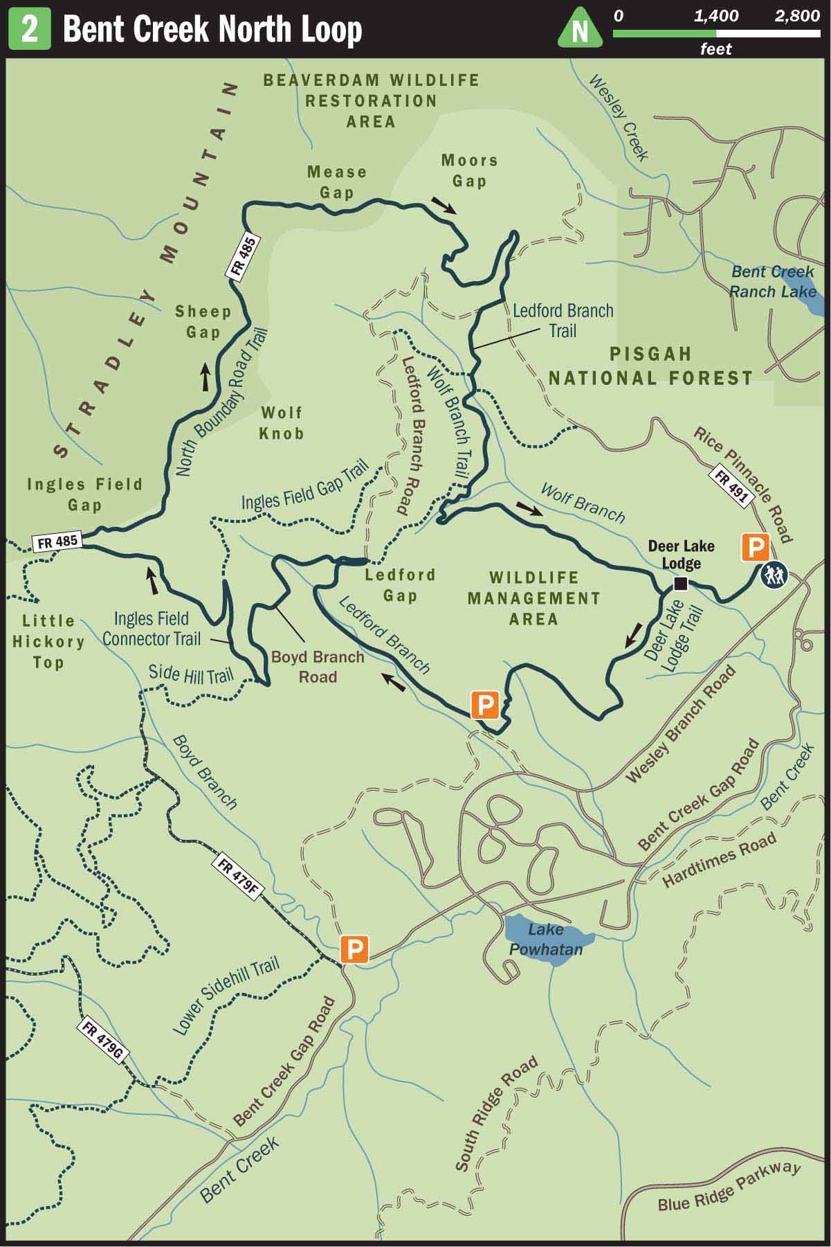
2 Bent Creek North Loop
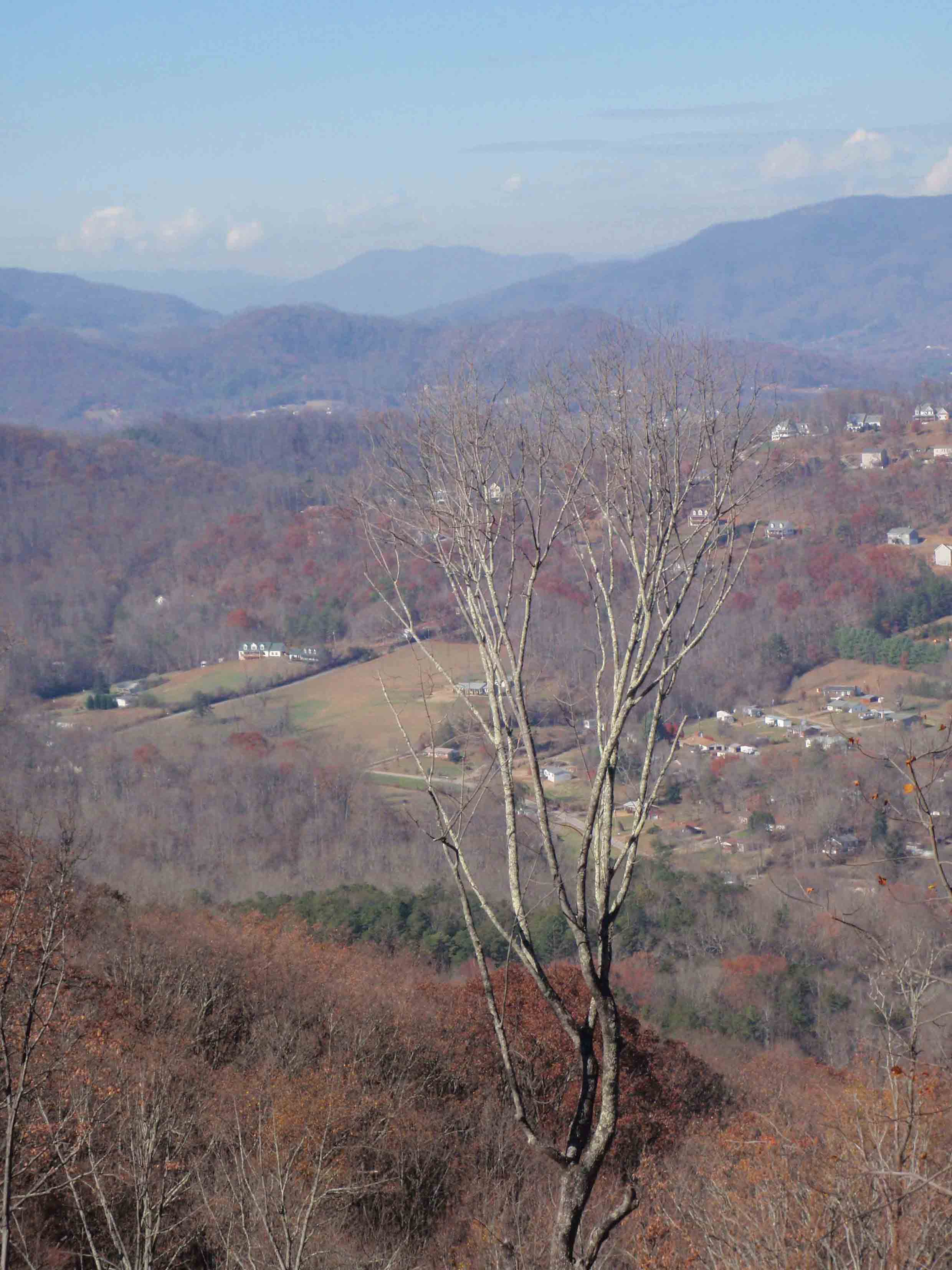
NORTHFACING VIEW FROM INGLES FIELD GAP
SCENERY: 
TRAIL CONDITION: 
CHILDREN:
DIFFICULTY:
SOLITUDE: 
GPS TRAILHEAD COORDINATES: N35° 29.781' W82° 36.933'
DISTANCE & CONFIGURATION: 8-mile loop
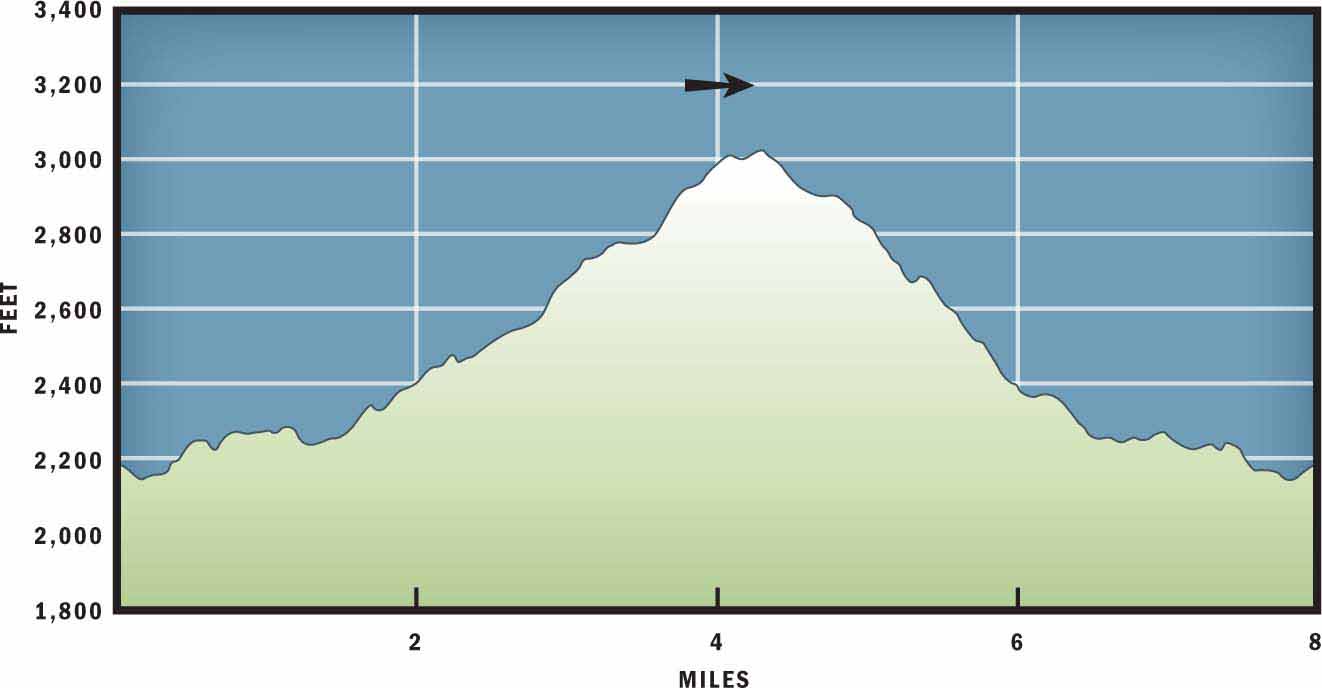
HIKING TIME: 4.5 hours
HIGHLIGHTS: Views of Enka, Candler, and Biltmore Lake development from Ingles Field Gap
ELEVATION: 2,125 feet at Deer Lake near the trailhead to 3,032 feet on Stradley Ridge
ACCESS: Free and always open
MAPS: USGS Bent Creek and Skyland
FACILITIES: Pit toilets at the trailhead
WHEELCHAIR ACCESS: None
COMMENTS: Bent Creek Experimental Forest is open to hunting; especially during deer season, hikers should wear brightly colored clothing and stay on established trails.
CONTACTS: Bent Creek Experimental Forest (828) 257-4832; srs.fs.usda.gov/bentcreek
Overview
Bent Creek North Loop starts at the heart of Bent Creek Experimental Forest and then travels up the slopes of Little Hickory Top to reach the park’s northern boundary. Scenic singletrack and well-maintained dirt roads make up the route. The highlight of the hike is reaching Ingles Field Gap and then tracing along the spine of Stradley Ridge to encounter views of west Asheville and Enka, before looping back downhill to the trailhead.
Route Details
Since 1900, when George W. Vanderbilt bought the land that is today known as Bent Creek Experimental Forest, the property has been utilized primarily to grow and cultivate trees. However, before 1900 the Bent Creek tract was inhabited by early Western North Carolina settlers and used as farmland. The early mountaineers’ impact is still felt at Bent Creek as many of the trails and dirt roads follow the horse paths that led to and from former homesteads and pastures. Furthermore, many of the trails in Bent Creek are named after the landowners that dwelled on the property 200 years ago.
This hike starts off of FR 491 at Rice Pinnacle Trailhead, named after the Rice family who originally developed the area. At the west end of the parking lot there is a wooden information kiosk where the trail begins. Follow the orange-blazed Deer Lake Lodge Trail into the forest. At the very start of the hike, the trail is partially paved but in poor condition and primarily overrun with dirt and pine needles.
Hiking down the path, you will cross a wooden bridge and then continue past a picnic bench and shed. At 0.3 miles you will arrive at a trail junction. (Pay particular attention to the junction, because this is where the loop portion of the hike will conclude before returning to the trailhead.) Turn left at the intersection to remain on Deer Lake Lodge Trail. As you continue uphill, and underneath a power line, you will notice that this is a popular trail for mountain bikers to ride because of the opportunity to “get air” on the bumps in the trail.
After hiking 0.6 miles you will come to the top of a hill, where the natural tendency is to remain on the wide trail that continues straight. However, you will want to stay alert and veer left (southwest) on a singletrack path to stay on Deer Lake Lodge Trail. Eventually the path will terminate at Ledford Branch Trailhead. There you will turn right and hike northwest on the well-maintained Ledford Branch dirt road.
Ledford Branch is named for Billie Ledford, who once had a cabin near the headwaters. The trickling creek will cross under the road a handful of times before you arrive at Ledford Gap. At Ledford Gap, veer left to remain on the dirt road that now becomes known as Boyd Branch Road.
Boyd Branch Road offers a gentle uphill climb. At mile 2.6 you will come to the top of a hill where the trees to the south have been cleared. At this point, instead of following the road downhill, turn right and hike northwest on the Ingles Field Gap Connector. This singletrack marks the beginning of a challenging uphill climb. Stay on the connector trail for 0.3 miles to reach Ingles Field Gap Trail; take a left (west) and continue hiking uphill. The trail briefly levels out before one last steep push to the ridgeline.
Ingles Field Gap is on Stradley Mountain Ridge and is named after Mitch Ingle, who cleared and farmed the land before the Vanderbilts bought the property. The gap reveals views to the north toward Enka, Candler, and the Biltmore Lake development. To continue the hike, turn right (north) on North Boundary Road. You will briefly gain elevation and then enjoy a pleasant downhill journey as the road contours the ridgeline down to its start in the valley.
At mile 5.8 Ledford Branch Road will intersect North Boundary Road. Take a right on Ledford Branch Road and then in another 50 feet, turn left onto Ledford Branch Trail. This trail can be especially muddy and wet after a heavy rain, but bridges and water bars have been added to the trail in recent years to help alleviate this problem. After hiking 0.6 miles on Ledford Branch Trail, turn left on the yellow-blazed Wolf Branch Trail. Follow Wolf Branch Trail back to Deer Lake Lodge Trail. Turn right on Deer Lake Lodge and soon you will arrive back at your first trail junction. Be sure to veer left and follow the paved Deer Lake Lodge Trail back across the wooden bridge to conclude your hike at the Rice Pinnacle Trailhead.
Nearby Attractions
The west end of Wesley Branch Road terminates at Lake Powhatan Recreation Area, which offers overnight camping, a fishing pier, and seasonal swimming. The day-use fee is $5 per vehicle, and overnight rates start at $17 per person. Facilities include flush toilets, showers, and picnic tables.
Directions
From I-26 take Exit 33 and turn left onto NC 191/Brevard Road. Travel 1.9 miles and then turn right onto Bent Creek Ranch Road. In 0.2 miles the road makes a sharp left-hand turn and becomes Wesley Branch Road. Follow Wesley Branch Road 1.6 miles and then turn right on Rice Pinnacle Road. The trailhead and parking area are located 100 yards to the left.