3 Bent Creek West Loop

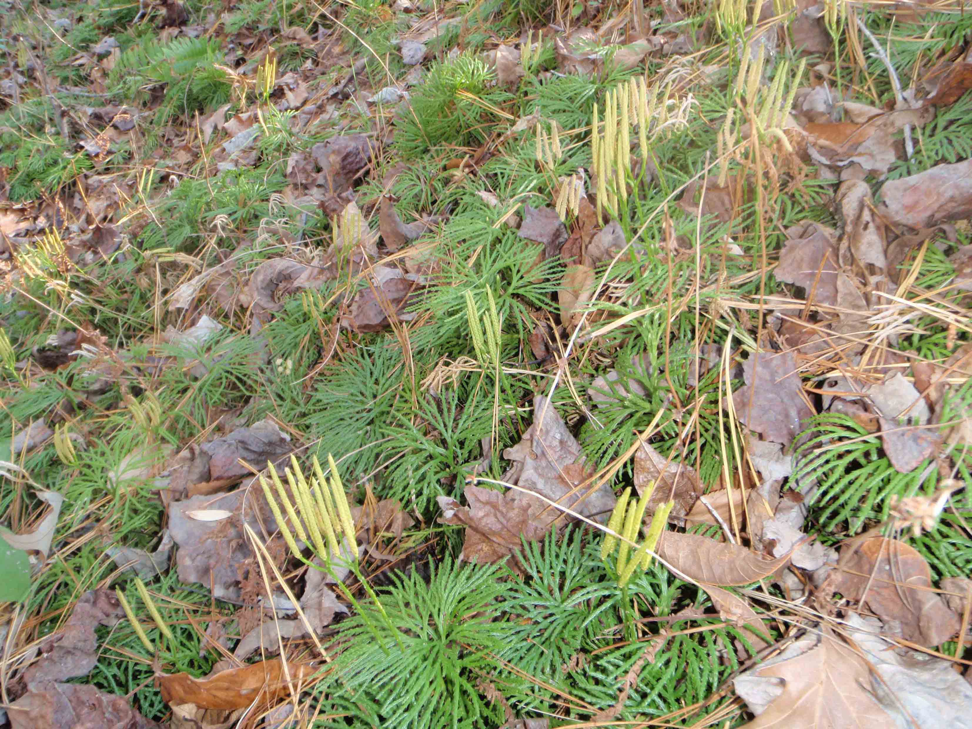
LYCOPODIUM PUSHES ITS WAY UP THROUGH FALLEN LEAVES.
SCENERY: 
TRAIL CONDITION: 
CHILDREN: 
DIFFICULTY: 
SOLITUDE: 
GPS TRAILHEAD COORDINATES: N35° 28.903' W82° 38.113'
DISTANCE & CONFIGURATION: 7.7-mile loop
HIKING TIME: 4.5 hours
HIGHLIGHTS: A mix of challenging forested trails and gently sloped historic roadbeds
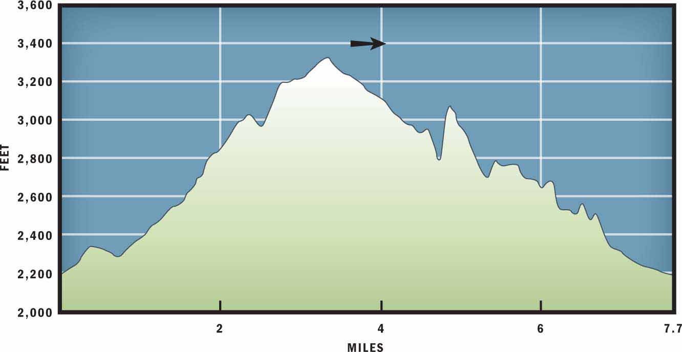
ELEVATION: 2,192 feet at trailhead to 3,330 feet on Stradley Mountain
ACCESS: Free and always open
MAPS: Bent Creek and Skyland
FACILITIES: None
WHEELCHAIR ACCESS: None
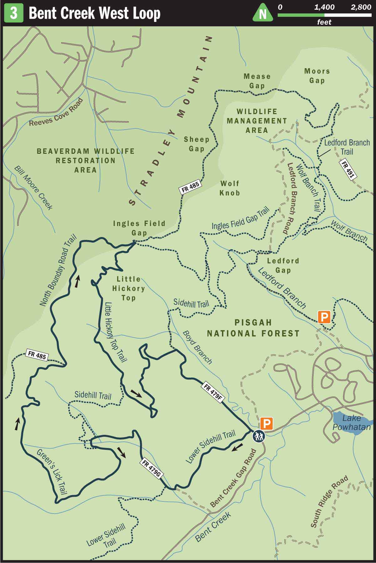
COMMENTS: Before accessing the western, less-traveled portion of Bent Creek, pick up a map at Hardtimes Trailhead Information Kiosk or print one from cs.unca.edu/nfsnc/recreation/bent_creek_trail_map.pdf
CONTACTS: Bent Creek Experimental Forest (828) 257-4832; srs.fs.usda.gov/bentcreek


Overview
This loop explores the western portion of Bent Creek, which is traveled mostly by mountain bikers. But don’t let the fat-tire enthusiasts keep you off the trails. You’ll enjoy terrific views from Stradley Mountain, and there’s plenty of room on the trails for everyone. This route offers a diverse range of technical singletrack trail, old roadbeds, and well-maintained dirt roads. A strenuous climb up Green’s Lick Trail will reveal views of west Buncombe and south Asheville. From Ingles Field Gap, a gentle downhill stroll will lead back to your car at the trailhead.
Route Details
For many local hikers, Bent Creek Experimental Forest ranks the highest both in convenience and confusion. The intertwining trail system can easily make a veteran hiker feel turned around. But because it is so close to town, it is worth traveling back to the forest multiple times to explore the tangled web of dirt roads and hiking paths.
While most hikers choose to explore the trails near Wesley Branch Road, this hike’s trailhead is located past Lake Powhatan off the winding shoulder of Bent Creek Gap Road. This starting position allows the hiker to explore the more remote western portion of the forest. To stress a point noted above: be sure to bring a map with you or pick one up at the Hardtimes Trailhead before starting your hike at Boyd Branch Road.
To begin the hike, walk northwest on Boyd Branch Road (FR 479F). Pass the gate at the mouth of the road and then turn left onto Lower Sidehill Trail. This singletrack trail gently meanders through a forest of hardwood trees that include poplar, hickory, and oak as well as white pine, pitch pine, and other conifers. After 0.3 miles the trail enters a small clearing. These clearings would have been used for homesites and farmland before George W. Vanderbilt bought the land for forestry purposes at the turn of the 20th century. Another such field occurs at mile 0.6, before the trail pops out at a dirt road.
Turn right on forest service road 479G and continue on a gentle uphill slope, parallel to Laurel Branch Creek. After 0.5 miles the road seemingly terminates, but a narrow trail leading west continues into the forest. Follow the yellow-blazed Sidehill Trail into the woods, but then take an immediate left onto Green’s Lick Trail. This trail quickly crosses over three seasonal creeks and then begins a challenging uphill climb toward Hickory Top.
The first mile on Green’s Lick Trail will test your lungs and calf muscles as the path quickly gains elevation. However, after climbing above 3,000 feet, the technical footing eases when the trail joins an old roadbed and continues a steady ascent toward the ridgeline. If you are hiking this trail during hunting season, be sure to wear bright clothing, as motivated deer hunters often travel to this end of the forest to avoid the copious bikers and hikers near the main arteries of Bent Creek.
After 2.2 total miles on Green’s Lick Trail, the path terminates at North Boundary Road. At 3,330 feet above sea level, this is the highest trail intersection in Bent Creek. Turn right onto North Boundary Road. This forest road is especially rewarding in the wintertime, when bare trees reveal glimpses of the Biltmore Estate to the southeast.
The route now follows a gradual descent, before crossing the ridgeline in a grassy saddle. When you cross over the saddle, at mile 4, you will temporarily leave the south side of the ridge and as a result you will be able to view Wise Knob and Biltmore Lake to the north. The trail continues descending on the north side of the ridge until it reaches Ingles Field Gap, where it once again crosses over to the south side of the mountain. From Ingles Field Gap, you will need to cut back hard right onto Little Hickory Top Trail and hike west and uphill.
After a short climb up the slopes of Little Hickory, a knob that used to be known for its hickory trees and squirrel hunting, the path once again starts to descend. The trail now follows an old roadbed, and Little Hickory Top Trail veers off unnoticed to the left and the main path becomes Sidehill Trail. At mile 5.7 Sidehill Trail splits; veer left onto the lower trail and continue following it southeast and then to the north as it makes a large bend to connect with Boyd Branch Road. At the forest service road turn right and follow it 0.9 miles along the banks of Boyd Branch creek back to your car at the southern terminus at Boyd Branch Road.
Nearby Attractions
The west end of Wesley Branch Road terminates at Lake Powhatan Recreation Area, which offers overnight camping, a fishing pier, and seasonal swimming. The day-use fee is $5 per vehicle, and overnight rates start at $17 per person. Facilities include flush toilets, showers, and picnic tables.
Directions
From I-26 take Exit 33 and turn left onto NC 191/Brevard Road. Travel 1.9 miles and then turn right onto Bent Creek Ranch Road. In 0.2 miles the road makes a sharp left-hand turn and becomes Wesley Branch Road. Drive 2.1 miles on Wesley Branch Road, following the signs toward Lake Powhatan. Then, just before the entrance to the recreational area, turn right onto unpaved Bent Creek Gap Road. Follow the winding road 1 mile to the intersection of Boyd Branch Road and Bent Creek Gap Road. Park on the left shoulder of the road near the Campground Connector Trail and begin your hike at the gate that marks the entrance of Boyd Branch Road.