10 Craggy Gardens and Craggy Pinnacle

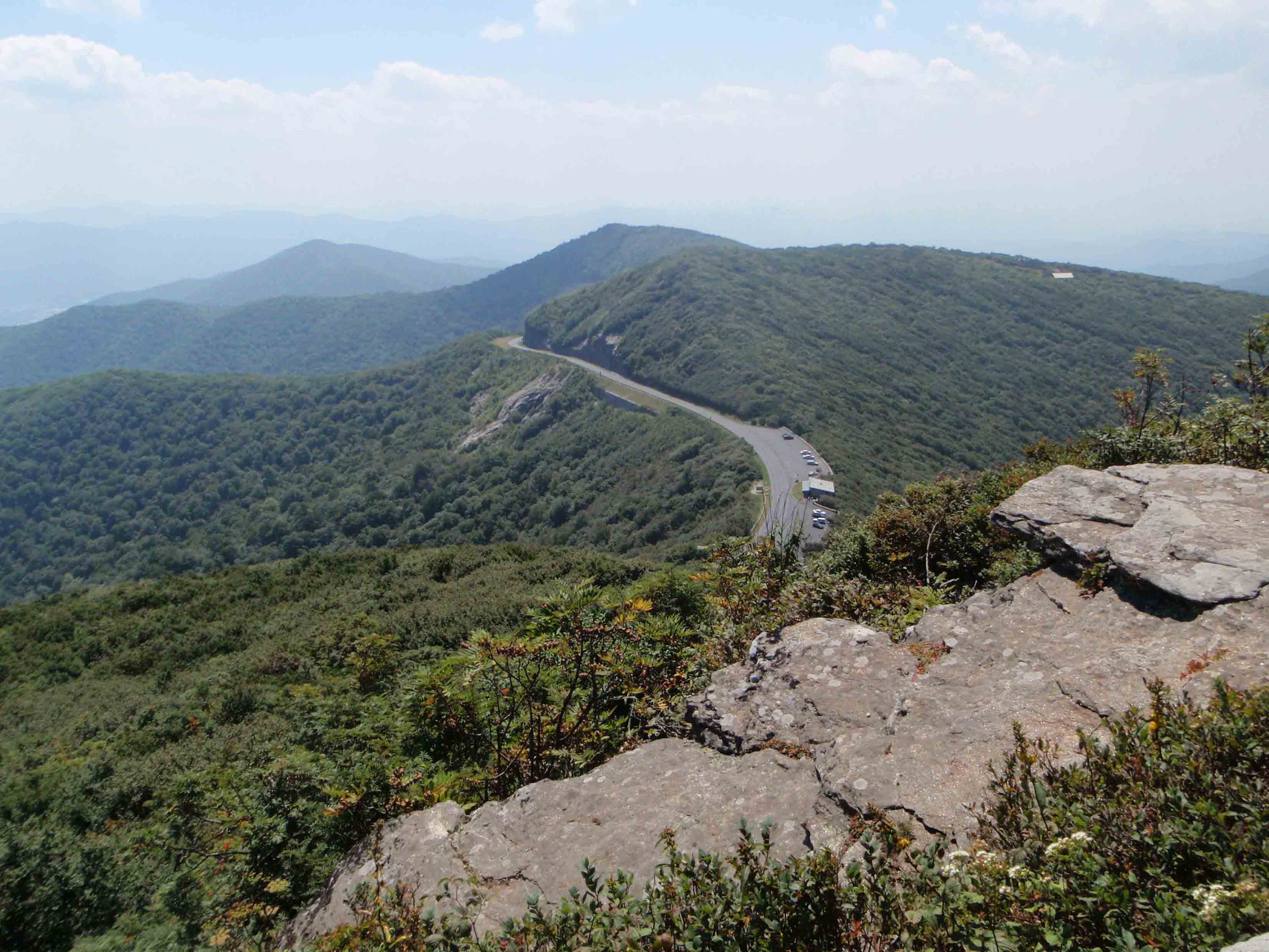
A VIEW OF THE BLUE RIDGE PARKWAY FROM CRAGGY PINNACLE
SCENERY: 
TRAIL CONDITION: 
CHILDREN: 
DIFFICULTY: 
SOLITUDE: 
GPS TRAILHEAD COORDINATES (Craggy Gardens Visitor Center): N35° 42.256' W82° 22.409'
GPS TRAILHEAD COORDINATES (Craggy Pinnacle Parking): N35° 42.010' W82° 22.779'
DISTANCE & CONFIGURATION: 2-mile out-and-back (not counting car shuttle)
HIKING TIME: 1.5 hours
HIGHLIGHTS: Panoramic views and blooming rhododendron
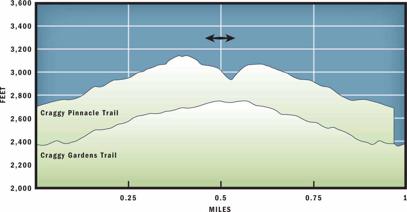
ELEVATION: 5,481 feet at the visitor center to 5,877 feet at Craggy Pinnacle
ACCESS: Free and always open, but vehicle access to this hike is unavailable when the Blue Ridge Parkway is closed.
MAPS: USGS Craggy Pinnacle
FACILITIES: Restrooms and water at the Craggy Gardens Visitor Center
WHEELCHAIR ACCESS: Yes, at the visitor center
COMMENTS: Combine two neighboring trails to complete this hike, with a brief car shuttle to connect the hikes.
CONTACTS: Blue Ridge Parkway (828) 298-0398; nps.gov/blri


Overview
The Great Craggy Mountains feature the closest balds to Asheville, and those mountain summits reveal some of the best views in Western North Carolina. This combo hike will take you on two short out-and-back trails. On the first segment, you will follow the Mountains to Sea Trail (MST) to the rhododendron-dotted summit at Craggy Gardens. Then, after a short car shuttle, the second portion of the hike sends you to the top of Craggy Pinnacle for great views of the North Fork Reservoir and neighboring Craggy Dome.
Route Details
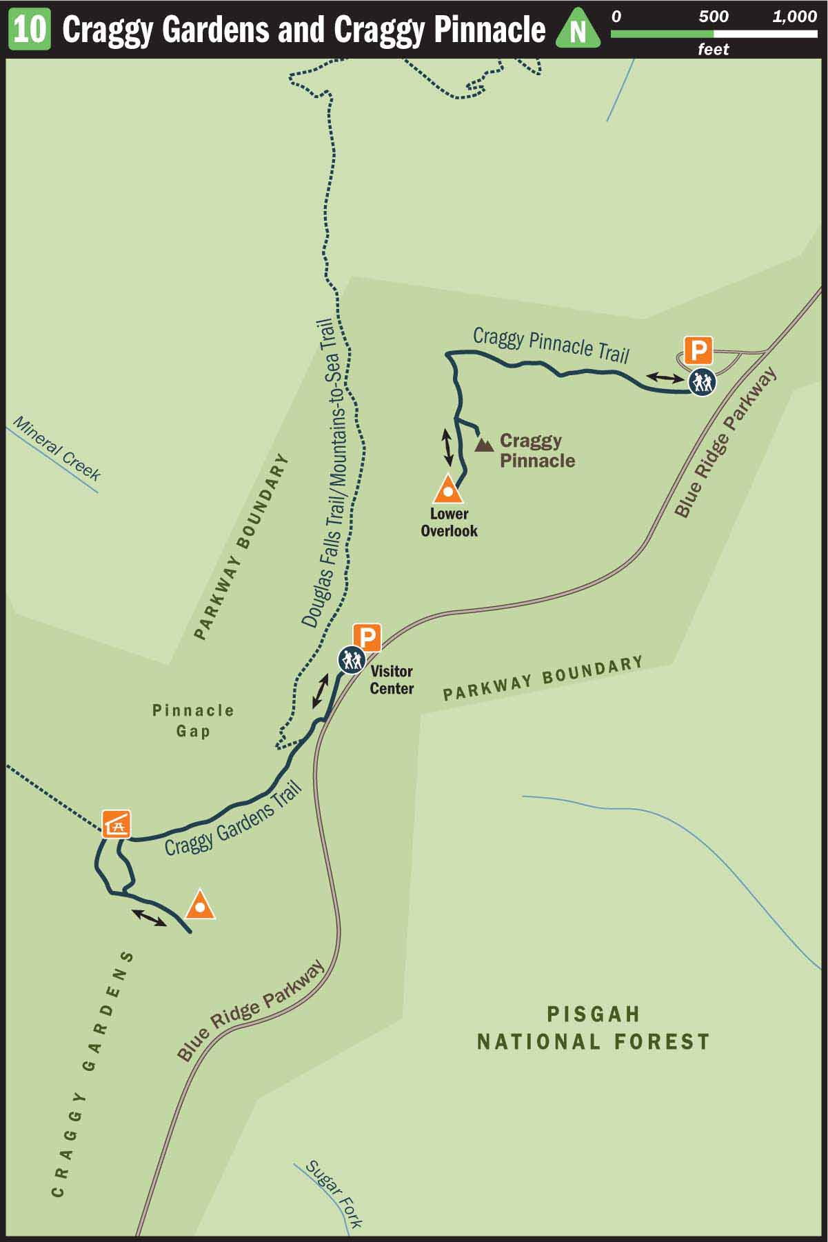
Begin at the Craggy Gardens Visitor Center. In fact, before starting your hike, you should allow extra time to visit this outpost to learn more about the Craggy Gardens area, view a local map, and talk to the knowledgeable attendant working at the parkway store.
When you leave the visitor center, head southwest along the paved sidewalk to the end of the car park. There the sidewalk terminates and becomes a dirt spur trail leading into the forest. Turn right on the trail and follow it 0.1 mile to an intersection with Douglas Falls Trail and the MST. Turn left and hike uphill on the white-blazed MST. You will immediately notice the first of five informational plaques to your left. Each of these plaques that line the path to Craggy Gardens reveals a new and interesting fact about the surrounding habitat.
The trail leading to the top of the mountain is a dark green tunnel of birch, ash, oak, and buckeye trees. The trail is covered so well that it comes as a surprise when you suddenly step out of the tree cover into the open air at Craggy Gardens. The first thing you will see on the bald is the large open-air pavilion. This is a great place to picnic or share a quick snack before exploring the bald.
Many scientists debate how the mountaintop balds first appeared in this region. One theory suggests that the balds were left after a devastating wildfire destroyed the mountaintop vegetation. Other researchers believe that balds were created by Native Americans to attract certain animals. Today, the forest service maintains the balds by utilizing controlled burns or grazing livestock.
When you are ready to venture out onto the bald, walk to the south end of the pavilion and follow a maintained, but unmarked, trail to the left. This trail wanders across the exposed bald and through the low-lying shrubs that grow sparsely on the mountain. At the east end of the bald, the path terminates at a rock wall. On a clear day this vista provides stunning views of the North Fork drainage basin, Mount Graybeard, and the Black Mountains. By retracing your steps and taking the first available right, you can complete a loop on the bald and return to the Craggy Gardens Pavilion.
To access the next (Craggy Pinnacle) portion of this hike, you will need to backtrack to the Craggy Gardens Visitor Center and then drive your car north on the parkway for 1 mile through the Craggy Pinnacle Tunnel to the Craggy Dome viewing area and park in the lot on the left. The hike begins at the upper portion of the parking lot. A trail marker suggests that it is a 0.7-mile trail, but to visit both the upper summit and lower viewing area, it is closer to a 1-mile round-trip hike.
Before heading into the forest on the singletrack trail, take a minute to look to the north and view Craggy Dome. At 6,105 feet, Craggy Dome is the tallest peak in the Great Craggy Mountains.
The ascent to Craggy Pinnacle starts gradually and increases in difficulty as you approach the summit. A tunnel of rhododendron branches covers the first part of the trail. Both Craggy Gardens and Craggy Pinnacle are known for their early summer explosion of rhododendron blossoms. The pink and purple flowers start to bloom in June and typically last until July.
At 0.2 miles the rhododendrons give way to wind-stunted birch trees, and you will notice several intriguing root formations that line the trail. The gnarled trees seemingly grow out of rocks, and each protruding root formation has its own unique features and shape. For the next 100 yards, the twisted exhibition lines the trail like pieces of art in a museum.
Beyond the peculiar birch trees, you will pass a seasonal spring on the left, and the grade of the trail will increase. At 0.3 miles you will arrive at a trail junction that divides the upper summit from the lower overlook. Veer left and travel another few hundred yards to the upper summit. The 360-degree views from the top of the mountain showcase Craggy Dome to the north and Craggy Gardens to the south. On the east side of the mountain you can see the North Fork Reservoir, Asheville’s water source, at the base of the Black Mountain range. To the west lie Pisgah, Black Balsam, Cold Mountain, and on a very clear day you may be able to pick out the faint ridge of the Smoky Mountains.
When you leave the summit, backtrack down the trail, but don’t return to the trailhead before first turning left on the short side trail to the lower overlook. There, once again, great views reward you to the south and east, and you are able to observe large exposed rocks jutting out from the side of the mountain. After taking one last look at Craggy Gardens in front of you and Craggy Pinnacle above you, enjoy the short jaunt down the mountain to reach the trailhead and return to your car.
Directions
For part one of this two-pronged hike, take the Blue Ridge Parkway north from Asheville. Drive to milepost 364, approximately 18 miles from Asheville, and park at the Craggy Gardens Visitor Center to the left of the parkway. As noted above, for part two of the outing, drive 1 mile north on the parkway to the Craggy Dome viewing area and park in the lot on the left.