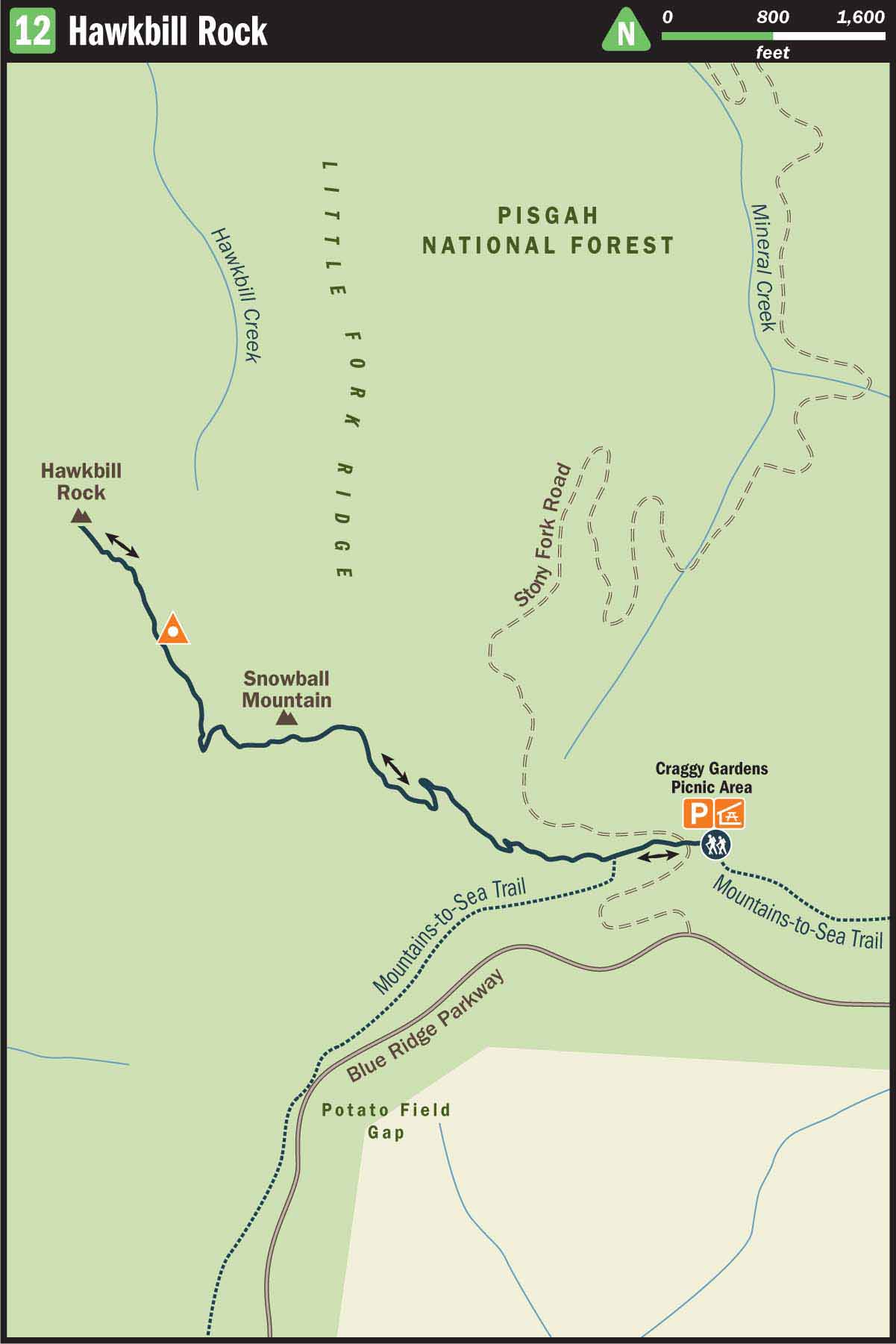
12 Hawkbill Rock
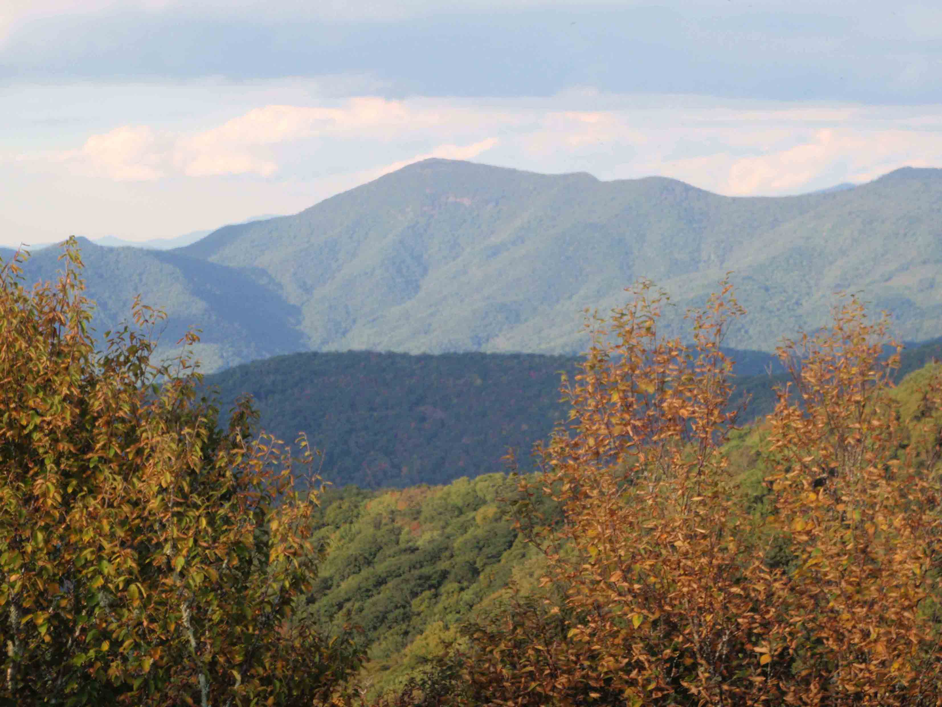
A VIEW FROM THE WEST SLOPE OF SNOWBALL MOUNTAIN
SCENERY: 
TRAIL CONDITION: 
CHILDREN:
DIFFICULTY: 
SOLITUDE:
GPS TRAILHEAD COORDINATES: N35° 41.998' W82° 23.905'
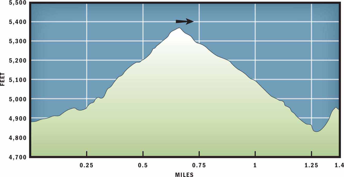
DISTANCE & CONFIGURATION: 2.8-mile out-and-back
HIKING TIME: 2 hours
HIGHLIGHTS: Outstanding views from Hawkbill Rock
ELEVATION: 4,917 feet at trailhead to 5,374 feet on top of Snowball Mountain
ACCESS: Free and always open, but vehicle access to this hike is unavailable when the Blue Ridge Parkway is closed.
MAPS: USGS Craggy Pinnacle
FACILITIES: Picnic tables, outdoor grills, and restrooms at Craggy Gardens Picnic Area
WHEELCHAIR ACCESS: None
COMMENTS: This hike can be lengthened by walking 1.7 miles past Hawkbill Rock to Little Snowball Mountain. However, if you plan to journey past Hawkbill Rock, bring a good map, as the trail becomes confusing and overgrown.
CONTACTS: Blue Ridge Parkway (828) 298-0398; nps.gov/blri
Overview
This trail starts near the entrance of the Craggy Gardens picnic area and follows the Mountains to Sea Trail (MST) briefly before veering north on the Snowball Mountain Trail. There is a short but difficult climb to the top of Snowball Mountain followed by a moderate descent down the peak’s narrow ridge. The highlight of the hike is the dramatic view from Hawkbill Rock. However, you must first overcome a challenging but enjoyable rock scramble in order to access the scenic outcropping.
Route Details
Look for the trailhead before a park gate that leads to Craggy Gardens Picnic Area. It is located at a 90-degree bend in the road, near roadside parking, and to the left of a dirt turnoff for Stoney Fork Road.
Begin the hike by following the white-blazed MST west and slightly uphill. After 0.1 mile the singletrack trail will split in two. The white-blazed MST continues on the left toward Lane Pinnacle, and the yellow-blazed Snowball Mountain Trail veers right. Take the less-traveled Snowball Mountain Trail. Because this path does not receive as much foot traffic as other trails in the area, there may be heavy underbrush encroaching upon the narrow dirt treadway. If you are hiking this route in the summer or fall, it is a good idea to wear pants in order to protect your legs from stray thorns, nettles, and poison ivy.
After departing the MST, you will start a set of switchbacks leading to the summit of Snowball Mountain. The steady incline offers a short but challenging 0.5-mile climb. The top of Snowball Mountain is covered with oak, beech, and yellow birch trees. There are glimpses from the summit of neighboring mountains, but the best views are not revealed until November when the leaves fall.
If the parkway remains open late into the season, and you are able to hike this trail after peak-leaf season, then you will have an easy time identifying the beech trees. Beech trees have leaves that are marcescent, meaning that they do not naturally detach in the fall and, instead, stay on the tree until strong winds, rains, or heavy snow cause them to fall. Their translucent brown hue often glimmers in shades of copper and gold when the winter sun pierces through the bare canopy of the forest.
Descending the northwest spine of Snowball Mountain, you will continue through a dense hardwood forest that exhibits some relatively mature chestnut trees (up to 10 feet tall). Relative is the key word, since chestnut trees rarely live more than a few years due to the deadly chestnut blight. You may also recognize a few buckeye trees lining the path or else discover their shiny brown and tan fruits lining the trail in the fall.
Once you have hiked 1 mile, you will reach what seems to be a modest viewpoint. However, one step up onto a neighboring rock will allow you to see over the shrubs and out across Big Fork Ridge, Bullhead Ridge, and Locust Ridge to the north. After leaving the overlook, continue downhill to a nearby gap. Upon reaching the brief dip in the ridgeline, you will face your final ascent to Hawkbill Rock. This last climb will force you to do some rock scrambling as the soft earthen path transitions into angled granite.
You will have to use both of your hands and both of your feet to navigate this steep, exposed section. And although your eyes will be focused on the trail, be sure to look to your left, as the main outcropping of Hawkbill Rock is hidden from the path. The best way to find this majestic viewpoint, located 1.3 miles from the start of the trail, is to stop hiking just before the trail reenters the forest. There is a slight rise in the granite rock to your left. If you take a few steps over to this rise, you will be able to look below and see the smooth rock slab known as Hawkbill Rock. Carefully navigate down to this overlook and enjoy the fantastic view of Reems Creek Valley.
Drainage running off the side of Snowball Mountain and Rocky Knob creates Reems Creek, which wanders about 20 miles through the fertile valley below before ending at the French Broad River. This region was one of the first areas of Western North Carolina to be settled by Europeans. It also was the birthplace of Zebulon Vance, a North Carolina governor, U.S. senator, and an important Confederate leader during the Civil War.
When you are ready to leave Hawkbill Rock, backtrack to the trailhead on the Snowball Mountain Trail.
Nearby Attractions
The Craggy Gardens Picnic Area, at the end of Craggy Garden Picnic Area Road, offers picnic tables, outdoor grills, and restroom facilities.
Directions
Follow the Blue Ridge Parkway north to mile marker 367.5 and turn left onto Craggy Gardens Picnic Area Road. The closest parking to the trailhead is located off the side of the Craggy Gardens Picnic Area Road, at a sharp right-hand turn and just before a park gate. If there are not available spaces alongside the road, continue to the main parking and picnic area and begin your hike by backtracking alongside the road.