17 Mount Mitchell High Loop

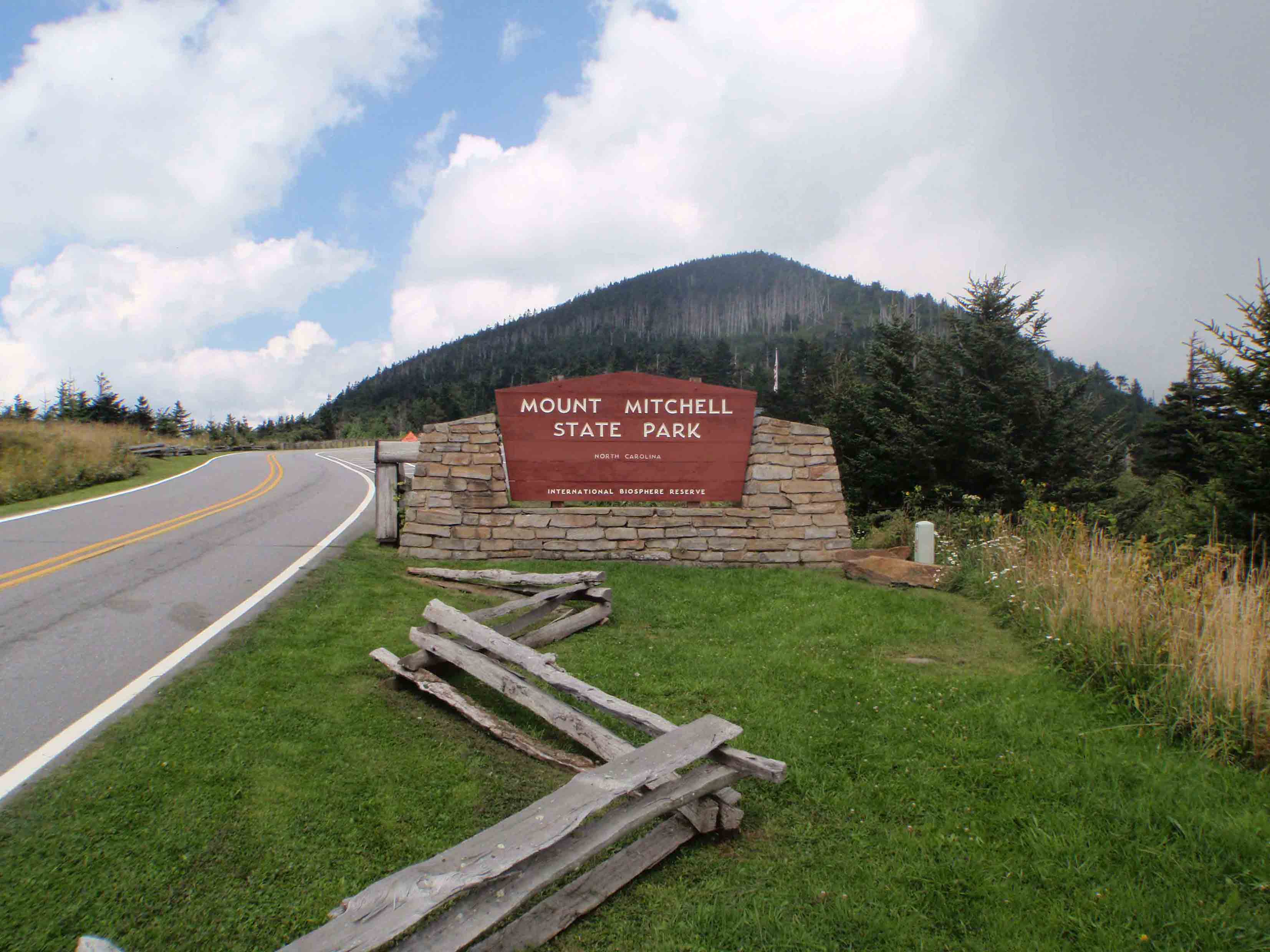
WELCOME TO MOUNT MITCHELL STATE PARK
SCENERY: 
TRAIL CONDITION: 
CHILDREN: 
DIFFICULTY: 
SOLITUDE: 
GPS TRAILHEAD COORDINATES: N35° 44.720' W82° 16.654'
DISTANCE & CONFIGURATION: 4-mile loop
HIKING TIME: 2.5 hours
HIGHLIGHTS: Mount Mitchell, the highest mountain east of the Mississippi River
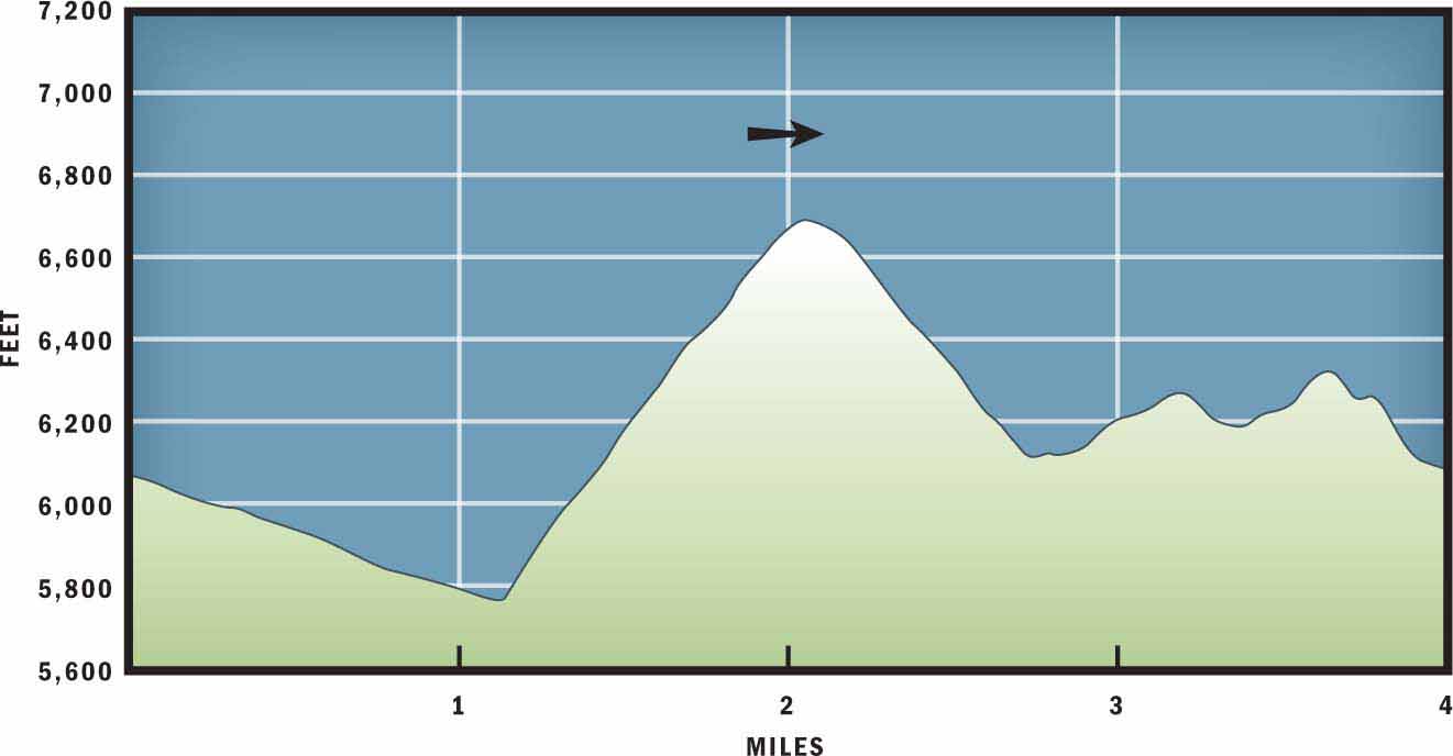
ELEVATION: 6,072 feet at trailhead to 6,684 feet at Mount Mitchell summit
ACCESS: Mount Mitchell State Park is open year-round, 8 a.m.–sunset. Vehicle access is limited in winter due to Blue Ridge Parkway closures.
MAPS: USGS Mount Mitchell
FACILITIES: Restrooms and park information at the trailhead; restrooms, gift shop, and snack bar 0.2 miles beneath the summit.
WHEELCHAIR ACCESS: Yes, on a 0.2-mile trail from the upper parking lot to the summit
COMMENTS: This hike is rated for moderate distance and elevation gain, but if you are not acclimated to elevations above 5,000 feet this hike will feel strenuous. Plan accordingly.
CONTACTS: (828) 675-4611; ncparks.gov/Visit/parks/momi


Overview
In 1835 professor, explorer, and scientist Elisha Mitchell measured the mountain—that in the future would be named in his memory—and proclaimed it to be the tallest summit between the Gulf of Mexico and the White Mountains of New Hampshire. This discovery brought researchers, commerce, and tourists to the Black Mountain Range. Today, we know that Mount Mitchell, at 6,684 feet, is the tallest mountain east of the Mississippi River. The Mount Mitchell High Loop follows an old railroad bed to the top of the mountain, where Elisha Mitchell is buried, and then returns to the trailhead through a dense Fraser fir forest.
Route Details
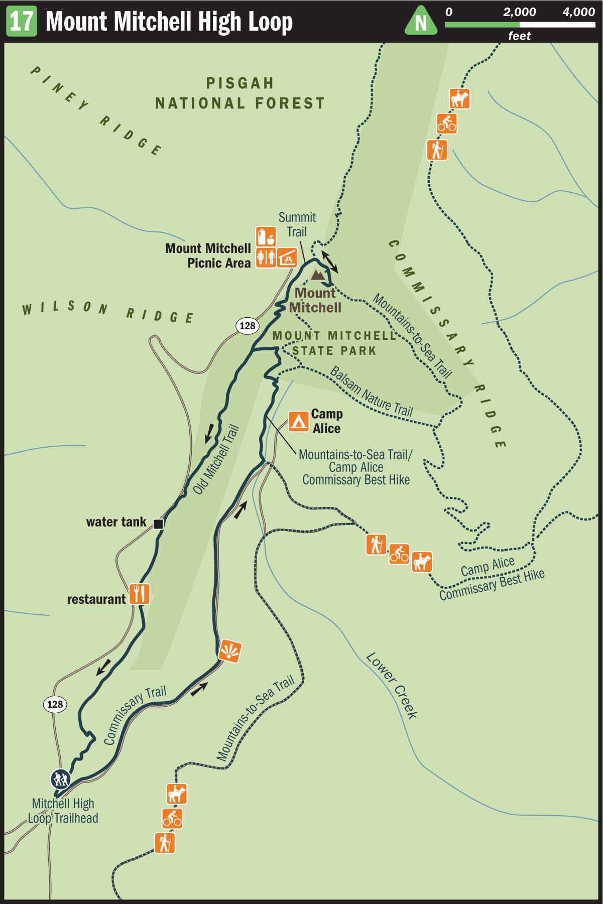
To begin the hike, park at the Mount Mitchell Park Office and Information Center and walk behind the park office on a paved road to a gated gravel road. This is the start of the Commissary Trail. The Commissary Trail follows an old railroad bed that was built at the turn of the 20th century. The railroad ran west to Pensacola, North Carolina, and south to Black Mountain, North Carolina. After two decades of logging, most of the Black Mountain slopes were barren.
In 1915, in an attempt to protect the remaining trees on top of Mount Mitchell, the North Carolina State Legislature designated the mountain and surrounding area as the first state park in North Carolina. Soon after, the logging train system converted to passenger rail that brought tourists to the top of the mountain. In 1922 the railroad bed was transformed into a toll road. The toll road remained the state park’s main access road until the Mount Mitchell section of the Blue Ridge Parkway was built in 1939.
Today, the old toll road is lined with blueberry bushes, blackberry bushes, and stalks of goldenrod that attract butterflies in the late summer. After you hike 0.6 miles, the view from the old toll road opens up and on a clear day you can see the summit of Mount Mitchell and the Commissary Ridge skirting off to its right.
After you complete 1.2 miles on the Commissary Trail, you will reach a stream that runs across the gravel road. Just before the stream is a trail junction. Turn left and follow the combined Mountains to Sea Trail (MST) and Camp Alice Trail uphill into the dense forest. There, the heavy moss, dark canopy, and copious evergreens more closely resemble northern New England than the southern Appalachians. And the ensuing shortness of breath reminds you that you are rising above 6,000 feet.
In 0.4 miles the Old Mitchell Trail intersects the MST. Continue uphill on the MST, but take special note of the yellow-blazed Old Mitchell Trail, as it will serve as your return route to the trailhead. Leaving the Old Mitchell Trail behind, you will switchback up the mountain several more times before passing an unmarked campground spur to the left. There the path veers north and starts ascending the ridgeline. In another 0.2 miles the dirt path terminates at a paved trail. Follow the paved trail uphill 0.1 mile to the top of Mount Mitchell.
Congratulations! You have now climbed to the top of the tallest mountain in the Eastern United States. Take a moment at the top to catch your breath and enjoy the view. You may also want to take a moment beneath the observation tower to visit the grave of Elisha Mitchell, an important figure in the history of Mount Mitchell.
An ordained minister, Mitchell was also a professor at the University of Chapel Hill. The North Carolina Geological Survey brought him to the Black Mountain Range, and in 1835 he followed scientific protocol to measure and conclude that Mount Mitchell was the highest mountain between the Gulf of Mexico and Canada. However, in 1855 U.S. Senator Thomas Clingman, a former student of Elisha Mitchell’s, disputed his professor’s claim. Clingman pronounced that Mitchell had mistakenly measured another peak along the Black Mountain Crest and named it as the tallest mountain. He suggested that he was the first to accurately measure the height of Mount Mitchell and confirm it as the tallest mountain in the east.
The back story is that Elisha Mitchell had returned to the Black Mountain Range in 1857 to validate his research, and he tragically lost his life at modern-day Mitchell Falls, when he slipped on a wet rock and fell to his death. Today, Elisha Mitchell and Thomas Clingman are both recognized as pioneers, and their legacies are remembered by respective 6,000-foot peaks named in their honor.
Leaving the summit, retrace your steps on the MST downhill through the forest to the junction with the Old Mitchell Trail. Turn south on the Old Mitchell Trail and follow the yellow blazes painted on the trunks of sweet-smelling Fraser fir trees. The benefit of returning to the trailhead on the Old Mitchell Trail is that after 0.8 miles the path passes right beside the state park’s restaurant. Stop for a bite to eat, or continue another 0.6 miles to the trailhead to conclude your hike.
Nearby Attractions
Mount Mitchell has a restaurant, gift shop, and snack bar that are open to the public from May to October. The restaurant is 0.6 miles past the park office and is accessible by NC 128 or the Mount Mitchell High Loop. There is also a snack bar and gift shop at the end of NC 128.
Directions
Take the Blue Ridge Parkway north from Asheville. At mile marker 355, approximately 30 miles from Asheville, turn left onto NC 128. NC 128 leads into Mount Mitchell State Park. After 1.5 miles on NC 128, you will arrive at Mount Mitchell State Park Office and Information Center. Park there to begin the hike.