23 Looking Glass

A GREAT VIEW OF PISGAH RIDGE FROM LOOKING GLASS MOUNTAIN
SCENERY: 
TRAIL CONDITION: 
CHILDREN: 
DIFFICULTY: 
SOLITUDE: 
GPS TRAILHEAD COORDINATES: N35° 17.453' W82° 46.591'
DISTANCE & CONFIGURATION: 6-mile out-and-back
HIKING TIME: 3.5 hours
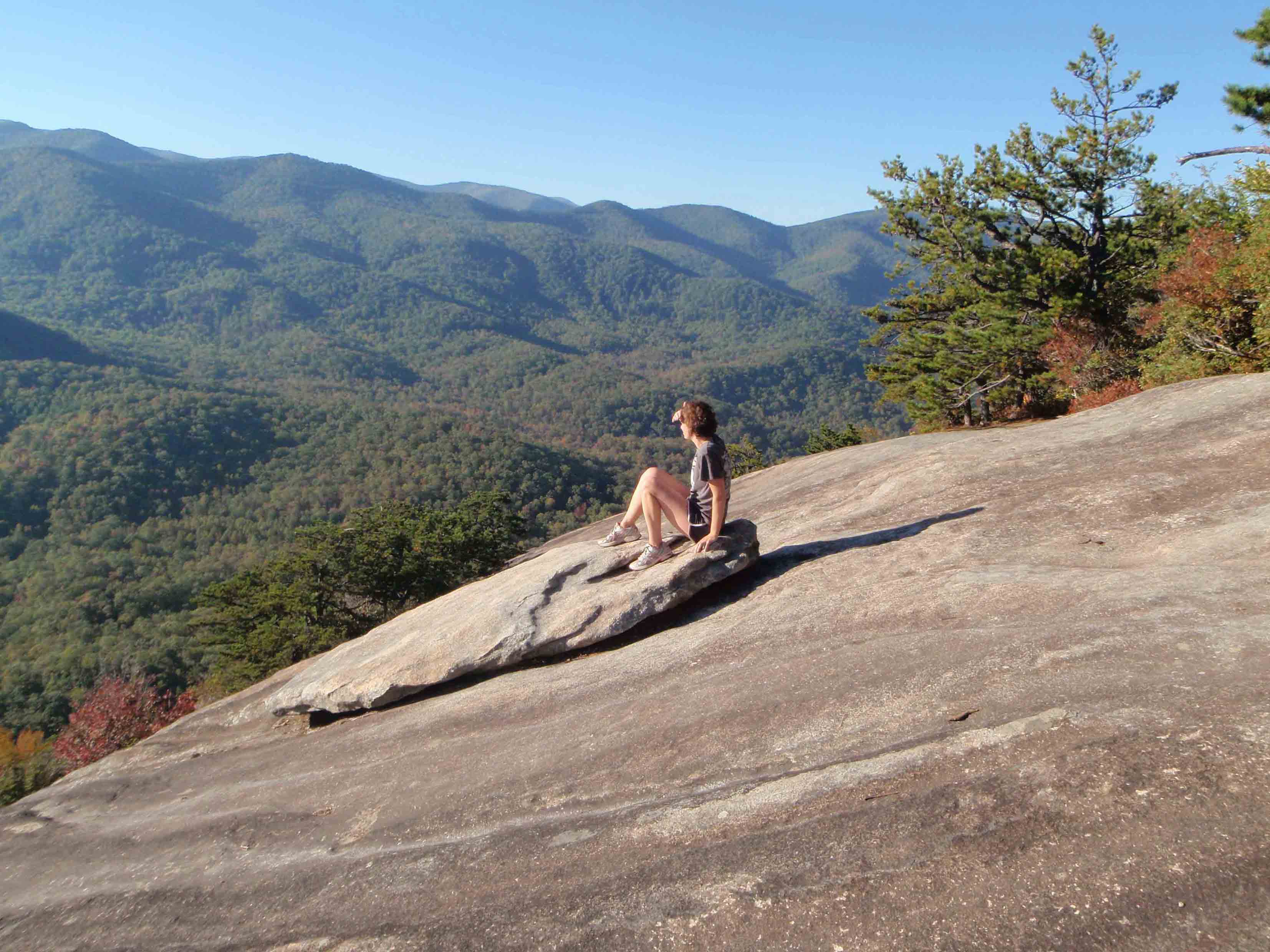
HIGHLIGHTS: Beautiful views of Pisgah Ridge from the top of Looking Glass Rock
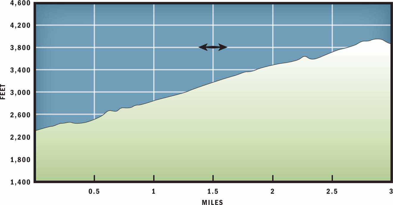
ELEVATION: 2,303 feet at the trailhead to 3,960 feet just above Looking Glass Rock
ACCESS: Free and always open
MAPS: USGS Shining Rock
FACILITIES: None
COMMENTS: From the top of Looking Glass Rock, be aware that there is a steep drop near the edge of the rock. Stay near the path and trees to enjoy the view.
CONTACTS: (828) 257-4200; fs.us.gov/nfsnc


Overview
Looking Glass Rock is one of the most recognized natural features in Western North Carolina. For many motorists who travel the Blue Ridge Parkway, viewing the giant monolith is one of the highlights of their trip. However, to actually hike to the top of the granite rock face, you will have to take a narrow trail up multiple switchbacks to reach Looking Glass ridge. There you will enjoy some relatively level hiking before the trail offers a brief descent that places you directly on top of Looking Glass Rock. From this overlook, you will enjoy fantastic north-facing views.
Route Details
About 400 million years ago, continental plates beneath the earth’s surface collided, causing tension and heat to melt sedimentary rock into magma. That magma solidified into Whiteside granite, and today Looking Glass Rock provides stunning views of the eroded rock. Geologically classified as a pluton monolith, Looking Glass Mountain gained its name from the bright reflection of sunlight off its exposed granite.
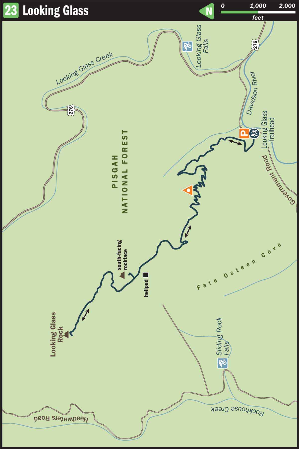
Rising over 1,700 feet from the valley floor, Looking Glass Rock is a popular destination for both hikers and mountain climbers. To get to the top of the steep granite slope, start at the Looking Glass parking area and trailhead off FR 475 and hike west from the only trailhead in the parking area. Within a few dozen feet you will arrive at a wooden kiosk. Stop to see if there is any pertinent information posted on the information board, then continue to veer left onto a well-defined singletrack trail and begin your ascent.
Early on, the climb is moderate and contours the hillside above a small stream. However, after hiking 0.4 miles you will begin a long stretch of switchbacks that slowly weave their way up the mountain. The twisting, turning trail winds through a hardwood forest of tulip poplars, Fraser magnolia, hickory, sourwood, and beech trees.
After hiking a little over a mile uphill, you will arrive at a small rock outcropping. By taking a few steps off the path to explore this overlook you will be able to view the mountains and ridges to the east and north. During the winter months it is possible to identify Bearpen Mountain and Coontree Mountain from this spot. There is also a twisted root formation sprawling out across the granite overlook that is almost as rewarding to study as the view.
At mile 1.4 you will enter a dense rhododendron patch. When you exit the long green tunnel you will be greeted with a more level grade and an end to the switchbacks. Although you are no longer weaving your way up the side of the mountain, you still gradually gain elevation on your way to Looking Glass Ridge. At mile 2 you will notice an exposed area of level granite bordering the trail. This serves as a helipad to rescue injured hikers or climbers in the area.
A few hundred yards past the helipad you will notice a slanted rock wall on your right. If you take the time to climb to the top of this steep exposed granite you will be rewarded with terrific southern views that are not available from Looking Glass Rock. The vista even provides glimpses of two neighboring pluton monoliths: John Rock and Cedar Rock Mountain.
After leaving this viewpoint, continue along the ridge amid the copious galax that lines the trail. At 2.7 miles you will reach a campsite on top of Looking Glass Mountain, but in order to access the incredible views from the top of the exposed rock face, you will need to travel another 0.1 mile slightly downhill to where the forest opens up on top of the giant monolith.
On a clear day, the view from on top of Looking Glass Rock reveals Pisgah Ridge and the Blue Ridge Parkway to the north. This is also a popular spot for ravens to soar directly above the rock, and seasonally you might also notice a threatened peregrine falcon coming to roost in the rocky ledges. An even stranger site might be watching a person or two appear over the edge of the vertical north slope of the mountain.
It may seem implausible for someone to access the summit from the north side of the mountain, but this is a favorite destination for many skilled mountain climbers. The sheer rock face of the Looking Glass provides several different climbing routes to the summit. You may be tempted to walk closer to the edge and watch these individuals climb up the mountain or look for a peregrine falcon nest below, but remember that you are not attached to a rope or a harness, so do not travel too far from the edge of the forest.
When you are ready to say good-bye to the beautiful views from the top of Looking Glass Rock, retrace your steps slightly uphill for a few hundred yards to the mountaintop campsite and then enjoy an entirely downhill trip back to the parking area.
Nearby Attractions
If you head southeast from the trailhead, the Pisgah Wildlife Education Center and Fish Hatchery is 1 mile farther down FR 475 on the right. The center includes a gift shop, museum, and half-hourly informational video showings. The center is open Monday–Saturday, 8 a.m.–4:45 p.m.; closed for most state holidays.
Directions
From Asheville, take I-26 to Exit 40, the Asheville Airport and Brevard Road/NC 280 exit. Turn right off the exit and follow NC 280 for 17 miles to the outskirts of Brevard. At the US 64/US 276 intersection, turn right and enter Pisgah National Forest. Continue on US 276 for 5.5 miles and then turn left onto FR 475. Drive 0.4 miles and then turn into the Looking Glass parking lot on the right.