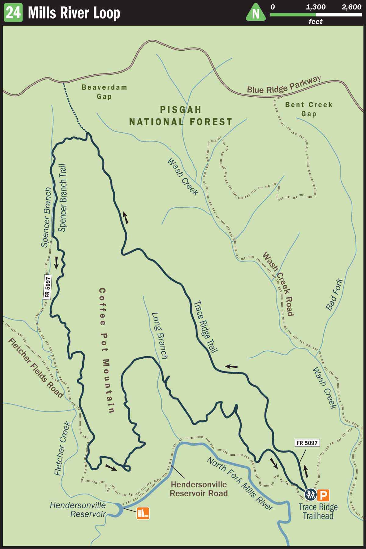
24 Mills River Loop
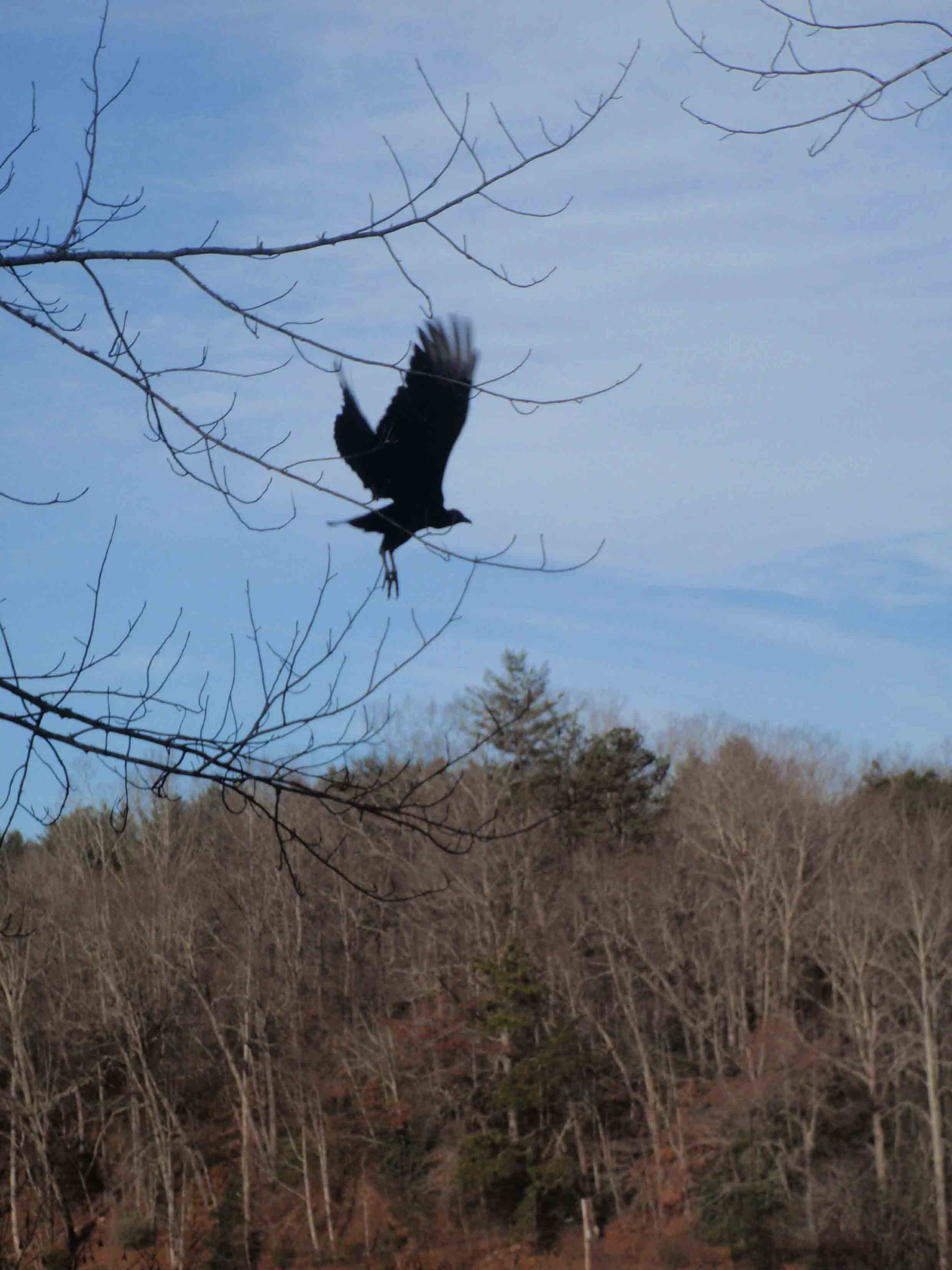
WILDLIFE IS COPIOUS IN THE MILLS RIVER RECREATION AREA.
SCENERY: 
TRAIL CONDITION:
CHILDREN: 
DIFFICULTY:
SOLITUDE:
GPS TRAILHEAD COORDINATES: N35° 25.213' W82° 39.410'
DISTANCE & CONFIGURATION: 8.1-mile loop
HIKING TIME: 4 hours
HIGHLIGHTS: A gentle gradient and scenic forest service road
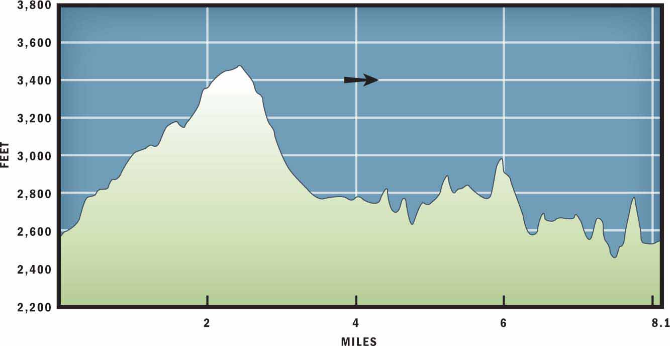
ELEVATION: 2,439 feet near the trailhead to 3,481feet on Trace Ridge
ACCESS: Free and always open
MAPS: USGS Dunsmore Mountain
FACILITIES: Toilets at North Mills River Recreation Area
WHEELCHAIR ACCESS: None
COMMENTS: The most confusing portion of this hike is getting to the trailhead. Make sure you travel 2.4 miles on the forest service road, past a pit toilet and trailhead on your right, to where the road dead-ends at locked forest service gates.
CONTACTS: Pisgah National Forest (828) 257-4200; cs.unca.edu/nfsnc
Overview
If you are looking to stretch your legs on a long hike, but at the same time are worried about Western North Carolina’s challenging terrain, then this is a great loop to build up your confidence and mileage. You will begin the hike gradually on a singletrack trail along Trace Ridge Trail. Just before reaching the Blue Ridge Parkway, the route descends southeast to meet with Spencer Branch. Past Spencer Branch you will turn left on a forest service road and follow the wide dirt path east. The forest service road travels between towering pine and poplar trees and provides an easy stretch of hiking back to the parking lot and trailhead.
Route Details
The Mills River Loop starts at the Trace Ridge Trailhead in the North Mills River Recreation Area. This portion of Pisgah National Forest offers a wealth of connecting trails and, for the ambitious hiker, a longer day hike could lead all the way to Bent Creek—which would add substantial mileage to this route and need to be completed as a shuttle hike as opposed to a loop. This 8.2-mile loop, however, stays near the North Fork of the Mills River on the south side of Pisgah Ridge.
The route offers a satisfying day hike with gradual grades. The hike is especially inviting in winter, when bare trees reveal views of neighboring mountains and ridgelines.
To begin the hike, locate the gated Forest Service Road 5097. The gate, to the west of the parking area, marks the beginning and end of the trek. Once you arrive at the gate, do not walk past it, but look to your right and locate a singletrack trail. This is Trace Ridge Trail. Turn right on the orange-blazed path and follow it uphill into the forest.
After 0.2 miles the singletrack intersects FR 5097A. Follow the combined route 100 yards and then veer left (west) to continue on Trace Ridge Trail. Follow Trace Ridge Trail back into the forest under a canopy of oak, poplar, and hickory trees. As you continue to make your way uphill, the tall hardwood trees give way to a tunnel of green mountain laurel and rhododendrons. And although you continue to gain elevation, the gentle slope makes the hiking pleasant and the climb goes almost unnoticed.
At mile 1.8 the trail grade increases, and you will remember that you are, in fact, hiking uphill. For 0.25 miles the trail presents a challenging but manageable ascent and then levels out on the spine of Trace Ridge. At this point you may be able to see or hear the Blue Ridge Parkway to the north. It is hard to imagine that you are so close to the national scenic road, because the driving distance between the Blue Ridge Parkway and North Mills River Recreation Area is fairly substantial. However, as the crow flies you are now less than a mile from the popular motor route.
At mile 2.7 you will notice some loose footing on the treadway, followed by a brief dip in the ridgeline. After traveling the short downhill portion of trail, you will arrive at the Spencer Branch junction. At this point, or at another time, if you wanted to hike to the Blue Ridge Parkway you could continue straight on the Trace Ridge Trail. However, to continue on this Mills River Loop, you will want to turn left and hike downhill on Spencer Branch Trail.
Your path down Spencer Branch Trail is steep and slightly eroded. At 3.1 miles you will come to Spencer Creek. Rhododendron, dog-hobble, and ferns border this small creek. There are a handful of backcountry campsites and fallen logs near the stream that provide a nice resting place to stop and enjoy a snack. The route follows the quaint water source another 0.3 miles to where it crosses under FR 5097. From there the creek will continue down the drainage basin to connect with the North Fork on the Mills River. You, however, will turn east on the forest service road and contour the slopes of Coffee Pot Mountain.
The winding dirt road provides a scenic route through the tall maple, pine, and Fraser magnolia trees. If you walk quietly, this is an excellent place to spot a deer, wild turkey, or black bear on the slopes below the road. However, because the forest service road provides such nice walking and easy access into the depths of the North Mills River Recreation Area, you are also likely to spot a handful of individuals dressed in camouflage. Be sure to wear bright colors if you venture out during hunting season!
At mile 5.9 you will cross over Long Branch Creek, which lines the cove between Coffee Pot Mountain and Trace Ridge. From there you will travel southwest along the mountain slope to the gate at the end of FR 5097, directly to the west of the Trace Ridge Trailhead and your parked car.
Nearby Attractions
North Mills River Recreation Area offers full-service camping, backcountry campsites, a picnic area, and many opportunities for fly-fishing if you have a current North Carolina fishing license.
Directions
Travel I-26 south from Asheville to Exit 40. Turn right off the exit onto NC 280. Travel 4.5 miles and then turn right on County Road 1338/South Mills River Road. After 3.1 miles turn right on County Road 1341/Whitaker Lane and drive an additional 1.1 miles to reach County Road 1345/North Mills River Road. Turn left on North Mills River Road and travel 1.6 miles. Just before reaching the North Mills River Recreation Area Campground, turn right on FR 5000. After 0.3 miles the paved road will give way to packed dirt. At 0.9 miles the road goes around a hairpin turn and continues on to reach a trailhead and road intersection at mile 1.9. Veer left at the intersection and travel across a bridge. Continue uphill for 0.5 miles to reach Trace Ridge Trailhead.