27 Cold Mountain

GREAT VIEWS ABOVE THE RHODODENDRON TREES ON TOP OF COLD MOUNTAIN
SCENERY: 
TRAIL CONDITION: 
CHILDREN: 
DIFFICULTY: 
SOLITUDE: 
GPS TRAILHEAD COORDINATES: N35° 23.214' W82° 53.775'
DISTANCE & CONFIGURATION: 10-mile out-and-back
HIKING TIME: 7.5 hours
HIGHLIGHTS: A beautiful wooded walk to the summit of a famous literary peak, Cold Mountain
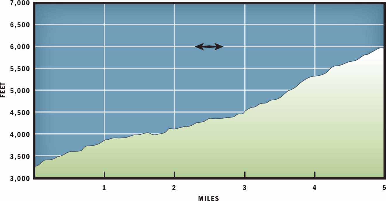
ELEVATION: 3,260 feet at trailhead to 6,005 feet on top of Cold Mountain
ACCESS: Free and always open
MAPS: USGS Cruso
FACILITIES: None
WHEELCHAIR ACCESS: None
COMMENTS: Allow a full day to reach the summit of Cold Mountain. The trailhead is just over a 1-hour drive from Asheville, so 10 hours should be allotted for this hike door-to-door.
CONTACTS: (828) 257-4200; fs.us.gov/nfsnc


Overview
When Charles Frazier’s Civil War novel, Cold Mountain, came out in 1997 and subsequently sold more than 3,000,000 copies, the wooded 6,000-foot mountain that casts its shadow just northwest of Asheville became known around the world. The out-and-back hike to the top of Cold Mountain starts just south of Camp Daniel Boone and climbs steadily uphill for 5 miles to the summit. There are sparse but spectacular views from the summit and a beautiful mixed hardwood forest leading to the peak.
Route Details
National Book award winner Charles Frazier was born in Asheville, North Carolina, and grew up in the Andrews and Franklin area of Western North Carolina. His first book, Cold Mountain, brought immediate attention to the spectacular mountain that dominates the landscape south of Canton. In his book, Frazier explores themes of man’s relationship with nature, isolation, and self-discovery. If you decide to attempt the challenging 10-mile round-trip to the summit of Cold Mountain, then you will most likely relate to those same topics on your hike.
The trailhead for Cold Mountain is located on the south edge of Camp Daniel Boone, and the roads leading to the trailhead are circuitous and frequently change names. You should bring a street map to clarify the directions included in this guidebook. There is a useful hand-drawn map that you can print out for free on the Camp Daniel Boone website: campdanielboone.org.
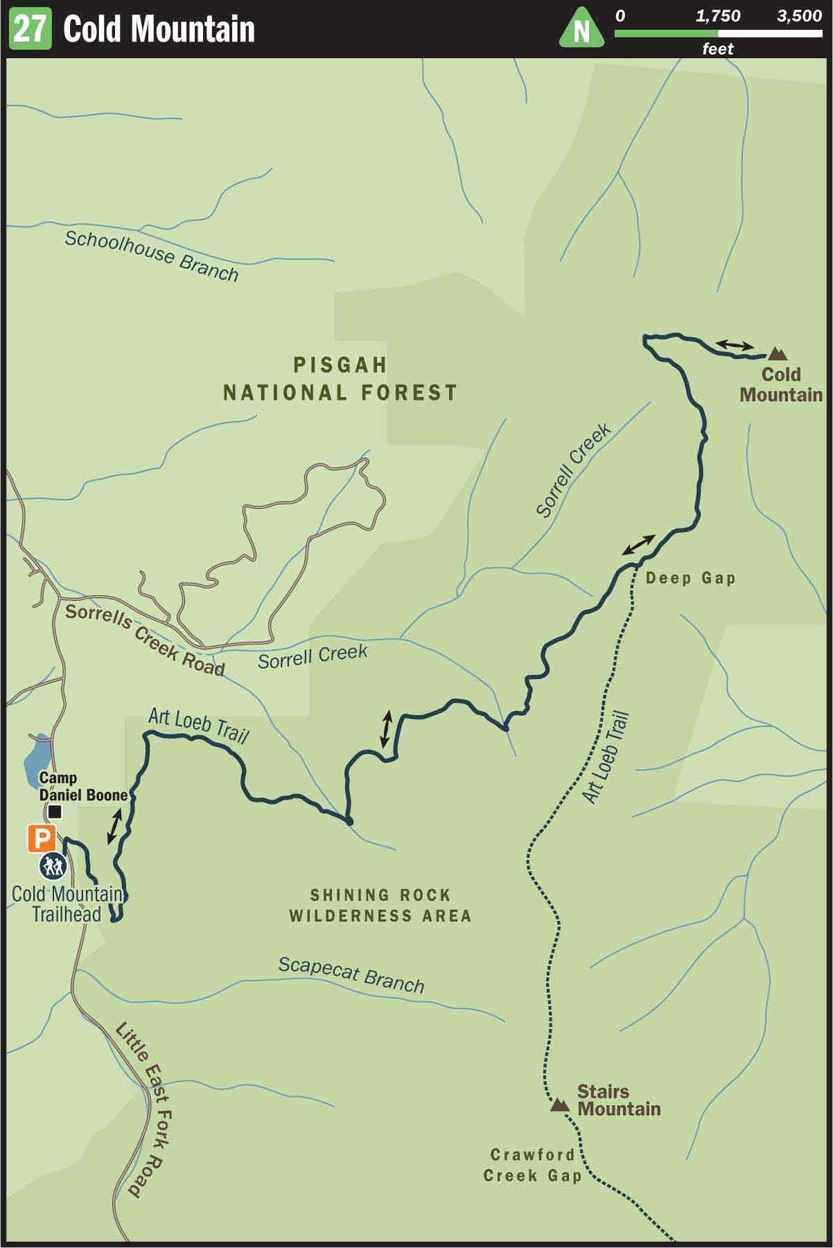
The Cold Mountain Trailhead also serves as the northern terminus of the Art Loeb Trail. To begin your hike, follow the Art Loeb Trail east and uphill. Thankfully, unlike most of the confusing trails and unmarked intersections in the Shining Rock Wilderness, the hike to the top of Cold Mountain is a generally straightforward, easy path to follow. The only trail junction will come once you reach the ridge.
If you are expecting spectacular mountain views leading up to Cold Mountain, then you will be disappointed. The first 3.5 miles of hiking lie entirely within the woods. That said, the dark and dense hardwood forest that lines the path is intimately beautiful and provides a sense of isolation and wilderness. The woods on the back side of Cold Mountain are very quiet, and you rarely will hear even a distant car or a plane flying overhead.
The first 1 mile of walking follows a steady uphill grade that will get your blood pumping and cause you to take off that extra top layer of clothing. After the first mile, the climb becomes more moderate and rocks litter the trail. Although this trail up Cold Mountain is indeed challenging and continues almost entirely uphill, the ascent is not as steep or difficult as trails, such as Old Butt Knob, that ascend the opposite slope. The Art Loeb Trail does a nice job of contouring the mountain and gaining elevation gradually.
At 1.8 miles you will cross a clear mountain brook. And after 3 miles the hike will increase in difficulty as you make a final 0.5-mile uphill push to reach Deep Gap. At Deep Gap there is a small grassy opening. You may want to take a quick rest there and eat a snack before climbing the remaining 1.5 miles to the summit. When you are ready to leave Deep Gap, you will notice that several trails depart the grassy field. The Art Loeb Trail exits to the south, and several spur trails lead off the ridge to nearby camping spots. From the middle of the gap, make a 90-degree left-hand turn and hike north on the spine of the ridge to follow the Cold Mountain Trail.
The ascent up Cold Mountain is much like the rest of the hike—densely wooded and uphill. At 4.4 miles you will pass a piped spring that is a mere trickle during dry periods. Continuing past the water source, you will begin to pass several backcountry campsites. Some of these sites on the north side of the ridge offer views of the farmland below. Furthermore, when the paper mill in Canton is operating, you can expect to see a large plume of white smoke in the distance.
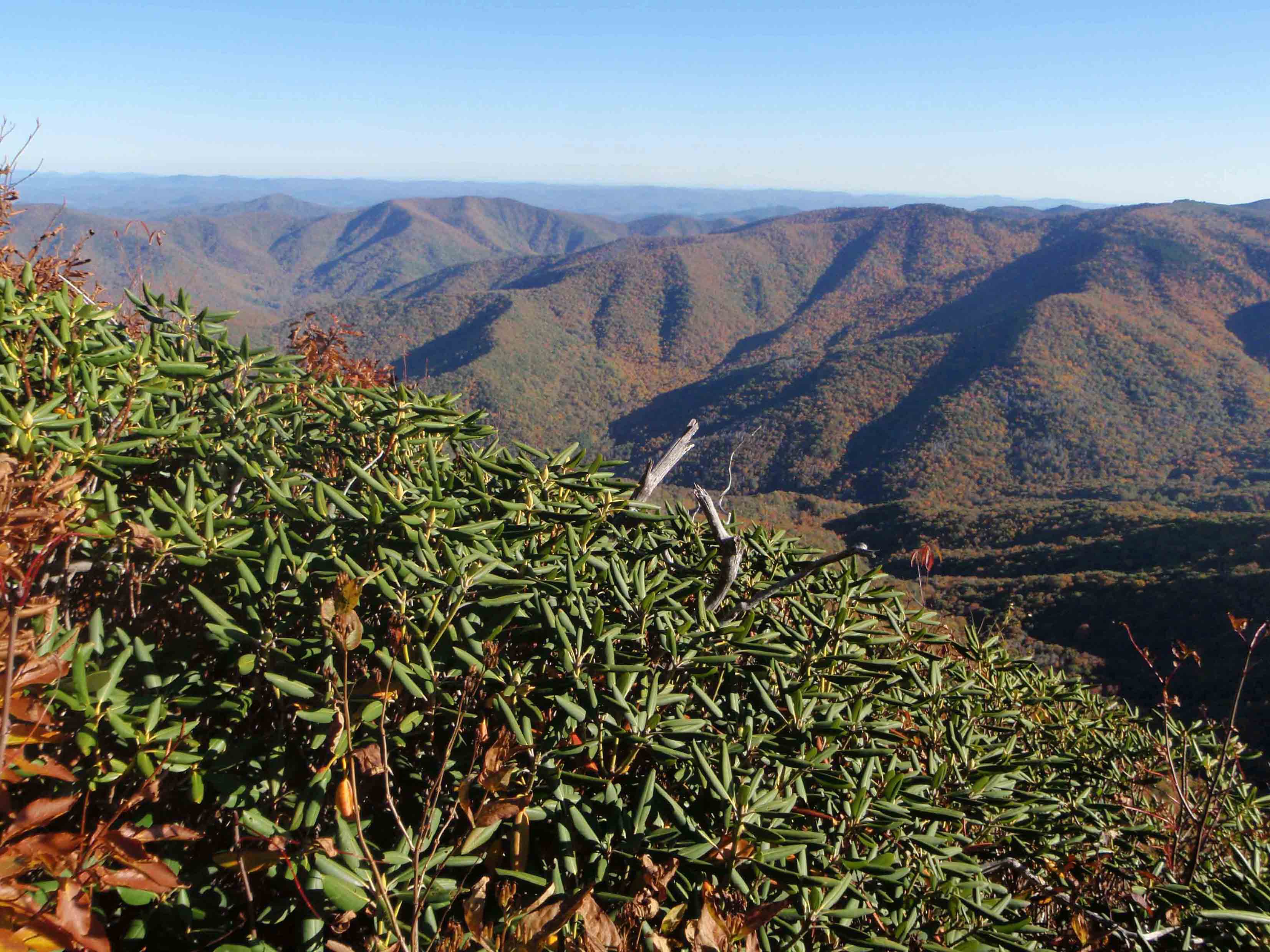
The final 0.1 mile of walking will reveal your best views of the hike: several rock outcroppings near the summit provide gorgeous southern views of the Great Balsam Mountains. At 5 miles you will know you have arrived at the true summit of Cold Mountain when you spy the geological survey marker anchored in the rocks.
Congratulations! You are now above 6,000 feet on a summit that is world famous in modern literature. And now you have a gradual 5-mile descent to enjoy as you savor your accomplishment. As you head down, you no doubt will wonder why—with such natural beauty all around you—was the 2003 film Cold Mountain, starring Jude Law, Nicole Kidman, and Renee Zellweger, filmed in Romania and not in the true shadows of Cold Mountain?
Nearby Attractions
Camp Daniel Boone borders the Cold Mountain Trailhead. Enjoy viewing the scenic camp as you drive through the main campus, but remember to drive slowly. The camp is private property, so you should not stop in uninvited.
Directions
From Asheville, follow US 19/23 south approximately 12 miles. Turn left onto Sorrells Street/NC 110. In 0.5 miles turn right onto Pisgah Drive and continue on NC 110. After driving 5 miles on Pisgah Drive/NC 110 the road becomes Love Joy Road/NC 215. Continue 2.9 miles on NC 215 and then turn left onto Lake Logan Road/NC 215. In 2.3 miles turn left onto Little East Fork Road. Drive 4 miles on Little East Fork Road to reach Camp Daniel Boone. Drive slowly through the camp to locate the trailhead at the camp’s southern boundary. There is designated parking on the right side of the road. (And don’t forget to bring along the Internet-accessible map noted in “Route Details,” above.)