Previous Chapter | Next Chapter | Table of Contents
Chena Hot Springs | Where to Stay in Chena Hot Springs | Central and Circle | Steese and White Mountains | Yukon–Charley Rivers National Preserve | Manley Hot Springs | The Dalton Highway
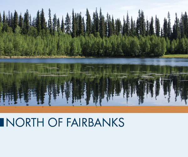
When you drive north of Fairbanks you enter territory where people are few and far between. Away from the thin line of the highways spread hundreds of thousands of square miles with few signs of human habitation. Accordingly, driving in the north country involves both nail-biting and jaw-dropping experiences. You might pick up hitchhikers carrying a moose and the smell of having camped for a month. You might see the swirl of musk oxen running from the noise of your car. And you might—probably will—set a personal record for how many cracks your windshield gets in a single day.
On the roads heading east, northeast, and northwest of Fairbanks, the going gets tougher the farther you drive. However, the gravel and other assorted surfaces are worth the trouble of navigating; these roads open up long slivers of the Alaskan wilderness. And since Alaska is so big, the more country you cover, the better your understanding of the place—and the better your chances of understanding the history of each unique road from the stories shared by the people you meet. TIP Road conditions can be rough, and if you break down, help may be a long way off, so be sure to check your fuel and spare tire before you go. And if you’re driving your own car, windshield replacement insurance is the smartest money you’ll spend on the trip. You will be making a claim. No question.
Camping off Chena Hot Springs Road
The best rooms with views anywhere north of Fairbanks are in good campgrounds with a good, four-season tent. Don’t forget the DEET, never, ever take food into your tent (do you really want your shelter to smell like a candy wrapper to bears?) and be prepared to spend the night in the real Alaska, under the stars, listening to the wolves howl.
Red Squirrel Campground. If you want to combine easy fishing access with your camping, the grassy Red Squirrel State Campground at Mile Marker 42.8 is your top choice: it’s got a pond stocked with grayling. | Mile 42.8, Chena Hot Springs Rd.
Rosehip Campground. At Mile 27 you’ll find these campgrounds; they’re very basic but have the essentials for family camping. There’s a trail that leads down to the river, which makes it a good put-in and take-out spot for paddlers. | Mile 27, Chena Hot Springs Rd.
Tors Trail Campground. Campers at Mile 39.5 are adjacent to the Granite Tors trailhead, a 15-mile loop into the high country. Also across from the campground you’ll find a parking area (free for campers) and picnic spot near the river. There are no flush toilets here. | Mile 39.5, Chena Hot Springs Rd.
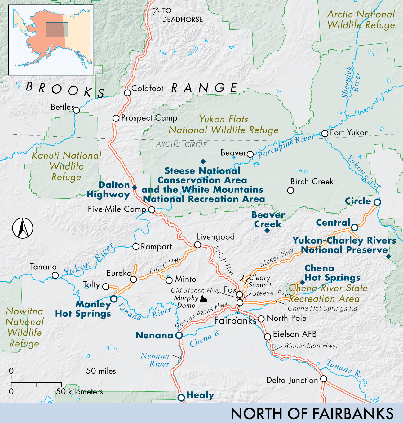
Follow the Chena Hot Springs Road to its end and you’ll find a natural hot spring that is among the best in the state. The Steese Highway connects to historic goldfields in Central and Circle, while the Elliott Highway leads northwest and, before shifting to the southwest, connects to the roughly north–south Dalton Highway (built to assist construction of the Trans-Alaska Pipeline System). All three roads provide access to countless starting points for hiking, skiing, camping, fishing, canoeing, and other outdoor-oriented adventures.
Chena Hot Springs
62 miles northeast of Fairbanks.
Exploring Chena Hot Springs
Chena Hot Springs.
The 57-mile paved Chena Hot Springs Road, which starts 5 miles outside Fairbanks, leads to Chena Hot Springs, a favorite playground of many Fairbanks residents. The road passes several attractions, including Chena River State Recreation Area and Chena Hot Springs Resort. If you’re heading to the resort, don’t skip the hiking, fishing, camping, and canoeing along the way. TIP
The chances of spotting a moose are excellent if you keep a sharp eye on the roadside.
From Mile 26 to Mile 51 the road passes through the Chena River State Recreation Area, a diverse wilderness of nearly 400 square miles. You can also stop for a picnic, take a hike for an hour or an extended backpacking trip, fish for the beautiful yet gullible arctic grayling, or rent a rustic backcountry cabin to savor a truly wild Alaskan adventure. Grayling fishing in the Chena River is catch-and-release, single-hook, artificial lure only. There are several stocked lakes along the road affording catch-and-keep fishing for rainbow trout, which are well suited for the frying pan.
Outdoor Activities and Guided Tours
Dogsledding
Chena Dog Sled Adventures.
Chena Dog Sled Adventures provides winter visitors a chance to drive a dog team or ride in a sled. Ice fishing and snowshoeing are also available. Call ahead for reservations, directions, and accommodations. | Box 16037 | Two Rivers | 99716 | 907/488–5845 | www.ptialaska.net/~sleddogs.
Hiking
Granite Tors Trail.
The Granite Tors Trail, a 15-mile loop, can be done in a day, and offers a view of the upper Chena Valley and an opportunity to see dramatic “tors” (fingers of rock protruding through grassy meadow) that are reminiscent of the moai monuments of Easter Island. The trail is steep, but the views at the top make the climb worthwhile. Although the Interior landscapes lack the
impressive mountain views of other parts of the state, the enormous expanse of rolling hills and seemingly endless tracts of forest are every bit as awe-inspiring. However, since there are no mountains here to collect snow and contribute to the water table, water sources along the way are unreliable. TIP
Bring a couple of quarts of water per person, plus mosquito repellent. Hiking uphill on a hot summer day is dehydrating. Also, weather is fickle here, and a bright, sunny morning can easily turn into an overcast, rainy, and windy afternoon. Come with adequate clothing, including rain gear, no matter how promising the skies look in the morning. A shorter hike is the 3.5-mile Angel Rocks Trail, near the eastern boundary of the area.
Paddling
Chena River State Recreation Area.
The Chena River State Recreation Area has numerous well-marked river-access points (the Chena Hot Springs Road parallels the Chena River, and canoeists use several put-in points along the way). The lower sections of the river area are placid, but the area above the third bridge, at Mile 44.1, can be hazardous for inexperienced boaters.
Renewable Energy at Chena Hot Springs Resort
Don’t feel guilty about leaving on the lights at Chena Hot Springs Resort; most of the energy is geothermal. Since July 2006 the resort has been utilizing the 165°F springwater to power three turbines. This feat shocked geothermal experts who claimed that water temperatures must be at least 220°F. This free source of power allows the resort to run greenhouses through the –40°F winters. The daily 2 pm free Renewable Energy tours end at these productive greenhouses, where row upon row of lettuce, up to 25 heads a day, and five varieties of tomatoes thrive off a hydroponic, or soil-free, system. Order a salad for dinner and taste the special flavor of local, fresh-picked greens.
Alaska Wilderness Enterprises.
Wilderness Enterprises has guided fishing for arctic grayling and scenic float trips on the Chena River. Half-day and full-day trips are available. When the temperatures drop, try your hand at ice fishing. Prices start around $175/day. | 907/488–7517 | www.wildernessenterprises.com.
Where to Eat in Chena Hot Springs
Two Rivers Lodge.
$$$ | SEAFOOD | Fairbanksans are known to make the 40-mile round-trip for the delicious dinners here, including prime rib, frequent crab specials, and other Alaskan seafood dishes. Don’t be discouraged by the building’s outward appearance—rustic logs belie the menu’s elegance. For a study in Alaskan-style contrasts, stop in the Trapline Lounge first for a predinner refreshment. |
Average main: $25 | Mile 16, Chena Hot Springs Rd. | 99712 | 907/488–6815 | www.tworiverslodge.com | No lunch.
Where to Stay in Chena Hot Springs
Fodor’s Choice | Chena Hot Springs Resort.
$$$ | RESORT | People come in droves to soak in the hot springs—in the hot tubs, the indoor family swimming pool, or the outdoor natural-rock lake (ages 18-plus). Just as many, if not more, flock to see the magnificent aurora that so often lights up in the skies above the resort. Miles from the nearest town, in winter you
can snowmobile, dogsled, and take a 4½-mile snow-coach tour to a hilltop yurt with a 360-degree panorama. Summer activities include therapeutic massages, sled-dog cart rides, horseback riding, ice-sculpting classes, and guided ATV tours. Don’t miss the world’s only year-round Aurora Ice Museum complete with an ice bar, ice bedrooms, and a multitude of ice carvings created by world-class carvers. Tours of the Ice Museum are $15. There are also sports-equipment rentals, camping
sites, and yurts ($65 and up) for rent. Pros: it’s 95% powered by geothermal energy; there’s an activity for every taste. Cons: Wi-Fi comes with a daily usage fee at the Aurora Cafe; there are only eight TV channels. TripAdvisor: “rustic location,” “just super,” “lots of stuff to do.” | Rooms from: $189 | Mile 56.5, Chena Hot Springs
Rd. | 99712 | 907/451–8104 | www.chenahotsprings.com | 80 rooms.
Department of Natural Resources Cabins.
$ | RENTAL | Used by adventurers with extensive backcountry experience, these cabins have woodstoves, bunks, and tools for cutting wood. You have to supply everything else—food, bedding, water, cooking utensils. This is basic Alaskan shelter, but it can’t be beat for leaving the real world behind. Hiking distances range from 3 to 10 miles, but the North Fork
and Chena River cabins are road-accessible. The nightly fee ranges from $25 for the Colorado and Angel Creek cabins to $50 per night for the larger North Fork and Chena River cabins. Wildlife in the area includes moose, porcupines, lynx, fox, pine marten, wolves, coyotes, black bears, and, occasionally, grizzly bears. Facilities vary with each cabin. Pros: wilderness is at your doorstep. Cons: only amenities are
the ones you bring along. | Rooms from: $25 | Mile 32 to 50, Chena Hot Springs Rd., Chena River State Recreation Area | 99712 | 907/451–2705 | www.dnr.alaska.gov | Reservations essential | 5 cabins.
Central and Circle
From Fairbanks: 128 miles northeast on the Steese Hwy. to Central, 162 miles on Steese to Circle.
Steese Highway.
The Steese Highway follows the Chatanika River and several other creeks along the southern part of the White Mountains. It eventually climbs into weatherworn alpine mountains, peaking at Eagle Summit (3,624 feet), about 100 miles from Fairbanks, and drops back down into forested creek beds en route to Central. At Central you can drive the 30-plus miles on a winding gravel road to Circle, a small town on the
Yukon River. The highway is paved to Mile 44 and usually in good shape. A possible exception is in winter, when Eagle Summit is sometimes closed due to drifting snow.
Outdoor Activities and Guided Tours
Tour companies are scarce in the area. Outdoor activities are generally do-it-yourself.
Paddling
Chatanika River.
The Chatanika River, a choice spot for canoeists and kayakers, is still fairly close to Fairbanks. The most northerly access point is at Cripple Creek campground, near Mile 60, Steese Highway. Other commonly used access points are at Long Creek (Mile 45, Steese Highway); at the state campground, where the Chatanika River crosses the Steese Highway at Mile 39; and at the state’s
Whitefish Campground, where the river crosses the Elliott Highway at Mile 11. The stream flows into the Minto Flats below this point, and river access is more difficult.
Camping in Steese and White Mountains
You can camp pretty much anywhere on public land, but you might as well do it where somebody else has prepared the spot. The BLM campgrounds are cheap, clean, and usually pretty empty.
BLM Campgrounds. The BLM (Bureau of Land Management) manages three road-accessible campgrounds in the Steese Highway area: one at Mile 60 and two off Mile 57 (up 7 miles on the U.S. Creek Road with one at each end of the Nome Creek Road junction). The Cripple Creek Campground at Mile 60, Steese Highway, is the best for RVs, with a dozen sites and a half-dozen places for tents. On the Dalton Highway there are two sites: one undeveloped site at Mile 115 near the Arctic Circle and one at Mile 180, 5 miles north of Coldfoot. The campgrounds are available on a first-come, first-served basis. In addition, you’ll find several undeveloped campsites along the Dalton—old gravel pits with no facilities, available free of charge (though they might not be every visitor’s first choice). These are really great sites for campfires—and you’ll want them, given the particular voraciousness of mosquitoes in and around these parks. TIP Check the Web site for the most up-to-date information. | 907/474–2251 or 800/437–7021 | www.blm.gov/ak.
Water in the Chatanika River may or may not be clear, depending on mining activities along its upper tributaries. In times of very low water, the upper Chatanika River is shallow and difficult to navigate. TIP Avoid the river in times of high water, especially after heavy rains, because of the danger of sweepers, floating debris, and hidden gravel bars.
Alaska Public Lands Information Center. Contact the Alaska Public Lands Information Center for the status of the river. | 907/459–3730.
Where to Stay in Central and Circle
Chatanika Lodge.
$$ | B&B/INN | Rocket scientists from the nearby Poker Flat Research Range gather at this cedar lodge, as do mushers (staff can arrange dogsled rides), snowmachiners, and local families. The eclecticism of the clientele is matched by the diamond willow lamps and a variety of wild-animal trophy heads and skins, including bear, lynx, and wolf. Most of the 30,000 Christmas lights
at the lodge stay up year-round. The rooms generally have a double and single bed, sink, and TV. The toilets and showers are down the hall. Pros: a local favorite; Alaskan character. Cons: long drive from Fairbanks; shared bathrooms. TripAdvisor: “another fun stop,” “one of the best lodges in Alaska,” “worth the scenic drive.” | Rooms from: $80 | Mile 28.5,5760 Steese Hwy. | 99712 | 907/389–2164 | www.chatanikalodgealaska.com | 10 rooms with shared bath.
Steese and White Mountains
30 miles north of Fairbanks via Elliott Hwy.
The Steese and White Mountains are readily accessible, just a quick jaunt up the Elliott Highway. But once you’re here, you’ll have a few hundred thousand acres pretty much to yourself, with opportunities for everything from a short hike to a monthlong expedition.
Exploring Steese and White Mountains
Beaver Creek.
Rising out of the White Mountains National Recreation Area, Beaver Creek makes its easy way north. If you have enough time, it’s possible to run its entire length to the Yukon, totaling 360 river miles if done from road to road. If you make a shorter run, you will have to arrange a take-out via small plane. A lot of people make the trip in five or six days, starting from Nome Creek and taking out at Victoria
Creek. Contact Alaska Outdoor Rentals and Guides to schedule a trip. Don’t try this on your own unless you’re an expert in a canoe.
Birch Creek.
In the Steese National Conservation Area you can take a four- to five-day or 126-mile float trip on the lively, clear-water Birch Creek, a challenge with its several rapids; Mile 94 of the Steese Highway is the access point. Along the way you should see plenty of moose, caribou, and dozens of species of birds. This stream winds its way north through the historic mining country of the Circle District. The first
take-out point is the Steese Highway Bridge, 25 miles from Circle. Most people exit here to avoid the increasingly winding river and low water. From there Birch Creek meanders on to the Yukon River well below the town. Fairbanks outfitter Alaska Outdoor Rentals and Guides arranges these trips.
Steese National Conservation Area and the White Mountains National Recreation Area.
For those who want to immerse themselves in nature for several days at a time, the Steese National Conservation Area and the White Mountains National Recreation Area have opportunities for backcountry hiking and paddling. Both areas have road-accessible entry points, but you cannot drive into the Steese Conservation Area. The White Mountains
Recreation Area has limited camping facilities from June to November; reservations are not accepted. | 907/474–2200
Bureau of Land Management [BLM].
Where to Stay in Steese and White Mountains
Public-Use Cabins.
$ | RENTAL | The Bureau of Land Management runs 11 public-use cabins in the White Mountains National Recreation Area and one road-accessible cabin on the Elliot Highway, with 300 miles of interconnecting trails. Designed primarily for winter use by dog mushers, snowmachiners (snowmobilers), and cross-country skiers, cabins provide shelter for summer backpackers, although summer
access is limited by mountainous and boggy terrain. The cabins have bunk beds, woodstoves, tables, and chairs. Permits are required and available up to 30 days in advance. Pros: remote locations allow for an intimate experience with the land. Cons: permits required; geared for winter use; no place to take a hot bath. | Rooms from: $25 | Fairbanks District Office
of BLM,1150 University Ave. | Fairbanks | 99709 | 907/474–2251, 800/437–7021 | www.blm.gov/ak | 12 cabins.
Yukon–Charley Rivers National Preserve
20 miles north of Eagle, 100 miles east of Fairbanks.
Getting Here and Around
If you’ve driven out to Eagle, you might as well go beyond: Yukon–Charley Rivers is one of the most untouched, unspoiled, unvisited parts of Alaska. Hire a charter to get you onto the river, or just drop the canoe in the water and start paddling.
Exploring Yukon–Charley Rivers National Preserve
Yukon–Charley Rivers National Preserve.
The 126-mile stretch of the Yukon River running between the small towns of Eagle and Circle—former gold-rush metropolises—is protected in the 2.5-million-acre Yukon–Charley Rivers National Preserve. In the pristine Charley River watershed a crystalline white-water stream flows out of the Yukon-Tanana uplands, allowing for excellent river running for expert rafters.
In great contrast to the Charley River, the Yukon River is a powerful stream, dark with mud and glacial silt. The only bridge built across it in Alaska carries the Trans-Alaska Pipeline, north of Fairbanks. The river surges deep, slow, and through this stretch, generally pretty flat, and to travel on it in a small boat is a humbling and magnificent experience. You can drive from Fairbanks to Eagle (via the Taylor Highway off the Alaska Highway) and to Circle (via the Steese Highway), and from either of these arrange for a ground-transportation shuttle back to your starting city at the end of your Yukon River trip. Weeklong float trips down the river from Eagle to Circle, 150 miles away, are possible. TIP Note that there are no developed campgrounds or other visitor facilities within the preserve itself, though low-impact backcountry camping is permitted. | National Park Service,4175 Geist Rd. | Fairbanks | 99709 | 907/457–5752 | www.nps.gov/yuch.
National Park Service. For information, contact the National Park Service in Eagle. | 907/547–2233.
Outdoor Activities and Guided Tours
Hiking
Alaska Public Lands Information Center.
The Alaska Public Lands Information Center has detailed information about the trails in the Yukon–Charley Rivers National Preserve. | 907/459–3730.
Circle-Fairbanks Historic Trail.
The Circle-Fairbanks Historic Trail stretches 58 miles from the vicinity of Cleary Summit to Twelve-Mile Summit. This route, which is not for novices, follows the old summer trail used by gold miners; in winter they generally used the frozen Chatanika River to make this journey. The trail has been roughly marked and cleared, but there are no facilities and water is often scarce. Most of the
trail is on state land, but it does cross valid mining claims that must be respected. Although you’ll find rock cairns and mileposts while hiking, no well-defined tread exists, so it’s easy to become disoriented. TIP
The State Department of Natural Resources strongly recommends that backpackers on this trail equip themselves with the following USGS topographical maps: Livengood (A-1), Circle (A-6), Circle (A-5), and Circle (B-4).
Pinnell Mountain National Recreation Trail.
The Bureau of Land Management maintains the Pinnell Mountain National Recreation Trail, connecting Twelve-Mile Summit and Eagle Summit on the Steese Highway. This 27-mile-long trail passes through alpine meadows and along mountain ridges, all above the tree line. It has two emergency shelters with water catchment systems, although no dependable water supply is available in the
immediate vicinity. Most hikers spend three days making the trip.
Rafting
Rafting trips on the Charley River are for experts only. With access via a small plane, you can put in a raft at the headwaters of the river and travel 88 miles down this exhilarating, bouncing waterway. Contact the National Park Service. The river here is too rough for kayaks and open canoes.
Winter Sports
Once past Mile 20 of the Steese Highway you enter a countryside that seems to have changed little in 100 years, even though you’re only an hour from downtown Fairbanks. Mountains loom in the distance, and in winter a solid snowpack of 4 to 5 feet makes the area great for snowshoeing, backcountry skiing, and snowmachine riding.
Manley Hot Springs
From Fairbanks: 73 miles north on Elliott Hwy. to Livengood, then 79 miles west on Elliott Hwy. to Manley.
Exploring Manley Hot Springs
Manley Hot Springs.
The Elliott Highway, which starts in Fox, takes you to the Tanana River and the small community of Manley Hot Springs. A colorful, close-knit, end-of-the-road-type place, this town was a trading center for placer miners who worked the nearby creeks. Residents maintain a small public campground across from the Manley Roadhouse. Northern pike are caught in the nearby slough, and a dirt road leads to the
Tanana River with its summer runs of salmon. The Manley Hot Springs Resort has closed, but the hot springs are only a short walk from the campground. The highway is paved for 28 miles outside Fairbanks. If you travel here over land, take a moment to reflect on how year-round access to Manley Hot Springs only became available as recently as 1982, when the state decided to start plowing the Elliott highway in winter.
Outdoor Activities
Hiking
Summit Trail.
The BLM maintains the moderately difficult 20-mile Summit Trail, from the Elliott Highway, near Wickersham Dome, north into the White Mountains National Recreation Area. This nonmotorized trail can be explored as a day hike or in an overnight backpacking trip. It quickly rises into alpine country with 360-degree vistas that include abundant wildflowers and bird-watching in summer, blueberry picking in fall. This
is not a loop trail, but ends at Beaver Creek. Be sure to bring water, as sometimes the sources are scarce, and take advantage of the rest shelter at Mile 8. You’ll find the parking lot at Mile 28.
The Dalton Highway
Getting Here and Around
Drive north out of Fairbanks and keep your compass needle pointed to the pole. That will get you to the Dalton, America’s northernmost road.
Exploring The Dalton Highway
Dalton Highway.
Plenty of hardy, adventurous visitors are choosing to “do the Dalton,” a 414-mile gravel highway that connects Interior Alaska to the oil fields at Prudhoe Bay on the Beaufort Sea. Alaska’s northernmost highway, the Dalton was built in the mid-1970s so that trucks could haul supplies to Prudhoe and Trans-Alaska Pipeline construction camps in Alaska’s northern reaches.
The pipeline is the main attraction for many who make it up this way: stretching 800 miles across the 49th state from Prudhoe Bay to Valdez, it’s both an engineering marvel and a reminder of Alaska’s economic dependence on oil production. It carries crude oil across three mountain ranges, 34 major rivers—including the Yukon—and hundreds of smaller creeks. It crosses permafrost regions and three major fault lines, too; half of the pipeline runs aboveground and is held aloft by 78,000 vertical supports that proved their ability to withstand sudden, violent ground shifts as recently as 2002 in a 7.9 magnitude quake along the Denali Fault.
Thousands of 18-wheelers still drive the formerly private Dalton each year, but since 1994 they’ve shared it with sightseers, anglers, and other travelers. That doesn’t mean the Dalton is an easy drive. The road is narrow, often winding, and has several steep grades. Sections may be heavily potholed, and its coarse gravel is easily kicked up into headlights and windshields by fast-moving trucks. If you drive the Dalton in your own car, make sure you have windshield replacement insurance, because you positively will be making a claim when you get home. There are few visitor facilities along the way, and almost nowhere to get help if something goes wrong. And with tow-truck charges of up to $5 per mile (both coming and going), a vehicle breakdown can cost hundreds of dollars even before repairs. Thus, before setting out, check everything you can in your car to make sure it’s all working properly, and know how to change tires. Public access ends at Deadhorse, just shy of the Arctic coast. This town exists mainly to service the oil fields of Prudhoe Bay.
Unless you’re an experienced outdoors person, areas off the Dalton Highway are best explored on a guided adventure tour. The only lodging options are down-at-the-heels motels or wilderness camping.
Coldfoot.
At Coldfoot, more than 250 miles north of Fairbanks, the Arctic Interagency Visitor Center (907/678–5209) provides information on road and backcountry conditions, along with recent wildlife spottings. A picnic area and a large, colorful sign mark the spot where the road crosses the Arctic Circle.
TIP There are no services between Coldfoot and Prudhoe Bay, a distance of nearly 250 miles.
Outdoor Activities and Guided Tours
Although this is not a prime fishing area, fish, mostly grayling, populate the streams along the Dalton. You’ll do better the farther you hike from the road, where less-motivated fishermen are weeded out. Lakes along the road contain grayling, and some have lake trout and arctic char. The Alaska Department of Fish and Game’s pamphlet “Sport Fishing along the Dalton Highway” is available at the Alaska Public Lands Information Center.
Alaskan Arctic Turtle Tours.
Alaskan Arctic Turtle Tours specializes in Dalton Highway–area trips, with tours in 15-passenger vans. They also can do smaller groups, down to 2-4, or even groups as big as 55 in a full-sized bus. Driving the Dalton yourself is a major pain in the butt and hard on the car; if you’re not feeling up to it, this is a great alternative. | 907/457–1798 | www.wildalaska.info.
Coyote Air.
Coyote Air is a family-run bush-plane service that specializes in scenic flights, backcountry trip support, and fall hunting trips in the Brooks Range. | Mile 175, Dalton Hwy. | Coldfoot | 99701 | 907/678–5995, 800/252–0603
mid-May–mid-Sept., 907/479–5995
in winter | www.flycoyote.com.
Marina Air Fly-In Fishing.
Marina Air Fly-In Fishing has fly-in trips to remote lakes for northern pike, rainbow trout, grayling, and silver salmon. Overnight packages with a cabin are $300. | 1195 Shypoke Dr. | Fairbanks | 99709 | 907/479–5684 | www.akpikefishing.com.
Northern Alaska Tour Company.
Northern Alaska Tour Company is the most established Dalton Highway tour company. It has numerous trips to the Arctic Circle and beyond, some with fly-drive options that operate year-round. | 907/474–8600, 800/474–1986 | www.northernalaska.com.
Where to Stay in The Dalton Highway
Here are the most accessible options for the trip north.
Coldfoot Camp.
$$ | HOTEL | Fuel, tire repairs, and towing are available here. Basic and clean rooms are built from surplus pipeline-worker housing. The 24-hour restaurant serves generous portions of truck-stop fare. It’s the only facility within 100 miles or more. Adventure-travel options include flightseeing and river rafting in summer and aurora safaris and dog mushing in winter. The complex
has a post office and 20 RV spaces ($35) with hookups—they’re nothing fancy. There’s no dump station. Pros: guided outdoor activities available. Cons: basic rooms; greasy road food. TripAdvisor: “in the most amazing place,” “comfortable,” “rustic and clean.” | Rooms from: $219 | Mile 175, Dalton Hwy. | Coldfoot | 99708-9999 | 866/474–3400 | www.coldfootcamp.com | 106 rooms.
Yukon River Camp.
$$ | HOTEL | The motel is basic and clean, built from surplus pipeline-worker housing. You’ll find a motel, a tire-repair shop, and gasoline, diesel, and propane here. The restaurant serves diner fare from 9 am to 9 pm. Pros: tire-repair shop. Cons: no private bath. | Rooms from: $199 |
Mile 56, Dalton Hwy. | 99708 | 907/474–3557 | www.yukonrivercamp.com | 42 rooms without private baths | Closed Oct.–Apr. | No meals.
Previous Chapter | Beginning of Chapter | Next Chapter | Table of Contents