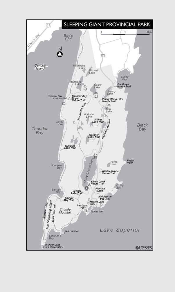

Plantain Lane
Level of difficulty 
Distance .5 km (.3mi) semi-circle
Approx. time 45min each way
Trailhead Hwy. 587, just prior to the Kabeyun South trailhead
Other Wheelchair accessible
This trail follows an abandoned Silver Islet road towards a fabulous view from a bridge over Sibley Creek.
Sea Lion Trail
Level of difficulty 
Distance .5km (.3mi) linear
Approx. time 1hr return (includes lots of time for taking in the scenery)
Trailhead The Kabeyun Trail, very close to the Kabeyun South trailhead off Hwy. 587
Although quite short and easy, this hike leads from the Kabeyun Trail to the Sea Lion landform, a chunk of diabase jutting out into Lake Superior. The formation was created by molten lava that seeped into a crack in the sedimentary rock. After the lava hardened, erosion removed the rock around it to leave the sea-lion-shaped feature in place.
Thunder Bay Bogs Nature Trail
Level of difficulty 
Distance .8km (.5mi) loop
Approx. time 30min return
Trailhead Kabeyun North trailhead off North Scenic Dr.
The best things about this trail are the 18 display boards that describe glaciers in a way children can understand.
Joe Creek Nature Trail
Level of difficulty 
Distance 1.6km (1mi) loop
Approx. time 1hr return
Trailhead Hwy. 587, just after the park entrance
If you like spring wildflowers or small waterfalls, this is your trail. It loops along both sides of Joe Creek through mostly woodland areas, although there are a few small footbridges over marsh.
Sibley Creek Nature Trail
Level of difficulty 
Distance 1.7km (1mi) loop and extension
Approx. time 2hrs return
Trailhead Hwy. 587, just prior to the Kabeyun South trailhead
This trail, which includes a marsh, a stream and beaver dams, is good for children. You’ll probably see moose.
Gardner Lake Trail
Level of difficulty 
Distance 2km (1.2mi) linear
Approx. time 1hr return
Trailhead Hwy. 587, just after the park entrance
This often-wet trail follows the remains of an old logging road to Gardner Lake. Look for migrating birds, especially boreal forest warblers, since 20 species nest in the park.
Sifting Lake Trail
Level of difficulty 
Distance 2km (1.2mi) linear
Approx. time 2hrs return
Trailhead Hwy. 587, just after the park entrance
This woodland trail leads to Sifting Lake, an area known to attract migrating birds, including olive-sided flycatchers and pine warblers.
Sawbill Lake Trail
Level of difficulty 
Distance 2.3km (1.4mi) linear
Approx. time 1hr each way
Trailhead At the south end of Marie Louise Lake Scenic Dr.
This trail follows the remains of an old logging road to join the Marie Louise Ring Road with the Sawyer Bay Trail. If you’re camping, you’ll take this trail to climb the giant.
Wildlife Habitat Nature Trail
Level of difficulty 
Distance 2.4km (1.5mi) loop
Approx. time 1hr return
Trailhead Hwy. 587, just after the park entrance
This trail is good for moose sightings.
Middlebrun Bay Trail
Level of difficulty 
Distance 4.2km (2.6mi) linear
Approx. time 2hrs each way
Trailhead Across the street from the Silver Islet Cemetery
This trail features a fen, a non-acidic area for unusual plants. The trail also leads to a secluded beach.
Sawyer Bay Trail
Level of difficulty 
Distance 6km (3.7mi) linear
Approx. time 2.5hrs each way
Trailhead The end of the Sawbill Lake Trail or the Kabeyun Trail, very close to the Kabeyun South trailhead off Hwy. 587
This trail follows an old logging road to Sawyer Bay at the base of the Sleeping Giant. Although nondescript, it’s the easiest way to reach the trail that allows you to climb the giant.
Piney Wood Hills Nature Trail
Level of difficulty 

Distance 1.3km (.8mi) linear
Approx. time 1.5hrs return
Trailhead North Scenic Drive, about 1.5km (.9mi) from Hwy. 587
This hilly woodland trail leads to a lookout over Joeboy Lake. You have a good chance of seeing a moose here in the early morning or late evening.
Climbing the Giant via the Chest Trail from Sawyer Bay
Level of difficulty 

Distance 2km (1.2mi) linear
Elevation 250m (820ft) up the highest vertical cliffs in Ontario
Approx. time 2hrs each way
Trailhead At the end of the Sawyer Bay Trail
This steep climb up the chest of the giant leads to Nanabosho Lookout. The view here is of the park and Sawyer Bay, although on a clear day you can glimpse the eastern shore of Thunder Bay to your left and Black Bay to the right.
Pickerel Lake Trail
Level of difficulty 

Distance 10km (6.2mi) linear
Approx. time 4hrs each way
Trailhead Hwy. 587, just after the park entrance
This trail was designed for cross-country skiers, but it leads to some of the park’s largest white pines.
Ravine Lake Trail
Level of difficulty 


Distance 1.5km (.9 mi) loop
Approx. time 3hrs return
Trailhead Kabeyun South trailhead
Two different lookouts, a view of Ravine Lake and a shaded cedar grove make this steady climb and sharp descent worth the effort.
The Burma Trail
Level of difficulty 


Distance 11.4km (7mi) linear
Approx. time 6hrs each way
Trailhead Near the end of Louise Lake Scenic Dr.
Birdwatchers will love the variety of species along this trail, which leads along rocky ledges, to lakes, and through stands of mature red and white pine.
Kabeyun Trail
Level of difficulty 
 to
to 

 very difficult between the giant’s feet and Lehtinen’s Bay
Distance 40km (25mi) linear around the coast, 9.2km (5.7mi) to the Chimney Trail
Approx. time 1 to 5 days each way
Trailhead Kabeyun South trailhead off Hwy. 587 or the Kabeyun North trailhead, off North Scenic Dr.
The Kabeyun Trail, which leads from the Silver Islet Cemetery near the Sea Lion all the way around the coast, around the Sleeping Giant, to the Thunder Bay lookout, is the park’s most popular trail to climb the giant. Although there are 11 campsites along its route, you can also do portions of this trail to limit your trek to less than one day. The most popular stretch is, of course, the 9.2km (5.7mi) stretch from the south trailhead near Silver Islet to the Chimney Trail.
Climbing the Giant’s Knees via the Chimney Trail
Level of difficulty 


Distance 1km (.6mi) linear
Elevation 250m (820ft) up the highest vertical cliffs in Ontario
Approx. time 1hr each way
Trailhead Kabeyun Trail, 8km (5mi) from the Kabeyun South trailhead off Hwy. 587
This is by far the best way to climb the giant. A large crevice in the rock (the “chimney”) leads over a talus slope of boulders, through and onto the giant’s knees. As you come out of the chimney on the east side of the knees, you’ll see Lehtinen’s Harbour, Tee Harbour, Silver Islet and the rest of the peninsula. The island out in Lake Superior is Isle Royale, a U.S. national park. Take the short trail to the west side of the knees to view Thunder Bay (both the body of water and the city), Pie Island and Mount McKay. Pay attention for signs of both beavers and porcupines, both of which live here year-round.
Twinpine Lake Trail
Level of difficulty 


Distance 4.7km (7.6mi) linear
Approx. time 3hrs each way
Trailhead Either the Kabeyun Trail about 8km (5mi) from the Kabeyun North trailhead off North Scenic Dr. or the Burma Trail about 2.6km (1.6mi) from the Louise Lake Scenic Dr. trailhead
This very wet trail connects the Kabeyun Trail and the Burma Trail. You’ll pass a very large double lake, where white-tailed deer are known to feed.
Talus Lake Trail
Level of difficulty 


Distance 5km (3mi) linear
Approx. time 3hrs each way
Trailhead Either the Kabeyun Trail about 7.5km (4.7mi) from the Kabeyun South trailhead or the Sawyer Sawbill Lake Trail about 5.8km (3.6mi) from the Louise Lake Scenic Dr. trailhead
This trail leads along cliffs and through meadows between the Sleeping Giant and Talus Mountain. Highlights include three lakes, talus slopes, and a waterfall.
Climbing the Giant’s Knees via the New Top of the Giant Trail
Level of difficulty 

Distance 3km (1.9mi) linear
Approx. time 2hrs each way
Trailhead At the end of the Talus Trail
Volunteers spent a summer building the stairs along this twisting vertical climb to the top of the giant. Their efforts give visitors a very pleasant alternative to the rapelling climb of the original Chimney. Once you get to the top of the giant, it’s another 2km across to the spectacular views of the harbour on the west.
Location White River
Number of trails 4
Total distance 20km (12.4mi)
Interesting features Beavers, wolves, porcupines, rabbits, blue herons, relative seclusion
Facilities/Services None
Cross-country skiers maintain these trails on crown land, but locals frequently mountain bike and hike on them during the summer. You’ll see lots of wildlife, very few (if any) people and interesting vegetation. In exchange, you must be willing to blaze your own trail in spots and accept the occasional rickety footbridge.
To get to three of the four trails, you’ll cross a 30m (100ft) beaver dam with no rails and a lot of loose branches.
Getting There
Drive east of the information centre on Highway 17 in White River to Highway 631. Drive north for 2km (1.2mi) towards Hornepayne. The parking area and sign is on your right.
Further Information
The Corporation of the Township of White River
PO Box 307, 102 Durham St.
White River, ON P0M 3G
807-822-2450
Timberwolf Trail
Level of difficulty 

Distance 10km (6.2mi) loop
Approx. time 4hrs return
Trailhead Hwy. 631
This very long loop leads up and down a boreal forest ridge where wolves are known to live. It’s also a very popular trail for mountain bikers.
Jackrabbit Trail
Level of difficulty 


Distance 4km (2.5mi) loop
Approx. time 2hrs return
Trailhead Hwy. 631
This trail is the main trail crossing the beaver dam and circling an unnamed lake. You’ll see lots of boreal chickadees and gray jays. Look for bunchberry, yellow clintonia and large-leaved aster in the boggy lowlands.
Beaver Trail
Level of difficulty 


Distance 2km (1.2mi) linear
Approx. time 1hr each way
Trailhead Partway along the Jackrabbit and Whiskey Jack trails
This very wet trail joins the Jackrabbit and Whiskey Jack trails to form a very short loop closest to the unnamed beaver lake. You’ll see lots of beaver dams and beaver meadows and most likely some beavers as well.
Whisky Jack Trail
Level of difficulty 


Distance 4km (2.5mi) linear
Approx. time 2hrs return
Trailhead Halfway along and near the end of the Jackrabbit Trail
This trail joins two portions of the Jackrabbit Trail to form a shorter loop and avoid a bridge crossing.


