Heart Mountain 2135 m moderate
Mount Yamnuska traverse 2240 m easy
Gap Peak traverse … 2485 m moderate
… to Mount Fable 2702 m moderate
East End of Rundle 2590 m easy
Grotto Mountain 2706 m easy
Middle Sister 2769 m easy
Mount Lady Macdonald 2605 m difficult
The Tit 2500 m moderate
Ha Ling Peak 2408 m easy
Big Sister 2936 m moderate
Mount Lawrence Grassi 2685 m moderate
Rimwall Summit 2680 m moderate
Mount Baldy 2192 m moderate
This chapter covers scrambles in or near the Canmore Corridor as well as at the extreme north ends of Kananaskis Valley and Spray Lake. Because of their close proximity to Canmore and Calgary, these outings are well travelled and attract many enthusiasts for much of the year.
Geographically, this area is part of the Rocky Mountain Front Ranges, and because of its easterly position it is generally comparatively dry due to the rain shadow effect. Peaks to the west collect more of the moisture when normal west to east weather patterns prevail.
This was not the case in 2013, however, when in mid-June a low-pressure weather system pushed up against the Rockies from the east and stubbornly rotated in one spot. It dumped historic amounts of rain in about 36 hours, affecting a wide area from west of Banff east to Calgary and from Waterton Park in the south almost up to Saskatchewan Crossing. Parts of southeastern BC were also affected. Apart from damage to homes, businesses and property, unparalleled damage was done to hiking trails, bridges and roads in the hardest-hit locations. Hundreds of people were evacuated from Kananaskis by helicopter; Banff and Canmore were inaccessible by road for days. Tiny trickles became raging torrents that destroyed homes, such as those along Cougar Creek in Canmore. Valley bottom trails were obliterated. As a result, access to some peaks is less pleasant due to uprooted trees and boulders left behind. In particular, Mount Fable and Middle Sister access was noticeably impacted.
Apart from events such as these, the scrambling season for this area tends to be longer than areas west, due to warm, strong chinook winds that in winter periodically blast peaks like Heart and Grotto Mountain clear of snow. Christmas and New Years ascents are not unheard of.
The Front Range topography in this area is defined by long limestone ridges that are generally aligned northwest to southeast. Strata display a pronounced dip to the southwest, and as in much of the Rockies it is this aspect that usually affords an easy way to the top. An exception to this is Mount Yamnuska, which flaunts a nearly vertical south face. This is because of a locally significant geologic event called the McConnell Thrust.
Like Kananaskis Valley, the Canmore Corridor is a good area to frequent when unsettled weather hits the Rockies. By heading up almost any peak described in this chapter, you are far more likely to salvage a day of poor weather than if you headed farther west. Unfortunately, unbridled development threatens to ruin the charm of Canmore. Since the original edition of this book, the rate of construction has been unprecedented. Comparing the view from Lady Macdonald today to that in 1990, one sees a patchwork landscape of hotels, condos and golf courses, none of which existed before. Even Mount Lady Macdonald suffered the indignity of construction on the shoulder below the top. Local helicopter pilot Bob Johnson’s scheme was intended to shuttle tourists but soon fell flat. He later abandoned the project, and in 2013 taxpayers paid for the cleanup.
Apart from development, this little part of the Rockies is a pretty place and scramblers can pass many pleasant hours ascending nearby peaks. To reduce impact on slopes of certain peaks, Canmore Trailminders, a local volunteer group, has constructed trails to the top of a few of the more popular summits. Because south faces of these mountains come into shape early in the season, particular spots attract a sizable population of bighorn sheep. Sheep are hosts to ticks, though, so always check yourself for these critters (ticks, that is!) after a spring or early summer ascent. Ticks are especially prevalent on Mount Lady Macdonald. See the “Hazards” section in the front of the book regarding tick-borne diseases.
Access The Trans-Canada Highway runs through the middle of the Canmore Corridor, with Spray Lakes Road beginning within the town and travelling south. The north end of Kananaskis Valley is reached via Kananaskis Trail (Highway 40), which intersects the Trans-Canada 65 km west of Calgary.
Bow Valley Trail (Highway 1A), on the north side of the Bow River from Seebe to Canmore, accesses mounts Yamnuska, Fable, Gap and Grotto.
Facilities Canmore offers all visitor facilities and is a major tourist hub. Hotels, bed and breakfasts, bars, fast food places, laundromats and the like are in abundance. At Exshaw, on Highway 1A, a combination gas station, cafe and grocery store is found – perfect for a fix of junk food or a cold beer after a trip up Mount Fable.
Accommodation Any type of accommodation you might want is available in Canmore. You can also find a rustic campground on the west side of the Spray Lake Reservoir across Three Sisters Dam, about 18 km from Canmore. Until recently this campground had been free, but in their continuing money grab the provincial government now charges for these primitive sites.
For a cheap sleep in Canmore, visit the Alpine Club of Canada Clubhouse, 2 km east of Canmore on Highway 1A at the foot of Grotto Mountain. Campsites, budget motels and gas stations are also found at Dead Man Flat east of Canmore.
Information For general information, Tourism Alberta is at the west end of the gas station strip in Canmore near the west overpass. Trail and campground information is available at the Kananaskis Country counter in the Provincial Building across from the Rose and Crown Pub. There is also an information centre at Bow Valley Provincial Park near Seebe on Highway 1X.
Kananaskis Country head office in Canmore 403-678-5508
Barrier Lake info 403-673-3985
Kananaskis Village 403-591-7555
Peter Lougheed Provincial Park 403-591-6322
Backcountry permits 403-678-3136
Updated trail info: kananaskisblog.com.
Emergency The RCMP maintains a station at the corner of Elk Run Boulevard and Bow Valley Trail, just east of the townsite: 403-678-5519
In the event of a climbing-related accident, Kananaskis Country rangers would provide rescue assistance. There are no info centres or ranger stations anywhere along Spray Lakes road or Smith-Dorrien Highway, only a pay phone located close to Three Sisters Dam, 18 km south of Canmore on Spray Lakes Road.
Kananaskis Country Emergency Services 403-591-7755
Emergency 911 service is also available through most of K-Country. Specify which area you are in.
Difficulty: Easy, with one moderate step via northwest ridge
Round-trip time: 3–6 hours
Height gain: 875 m
Maps: 82 O/3 Canmore; Gem Trek Canmore–Kananaskis Village
Heart Mountain is close to Calgary and can often be ascended year-round due to chinooks that blast the route bare. Most popular is a pleasant loop that includes a higher summit officially named Grant MacEwan Peak. While a parking lot has been constructed just west at Lac des Arcs overpass, many parties still use the roadside ditch at the foot of the mountain as the starting point. The trail from Lac des Arcs requires backtracking once you reach Heart Creek, as the trail is located above the creek. As an early season conditioner or a short day out from the city this little peak is a perfect choice.
Park at the signed parking lot for Heart Creek trailhead on the south side of the Trans-Canada Highway at Lac des Arcs interchange, 75 km west of Calgary and 36 km east of Banff.
From the parking lot hike the trail paralleling the Trans-Canada Highway and cross Heart Creek to the foot of the ridge. The way up is obvious, even without all the markers. Follow the path as it climbs rapidly up the right side of the “heart” shape. Slabs on the ascent are a pleasant change from scree, while more exposed spots can be avoided by a short detour left into the trees. Two-thirds of the way up, the ridge eases, and to continue you scramble up a steep 3-m-high wall identified by an obvious marker. You need not bother looking elsewhere for an easier place to ascend, as there isn’t one.
You soon reach the first summit, which is Heart Mountain. Some parties decide this is far enough, but a mere 25 minutes hike southeast takes you to Grant MacEwan Peak. This summit is actually higher and once you’re there it makes more sense to continue on and do the loop.
From Grant MacEwan, head northeast along an open, rounded ridge. Descend a short grassy slope, tramp across a saddle and attain a minor high point (322544). The ridge coaxes you along on an open northwesterly course before gradually descending into mature forest toward the highway. After crossing debris from the 2013 flood, join up with the Quaite Valley trail, which parallels the highway just past the power line. Pass a pond and continue back to Heart Creek.
There is another option for exploration here. If you have attained the second summit, at 318550, you can add an interesting extension along an open ridge that leads southeast to twin high points (325537) overlooking Barrier Lake. The ridge gently descends, then climbs back up again. The crux of this extension is a drop-off about halfway between Heart Mountain and the two 2300 m (7500 ft. on the map) unnamed points. There is no way to avoid this brief test-piece – you must climb down here. The descent involves little more than 5 m of careful scrambling but it is much steeper terrain. You will be returning the same way, but climbing back up this rock step is a whole lot easier.
During the Late Cretaceous to Middle Eocene periods, roughly 85 million to 45 million years ago, tremendous compressional forces folded the upper strata of Heart Mountain into a plunging syncline. When seen from across the valley at Exshaw, it forms a nearly perfect valentine heart.
From a farming background, Dr. Grant MacEwan was an educator, administrator, mayor of Calgary, Lieutenant Governor of Alberta and an Officer of the Order of Canada, although this is but a partial list. He received numerous awards throughout his lifetime and had more than 20 books published.
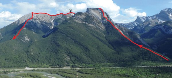
Heart Mountain as seen from Exshaw Mountain, showing the loop. C: crux; S: summit of Grant MacEwan Peak.
Difficulty: From west, easy; from east, easy using fixed chain at crux
Round-trip time: 4–6 hours
Height gain: 900 m
Maps: 82 O/3 Canmore (shown as Mount Laurie); Gem Trek Canmore–Kananaskis Village
Yamnuska is a popular early-season outing and usually bustles with activity. Easy access and a variety of routes attract rock climbers, particularly when bigger peaks are snowbound. Scramblers will find the ascent a good conditioner. Owing to its easterly location, Yamnuska often escapes bad weather plaguing peaks to the west. The Yamnuska environs are well known for their diversity of plant life, and in early season, purple crocuses of various shades carpet the south-facing hillside. An east to west traverse is popular and finishes with a rapid descent down huge scree slopes. Try this from about May on.
Mount Yamnuska was formed by a geological movement called the McConnell Thrust. Eldon limestone from the Cambrian period (the steep southeast face) was pushed up onto much younger and softer sandstones of the lower slopes. The usual younger-over-older sequence of stratification, or “layering,” was thus reversed, resulting in a geologically disorganized mountain. The demarcation line is evident at the foot of the steep face.
From the Seebe intersection (Highway 1X) on Bow Valley Trail (Highway 1A), drive east 2 km, turn left and follow the road 200 m to the parking lot.
The trail starts by the large info sign at the west end, crosses the quarry access road and rises through aspen forest east of the quarry. Within 15 minutes the trail levels and splits. The right-hand fork (hikers and horses) is less steep and longer, gently rising to the crest of the shoulder east of the peak. From the shoulder, simply hike up to the peak. Most scramblers and climbers instead continue straight ahead at this junction, on the path rising west. At the next junction (unsigned), go right. The left branch leads west to the bottom of huge rubble slopes below the face and is usually used on descent. The preferred, right-hand trail rises steeply to reach the peak’s east end and continues around to the northeast side. The trail descends below or goes up through a split and crumbly buttress; then myriad trails head for the ridge crest above. Follow the paths west across rubble toward a shallow gully leading to a small notch in a rock wall on the skyline, the easiest and most popular way past here. In 2014 Kananaskis Country staff marked the correct path with blue paint because way too many people were requiring helicopter rescue on this relatively easy ascent. Watch for it along the way.
The route is straightforward until you reach a drop-off above a gully, the crux, whereupon you have three options. The easiest and most popular way is to go slightly downslope, gain a horizontal ledge and traverse horizontally using the fixed chain. You can also downclimb a steep 5-m groove toward the gully. Some parties liven it up by continuing to the ridge and then scramble down 10 m of short rock steps. Holds are good, but the downclimbing feels fairly exposed. If in doubt, use the chain route.
Immediately beyond, at a steep wall alongside a notch in the summit ridge, either detour below and back up (easiest) or traverse across on small ledges. The remainder to the top is easy, with the trail topping out a few metres north of the cairn. At one time the cairn included rocks from Russia’s Pamir Range, brought back by Calgary climbers.
On descent, a beaten path in fine brown shale gives way to a stretch of slabs followed by coarser rubble as it winds down around to the west end. Stay high as you traverse around and don’t be lured into gullies heading steeply down the back side. Early in the season, snow can persist on the back side, requiring care as you cross it. At the west end, unpleasant hard dirt leads down below the face. Traverse across below the face, then plunge step straight down huge scree slopes. Watch carefully for a cairn near treeline where the proper trail unexpectedly traverses horizontally east just before the rubble runs out. The path meanders east above the quarry to rejoin the ascent trail.

Morning light on Mount Yamnuska as seen from near the casino. The route ascends the east end, goes around to the north (back) side, then descends the west end.
Difficulty: Moderate scrambling and slight exposure traversing from Gap Peak 2485 m to Mount Fable 2702 m
Round-trip time: 12+ hours; 6–9 hours round trip for Gap Peak
Height gain: 1425+ m
Maps: 82 O/3 Canmore (Gap Peak unmarked at 245612, Mount Fable unmarked at 242642); Gem Trek Canmore–Kananaskis Village
Mount Fable is a shapely peak hiding north of Grotto Mountain, and when seen from Trans-Canada Highway it rises majestically skyward in contrast to an ugly smokestack in front. The standard route used to be via Exshaw Creek with an option to traverse a high, 3-km-long ridge back to Gap Peak and Highway 1A. Since Bob Spirko found a good route up Gap Peak from the 1A, the reverse traverse has become popular. June 2013 flooding ruined the trail up Exshaw Creek, so this reverse traverse from Gap to Fable is now a more logical way to ascend both Mount Fable and Gap Peak. This is a dry area and the route is sometimes feasible by May.
From the hamlet of Exshaw on Bow Valley Trail (Highway 1A), continue west for 3.5 km to Grotto Pond picnic area and drive a further 400 m. Turn right into a small parking area by the Baymag cement plant.
Spirko’s route heads north across the gravel bed and up onto the wooded ridge, keeping slightly left at first to dodge a cliffband in the trees. If you trend generally left through the forest, you should find a flagged trail and in about an hour emerge onto open shale slopes and numerous gnarled pine trees alongside. At the first cliffband, hug the base and traverse right (east). As soon as possible, head up a slope of loose rubble, angling right for firmer footing, and reach the base of the second cliffband. Here you traverse left (west) until you can easily scramble around this second band. Continue up long, tedious rubble slopes leading to a scrambly bit above that marks the start of the ridge to Gap Peak. This ridge is longer than you might expect and has enough scrambling and exposure to make it entertaining, especially when windy. The small summit is the logical snack spot to study the traverse to Mount Fable. John Martin may have been the first person to traverse here from Mount Fable and he named this point Gap Mountain, for nearby Gap Lake. I have taken the liberty of referring to it as Gap Peak to avoid confusion with Gap Mountain near Highwood Pass.
The connecting ridge to Mount Fable loses elevation for the first half and has a few steps in it. It then gradually climbs back up and curves right (east) to a high point. From this high point the route drops slightly and joins the west ridge of Mount Fable. None of the scrambling along here is difficult, and the west ridge of Fable is likewise straightforward if snow-free, with just one narrow part. Views include unnamed summits encircling Cougar Creek to the north and more familiar peaks lying south.
Descent from Fable is via big, brown rubble slopes on the southwest side which lead to an obvious, bouldery drainage. Farther down this drainage you should be able to slake your thirst. Continue down this streambed to intersect the main valley of Exshaw Creek (at 265622), which is also bouldery. Here you turn right and head south for the hamlet of Exshaw. A good trail existed here until the 2013 flood, which washed away both the trail and parts of Exshaw.
When you reach the 8-m-high dam just before the hamlet, hug the hillside on the right (west) side and descend a rock step down to the creek. The adjacent road is off-limits due to rockfall danger from Lafarge’s quarry, and you are trespassing on Lafarge land if you use it. At the dam the other option is to follow an uphill trail on the east side of the creek which traverses fairly high, then descends when closer to Exshaw
Ideally you’ll have another car waiting for you in Exshaw or at least a bike to pedal 4 km back to the Baymag plant. Clever folks will decipher how to reverse this description and go up Exshaw Creek to do Fable just as before, bouldery or not. It takes about 1.5 hr to the turnoff to Mount Fable, while the round-trip ascent is some 7–10 hours. Parking is on Mount Allan Drive next to the footbridge just past the post office (as of 2015).
Fable’s first attempt party in 1947 failed and they attributed it to time wasted owing to bush. The second attempt party had no such trouble. Was the bush a mere fable? The successful group thought so, and since then the name has gained local recognition.

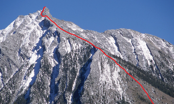
Gap Peak from the Trans-Canada Highway, showing ascent route from the Baymag plant. The summit is just barely visible in the distance.

Mount Fable ascent route and the traverse as seen from Gap Peak. F: Mount Fable.
Difficulty: An easy scramble via south scree slopes
Round-trip time: 3–5 hours
Height gain: 900 m
Maps: 82 O/3 Canmore (unmarked 105598); Gem Trek Canmore–Kananaskis Village
The East End of Rundle is a good early-season objective that requires minimal effort. This is not, of course, Rundle’s true summit, but the eastern extremity of the 12-km-long uplift. Steep, high faces above the canal host several rock-climbing routes; the gentle south slopes serve as a climber’s descent route. It is also a popular jaunt for scramblers and hikers, as the snow on it often disappears by mid-May.
Follow Spray Lakes Road from Canmore past the Canmore Nordic Centre to Whiteman’s Gap and Goat Creek parking lot, 8.6 km past the Bow River bridge.
From parking, hike back along the road and look for a man-made trail between the Bow Crow Forest sign and the second set of powerline poles. It leads easily through ever-thinning forest to treeline. You can then either angle left and aim directly for the high point, going through a rock band via a gully, or continue straight uphill, gain the skyline ridge and scramble up that way. The gully is preferable on descent. Above are two minor points five minutes apart. On one unforgettable occasion years ago, the higher point hosted two scantily clad, much-surprised female sunbathers. Sadly, not much has been seen of them since.
The lengthy traverse of Rundle is often started from this end, and though initial stages are straightforward, sections toward the main summit become technical and require a rope.

East End of Rundle showing ascent route from Whiteman’s Gap.
Difficulty: Never more than moderate scrambling by these routes
Round-trip time: 5–8 hours
Height gain: 1425 m
Maps: 82 O/3 Canmore; Gem Trek Canmore–Kananaskis Village
Grotto Mountain is a Canmore landmark with four different ascent routes to choose from. It sees a lot of ascents by these various routes, sometimes in combination for a traverse or just for variety. The faithful are often making summit pilgrimages by April. Approaches are short, regardless of route.
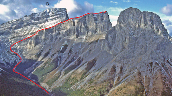
As seen from the highway the four routes are, left to right: Cougar Creek Route, Northwest ACC Trail, Direct Route and East Route.
By combining an ascent of the true northwest ridge starting from Cougar Creek and descending the East Route, a long traverse of the peak is possible. The start is the same as for Mount Lady Macdonald. From where the Lady Macdonald trail turns left and leaves the creek for the hillside, look across to the opposite side and notice in the trees an obvious trail angling up sharply left on that hillside. This is shortly before the creek bed narrows and enters the canyon. Follow this trail up into forest as it wanders up the northwest ridge, noticing blazed trees and cairns en route. If you lose the path, simply head uphill and it will probably soon reappear to one side or the other. Upon reaching the first rock band at about 2/3 height, follow the trail left along the base to scramble up a 6 m chimney or go slightly farther to an easier rocky slope. At the second rock band, traverse east and either scramble up the first weakness or traverse farther east and reach much easier terrain. Above there, a line up to the right through forest will intersect the Northwest ACC trail. Otherwise, simply head uphill to the summit ridge. Cougar Creek route is probably the least-used route.
For the Northwest ACC Trail and the Direct Route, drive to Indian Flats Road, 4.2 km east of Canmore on Bow Valley Trail (Highway 1A). It leads past the horse stables to the Alpine Club of Canada clubhouse. Do not park in the ACC guest lot; park before the sheds on the west shoulder of the road. The Direct Route is also readily reached from a small pull-off on the north side of Highway 1A, 1.3 km east of Indian Flats Road. You could also follow the gravelly drainage from the 1A between these two locations.
As seen from the highway, this route lies more toward the left-hand end of the mountain but right of the Cougar Creek route. Built in 1995 by volunteers from the Rocky Mountain section of the ACC, this is a nicely graded trail with switchbacks that cunningly avoid all cliff bands on the southwest-facing flanks of the peak. It is situated between the huge gully and the northwest ridge. This route begins just below the ACC parking lot near utility sheds, an obvious trail angling up to the right. Follow this to the ridge, then over to the crest of the next ridge right (east). You’ll see horse corrals below at this point. Immediately past here, just 15 minutes from the parking lot, notice an important split in the trail. The Northwest ACC Trail goes straight ahead; the trail branching right is the Direct Route. The ACC trail is easy to follow, and if you are descending this route, watch for a large cairn at treeline. A long plod leads to the ridge and false summit before reaching the top. You may not even notice the small tunnel through the rock beneath you, mere minutes before the true summit.
This is the shortest and steepest way and takes a direct line from base to summit, staying right of a massive gully system at 192600 draining the southwest slopes. If parked along Bow Valley Trail, angle left, then stay to the right of and above the creek bed to the base of the peak. From the ACC sheds, follow the Northwest ACC Trail as described above for 15 minutes. At the 4th junction, a 4-way one, take the right-hand fork down (east) and cross the streambed. Immediately turn left and ascend a good trail, passing an Echo Canyon sign farther up. Any slabs posing difficulty can be avoided by staying close to the huge gully, and upon reaching treeline, simply tramp up rubble to the summit cairn.
The East Route up Grotto begins 4.8 km east of Indian Flats road and 7.8 km west of Exshaw. It shares a common starting point with nearby Rat’s Nest cave. Initially the trail wanders through forest, then stays just to the left of a deep, narrow gully system. Expect occasional short bouts of scrambling, including a diagonal traverse left to right on a ledge just before reaching a steep rock wall below the viewpoint. The trail contours along the base of this steep wall, then switchbacks around left to top out at a wonderful, airy viewpoint for the Canmore Corridor. For many, this overlook is the actual destination. It makes a great spot to snack before tackling the upcoming finale.
Above the viewpoint, a glance left reveals a large purple scar where surface rock peeled away and avalanched partway down the mountain, revealing smooth slab underneath. If memory serves, this was relatively recent, caused by frequent blasting in the quarry below. Alongside here is a huge, airy drop. The last few trees give way to rubble and a broken, blocky ridge rising toward the false summit. It is less toilsome to stay on the crest rather than trudge through masses of rubble to the right. Once you reach this false summit, allow 30–45 minutes for the true summit farther left (northwest), where repeater towers are visible.
In 1858, Bourgeau and Hector of the Palliser Expedition discovered a large cave or grotto in the mountain, for which it is named.

Grotto Mountain routes. C: Cougar Creek route; ACC: Alpine Club of Canada route; D: Direct Route; E: East Route; S summit.

Grotto routes: D: Direct Route; E: East Route; S: summit; V: viewpoint; F: false summit.
Difficulty: An easy scramble from Stewart Creek
Round-trip time: 8+ hours
Height gain: 1400 m
Maps: 82 O/3 Canmore; Gem Trek Canmore–Kananaskis Village
When this guidebook first appeared in 1991, Middle Sister was somewhat ignored. It later saw many visits and a decent trail had developed up Stewart Creek until the record-setting flood in 2013. With all the rock and debris now filling the drainage the trek is much more tedious and unlikely to ever get much better. The route may be in shape by May but take an ice axe for lingering snow patches higher up on early season trips.
There are two ways to reach the starting point. From the bridge over the Bow River in Canmore, follow Three Sisters Parkway east along the benchlands past condominiums. Ignore the access road down to the Trans-Canada Highway and park at the farthest point east, near a gate. As of 2013 this was 6.8 km from the Bow River bridge in Canmore. From the Trans-Canada this point is reached via the overpass 3 km east of Canmore. Take the exit, drive uphill to the intersection, turn left, go about 700 m and park.
From the gate, walk east on the road for 20 minutes and watch for an access road branching off right. This was obliterated in 2013 and was being rebuilt soon after. Follow an access road toward the drainage on the left side and cross to the right-hand side just before a canyon where a good trail heading upstream exists in the forest. This is short-lived and you are soon in the streambed muddling your way over and around masses of rock debris and criss-crossing the stream. Occasionally you can still find bits of the old trail on the left side. Farther up, the valley opens up somewhat.
When you are east of Little Sister the creek forks and you branch to the right. About 20 minutes farther, a major avalanche slope comes down. Continue straight up the valley. The terrain is tedious and steep hillsides confine you to the drainage. Impatient parties in the past have made a dash for a summit as soon as they saw a col high above on the right. That one is incorrect. That is the Little/Middle Sister col – you are headed to the Big/Middle Sister col way up near the end of the valley, so keep on trudging.
The streambed curves right and rises steeply to escape treeline. The bottom of the drainage here is bouldery and unpleasant. It is better to gain the top of the open hillside on the right and hike along above until you can easily traverse back into the drainage at a point well above the steep, ugly, bouldery bits below. Continue upvalley on rubble.
The simplest line up to the Big/Middle Sister col is a rising angle from left to right and should be obvious. In fact, the farther upvalley you go, the more obvious it becomes. You will be below and east of Big Sister when you start angling up to Middle Sister. Although it has been a long thrash to here, thankfully you have gained much of the total elevation. Tramp up slabs and scree to the Big/Middle Sister col, where views the length of the corridor await.
The worst is over and now you simply walk to the summit. Although Big Sister is close, it is plain to see that no simple route exists up from this side. The normal route ascends the opposite side and is reached from Spray Lakes Reservoir. Once you have heard enough sightseeing helicopters buzzing by, return the same way.
Stewart Creek and Middle Sister from Wind Ridge, showing ascent route. B: Big Sister. Little Sister is to right.
Difficulty: Final 50 m of route is difficult and exposed
Round-trip time: 4.5–7 hours
Height gain: 1300 m
Maps: 82 O/3 Canmore (unmarked 179649); Gem Trek Canmore–Kananaskis Village
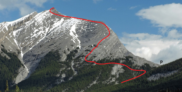
Mount Lady Macdonald is a classic early-season conditioner with an exciting finish. Low snowfall and chinook winds make it feasible by April most years, and it is one of the most frequented scrambles around Canmore. Most of it is a hike, but many parties find the final, narrow ridge too exposed and do not actually reach the true summit.
Follow Elk Run Boulevard through Elk Run Industrial Park just east of Canmore off Bow Valley Trail to the wide gravel outwash from Cougar Creek, which flooded badly in June 2013. The parking area was wiped out at that time but has been repaired.
The ascent trail begins on the left side of the drainage almost as soon as you enter the trees but before the canyon. It is an obvious, well-beaten path branching left. In 1990 a flash flood wiped out a boulder dam placed across the canyon, giving homeowners a good scare. In 2013 more serious flooding destroyed yards and damaged many homes in this illogical location.
The trail ascends the open hillside to the left immediately before the canyon. You will have no trouble finding this well-worn track. Be sure you branch right at a fork after some 10 minutes where the trail angles upward to the right. This is about the only place you could get off route. The path climbs steadily through forest, granting increasingly better glimpses of the Canmore Corridor as you grunt upward.
It was not uncommon to see bighorn sheep on these slopes in the past. Barring barking dogs in the area or helicopters overhead, who knows, you still might see them, too. Sheep like to loll in the spring sun, unwittingly offering woodticks a warm body to bite into. Lacking sheep, woodticks find an unwitting hiker even better fodder, as there is less hair to contend with (usually)! Springtime is the worst – or the best if you’re a tick. Remember this as you too loll in the sun, and check for ticks afterward.
When I first ascended this peak in 1983, these were little more than forested slopes. By comparison, some parts are now deeply rutted, testimony to the peak’s popularity. Canmore Trailminders, a local volunteer group, has built a new section of trail to avoid the most eroded area, but in places may be hard to discern owing to a myriad of other trails.
Higher up, the trail parallels slab, forming a well-defined ridge, and leads to a small, open plateau below the summit scree slopes. A hare-brained scheme to build a teahouse here and fly tourists up to it by helicopter was tried briefly but fell flat. Thankfully, all traces were removed, but Albertans paid for the cleanup.
The most common finish to the top of the peak angles diagonally left across scree and slabs toward the highest point on the skyline. Watch for a good trail and at least one big cairn, but if it is still snowy, you can head directly up to the ridge above. Although the visible highpoint is not the true summit, the summit is close by. On the skyline ridge the terrain changes drastically. You must carefully cross a narrow, exposed ridge which is a steep slab on the west side and overhangs a big drop on the east side. The last 15 metres or so are most demanding, involving scrambling on good rock and small footholds, but it isn’t for everyone. Once during the 1990s I arrived at this point and waited my turn while a young woman returned from the summit and nonchalantly walked along the very crest of this ridge. To say I was impressed would be an understatement— I had never seen anyone do that and hurriedly checked the register when I got there. It was Sara Renner, a name I knew because her family ran Mount Assiniboine backcountry lodge. Sara excelled at cross-country skiing and in 2006 she won an Olympic silver medal at Turin, Italy, in the team sprint event. Since 2014 this hometown favourite and her family have owned the acclaimed Paintbox Lodge in Canmore, a building that once housed the Canadian School of Mountaineering, where I had taken my original climbing courses.
From the summit you can look east to the headwaters of Cougar Creek or enjoy the myriad peaks lying south and west. Anyone who has visited in the Robertson Glacier area might recognize Mount Sir Douglas: look between Mount Lougheed and Big Sister. Mounts Temple and Hungabee of the Lake Louise group are visible as well, to the northwest. Those who have scrambled up here regularly cannot help but notice the phenomenal pace of expansion and development, not only at the foot of the mountain, but throughout the whole Canmore Corridor.
Lady Susan Agnes Macdonald, wife of Canada’s first prime minister, lent her name to this peak. Upon completion of the transcontinental railway, this adventurous woman insisted on riding on the locomotive’s cowcatcher for better views as the train clattered from Lake Louise toward Golden. Sir John thought the idea “ridiculous.” Lady Macdonald, however, was undaunted and declared her vantage point “quite lovely.”

Mount Lady Macdonald from Cougar Creek Bridge. S: summit; P: plateau.
Difficulty: A moderate scramble with exposure and one harder step
Round-trip time: 4.5–7 hours
Height gain: 1200 m
Map: 82 O/3 Canmore (unnamed point at 164660); Gem Trek Canmore–Kananaskis Village
This minor summit in the Fairholme Range overlooking Canmore is being renamed, but as of press time the new name had not yet been chosen. It is the high point of a ridge jutting out west between mounts Lady Macdonald and Charles Stewart. The ascent offers interesting, exposed scrambling near the top. Snow-free conditions are required; try from June on.
From the Canmore west overpass, drive 800 m along Harvie Heights Road to a small parking area on the north side. The wide outwash from a drainage left of the peak reaches the road a short way farther along and leads towards the peak; The Tit is obvious to the northeast.
Head through forest toward the peak, staying right of the drainage. This will lead to the base of the triangular mountain face. Then hike uphill through thinning trees. The object is to gain the left-hand skyline ridge. Higher up, this ridge becomes a little daunting with exposure and slabby bits until the angle eases near the summit “nipple.” At that point, close scrutiny will reveal all sides to be steep or overhanging, with the exception of the left (northwest) side. Conditions here too need to be dry, as you must traverse steepish gullies until easier terrain allows you to scramble up and back to the right to reach the top. In case you are wondering, the higher point to the northeast does not have a name. Once you’ve enjoyed the view without the crowds, return the same way.
The Tit as seen from the highway. The route circles left at the top.
Difficulty: An easy ascent via southwest slopes
Round-trip time: 2.5–4 hours
Height gain: 700 m
Maps: 82 O/3 Canmore (unmarked 123573); Gem Trek Canmore–Kananaskis Village
Overlooking Canmore, this ascent is short, simple and, since trail improvements, much less steep. It is a favourite pilgrimage of locals, and paragliders sometimes use it as a launch when the wind co-operates. The referenced coordinates show the actual location of the mountain and it is this point that concerns rock-climbing enthusiasts and scramblers. Nearby Mount Lawrence Grassi may be reached if you’re good at routefinding but is usually done separately from along the canal. In between these two is a point called Miner’s Peak that is easily reached. Ha Ling Peak is a popular season starter and should pose no problem from mid-May on.
Follow Spray Lakes Road from Canmore townsite past the Nordic Centre to Whiteman’s Gap and park in the Goat Creek parking lot, 8.6 km past the Bow River bridge. Cross the road and walk uphill to the bridge over the canal. Immediately behind a small building is a well-worn path beaten into thick moss. For years, this was the climber’s descent route.
In 1997, Canmore Trailminders, a group of hardworking local volunteers, revised the trail and now it is a straightforward trek suitable for anyone who appreciates good views without technical difficulties.
Follow the path as it climbs lazily through thinning coniferous forest, gaining about 400 vertical metres to treeline, whereupon the western panorama unfolds. The trail angles upward and to the right toward the ridge and then heads up and left to gain a final 300 m. The giddy drop down the northeast side is a real contrast to the gentler ascent slopes, but please don’t roll rocks down this sheer precipice – there may be climbers on their way up! Mount Temple is the highest peak visible to the west; part of the impressive Royal Group lies to the south; and should anyone care, smoggy Calgary huddles on flatlands to the east.
Although it is feasible to traverse over to reach Mount Lawrence Grassi at 127567, expect problematic routefinding between downsloping ledges. It is much more difficult than what you’ve just accomplished and requires a keen eye to discern the route. Apparently, many are unable to pick it out. Should you opt to try, you can easily walk off from that summit to the canal via the west slopes. Otherwise, simply return the same way.
This mountain was called Chinaman’s Peak until 1997, when a Calgary Chinese businessman found the name offensive and formally protested to the Alberta government. Much controversy ensued, but in 1998 it was officially changed to honour the Chinese miner who first ascended it back in 1886. Ha Ling was reputed to have made the round trip on a bet in 6 hours, and when skeptics couldn’t see his summit flag, he made the ascent again with witnesses firmly in tow.

From the East End of Rundle, the back side of H: Ha Ling Peak is just a steep hike on a trail. M: Miner’s Peak; G: Mount Lawrence Grassi.
Difficulty: A moderate scramble via southwest slopes
Round-trip time: 5–8 hours
Height gain: 1200 m
Maps: 82 O/3 Canmore; Gem Trek Canmore–Kananaskis Village
Big Sister is the highest of the photogenic trio called Three Sisters, which rise gracefully above Canmore. It is an attractive mountain readily ascended by southwest slopes on the back side, and is downright enjoyable. A steep snow patch that lingers along north-facing slopes near the top often foils those who attempt it too early in the season, even with an ice axe. Try from late June or July on.
Follow Spray Lakes Road from Canmore and park in the big gravel pit across from the dam, 17.3 km from the Bow River bridge in the townsite.
From the gravel pit you’ll see a huge gully system that drains the back (southwest) side of the peak. Find the well-trodden ascent route that starts on the slope immediately left of the bottom of this gully. This path quickly gains elevation as it rises through forest, staying well above the leftmost branch of this gully system.
The route continues rising steeply through thinning forest, and not until near treeline is there any respite. Now you have two choices. The simpler option is to descend the steep wall on your right. You will probably have to backtrack a short distance to find it (cairn). Notice the cavelike hole at the base of the wall where you descended. Continue up the slope now.
If following the ridge, you’ll encounter more demanding, slabby, exposed terrain. A 2-m-high slab is the crux. The routes join near the big pinnacles along the final ridge. Stay on the ridge until you can look down on these pinnacles, then go to the left corner to downclimb to the notch. Continue along left of the pinnacles. This steep, 50 degree slope could be deadly if snowy, even with an ice axe. A slip and the resultant involuntary glissade would probably kill you. When snowy, this part is NOT scrambling; it is mountaineering. That is the key reason why it is not recommended as an early season trip. The rest of the way is much easier.
A fine view of the Canmore Corridor awaits. Close by are Middle Sister and Little Sister. While the latter is a technical climb, Middle Sister too is a scramble.
“Three Sisters” first appeared on George Dawson’s coal map, in 1886. Before then, “Three Nuns” had been in use with individual peaks referred to as “Faith,” “Hope” and “Charity.”

Big Sister from Spray Reservoir. P: pinnacles on summit ridge; D: short downclimb.
Difficulty: Moderate scrambling at the top
Round-trip time: 4–6 hours
Height gain: 1020 m
Maps: 82 O/3 Canmore (unmarked at 127567); Gem Trek Canmore–Kananaskis Village
Now that this high point overlooking Canmore has been officially recognized and named, it bears inclusion as a separate peak. The ascent involves a bit of light bushwhacking but is otherwise straightforward. The summit gives a fine perspective of the Canmore Corridor and the northern end of Spray Lakes, but avoids the crowds of nearby objectives like the East End of Rundle.
This peak overlooks Canmore and is two bumps southeast of popular Ha Ling Peak. The throngs avoid Mount Lawrence Grassi, though, and the 30-minute approach along the canal nicely warms up muscles before the real work begins. A beaten path leads to the top with only minimal scrambling involved. Short slabs just before the top will be problematic if snow-covered.
Cross the road, walk uphill and cross the canal bridge. Continue 2.5 km, or 30 minutes, southeast along it, at which point you will be just past the rock cuts. From there, turn left onto an obvious, well-trodden trail complete with cairns. In 2013, debris washed down and covered a section of trail near the start, but the path resumes on the left hillside and continues steeply to treeline. Rubble and short stretches of slab lead to the top. The adjacent bump is easily reached, with minimal exposure. After enjoying views of mounts Sparrowhawk, Lougheed and Canmore, return the same way. Note: To avoid the busy Goat Creek parking lot, you can drive Spray Road to where it crosses the canal and park there; the approach distance along the canal is the same.
Difficulty: Moderate scrambling
Round-trip time: 5+ hours
Height gain: 1000 m
Maps: 82 J/14 Spray Lakes Reservoir; Gem Trek Canmore–Kananaskis Village
Rimwall is a local name for the north wall of an unnamed summit immediately west of West Wind Pass. This route goes up the easier back side. As seen from the Trans-Canada Highway near Dead Man Flat, Rimwall is a steep, formidable rampart at the head of Wind Valley, but from Spray Lake it is more mellow. Nonetheless, short cliff bands and routefinding add challenge. If you’ve done the local favourites, this one is feasible from about June on.
Follow Spray Lakes Road south from Canmore. Park on the south side of the road just west of signed Spurling Creek at an adjacent drainage, about 22 km beyond the Bow River bridge and 4.6 km past the dam. This is the unofficial trail to West Wind Pass (cairn).
The south side of Rimwall is a tamer prospect than the north side and the ascent slopes are visible from a kilometre or so south on Spray Lakes Road. From the parking spot, cross the road to the left side of a dry drainage. This is NOT the flowing stream called Spurling Creek. As you follow this dry drainage, the trail climbs onto the left bank above it and continues to the pass, crossing steeper hillsides en route.
To ascend Rimwall (180506), there is no point in going all the way to West Wind Pass. Traverse left (west) from the trail near treeline or even sooner. Scramble over small east-facing rock bands but resist the urge to gain elevation. A major rock band is encountered and it is likely you’ll have to walk downhill alongside it until able to sneak around to its low point. Then you can head uphill on open rubble slopes toward the top. Scenery is better from the ridge to the right. If all snow has melted, the short rock band at the top can be bypassed by hugging alongside it to the right. Use caution; this side puts you above the vertical northeast face.
Perhaps most spectacular is the array of peaks bordering Spray Lakes Reservoir. Emerald-green Wind Ridge and open prairies provide a pleasant contrast to rugged profiles of mounts Lougheed, Nestor and Buller. If the landscape fails to entertain with binoculars you could always watch hikers below on Wind Ridge.
Most parties return the same way. In previous editions I had suggested the option of descending a drainage to the right of the scree slopes but rains in 2013 exposed more slabs. While still feasible, this gully is not any easier than simply retracing your steps, especially if water is flowing in it.
Rimwall from Spray Lakes Road. P: West Wind Pass.
Difficulty: One moderate (but avoidable) step via southwest shoulder; some exposure
Round-trip time: 3–5 hours
Height gain: 875 m
Maps: 82 O/3 Canmore (unmarked 369528); Gem Trek Canmore–Kananaskis Village
Mount Baldy – not to be confused with Old Baldy farther south – is close to Calgary and one of the most popular ascents in this book. During the Second World War, when the nearby Forest Experimental Station was an internment camp, prisoners were occasionally allowed to climb the peak – if they promised to come back. It is an enjoyable little mountain – if you’re allowed to go. Like Yamnuska on a spring day, the steep lower cliffs entertain rock climbers while scramblers tramp to the top above. Everyone has a good time. The peak is often possible by mid-March, and in a dry year it remains feasible right through November. During winter, snow accumulation on the summit ridge is the crux.
Park by a small stream on the shoulder of Kananaskis Trail (Highway 40), 1.6 km past the Barrier picnic area turnoff at the south end of Barrier Lake and 12.7 km south of the Trans-Canada Highway.
A well-used trail angles up the rocky slope left of the stream toward a rock cut, then heads directly uphill into the forest. Continue on trails through forest toward the ridge. In the past, most parties followed the ridge up, but it appears that today many people bypass much or all of it along the right side on a well-trodden trail. Years ago, lacking a better objective, we traipsed up there one cloudy spring day and found hardly a track anywhere. Compare that with its eroded condition today.
If you follow the ridge, the exposure on either side soon increases. Many people now detour around almost all of it to the right and plod up loose rubble instead, but if you enjoy a little challenge, here is what to expect. About two-thirds of the way up, a rock step requires a short exposed (but not steep) downclimb of 2 m. Many boots and hands over the last few years have improved it by cleaning off the loosest rock. Otherwise, you can avoid this short downclimb by backtracking a little way down the ridge and descending the northwest side to the rubble slope below. From there, angle up past the first slab, then scramble toward the visible dip in the ridge above – the rock step. Farther up the ridge, either ascend or bypass a slabby wall. Judging by the well-worn trail to the right, many seem to detour. The rest of the way is straightforward. Unless a traverse is in the plan (longer and more difficult), return the same way.
Difficulty: One difficult downclimb
Round-trip time: 5+ hours
Map: 82 J/14 Spray Lakes Reservoir
If you are confident of your scrambling abilities and the rock is dry, you can continue to South Baldy, 1 km south (372519). The trickiest part is getting down to the connecting ridge. From the summit, walk south toward the point where the ridge drops off abruptly. Look for a place to go down small rubbly ledges by traversing back and forth on the left (east) side. Frequent use is making this route obvious. It is then largely a hike to South Baldy, from where West Baldy (higher) beckons at 368515, some 500 m southwest. Once you hike over to it, the easiest way up is to go around the first bump along the right, scramble up a gully, then work left at the top. Unfortunately there is no simple way down to the highway from West Baldy due to steep, high slabs on the west side that require difficult exposed scrambling. Probably the simplest and quickest descent is to retrace your steps just to the ridge between South and West Baldy, then descend scree slopes to the drainage between the three Baldy summits. This will lead you back to the road without difficulty.

Mount Baldy as seen from Mary Barclay’s Mountain. G: gendarme; B: bypass route. Baldy Pass would be to right.