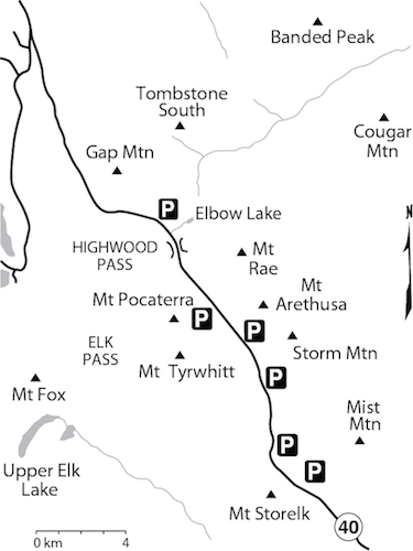
Mount Tyrwhitt 2874 m moderate
Mount Pocaterra 2934 m moderate
Storm Mountain 3092 m moderate
Mount Storelk 2867 m difficult
Mount Rae 3218 m moderate
Mount Arethusa 2912 m difficult
Mist Mountain 3140 m moderate

Peaks in this chapter are found adjacent to a 5 km section of Kananaskis Trail (Highway 40) running southeast from Highwood Pass in Kananaskis Country toward Highwood Junction.
The usual Rockies Front Range topography is evident here: long limestone ridges aligned northwest–southeast. If one looks back millions of years, these limestone peaks were once horizontal layers of differing sediments under a great sea. The sediments had been collecting for perhaps 1.5 billion years. Gradually, two crustal plates collided, and over some 75 million years slowly pushed the sediments up into waves of rock. This is a simple explanation of how the Canadian Rockies were formed. In this area, a noteworthy geological movement called the Lewis Thrust occurred and this event further uplifted and tilted peaks through here. The strata of these peaks have been so tilted by compressional forces that many now stand almost vertical.
With such steeply angled strata, one frequently finds faces that are steep on the west side, sometimes overhanging on the east. Erosion too has played an important role in shaping these peaks. Sometimes, along seemingly plausible routes, pinnacles are encountered, formed as a result of weathering away of softer shales sandwiched between harder rock layers. This can add unexpected challenges to route shortcuts and variations. The ridgelike nature of the ranges, however, often allows relatively straightforward travel along the spine of the uplift once upon it.
The highest peak around Highwood is Mount Rae (3218 m). Mount Rae along with nearby Mount Tyrwhitt see most of the foot traffic. The Highwood area is comparatively dry, although snow tends to linger around Highwood Pass well into July. Underbrush is virtually absent, and given the relatively high roadside elevation, these ascents are tailor-made to our instant-gratification society – quick and rewarding! Similarly, a late September ascent in this area is a real treat, with golden larch trees in abundance. In a dry year, ascents are possible into November, long after the crowds have retreated indoors.
The abundance of small, meadowy alpine valleys and cirques seems to have a definite attraction for grizzly bears, too. Over the years, many have been trapped and collared for research projects. It is not uncommon for hikers to encounter these beasts on occasion, and in fact specific trails may sometimes be closed temporarily by authorities if warranted. Even the visitor driving through in early evening may see a bear wandering and browsing along the roadside. Ptarmigan and Tyrwhitt cirques in particular seem to have a high level of bear appeal. Be sure to make noise as you walk.
Access Highwood Pass is reached through Kananaskis Valley via Kananaskis Trail (Highway 40) starting 65 km west of Calgary. This road continues southeast, to Longview and eventually Highway 2 south of Calgary. Highwood Pass is closed each year from December 1 to June 15 from Peter Lougheed Park to Highwood Junction.
Accommodation Camping is available (if you arrive early!) at Kananaskis Lakes and farther north at Mount Kidd RV Park. Kananaskis Village has several hotels and nearby Ribbon Creek Hostel, while to the east the Longview area offers motels and camping.
K-Country campgrounds 403-591-7226
Mount Kidd RV Park 403-591-7700
Information is available at Kananaskis Visitor Centre in Peter Lougheed Provincial Park. A park ranger is stationed seasonally at Highwood Junction; others are found at Boundary Ranger Station in Kananaskis Valley. RCMP are in Canmore and Turner Valley.
Highwood Junction Info 403-949-4261
Peter Lougheed Info Centre 403-591-6322
K-Country camping 403-591-7226
Backcountry campground permits 403-678-3136
Updated trail info: kananaskisblog.com.
Facilities Limited supplies are available at Boulton Creek near Kananaskis Lakes, at Fortress Junction, Mount Kidd RV Park, Kananaskis Village by Ribbon Creek and at Highwood Junction. Otherwise, visit either Longview or Canmore.
Boulton Creek Trading Post 403-591-7678
Fortress Junction 403-591-7371
Highwood Junction 403-949-4261
Emergency Kananaskis Country Emergency Services can be reached at 403-591-7755. Emergency 911 service is also available through most of K-Country. Specify which area you are in.
RCMP Longview 403-933-7227.
Difficulty: A moderate scree/slab scramble via east side
Round-trip time: 4–7 hours; allow 1–2 hours up from Grizzly Pass
Height gain: 650 m
Maps: 82 J/11 Kananaskis Lakes; Gem Trek Kananaskis Lakes
Mount Tyrwhitt offers an easy approach, an interesting scramble and minimal elevation gain. The starting point in delicate larch meadows is an inspiring beginning. In autumn, brilliant golden larches make the approach especially scenic. This ascent is very popular, and rightly so. The views are nothing short of outstanding. Available options include a return loop or a ridge traverse to a higher, unnamed peak, depending on your energy. Please walk softly through the meadows, as this fragile alpine terrain is easily damaged. Years pass before plant life recovers from big boots, so please stay on existing trails to reduce your impact. Two things are desirable for this ascent: clear weather so you can enjoy the panorama; and a helmet for the steep rubble slope on return. Try from July on.
Drive to Highwood Meadows parking lot at Highwood Pass on Kananaskis Trail (Highway 40). Note: Road closed December 1 to June 15.
From the parking lot, start out on the interpretive trail and head toward the first platform. Just before this path heads right (two minutes maximum), branch left on a much narrower trail (fragile-vegetation sign) and continue. A beaten trail then leads you through forest and up over a ridge before descending to a small pond. Continue on the trail to the open basin of Pocaterra Cirque, the headwaters of Pocaterra Creek’s southwest fork. An obvious path to the left leads up and traverses scree slopes toward Grizzly col, the low saddle on the left (east) side of the objective. The col separates Mount Tyrwhitt from an unnamed point immediately east that is not marked on map 82 J/11. This saddle is an ideal place to pause before trudging up the remaining 250 m to the top.
Grizzly col sits squarely atop the Lewis Thrust, the result of a geological event that pushed massive sheets of older Rundle limestone from the west up over younger and more easily eroded shales and sandstones. Running northwest to southeast, the fault line extends from Glacier Park in the United States north to Mount Kidd. This explains the abrupt transition between gentler shale slopes east of the col to higher-angled grey limestone on Tyrwhitt.
About halfway up, close to the ridge, is the unique 5-m-high window formed by a rock arch. Resembling an inverted wishbone, it nicely frames multi-pinnacled Mount Elpoca to the north. If you look closely, this arch is visible from the highway at a point just northwest of Highwood Pass.
The view from the top is spectacular toward Kananaskis Lakes and Mount Joffre, and you really have to see it for yourself. If you find the outing too short, two extensions are available. You can continue to Mount Pocaterra or, for a longer and more scenic return, traverse the ridge northeast of Grizzly col back to your car. This traverse does involve a fair bit more elevation gain and loss. At one point you may have to descend some distance on the right to get past a steepish, downsloping rock band, then regain much elevation. Farther along, you pass thin coal seams, representative of massive beds to the south in Crowsnest and Elkford. From the last high point above the parking lot, descend north and return to your vehicle.
Sir R.Y. Tyrwhitt was the leader of the British destroyer flotillas during the First World War.
Difficulty: Moderate scrambling with exposure
Round-trip time: Allow 3–4 hours from Mount Tyrwhitt
Maps: 82 J/11 Kananaskis Lakes (unmarked at 395070); Gem Trek Kananaskis Lakes & Region
Mount Pocaterra is an unofficial name for a higher unnamed peak to the north at 395070 that is connected to Tyrwhitt by a spectacular, exposed-looking ridge. Despite its appearance, you can scramble the length of this ridge without great difficulty. It does require quite a loss of elevation to a low point, however, and then you must steadily regain every bit and even more. Once you leave Tyrwhitt, much of the first half or more is easy going along the crest, although the drop on the east is terrific. Only toward the finish does it become a bit more challenging. The few exposed spots can usually be avoided by dropping down on the west side; a towering gendarme also requires scrambling down on the left.
It is also possible to reach the connecting ridge by a fairly direct line up the east face from Pocaterra Cirque. The route can be seen from the road and has a section of difficult scrambling. The second of Pocaterra’s two summits seems to be marginally higher, and whether you use the direct east-face route or traverse from Tyrwhitt, views are fabulous. Returning via the east-face route may entail tricky routefinding if you didn’t ascend that way.
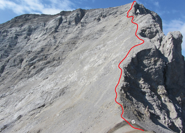
The rubbly ascent route up Mount Tyrwhitt. G: Grizzly col; A: rock arch. PHOTO: DINAH KRUZE
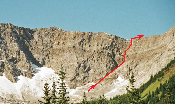
Direct route to Mount Pocaterra connecting ridge as seen from highway. Mount Tyrwhitt is at far left.
Difficulty: Difficult scrambling in places
Round-trip time: 4–6 hours
Height gain: 1050 m
Maps: 82 J/10 Mount Rae; Gem Trek Highwood and Cataract Creek
Storm Mountain is a popular outing with a short, easy approach through larch meadows. A high starting point in the dry eastern Front Ranges eliminates bushwhacking or plodding through forest to attain the summit. Try from July on.
Park at the Lost Lemon Mine information sign, 4.4 km south of the Highwood Meadows parking lot on Kananaskis Trail (Highway 40). Note: Road closed December 1 to June 15.
Two valleys access this peak. The narrower one, 500 m north of the parking area (455045), is where the descent route emerges, but the recommended approach enters the next valley south (460042) and offers the easiest route up. From the highway pull-off by the Lost Lemon Mine sign, simply follow the rubbly drainage (450035). The trail should be above the stream on the left. Then, at the last bit of meadow, ascend the scree slope on your left to the start of the ridge.
From the high point at the south end of the ridge (461052) you should immediately descend to a wide ledge 5 m lower on the east side. This conveniently avoids the narrow, scary crest. Still, this shaded ledge exposes you to an airy drop on the east side, and if snowy, as it sometimes is, this can be serious going. It is best when bone dry. Once you get past the low point, scramble back up to the ridge crest and to the top. There is a fine view to the west of Mount King George (3422 m), the monarch of the Royal Group, and Mount Sir Douglas (3406 m) rising skyward to the northwest.
For a rapid descent I used the west ridge, crossing a tricky but short connecting ridge across a notch. Others have descended from right below the notch, too. The west ridge leads to scree and slabs that take you quickly down to valley meadows. As you exit this valley a good trail heads left, traverses open slopes above treeline back toward the approach valley, then descends to the road. Or else retrace your ascent route.
Geologist Dr. George Dawson, a topographical surveyor and director of the Geological Survey of Canada, named the peak for storm clouds observed on the summit.
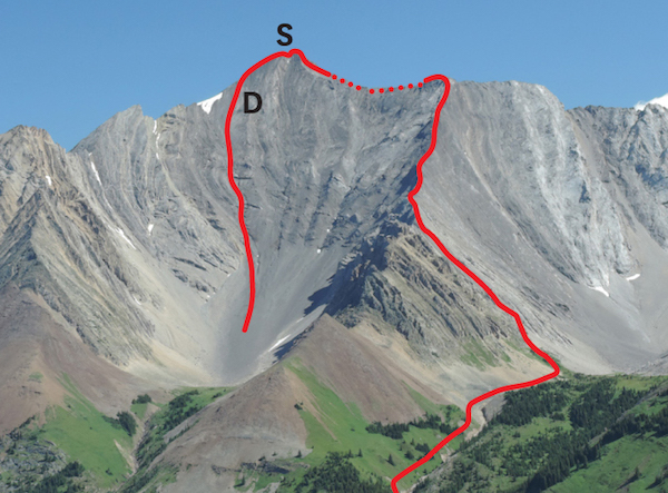
Storm Mountain ascent and descent. The route follows a ledge below the ridge on the east side. S: Storm Mountain; D: descent route.
Difficulty: Difficult scrambling with exposure; routefinding required
Round-trip time: 5–8 hours
Height gain: 915 m
Map: 82 J/10 Mount Rae; Gem Trek Highwood–Cataract Creek, Kananaskis Lakes & Region
Mount Storelk is the next summit south of Mount Tyrwhitt on the long ridge known as the Elk Range. The suggested route involves steep, exposed scrambling, and both your route-finding and route-following skills will determine the degree of challenge presented. Dry conditions are required. A fairly decent trail aids the approach once you’re on it. In autumn, when larches are in their golden splendour, this is a particularly fine outing. This area is favoured by grizzlies – think twice before going alone. Try from July on.
Drive 6.5 km east of Highwood Meadows at Highwood Pass, 750 m past the Mount Lipsett day-use area, and park on the west side of the road (flagging, cairn) at 448015. The peak and much of the route are visible at km 5.5. Note: Highwood Pass is closed from December 1 to June 15.
Below and east of Storelk’s summit lies a small basin or cirque cradled between two east-trending ridges. An obvious drainage empties this cirque toward unseen Storm Creek. The right-hand one of these two ridges rises directly to the summit but is too steep to scramble. Fortunately the left-hand ridge on the south side of the basin reclines at a more reasonable angle. The objective is to hike into the basin, turn left to gain the saddle, then scramble along the south-facing flanks (back side) of this easier ridge to the main spine of the peak. You do not ascend the actual ridge crest until near the top.
Head off into the trees on a trail. Within minutes pass to the right of a small pond and in about 300 m come to a T-junction at 446014. Turn left. The trail rises slightly, then drops to cross Storm Creek. Steep, eroded banks may require some searching for a crossing. At the top of the opposite bank, turn sharp right. Steer northwest on a blazed and flagged trail above the west bank of Storm Creek. Just before the drainage from Storelk basin meets Storm Creek, turn left on a game trail and continue toward the aforementioned basin. A treed ridge that rises to the left and encircles the basin also leads to the ascent route but gains unnecessary elevation. The most direct route to Storelk’s ascent ridge lies at the far (southwest) end of the basin, up a brown gully of shale debris which in 2013 washed right down into larch forest. Meadows and berry bushes through here make this prime grizzly habitat – don’t be afraid to yell.
Lush slopes at the saddle are ideal for studying the terrain ahead. The ascent route avoids the unfriendly ridge crest, a point not emphasized in earlier guidebook editions. Stay well to the left of the ridge and, about halfway up, angle right to scramble the first weakness (narrow gully) immediately left of the ridge.
Hike up the green belt between the ridge and the long scree slope to its left. At the steep rock, traverse left on rubble until able to comfortably scramble up. It gets easier the farther left you go. Once on the rock, angle up to the right on slabs and rubble, aiming for the first gully left of the ridge. This is not entirely obvious from below. You should watch for a few dark pockets in the rock as you scramble up this crux section. These confirm that you are heading up the least steep way. You ascend about parallel to the ridge, detouring trickier parts left or right as required. Note your route for descent as you go. Beyond this, the gully angles right to gain easier rock strewn with rubble. Continue in the same direction and finally, for the last stretch, ascend the ridge.
A fabulous, far-reaching view across Elk Valley unfurls. Turn right and scramble the undulating ridge to the summit, 30 minutes north. Once the too-firm furniture makes you fidget, leave the summit and return the same way.
The mountain sits between Storm Creek and Elk River, hence, Storelk.
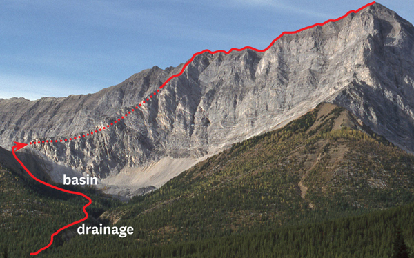
Mount Storelk as seen from the road. From the saddle the route stays below the ridge on the opposite side, indicated by the dotted line.
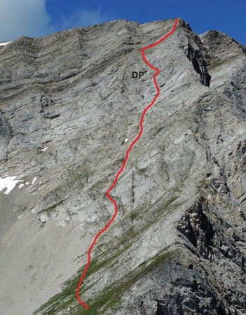
Close-up of east ridge route from high point east of saddle. Route stays well left of ridge crest until near top and is not as steep as it appears. Line shown is approximate. Note the DP dark pockets in rock.
Difficulty: A moderate scramble via south slopes and ridge
Round-trip time: 5–9 hours
Height gain: 1030 m
Maps: 82 J/10 Mount Rae; Gem Trek Kananaskis Lakes
The foreshortened roadside view of Mount Rae renders it neither striking nor beautiful. Nonetheless, at 3218 m, it is one of the highest peaks in either the Front Ranges or the Kananaskis region. Combined with the easy approach, its height guarantees its popularity regardless of the scree involved. Narrow sections of the ridge from the col to the summit are dangerous if snow remains, and accidents have occurred in the past. Carry an ice axe; try from about July on. Note: Gaining the once popular SSE Ridge (King’s Ridge) from the cirque’s back right corner has become more difficult owing to exposed slabs.
Drive to Highwood Meadows parking lot at Highwood Pass on Kananaskis Trail (Highway 40). Note: Road closed December 1 to June 15.
Cross the road and follow Ptarmigan Cirque trail. This popular little hike leads quickly past alpine meadows to Mount Rae’s normal route. At the back of the cirque, follow the trail left and trudge up rubble toward the col between Mount Rae and the 3018 m outlier to the west (428089). Heavy rains removed much debris here during 2013 and the rock ribs left protruding make for better scrambling now than they did before. As you top out, the view to the north bursts forth, and here you’ll probably be about ready to have a snack and ponder the upcoming section. A minuscule glacier directly below you is the ultimate source of the Elbow River and Calgary’s drinking water – mind where you pee! In years when snow falls before the road closes for the winter, this secluded pocket of ice is popular with eager telemarkers. The sheltered north aspect holds snow well.
As you continue up the ridge, small gendarmes (pinnacles) can be easily skirted until a threateningly large one, which looks like it might even be the summit, straddles the entire crest. If there is snow on the north-facing slopes to the left of this pinnacle, it is possible to circle around to the right to get up it. Climb a small slab into a chimney beneath a monstrous chockstone. In dry conditions the logical way is to detour left onto scree and ledges high above the glacier and regain the ridge farther along. Otherwise, the next gendarme on the ridge crest will need some awkward moves. You can avoid most obstacles, including the narrow summit ridge, by keeping left.
The view from the top is impressive and encompasses both prairie to the east and many recognizable peaks to the north, west and south. On return, obvious beaten paths avoid the ridge entirely.
James Hector, surgeon and geologist of the Palliser Expedition, named Mount Rae for fellow surgeon John Rae. Rae was, among other postings, a doctor on a Hudson’s Bay Company ship and also helped in the search for the lost Franklin Expedition.
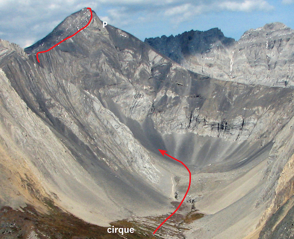
Mount Rae as seen from Tyrwhitt. P: pinnacle. PHOTO: BOB SPIRKO
Difficulty: Difficult scrambling via south slopes and southeast ridge
Round-trip time: 3–5 hours
Height gain: 750 m
Map: 82 J/10 Mount Rae; Gem Trek Kananaskis Lakes & Region
Mount Arethusa is a short but exciting scramble in the scenic Highwood Pass area. The ridge-like shape of this peak does not suggest any great challenge, but the route is exposed in several places and requires dry conditions. It is therefore rated “difficult” compared with the “moderate” grading given for neighbouring Storm Mountain and Mount Rae. Like adjacent peaks, though, the high starting elevation makes for an easy approach and a short day. The optional descent route saves time if dry, but it is challenging and steep. Try from July on.
Park 1.3 km south of the Highwood (Pass) Meadows parking lot on Kananaskis Trail (Highway 40). Note: Road closed December 1 to June 15.
From the parking area it is possible to follow up either side of the creek initially, though you may find a cairn on the right-hand side. Wasting no time, this quick approach soon leads to alpine meadows of the upper valley, with Arethusa’s summit lying directly north. Toward the south end of the peak are several places where the horizontal cliff band has eroded away and you can gain the ridge crest without any problem. From there, continue north along this interesting crest, making short detours as required until you reach a point where you must descend a step in the ridge. This bit is the crux and needs to be snow-free.
If all the snow is gone, the west ridge offers a quick but steep and committing descent route involving a narrow gully, loose rock, a chockstone and slabs. This is only feasible when it is free of snow and dry and is still at least as demanding as the crux along the ridge. You should check the condition of the gullies where this optional descent lies as you approach treeline, as they cannot be seen from the summit. Note that even in mid-July the gully may harbour snow. From the summit, traverse ledges and short slabs diagonally for about 50 m to an obvious deep notch which can be seen from the highway. A steep, narrow, curving gully leads back left (south) to open meadows and your approach route. This descent demands a helmet, and with snow present it is not a scramble; it is alpine climbing and might even require a rappel. Loose rock is abundant, so this confined chute is not a logical descent route for groups. Stemming and chimneying moves are the normal techniques for descent. It may actually serve better as an ascent route but at the time of writing I am not aware of anyone having done it.
Arethusa, a woodland nymph in Greek mythology, was changed into a stream to escape her pursuers. In yet another surprising but more recent metamorphosis, she became a warship – a British light cruiser, to be exact. Her final transfiguration occurred when she was sunk by a mine in 1916. She has been sorely mythed ever since.
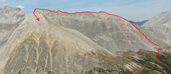
Mount Arethusa ascent route seen from Highwood Ridge. The route gains the ridge at the right-hand end near a low point, then follows close to the crest. The summit lies at the left end. PHOTO: BOB SPIRKO
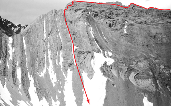
Close-up view of Mount Arethusa. C: crux; D: descent. PHOTO: GILLEAN DAFFERN
Difficulty: Moderate scrambling by northwest ridge, with brief exposure; more difficult from Mount Lipsett col
Round-trip time: 7–10 hours
Height gain: 1110 m
Maps: 82 J/10 Mount Rae (Mount Lipsett unmarked at 470013); Gem Trek Highwood and Cataract Creek
Although overshadowed by nearby Mount Rae, Mist Mountain is still one of the loftier viewpoints in Kananaskis. Located alongside Kananaskis Trail in the dry Highwood Pass area, it readily lends itself to a traverse. The most direct approach is from the north end and uses broad gullies to gain the northwest ridge. Try this ascent from July on.
Park at the Lost Lemon Mine information sign, 4.4 km south of the Highwood Pass Meadows parking lot on Kananaskis Trail (Highway 40). Note: Road closed December 1 to June 15.
From the parking area, cross the road and hike a trail to the left of stream debris (451028) to the first open green slope on the left. Ascend this slope, angling right to get into the ascent gully. When this gully splits higher up at the band of light-brown rock, follow the right-hand branch to the ridge. Like so many others, these gullies had a darn good rain-scouring in June 2013. Debris blocked the highway for an entire season. Most of the elevation gain occurs in reaching the northwest ridge. From there it is preferable to tramp beside the crest rather than tiptoe along it. Expect an exposed bit near the top. On the summit is a plaque in memory of a local scrambler killed by lightning.
An ascent from the col between Mist Mountain and Mount Lipsett offers more challenge, particularly if you choose to scramble up ridges and ribs instead of toiling up rubbly gullies.
To reach Lipsett col, follow the stream as described earlier, but continue rightward to the headwaters and then scramble up wherever you like to the col between Mist and Lipsett. You could also hike straight up steep, open slopes above the road to Mount Lipsett, but this would involve extra gain and loss of elevation. From the Lipsett col there are many ways to gain the south ridge of Mist Mountain. Some rock ribs and pinnacles overhang on east-facing aspects and may require some backtracking, other sections are surprisingly firm and offer delightful scrambling. It is short-lived, though, and quality quickly deteriorates as you reach the southeast ridge. Loose, frustrating scree concludes the ascent. Lacking a paddle, ski poles are probably best for this tedious terrain. You can combine these two different routes to do a high-level traverse while bagging unobtrusive Mount Lipsett (2482 m) as well.
Mist Mountain was named by geologist George M. Dawson during the same spell of weather that inspired nearby Storm Mountain’s name. There is a small, infrequently visited hot spring situated well above treeline on the east side of Mist, but it is unlikely to produce any more than very localized mist.
Mount Lipsett is named after Major General L.J. Lipsett, CMG, who served with the Canadian Expeditionary Force in the First World War.
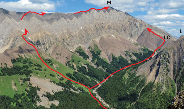
Mist Mountain as seen from Highwood Ridge. The two routes can be combined for a traverse, visiting Lipsett col first. M: Mist Mountain; LC: Lipsett col; L: Mount Lipsett.