Ptarmigan Peak 3059 m moderate
Mount Richardson 3086 m moderate
Skoki Mountain 2697 m easy
Pika Peak 3033 m difficult
Fossil Mountain 2946 m easy
Oyster Peak 2777 m moderate
Mount Redoubt 2902 m difficult
Brachiopod Mountain 2650 m easy
Anthozoan Mountain 2695 m easy
Lipalian Mountain 2710 m easy
Unity Peak 2696 m moderate

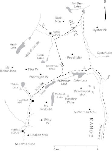
As a backcountry base for scrambling, few locations can match Skoki. It is truly paradise. Ascents are many and the surroundings are nothing short of spectacular. Starting elevations are high, so you need not worry about bushwhacking, while an established network of trails makes for easy approaches. You could spend an entire week here and bag a new peak each day! By Rockies standards, rock quality in the area is acceptable and few ascents involve any steep or difficult scrambling. In the past the only deterrent was an unavoidable 4 km trudge up Temple Road to the trailhead. Now, since adopting recommendations of the Bow Valley Study in 1997, Parks Canada has a quota system that restricts the number of visitors to the area. Check with the information centre in Lake Louise. Bikes are allowed as far as Temple Lodge (4 km).
Although the access road may be a less than aesthetic start to your visit, it is not without merit. Almost 100 years ago one perceptive visitor noted, “Looking back, the view of Mount Temple, Paradise Valley and the Ten Peaks is a wonder, and you realize that in order to see these mountains you must really cross the Bow Valley and climb up on the other side.” This “other side” just happens to be the route into Skoki.
Skoki Valley has long been popular with backcountry skiers, horse riders and fisher folk. Hikers, backpackers and peakbaggers are relatively recent appearances, especially the latter.
Skoki Lodge even played host to the royal couple William and Kate in July 2011. During his training in the area with the British Army earlier, Prince William had slept in a snow cave at one point but reportedly wished he had been in cozy Skoki Lodge instead. Years later their honeymoon visit to Canada finally provided him that opportunity. No more snow cave!
The area retains a distinctly wild nature, despite its long-standing popularity. Lodge staff have witnessed wolves passing through, and fishers have glimpsed wolverine, a small, vicious creature known for its ferocity. The high meadows and open slopes of nearby Lake Louise ski area attract grizzlies. Our group once experienced the unforgettable sight of a sow grizzly gambolling with four tiny cubs across the meadows at Baker Lake. The previous evening, an inquisitive young grizzly wandered into camp at dinnertime, convincing us to scurry over to a nearby shack, Halfway Hut, rather than sleep in our flimsy tent. Park officials were quick to close the area until the bears moved on, a situation that has since been repeated. Take all bear precautions when in this area. See the “Hazards” section at the start of this book.
Skoki Lodge’s location was chosen because it promised the reliable, deep snow needed for a backcountry ski lodge. Consequently, scrambles do not get into condition until the snow melts about July or later and the season usually winds down about late September.
Backcountry camping permits and a backcountry pass must be obtained from the Parks Canada Information Centre in Lake Louise by Samson Mall.
Access From the overpass at the Lake Louise townsite on the Trans-Canada Highway, drive 1.6 km toward the Lake Louise ski area. Turn right onto the Temple Lodge access road and continue for 1 km to the Fish Creek parking lot on the right side of the road before the gate. Park here.
Hike or bike the gravel access road 4 km toward Temple Lodge, which is located 100 m downhill of the road. The road ends at the edge of the ski run above the lodge, near a wooden building that formerly housed a Parks Canada avalanche research station. Ascend the ski run 200 m to the start of the well-used and signed trail. Hidden Lake campsite is located a few minutes’ walk north of Halfway Hut (closed to overnight visitors) about 4 km from Temple Lodge. To reach Baker Lake campground, continue over Boulder Pass and along the left (north) shore of Ptarmigan Lake to the east end of Baker Lake. For Skoki Lodge and the backcountry campsite, turn left from the east end of Ptarmigan Lake and hike the trail over Deception Pass and down into Skoki Valley.
Accommodation If you’re planning on spending time in the area, Hidden Lake campsite is ideal for ascents of Richardson, Pika, Ptarmigan, Fossil, Redoubt and Heather Ridge. Baker Lake is closer for ascending Oyster, Anthozoan or Brachiopod peaks. Skoki Lodge is a rustic backcountry chalet beside Skoki Mountain. It caters mainly to horse-riding groups in summer but will usually sell snacks to non-guests. The backcountry campsite is 1 km north of the lodge.
Difficulty: A moderate scramble via south scree slopes
Round-trip time: 4–7 hours from Hidden Lake
Height gain: 780 m
Maps: 82 N/8 Lake Louise; Gem Trek Lake Louise–Yoho
Occasionally, when avalanche conditions are stable, ski parties ascend this peak, and in the past it has also been popular with British Army mountain training units. Near the top, a short, mildly exposed dip in the ridge adds variety.
From Hidden Lake, gain the broad south slopes slightly west of Boulder Pass. If you stay more to the left of the wide rubble slope, you’ll have more scrambling and less scree plodding. Just before the highest point at the east end, the ridge dips and narrows for 5 m directly above a long, narrow gully cleaving the south side. To this point the way is easy and the problems few. This brief section is only of moderate challenge but does interrupt the simplicity of the ascent momentarily. Crossing this arête exposes you to a terrific drop on the north side.
Occasionally, when avalanche conditions are favourable, ski parties ascend this peak, but judging by entries in the register, lads of the British Army mountain training units seem to make up a larger number of visitors.
Once you’re on top, Mount Hector commands the northerly vista. When viewed from easterly and southerly directions such as when you drive west toward Lake Louise, many people have noticed an apparent resemblance between Mount Hector’s outline and the once popular cartoon dog “Snoopy” in his familiar supine position atop his dog house. Return the same way.
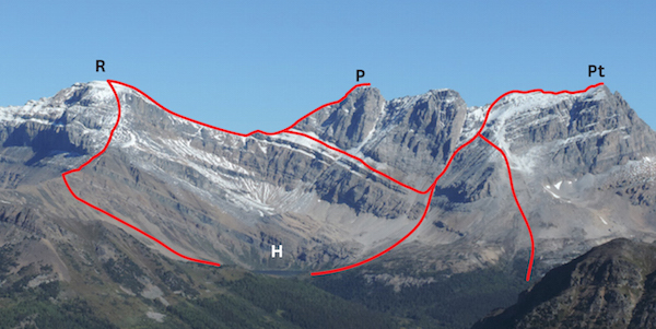
Popular scramble routes for R: Mount Richardson; P: Pika Peak; Pt: Ptarmigan Peak, as seen from Lipalian Mountain. H: Hidden Lake is the starting point.
Difficulty: Easy/moderate scramble via scree on south aspect
Round-trip time: 3.5–6 hours from Hidden Lake
Height gain: 800 m
Map: 82 N/8 Lake Louise; Gem Trek Lake Louise–Yoho
Mount Richardson is the highest peak in the Skoki area and is an enjoyable scramble with an option to traverse and descend by a different route. If camping at Hidden Lake, the mountain is right outside your tent flap. Map editions as late as 1980 erroneously indicate massive glaciation covering most of the peak and extending east to Pika and Ptarmigan Peak, but this is simply not so. An ice axe is recommended for the traverse toward Pika Peak. Try from July on.
The south ridge above Hidden Lake is the easiest way to this expansive summit. Although the summit ridge isn’t particularly narrow, be aware of cornices and a steep glacier on the north side. You can also reach the top after scrambling to the col between Richardson and Pika, although the slope above the col is often snowy and may require step-kicking and an ice axe. This route also serves well for descending and can be used to complete a traverse. The summit gives a terrific view of Mount Hector, the big peak to the north, and all the giants surrounding Moraine Lake and Lake Louise.
If you’re really keen, a traverse of Mount Richardson can be extended to an ascent of Pika Peak via the west ridge. This is a worthwhile and recommended day trip from the campsite. Note that the ascent of Pika is a difficult scramble compared to the easy trudge up Mount Richardson.
Sir John Richardson was surgeon and naturalist on the Franklin Arctic expeditions.
Difficulty: An easy ascent via north scree slopes
Round-trip time: 2–4 hours from Skoki Lodge; day trip from Hidden Lake
Height gain: 530 m from Skoki Lodge; 735 m from Hidden Lake
Maps: 82 N/9 Hector Lake; Gem Trek Lake Louise–Yoho
Skoki Mountain is a quick little ascent right behind Skoki Lodge. This diminutive mountain has been ascended via some nine different routes by Edwin Knox, a former employee of historic Skoki Lodge. It is not a complex peak. The most common way follows an old logging road, now a wide swath, hacked into dense forest. Try from July on.
The most sensible starting point for this outing is the backcountry campsite 1 km north of Skoki Lodge. If you are camping at Hidden Lake, the approach hike will be much longer. During the 8 km approach, you must gain some 200 m elevation to cross Deception Pass, then promptly lose all of it and more before reaching Skoki Lodge and the base of the peak. This modest summit hardly justifies such a long-winded march, despite fine scenery en route.
Begin immediately back of the lodge near the present site of the outhouse. After rising through forest, the path leads to open meadows at treeline on the north side, and then a scree plod up open slopes takes you to the top. Expect confusion if the outhouse is moved.
An early visitor to the region hailed from Skokie, Illinois, a suburb of Chicago; also, Skoki is purported to be an Indian word meaning “marsh” or “swamp,” some of which lies in areas to the east.
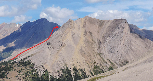
From Skoki Lodge, easy slopes lead up Skoki Mountain. The route goes around to the north side near the summit.
Difficulty: Difficult scrambling via Richardson/Pika col and west ridge
Round-trip time: 3.5–6 hours from Hidden Lake
Height gain: 750 m
Maps: 82 N/8 Lake Louise; Gem Trek Lake Louise–Yoho
Although it is a grade or two more difficult than nearby Mount Richardson, Pika is a delightful scramble once the snow has gone and the rock is dry. As noted by mountaineers Delafield and Earle in 1911, “This (westerly) arête, which at a distance looks difficult, and which in fact is steep, is composed of rocks so broken as to render the ascent quite easy.”
Gain the Richardson–Pika col via either Pika’s lower, rubbly flanks above Hidden Lake or by traversing from nearby Richardson. The ridge to the summit consists of several short, steep steps, sometimes cleft by short chimneys that make the ascent easier. The rock is excellent – firm and rough-textured. Stick close to the crest and avoid straying around to the exposed north side, as it drops abruptly to a pocket glacier below.
Protruding like a stony fin just north of Pika Peak is an impressive freestanding wall of rock known as the Wall of Jericho. Ken Jones, guide and one-time manager of Skoki Lodge, ascended one of the two high points decades ago.
Although I don’t recall seeing it, Pika Peak is apparently named for a rock formation near the top that resembles a mountain pika, or “rock rabbit.”
Difficulty: An easy ascent from Deception Pass
Round-trip time: 4–6 hours from Hidden Lake
Height gain: 670 m
Maps: 82 N/8 Lake Louise; Gem Trek Lake Louise–Yoho
This ascent is nothing more than a walk up a scree slope, and because it is so easy, backcountry skiers occasionally go up this peak in winter, too. The view of the surroundings is spectacular.
From Deception Pass, tramp up the windblown west slope, usually bare even in the depth of winter. Coral fossils litter the route and add interest to an otherwise mundane march. The trek is far from boring, though: picture-perfect Skoki Lakes, cerulean jewels snugly nestled between Ptarmigan Peak and the Wall of Jericho, are in themselves reward enough. When a group of American mountaineers saw these lakes in 1911, they named the lower one Myosotis, “not only on account of its colour, but also on account of its forget-me-not qualities.” To the south, beyond the ski area, are the dazzling big peaks like Victoria and Temple that lure so many visitors to Lake Louise and Moraine Lake.
On descent you may be able to glissade the broad southwest gully toward Deception Pass if you have an ice axe. Steer clear of this slope in winter – wind-loading creates soft-slab avalanche conditions, which resulted in two fatalities in the winter of 1988. A memorial plaque on top recalls this tragedy. For many years this beautiful plaque was marred by graffiti but in 2012 it was restored.
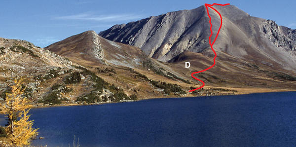
Fossil Mountain and Ptarmigan Lake from Boulder Pass. D: Deception Pass.
Difficulty: A moderate scramble via west-facing slopes
Round-trip time: 3–5 hours (south summit only) from Baker Lake
Height gain: 600 m
Maps: 82 N/9 Hector Lake; Gem Trek Lake Louise–Yoho
Oyster Peak affords good scrambling to the south summit and along the ridge to the north end. The view of the Pipestone and Red Deer valleys is excellent, and you probably won’t find other parties on top. Try from July on.
From Baker Lake campsite, stroll across Baker Creek valley and ascend straightforward rubble slopes at the south end. Continue easily along the broad crest for an hour to the true summit at the north end, which is about 40 m higher. Rather than backtrack the entire ridge from North Peak some parties downclimb slabs and descend rubble westward to Baker Creek valley. Watch closely for a cairned route. The nature of the terrain allows much scope for variation on both ascent and descent.
The tiny lake below the north end was at one time known as “Hatchet Lake,” a name that has since been lost to time. Don’t axe me why. The discovery of large quantities of fossils similar to common oysters induced geologist G.M. Dawson to title this peak accordingly. It is likely they were brachiopods, which you may also notice on your ascent.
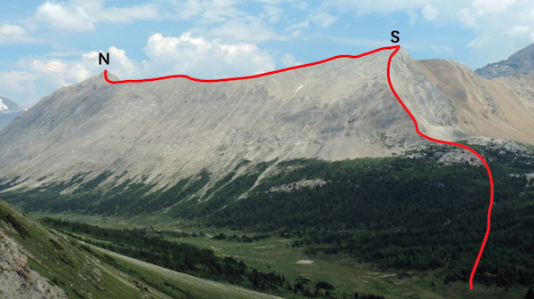
Oyster Peak looks more like a ridge than a peak. It is readily ascended from Baker Creek Valley.
N: north; S: south.
Difficulty: Moderate to difficult scrambling via northwest ridge
Round-trip time: 5–8 hours from Hidden Lake
Height gain: 475 m (approximately) with loss and regain
Maps: 82 N/8 Lake Louise; Gem Trek Map Lake Louise–Yoho
The northwest ridge of Mount Redoubt grants good scrambling in grand surroundings. As usual, though, a certain amount of scree-bashing is involved. The view toward Mount Temple is stunning. Try from mid-July on.
From Hidden Lake, head up over Boulder Pass and along the south shore of Ptarmigan Lake. Hike south up to Redoubt Lake, then easily gain height up over the north ridge of the objective. You must lose 120 m elevation and cross a small, rubble-strewn (not glaciated as some maps show) basin en route to the northwest ridge. This roundabout route is not problematic, but it sounds more confusing than it actually is. Once you’re on the northwest ridge the scrambling is delightful, with many horizontal ledges and big, firm handholds. The backdrop is a signature of Lake Louise, revealing giants like Victoria, Lefroy and Temple, three of the 54 Rockies peaks exceeding 3353 m (11,000 ft.). Overcome the final short cliff below the summit plateau by surmounting it on the right. Return the same way. Note: Bob Spirko used a more direct route on the west side which has gained favour of late and can be found online, but I do not have first-hand info at time of writing.
A.O. Wheeler, founding member and president of the Alpine Club of Canada, fancied the mountain resembled a military formation known as a redoubt. In this formation, forces are drawn up in a tight cluster, and this is often a last stand attempt, with no flanking defences.
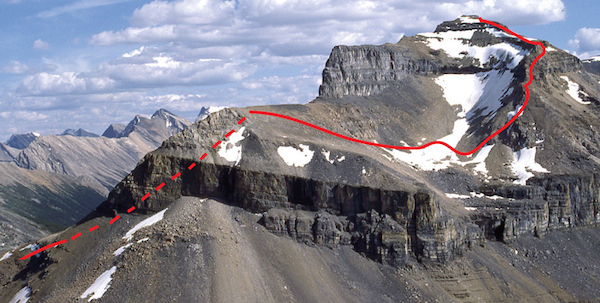
The north side of Mount Redoubt and route from Redoubt Lake.
Difficulty: Easy to moderate via the west slopes
Round-trip time: 3–6 hours from Baker Lake
Height gain: 410 m
Maps: 82 N/8 Lake Louise; Gem Trek Lake Louise–Yoho
Neither of these objectives poses any difficulty, and each is readily ascended by west-facing scree slopes. With a camp at Baker Lake, both can be done in one day and you’ll be back in time for dinner. Each of these summits is a good argument for use of ski poles because of the looseness of the terrain. Try from July on.
From Baker Lake campsite, ford the outlet stream to approach these peaks. If you’re starting from Hidden Lake, either cross the meadows between Ptarmigan and Baker lakes or follow around the south shore of Ptarmigan Lake from Boulder Pass. Clamber up talus on the west slope of whichever one you have chosen. At the top of Brachiopod, a short stretch of slab provides the only bit of challenge, whereas on Anthozoan, partway along the ridge you either cross or detour below a steepish friction slab. If you’re interested, nearby Heather Ridge to the west is an equally simple outing via the west slopes.
Brachiopods are a common fossil found hereabouts; anthozoans are a particular class of fossil. The Mount Brachiopod first-ascent party in 1911 found “five species of coral, three varieties of Brachiopods, a sponge and several other fossils such as Crinoids, Bryozoa etc.” This proliferation of fossils is an intriguing aspect of the Southesk Formation – 370-million-year-old rock that comprises most of the west face.
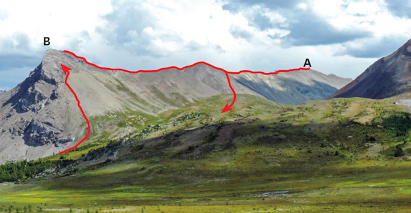
Easy slopes of B: Brachiopod and A: Anthozoan from Deception Pass.
Difficulty: Easy
Round-trip time: 5–7 hours; 1–2 more if including Unity Peak
Height gain: 1000 m; add about 200 m if including Unity Peak
Maps: 82 N/8 Lake Louise; Gem Trek Map Lake Louise–Yoho
Lipalian Mountain overlooks Lake Louise and is easily reached from Temple Lodge access road at the Lake Louise ski area. The ascent involves little more than hiking up a ski run and then tramping up a stretch of rubble to the summit ridge. Views are expansive, and despite being in the midst of a popular ski resort, the beautiful alpine surroundings in larch forest still make for a pleasant ascent. The trip is especially rewarding in late September when mountainsides of larches show their full golden splendour. An optional traverse to nearby Unity Peak makes for a longer, more interesting loop. As with adjacent ascents at Skoki, try from July on.
Drive to the Fish Creek parking lot at the Lake Louise ski resort as for other Skoki area scrambles.
Bike or hike the 4 km Temple Lodge access road until close to Temple Lodge. Any of the ski runs on the right that you encounter before the lodge will lead you to the Larch chairlift upper station on Lipalian Mountain. This includes the very first ski run on the right at 613997, about 45–55 minutes’ walk from the Fish Creek parking lot. As you traipse up the ski run be sure to make plenty of noise. A number of female grizzlies make these slopes their summer pasture and if they hear voices, they will often move away without your even seeing them. Otherwise, the real and dangerous possibility of surprising a bear exists. Carry bear spray if you have presence of mind to use it effectively if a bear charges. Above the lift terminal you may encounter bighorn sheep, but sheep spray is unnecessary. Worst case, they moon you.
The rubble slopes of Lipalian Mountain start just past the upper lift terminal, and you’ve already gained most of the elevation at this point. Follow a gentle draw leading towards the ski area boundary, which is marked by a line of steel poles rising up the lower slope of Lipalian. There are innumerable ways up. I simply hiked alongside this line of poles and in no time I was enjoying stunning views of nearby big peaks like glacier-draped mounts Lefroy and Victoria. When the terrain flattens briefly, angle slightly left to walk or scramble over lichen-clad rubble to the final slope of splintered shale and the broad summit ridge. In winter, skiers and snowboarders tramp up this slope for an ungroomed ride. The slope eases to a rounded ridge with unobstructed views for the remaining walk to the summit.
A ski route known as the Pumpkin Traverse follows the rounded ridge that diverges left (northeast) just before Lipalian’s summit and connects northward to the obvious rounded bump of purple shale. Scramblers can follow the ridge farther to reach Unity Peak at 642994. At one time this route was being used as a training exercise for park wardens, each clad in official orange Parks Canada jackets, hence the name Pumpkin Traverse. You bypass the rotten, teetering gendarme around the right-hand side, just as the bighorns do. Upon reaching Unity Peak, go to the right of the steep buttress and angle up diagonally, scrambling over huge quartzite blocks and ledges. Much variation is possible; I ascended immediately right alongside the buttress, over large, somewhat precarious blocks, but less-steep terrain can be found by traversing farther along the base of the steep rock band. Expect moderate scrambling unless you’re feeling adventurous or are seriously off route.
The summit of Unity Peak is unusual, as it is not one obvious high point but rather a jumble of massive quartzite boulders. A large commemorative plaque prominently mounted on one such boulder explains the naming. On return, descend the ridge northwest toward Mount Redoubt but only to where it widens near a low point. I chose to turn left and easily descend the third gully along at 638000. Wonderful fine-shale slopes grant a quick descent to spongy meadows, flowers and bubbling trickles in the valley. Wander northwest, gaining a good trail left of the stream to intersect the Skoki to Boulder Pass trail not far beyond Temple Lodge. Here you turn left to tramp back to the parking lot.
Lipalian is a geological term which attempts to explain an unconformity between Precambrian and Cambrian strata of rock. This mountain is composed of the youngest Precambrian layers in North America, a period just prior to the sudden appearance of abundant life forms on earth. Records of these various life forms are often found in Cambrian rock. So, simply put, don’t expect to see interesting fossils on this peak. The rock is too old.
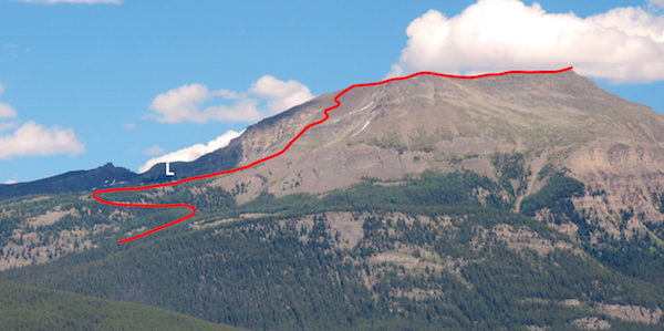
Lipalian Mountain as seen from the Trans-Canada Highway, west of Lake Louise. The route ascends a ski run to its upper lift station (L) and follows rubble to summit ridge. Unity Peak is at far left.
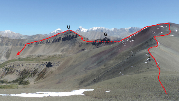
Pumpkin Traverse route from Lipalian Mountain to Unity Peak. G: gendarme; U: Unity Peak. The large purple hump is known as Purple Peak. Mounts Douglas and Saint Bride are behind, to left and right, respectively, of Unity Peak.