
For those who want to live comfortably, in style, and amidst the green.
—May 2015 ad for housing in the Grorud Valley
The term suburbia is not specific. Suburban forms, both within countries and around the world, are highly divergent due to cultural planning norms, ideal ways of living, and especially topographical specificities. Norway’s suburban areas are remarkably distinct. In Norway, the city and suburbia are clearly separated. Generally, cities are nestled between hills and mountains on one side and the sea on the other. As a result, areas for city expansion are limited. Thus, Norwegian suburbia involves a spatial leap, unfolding in pockets of farmland. As a result, suburbs in Norway often function as satellite towns. In fact, some claim that the satellite town was introduced as a conscious rejection of the existing development of private houses and cottage-like settlements found many places in Oslo before World War II. They were designed to provide an efficient solution to the housing shortage after the war and also to nurture communitarian qualities.1 Norwegian suburbs are also distinct in how their design reflects traditional Norwegian housing and living ideals involving space, nature, recreation, and privacy.
The Grorud Valley is an important case study showing the distinctive features of Norwegian suburbia and the relationship between development and nature. The Grorud Valley is the general name for Oslo’s northeastern area and comprises four parts that include housing, industrial areas, and remnants of old farms. About one-fifth of Oslo’s total population lives in this valley, 138,224 people.2 It is the largest suburban area in Norway at almost 14 square miles (36 square kilometers), a quarter of Oslo’s total area. It is nestled in a wide valley, bounded by the publicly owned forest surrounding Oslo, called the “Marka” (meaning “the field” in Norwegian). The boundary of the Oslo Marka was drawn in 1934 following the datum line 220, which marked the limit for how high one could bring water without introducing any artificial mains pressure.
The distinct suburban form of the Grorud Valley is the result of the geological forming of the land, ancient farmland ambits, and planning and housing policies and ideals. First, we review some of the forces that have physically and culturally shaped the valley. We then discuss to what degree the valley’s shaping forces are still in operation and what role they play as the valley faces radically different conditions for growth. The valley is not only an area for growth but also a specific geographical site faced with a growing global population, on the one hand, and increasing market interests, on the other hand. Its physical form, molded by geography and external forces, has a unique texture and grain, unlike any other suburban place in the country or even the world.
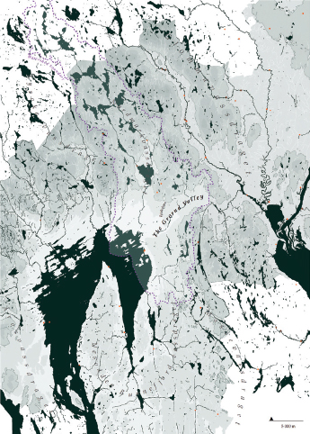
Geological features and the shaping forces of the Ice Ages have determined the topography and land resources of Norway. In turn, these features have influenced the location of suburbs. The expanse of mountainous areas is vast, while the valleys, inlets, and fjords were carved out by ice erosion. (fig. 1.11.1) The narrow strips of inhabitable seashore emerged only after the ice started to withdraw twenty thousand years ago and the land rose subsequently. It is in these areas that cities were founded. Meanwhile, the areas available for farming have been small and scattered, except in a few wider valleys. Wider agricultural valleys are largely made up of fertile till and silt from moraines and rivers. It is in these valleys (like the Grorud Valley, shaped by the oldest landslide known in Norway eight thousand years ago) that we usually find suburban development. They occupy small areas of flat terrain and the forested foothills surrounding them, never far from expanses of mountain and larger forest areas.
In the Grorud Valley, the shaping forces are evident; some of the eighteenth- and nineteenth-century granite quarries are still operating, but more important, property lines still follow the ancient divisions of former farmland, some of it cleared between 1050 and 1350.3 (There are even traces of Stone Age clearings, dating back to 3000 BCE.) The very names of the different “farms” in the valley, which are also the names of the twelve present satellite towns, testify to the centuries-old origins of some properties in the valley.4 When urbanization started in the 1950s, some forty farms were still in operation in an area then easily characterized as countryside.
As a consequence of geomorphology, the Grorud Valley is marked by spatial fragmentation, creating a mosaic of land use: the subdivision of earlier farmland and older mining infrastructure, green areas, and lastly an urban fabric comprising satellite town models, housing in-fills, and pieces of new residential districts. Moraines, rivers, and transportation lines—all of which contribute to a surprising juxtaposition of different land use typologies within a quite limited area—also cut through it. Yet due to the valley’s relative narrowness, it allows for an extreme closeness to the surrounding preserved forests, which play an important role in Norwegian culture.
Traditionally, Norwegians take peculiar interest in their proximity to natural areas. We appreciate the possibility of easy access to mountain and forest areas, and skiing is a priority for a large percentage of the population. Sundays have historically been the day that families spent trekking, berry picking, hunting, and fishing in forests, mountains, lakes, and rivers. The development of satellite towns represented a welcome opportunity to accommodate access to nature and to connect with the postwar effort to build an extensive network of walking and skiing paths in the Marka. The appreciation of access to nature, natural views, and privacy in a home is inherent to Norwegian ideals for the residential environment.
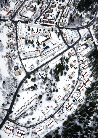
Built in the 1950s, the layout of Lambertseter—the first satellite town in the south of Oslo—demonstrates some of the trademarks of satellite towns around Oslo; an effort to provide direct access to nature and the healthy attributes of air, light, and greenery (luxuries that the 1930 and 1940s city of Oslo could not provide). This new development (not strictly part of the Grorud Valley) was placed adjacent to and partly weaving into existing villas and older private housing associations, which resulted in its particular performance as a composite of wooden houses, row houses, different-sized apartment buildings, church, schools, sports fields—and paths leading out to the surrounding woods. (fig. 1.11.2)
In spite of attempts, the developments that followed in the Grorud Valley itself never achieved the same degree of integration with the older settlement.
Most sizable Norwegian cities have a park (inspired by the English landscape tradition) that was typically built around 1880 or later. However, priority was given to path systems at the edges of cities rather than inner-city parks, given the small expanse of most cities and their closeness to surrounding hills and mountains. Thus, a finely tuned relationship between parks and city has never strongly developed in the valley, although attempts were made but never fully realized. However, recent development demonstrates that this is about to change, and parks are finally becoming an integrated part of the valley’s urban structure.
Harald Hals, chief planner in Oslo from 1926 to 1947, had work experience as a planner in Chicago, Spokane, and Omaha, Nebraska, where he was strongly influenced by the City Beautiful movement and the garden city movement. Both Hals and his contemporary Sverre Pedersen were concerned with the city-nature relationship, although with some interesting differences. While Pedersen was concerned with formal layout, Hals’s concern was primarily social—to provide “those who do not have garden of their own” with access to green areas and collective garden space.5
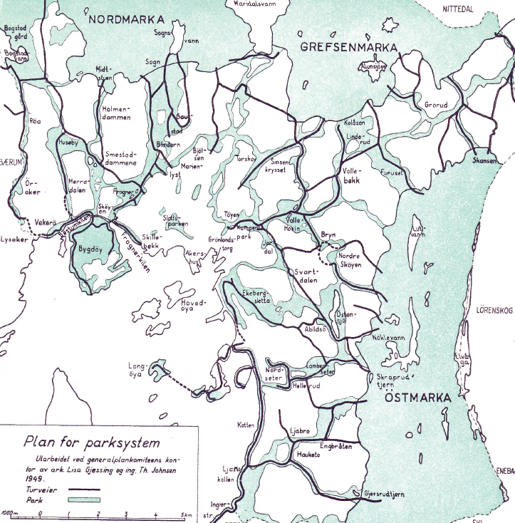
Hals’s ideas and visions were recorded in the 1934 master plan for Oslo and pursued further in the 1950 master plan for the Grorud Valley. Enabled by the merging of the municipalities of Aker and Oslo in 1948, this master plan shows the middle of the valley designated as an industrial area, while scattered housing districts dot the hillsides. Importantly, the master plan also shows an extensive park system. In the plan, continuous park areas connect the valley to the center of Oslo, as well as to the Marka to the east and west. In this context, the 1950 plan testifies to the fact that if North American landscape ideals ever influenced the valley, it is not as a model for horizontal sprawl but as a much older City Beautiful landscape model for landscape distribution and beauty. (fig. 1.11.3)
1.11.3 1949 projective map of park system and pathways in the Oslo area. The proposed interconnection of green zones and the Oslo forest commons, Marka, is striking.
The development of the Grorud Valley relied on government purchase of land for the city to expand after World War II, due to a tremendous demand for housing. The municipality of Oslo gained land from wherever it was available, with a desire to create decentralized urban communities as a respite from concentric urban growth.6 A collective effort to provide housing for a growing population merged with the valley’s peasant culture and property structure. In opposition to traditional notions of suburban development based on cars, the public transport lines were laid down before a massive road and highway development. By 1950, of all peripheral development in Norway, the Grorud Valley was probably the most public transportation oriented from the very beginning, a situation not so common in suburban areas.
The new urban centers in the Grorud Valley are neatly tucked between the Marka boundary and the lower Valley infrastructure and industrial landscapes. (fig. 1.11.4) This is due to climate zones; valleys in Norway tend to be colder, gustier, and more humid than the valley flanks. Also, the slight increase in altitude allows for better views, a sense of loftiness and, not the least—the possibility of accommodating the specifically Norwegian desire to put on your skis right outside your door and take off.
The development of the valley relied heavily on prewar modernistic city planning ideals. The contemporary architect Karl Otto Ellefsen explains that the modernistic ideal in Norway consisted of strong planning, demand for scientific legibility, lifestyle ideals, and architectural ideals.7 The valley as it appears today must be considered a partial expression of planning ideals where “urban technicians” demonstrate an ability to control mass production of buildings and have sufficient knowledge to be at the center of urban development. The role model was the German 1920 city planner, and also the Soviet Union’s collective sharing of property.8 An important condition for the present-day fragmentation of the valley is its former character of being an agricultural area with intermingled and small scale–mining industry and housing areas. When planning commenced, suburban thinking was laid on top of an existing structure of variegated land use—in act, this allowed the new satellite towns (except Romsås) to be weaved into existing property structure and infrastructural systems, mainly older farms, mines, and transportation arteries.
At each successive point in time, the development in the valley reflected different trends in the relationship to landscape, planning ideals, and social policies. The first “wave” from the 1950s, which was inaugurated by the development of Lambertseter, is characterized “by the carefully preserved landscape qualities of the natural forest areas.”9 Land use planning carefully considered access to landscape as a recreational resource, as well as the aesthetic pleasures entailed in the spacing of buildings, composition of buildings, and views from buildings. When the first satellite towns in the valley were planned, there was a strong emphasis on sheltered outdoor playgrounds and the need to prioritize pedestrians and their access to Marka over vehicular pathways.10
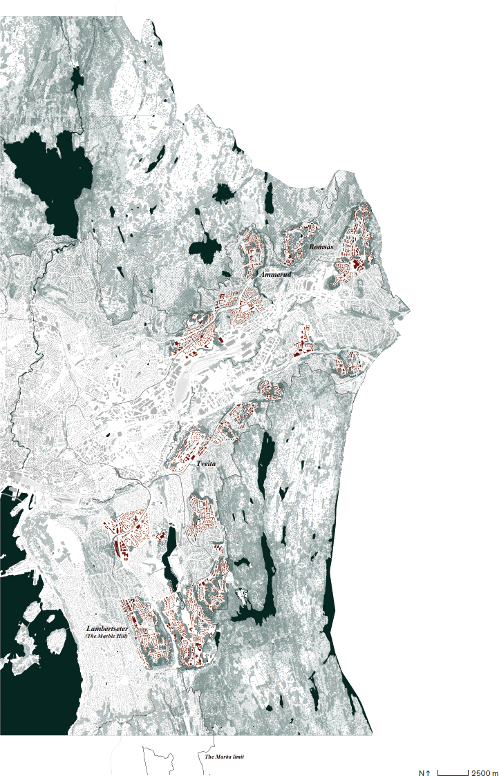
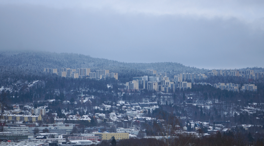
In the 1960s the second wave featured high-rises that were heavily criticized for their alienation of landscape and neglect of their inhabitants, “for not providing the inhabitants with a sense of belonging, identification and sense of community.”11 This second wave of satellite towns in the Grorud Valley may be characterized as “ultramodernistic” in a European context, especially Ammerud (with its fourteen-story buildings) and Tveita.12 (fig. 1.11.5) Although like all Grorud towns, they are “gentler” than most Swedish, Polish, or Belgian ultramodernistic satellite towns, they are relatively low, close to Oslo, and connected to a good public transportation network. In fact, the height of the apartment complexes (130 feet, or 40 meters) harmonizes with the surrounding hills, and the long, low slab rests beautifully in the landscape.13
1.11.5 The urban blocks at Tveita, representative of the second wave of satellite towns in the 1960s
In response to the criticism of ultramodernistic developments, in the 1970s “residential environment” became a buzzword in satellite town planning. It reverts back to the ideals of smaller populated communities and adjustments to the local landscape, aiming to create more people-friendly spaces than the high-rise and Le Corbusier–inspired residential towers erected a decade earlier. Developments built at this time were also planned to be car-free, with roads on the outside connecting to parking garages. All traffic to kindergartens, schools, subway stations, and the forest was to be handled by walking, bicycle, or even skiing.14 (fig. 1.11.6)
The 1980s marked a turn toward extensive market liberalization and, at the same time, the end of a long period of political consensus and stability.15 It reversed the three-decade trend of satellite town planning, and most leftover space in the valley was deregulated for housing infill and new residential districts. The spatial layout of satellite towns survived, however, even though houses and blocks were modified over the decades, with oriels and glassed-in balconies, recultivation and transformation of green areas. (fig. 1.11.7) Property boundaries have more or less remained untouched, in contrast to the widespread subdivision of single-family housing properties occurring in other parts of the city to make space for more buildings.
Despite the relative density of developments in the valley today—a composite of satellite towns, newer urban infill, industrial areas, and infrastructure—it is surprisingly green and in places even bucolic in character. It is not so difficult to see that the first plan for the valley advocated a strong park system, although it was not completed.
The park system in the 1950 master plan for Oslo was strongly influenced by the City Beautiful movement and bourgeois ideals of collective space and shared resources. It sought, however, to find ways for the different housing districts to be both autonomous urban centers and embedded in the natural environment. They were separated from the larger urbanity of Oslo, but still aspired to provide an urban setting. At the same time, they had easy access to the surrounding nature and leisure environments of the Marka. Hence, the valley expresses ambiguity; all centers are infiltrated by or located very close to nature, in concurrence with the original intention for the valley, but lacking the critical mass that would sustain urban life. As a result, these autonomous urban centers perform as merely imitators of urbanity. Now they often perform as empty shopping and management centers in the satellite towns. (fig. 1.11.8) In fact, the spatial qualities around the centers prove more important than the centers themselves; green space, squares, and transit corridors for pedestrians and bikers are qualities still highly sought-after by inhabitants.
The Grorud Valley is a limited geographical space. This limitation may in fact prove incompatible to the imported ideals of large-scale sociospatial organization that have informed its planning. The Valley has served as a laboratory for ideas ranging from the garden city and the City Beautiful to Le Corbusier’s unité d’habitation and the grandeur of socialist commonwealth planning. Yet while the tensions are still unresolved, the spatial dynamics in the valley are open enough to encourage productive future experiments.
The Marka limit forms a political (although originally natural) urban growth boundary. Having been contested over the last years due to the growing need for buildable land, it seems to be withstanding development pressure. Landscape presence is as important in the valley today as in those first years of development and will continue to be the case. As a result, urban development in Oslo is no longer about expansion; instead, it is about the reuse and transformation of urban fragments. In this way, the valley itself is changing, gradually becoming a large urban district.
Yet the most significant change in the valley is demography. Over the last three decades, the valley has become a melting pot of diverse immigrant groups. Playing on the philosopher Marshall McLuhan’s “global village” concept, the Norwegian scholars Thomas Hylland Eriksen and Elisabeth Eide introduced the concept “global satellite town” to describe its present character. It is global, not only in the sense of being tied to a global technology network as described by McLuhan, but also by migration and physical mobility.16 Its demographic composition is an expression of the ethnic variation in present-day European and Norwegian society.
The Valley’s new inhabitants have called into question the traditional Norwegian relationship of nature and housing. The new inhabitants in the valley do not necessarily embrace the culture of cross-country skiing, berry picking, and general wilderness appreciation. In fact, new immigrant groups have different preferences and expectations of a suburban environment than the population it was originally built for. Immigrants from the Middle East and Asia prefer more neighborhood meeting places and outdoor activity areas. Few portions of the inner landscape of the valley accommodate these needs and desires.
Plus, the valley is now on the verge of a major postindustrial economic transformation involving partial obliteration of its industrial areas. This conversion of large industrial areas into other land uses and new neighborhoods offers the opportunity to focus on developing the inner landscape of the valley, which is in need of revival and extension of both its social infrastructure and its physical spaces. In 2007 the municipality of Oslo launched a comprehensive plan for the Grorud Valley, a project aimed at improving environmental and living conditions in the Grorud Valley at large.17 Central to the plan is a scheme for four larger parks, one for each part of the valley. The “Groruddalen Project” thus features a strong park policy, one in which blue-green infrastructure and recreational commons are at the forefront.
The plan extends the park system idea from the 1950 master plan, where landscape structure was conceived of as the backbone in urban development. However, as the Norwegian landscape architect Ola Bettum points out, the 2007 strategy is the inverse of the 1950 plan; instead of closely linking to the Marka surrounding the valley, the new park strategy aims to develop recreational spaces within the valley. The change in focus will bring new attention to the geological layout of this typically Norwegian moraine valley.
In the end, the new Grorud Valley project is less about the visual aesthetics emphasized by the City Beautiful movement than about socially and environmentally efficient landscapes. The project includes daylighting of rivers, revival of wildlife habitats, and an increase in park space similar in scope to the 1950 plan, although interrupted by industrial and infrastructural systems.
In the history of the valley since World War II, the strong presence of landscape and nature created a unique suburban condition. What the municipality of Oslo seems to have learned from the successive stages of suburbanization in this former farming valley is that when a suburban area densifies, changes, and develops into a multicultural region, the status of nature changes. The recent landscape projects in the valley demonstrate that “there is a major political profit to be made from emphasizing parks as part of urban development.”18 The Bjerkedalen Park creates new meeting places in a district with few parks and plazas. (fig. 1.11.9) New pedestrian paths wind through it, and sections of the creek Hovinbekken have been day-lighted. It will be opened throughout the building zone and all the way down to the historical parts of Oslo. This new development proves to partly realize the extensive park system plan from 1950.
1.11.9 The new valley demography demands a need for meeting places and outdoor activity arenas that offer something to people from all culture groups.
Today there is indeed hope that the valley’s inner landscape could be the mechanism that ties up its fragmented housing districts and will also be adapted to address the new social and cultural changes in the area.19 The present challenge entails adapting the City Beautiful ideals that first created the valley’s landscape in order to solve the needs and desires of a global village.
2 Statistics Norway, population January 1, 2015.
3 Store norske leksikon, s.v. “Groruddalen,” by Svein Askheim, accessed February 3, 2015, https://snl.no/Groruddalen.
4 Thirty-nine of the old properties, now turned urban, have names ending in -rud (from rydde: to clear), and -vin (meadow), both of which have ancient roots. Twenty-three of these can be dated based on names—fourteen are medieval, seven from the Viking period, and two date back to before 800 BCE. See Eivind Heide, Groruddalen (Oslo: Tiden, 1980), 27–33.
5 Mikkelsen Ingvar, “Hals’ Og Pedersens Ideologier,” Plan 45, nos. 4–5 (2013): 24–33.
6 Guro Voss Gabrielsen, Groruddalen—Oslos Vakreste Verkebyll? Problemrepresentasjoner Og Stedsforståelser I Groruddalssatsingen 70 (Oslo: Arkitektur- og designhøgskolen i Oslo, 2014), 89.
7 Karl Otto Ellefsen, “Arkitekt Og Planlegger, Arkitekturidealer I Norsk Byplanlegging 1950–2000,” Plan, nos. 5–6 (1999): 77.
8 Ibid.
9 Haslum, Reading Socio-Spatial Interplay, 37, 170.
10 “Byggekunst” (Oslo: Norske arkitekters landsforbund, 1952), 105.
11 Haslum, Reading Socio-Spatial Interplay, 37, 178.
12 Ellefsen, “Arkitekt Og Planlegger, Arkitekturidealer I Norsk Byplanlegging 1950–2000,” 79.
13 Bjørn Bjørnsen, Hele Folket I Hus: Obos 1929–1970 (Oslo: Boksenteret, 2007), 157.
14 Gabrielsen, Groruddalen—Oslos Vakreste Verkebyll? Problemrepresentasjoner Og Stedsforståelser I Groruddalssatsingen 70, 90.
15 Marius Grønning, “What Is the Fjord City?,” Territorio 56, no. 4 (2011): 142.
16 Sharam Alghasi, Elisabeth Eide, and Thomas Hylland Eriksen, Den Globale Drabantbyen: Groruddalen Og Det Nye Norge (Oslo: Cappelen Damm akademisk, 2012), 8.
17 Guro Voss Gabrielsen’s PhD dissertation deals with this project.
18 Parkpolitikk, vol. 06-2014, Parker I Groruddalen; Geilo Sentrum; Asker Rådhus; Konsept? (Oslo: Norske arkitekters landsforbund, 2014), 51.
19 Karl Otto Ellefsen, “Idealer I Norsk Bolig-Og Byplanlegging I De Siste Tiårene,” Plan 35 ER, no. 1 (2003): 6.