
It is no coincidence that some of the most dynamic and complex metropolitan conditions—such as postindustrial sites, historic urban cores, dynamic estuaries, peri-urban fringes, and informal settlements—cannot be neatly categorized through the reductive nature of zoning. Despite zoning’s regulatory evolution, it remains faithful to its original goal: the well-defined separation of land uses.1 Such normative divisions have resulted in static conditions that overlook local nuances and are especially unmindful to factors of time and change.2 In suburbia, this goal is epitomized in the proliferation and inviolability of the “single-family residential” zone as an “end state” zone, which is protected from any transformation. Over time, conventional zoning has proved ineffective in dealing with the “complex and unwieldy reality” of contemporary urbanism, especially in the face of increased vulnerability created by indeterministic, unknown, and varied environmental forces.3
Yet it is in the suburban fringes of the polycentric metropolis where conditions become ripe for experimentation in dynamic, process-driven codes and standards that revolutionize traditional zoning’s static outcomes. The opportunity for innovation is due not just to the abundance of land for ecosystem services but also to the decrease in the complexity of regulation and land ownership, as well as the low cost of the development process (as evidenced by the large-scale planned unit developments [PUDs] seen in suburbia). Thus, suburbia represents a latent opportunity to innovate in terms of the flexibility of building programs and building forms, and importantly, the provision of new infrastructure that may be constructed in a sustainable, innovative, and metabolic matter.
Roots of land-use controls develop in North America in the first centuries of settlement due to multiple, interacting factors: an abundance of land coupled with an agrarian economy, a strong belief in private property, and the fear of density and chaos associated with the industrial city.4 In pursuit of order, legibility, and control of the territory, early surveyors produced a set of instrumental and reductive tools, such as the Jeffersonian grid, and later, structures of subdivision, land-use provision, building codes, and zoning. These tools were a clear product of the influence of ecological paradigms on American law and policy and were bolstered by Progressive Era judicial powers. Taken together, these tools have been shaping the North American territory in an unimpeded and marginally altered fashion ever since their conception. In fact, zoning remains the most influential and pervasive regulatory tool ever deployed.5
It is in the diminution of legislative complexity on the suburban fringes of the polynodal metropolis, where conditions are ripe for the flexibility of program, the affordability of experimentation, and space for formal, infrastructural, and economic innovation. Yet the standard tools we have inherited, and continue to universally deploy across terrains, remain true to their original purpose of a reductive and inflexible partition of uses—leading to an ecologically derived fallacy of a city in a preferred, “climax, end-state.”
For once it is realized that there is no harmony of nature, no divine or other purpose hidden beneath the flux and chaos of present planlessness, it becomes immoral to let poverty, ignorance, pestilence, and war continue if they can be obliterated by a “plan.”6
Ever since ecology was recognized as an essential branch of biological science at the turn of the last century, a fundamental, yet often underplayed, link between ecology, planning policy, and land-use legislation was established.7 A leading political scientist, Dwight Waldo was a defining figure in American modern public administration during the post–World War II era. Statements such as the one above solidified the ethos of the planning profession as one that could achieve higher objectives as an administrative profession. The notion of an “equilibrium” reached through formulaic standards would abolish “planlessness,” increase legibility and control, and eradicate the potentials of indeterministic chaos as a moral public imperative.8
Yet as concerns over the environment and its uncertainty propels us to rethink our models of twenty-first-century urbanization, it is crucial to recount the original links between ecological paradigms and planning policy, but more important, allow for the evolution of ecological theories to once again influence the transformation of such policy tools. Four distinct ecological ideas have directly shaped public policy and legal institutions in the United States during the Progressive Era and created suburbia as we know it.9
The first Progressive Era policies were highly influenced by ideas of ecological “empiricism,” in which scientific thought comes from factual reasoning rather than abstract principles.10 The second, which focuses on the concepts of “succession, climax, and equilibrium,” developed by the ecologist Frederic Clements, had the most profound impact on American planning and the passing of the Standard Zoning and Enabling Acts during the late 1920s.11 The third corresponds to the expansion of the concept of “metabolic habitat” and the eventual development of systemic ecology.12 This is subsequently supplanted by the environmental scientist Daniel Botkin’s notions of “non-equilibrium” and open-ended paradigms, which claim that the environment is in a constant state of flux and change, and so our public policy should also be changing.13
When ideas around ecological succession (where one biological community replaced another in successive waves) began to take hold, the greatest impact on public planning policy was not the idea of dynamic succession itself, vis-à-vis change, but the contention that succession eventually would reach a “climax state” and then succession would cease into a perfected state.14 Planners, and the legal system that backed them, believed that if there was a permanent ideal use for every piece of land, then the law ought to give the use a protected status and obstruct any activity that would conflict with that use—calling it “the highest and best use.”15
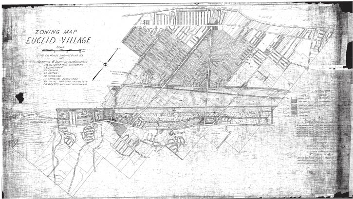
The landmark case of the Village of Euclid, Ohio v. Ambler Realty Co. (1926) gave birth to the Standard State Zoning Enabling Act (1926) and, later, the Standard City Planning Enabling Act (1928).16 (fig. 5.2.1) The result of both acts was legally mandating zoning for every municipality, but not comprehensive planning per se.17 This resulted in a rift between the need for immediate enforceable sanction of uses in the present and the evolving needs of the future.18 As such, this propagated “decades of confusion among officials and planning professionals where municipalities resorted to zoning, an inherently short-term tool, as the primary device for drawing up long-term plans.”19 States enacted laws permitting cities to establish a zoning commission before devising any kind of long-range or comprehensive city plan.20 As such, this precise administrative planometric policy tool, usually composed of a visually simplified hatch or color representing a future condition, became the exact and immediate legislative spatial blueprint for the development of the land.21 (fig. 5.2.2)
5.2.1 Euclidean zoning is a type of zoning named for the Village of Euclid where zoning was upheld in 1926 as a legitimate governmental power under the police powers of government. Euclidean zoning codes are based on the earliest comprehensive ordinances and the Standard State Zoning Enabling Act (1922).
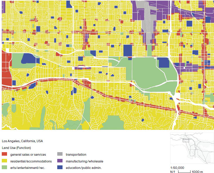
5.2.2 Existing land-use map of a Los Angeles suburb. Illustrated with reductive land-use primary colors as mandated by the American Planning Association’s Land-Based Classification Standards
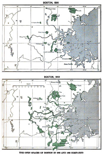
Early accounts of “comprehensive planning” practice, before the 1926 Standard State Zoning Enabling Act, reveal a robust form of projective physical planning that took into account a multitude of social, infrastructural, formal, and environmental concerns—to which zoning was envisioned to be an enabling, rather than a restrictive, mechanism.22 For example, as the environmental ills of the industrial city were becoming more rampant, Frederick Law Olmsted Jr., landscape architect and one of the fathers of professional planning, together with Alfred Bettman, the Cincinnati lawyer amicus in the 1926 case of the Village of Euclid v. Ambler Realty Co., anticipated the development of land-use zoning.23 They were pivotal in shaping the federal legislation meant to arm physical planners with an “enabling mechanism” to perform comprehensive planning—not as the exception, but as the standard across the country.24 Yet the comprehensive planning projects of Geddes, Mumford, Burnham, and Olmsted Sr., where park systems, mobility, hydrology, infrastructure, housing, health, society, and development were thought of holistically and comprehensively, remained exceptional cases of planning the industrial city as soon as zoning was mandated.25 (fig. 5.2.3) Soon after, the role of land-use zoning in propagating what we consider suburbia today became irrefutable.
5.2.3 Illustration of the growth of the Metropolitan Park System of Greater Boston between 1892 and 1902 as illustrated by the landscape architect Charles William Eliot. This echoes other plans occurring across the county, such as the McMillan Plan of District of Columbia park system, as proposed by the United States Senate Park Commission in 1902.
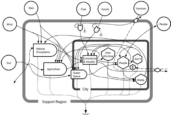
It was in the decades immediately following zoning’s legalized mandate that its expedited proliferation through federal initiatives such as the 701 Program, the Federal Housing Programs, and the New Deal, further established the link between land-use zoning and the process of suburbanization. (fig. 5.2.4) The idea of national planning mandated by the Supreme Court was to identify future equilibria and the climax condition of human communities for every part of the country.26 As zoning became legal, planners were tasked with preparing “plans that projected a future use of every parcel of land in their jurisdiction.” Some neighborhoods, mainly established single-family residential ones, were seen as “climax communities” that needed protection, while others were in successional transition.27 Planners issued a “Plan for the year X,” to which all processes of change and transformations were assumed to culminate.28
5.2.4 Model adapted from City as a System Diagram, showing energy system and flows of a city in its support region
In a survey of planning and zoning progress in the United States, published by Harvard University Press in 1929, Theodora Kimball Hubbard and Henry Vincent Hubbard exulted model municipal administrators who were achieving maximum uniformity of land use and the protection of single-family use districts. Madison, Wisconsin, for example, “reported the strictest administration where no variances in use have been granted,” and they referenced “the suburban city of Newton, Massachusetts, as “having the most remarkable record of excellent zoning administration…where by 1925 nearly 80 per cent of the city area is zoned for single-family residence.”29
It was the exclusivity and sanctity of this category that was one of the primary reasons of public support for zoning in twentieth-century America.30 In contrast to multifamily dwellings, which were seen as unhealthy urban tenements, along with incompatible industrial uses, the single-family residential zone was viewed as salvation from the problems of health, safety, and morality.31 In other words, it was to be a protected “climax end state condition,” the rationale behind providing more of these zones across the once agricultural edge, and the justification of state control over private property. This established the basis of land use as the reflection of the value orientations of those decision makers at a specific moment in time.32 Now long lost to the process-based bureaucratic milieus of practice and the single-function municipal plans, it is argued that the North American continent is zoned, and not planned.33
Many of the failings of the top-down modernist planning schemes evolved when ecosystem thinking took place.34 For example, when the Odum brothers developed the building blocks of contemporary ecology as webs and chains of food, trophic levels, productivity, energy flows, and metabolism, the emphasis placed on “communities” rather than “individuals” meant that the habitat (neighborhood, district, community) rather than the individual (private property) must be thought of holistically and systemically.35 Bureaucrats began to understand the idea that if one exerted control on a certain coefficient, such as food, water, or energy, one could then affect metabolism, growth, and dominant species in that ecosystem.36 Economists, engineers, and environmental policy makers quickly adapted these basic principles from ecology, understanding their consequence on human activity and natural resources by passing environmental laws at a national scale.37
While the federal government enacted a series of national policies that influenced the built and natural environments, such as the National Environmental Policy Act 1969 and the Clean Water Act 1972, such acts remained expensive, inefficient, and ill-suited to shaping local policy at the planning scale.38 As the suburban model ceaselessly burgeons, the role of an evolved paradigm of ecology in planning and design should become a fundamental priority in making decisions about land use and built form.39
The most contemporary ecological paradigm with the greatest potential of affecting planning standards today is best described by the environmental scientist Daniel Botkin. Botkin was the first to challenge the prevailing view that the environment remained constant over time and “achieves a form and structure that would persist forever” unless disturbed by human influence. Many still believe that “if left undisturbed, nature would recover, returning to a state of perfect balance.”40 In his seminal texts Discordant Harmonies (1990) and The Moon in the Nautilus Shell: Discordant Harmonies Reconsidered (2012), Botkin makes the claim that while human action is both a predictable and a random principal powerful force operating on the world, “it is impossible to return to an ideal nature, because ecosystems are patches or collections of conditions that exist for finite periods of time” and are inherently in a state of flux.41 He further contends that ecosystems may only be managed, but never truly restored or preserved. Typical land-use zoning still hinges on the previous equilibrium and successional paradigms that are driven by a notion of a perfected universal end-state. This static end image continues to influence much of planning practice and master-planned proposals and documents, when in fact we require a dynamic view of the environment, and therefore dynamic tools and policies for the profession.42
What then of the role, instrumentality, and agency of urban designers and physical planners in light of a paradigm that doesn’t end in “climax end-state”? These questions are becoming extremely evident and timely when dealing the horizontal, expansive polycentric metropolis, as well as places that are highly vulnerable to climatic risks, such as coastal areas.
The wider performative, or process-based, aspects of infrastructure remain at the helm of a centralized core of knowledge within engineering.43 As such, physical planners are left with the object-based, descriptive metrics of separating the land into sections or zones with different rules that govern the structures on them. Existing standards begin by describing the primary use of the land or its function. This determines the kinds of programmatic activities that are allowed to occur inside the structure(s) built on the parcel (such as residential, commercial, institutional, industrial). The second parameter is the shape of the structure in its two- or three-dimensional configuration (height, setback, etc.). The third parameter is the bulk (how much building can be placed on a unit of land (floor area ratio, maximum build-out, maximum number of buildings per unit land, maximum or minimum density, etc.).44
The first to recognize the opportunity of transforming contemporary suburbia using a set of innovative codes and standards were the New Urbanists. By recognizing the instrumentality of standards, “form-based codes” were institutionalized at the scale of the domineering suburban PUD.45 The New Urbanists saw an opportunity in the expansiveness and ubiquity of PUDs as an occasion to construct a neotraditional narrative around pedestrian-oriented, dense, compact, and nostalgia-themed neighborhood patterns by mutating the code of suburban development. Density was assumed as sufficient in offsetting environmental concerns of suburban sprawl, especially that of carbon emission.46 Yet it is precisely because neotraditional code starts with the static “form” and aggregation of objects (buildings, building use, style, laneways, awnings, and porches), rather than dynamic “process” of environmental functions (flow, fluxes, change, transformation), as the foundation of codes that their efforts have only resulted in a kind of permanent “inflexibility” with negligible shifts at the metropolitan scale, especially from an environmental perspective.47
In fact, form-based codes go a bit further in advocating for the delineation and clear separation of “environmental” services from what New Urbanists traditionally associate with the “city.” Andrés Duany, the architect and founder of New Urbanism, argues, “Environmentalism inadvertently enforces and leads to suburbanization.”48 Rather than interweaving the environment as a foundational and structural aspect of the built environment, New Urbanists claimed that many of the environmentally driven regulations, such as groundwater recharge, on-site storm-water detention, minimum permeable square footage for tree planting, protection of wetlands, greenways, wildlife corridors, “all favor ‘dendritic’ street patterns characteristic of conventional suburbia.”49
Using the notion of “transect” zoning, New Urbanists claim that natural wilderness “successionally” evolves into an urban “climax” expressed mainly through building density and their ideal city-form. As such, environmental regulations requiring space would remain on the fringe of the metropolitan region. (fig. 5.2.5) In the conceiving of a set of novel codes for “permanent flexibility,” however, the artificiality of such boundaries and segments are futile. Systems, such as water flow, biodiversity, ecosystem services, and metabolic transfers, are never neatly contained within predefined segments; instead the opportunity is there for them to become generative of complimentary and relational built forms and land uses at the metropolitan scale.50
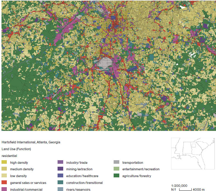
5.2.5 Existing land-use map of the Atlanta region using the American Planning Association’s Land-Based Classification Standards. Residential enclaves are nestled in between large swaths of open space and forests that hug infrastructural routes.
By revisiting what constitutes a land use or a zoning code, by including probability and uncertainty as a parameter, by allowing it to “expand and contract,” evolve and become dynamic, such tools may become enabling, contextual, and responsive—rather than restrictive or reactionary measures derived through contextual, and process-driven protocols.51 A way of opening up future coding and standards of planning starts by coupling dynamic process-driven language from landscape and ecology with land use to create open-ended, yet quantifiable, scenario-driven plans.
Suburbia and the exurban fringe are the ideal location for the advancement of novel types of process-driven standards and codes. This is due not just to the abundance of land for ecosystem services but also to the decrease in the complexity hurdles and cost of the development process. The fastest rates of conversation in the metropolitan region is highly associated with the developer’s decisions to build homes in the suburbs or exurbs to offset the cost of land brought on by heavy regulations closer to the urban core and established neighborhoods.52
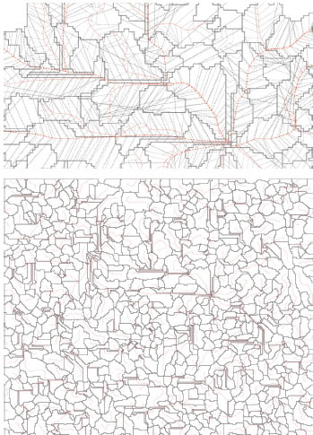
Suburbs are also an opportunistic space in policy- and decision-making processes. Many forms of regional control such as greenbelts and growth boundaries for environmental or conservation decisions assume that land is being “wasted” for development purposes. Various studies have showed, however, that no more than 6 percent of the total land area of the United States (excluding Alaska) is devoted to urban land uses.53 Yet it is precisely the separation of land uses into reductive categories (such as residential and conservation areas) that make it illegal for tapping into the coupling of uses and the creation of feedback mechanisms from an infrastructural (wastewater cycling, water storage, and energy generation, for example) and programmatic (agriculture, recreation, environmental, and employment) point of view. Such restrictions further limit the potentials of innovative forms of subdivision and housing typologies, as it perpetuates the excessive use of land for singular purposes, which some critics condemn as “sprawl” and “leap frogging.” (fig. 5.2.6)
5.2.6 A propositional subdivision scheme that uses the natural drainage patterns to clearly demarcate micro-watersheds that run along and through the site. This acts as the first step in decentralizing hydrological infrastructure on greenfields or the exurban edge.
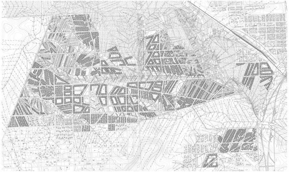
The process of land subdivision has followed the same standards adopted by the Federal Home Finance Agency since the late 1930s, and many of the obstacles for innovation often appear in the administration of street layout and their associated grading and drainage. “Sewerage, not planning, dominates the growth game” declare the sanitary engineers to county planning staff.54 The opportunity, however, for novel types of land uses and standards leading to “permanent flexibility” may emerge by strategically intervening in three uniquely suburban development approvals processes. The first is the benefit of working on PUDs, which streamline large swaths of land ownership, and then continues to manage and oversee the agreed covenants and rules of the individual owners once the property has been purchased. The second is the provision of brand-new infrastructure, especially water and wastewater, to be constructed in a sustainable, innovative, and metabolic matter. And third is in the process of large-scale grading and earth work, in favor of netpositive ecosystem service at the watershed scale. (fig. 5.2.7) Once such a system is in place, the buildings’ floor area ratios, foundations, setback, density, height, and use emerge as a reflection of the bigger systemic and environmental process-based coding on the suburban fringe. (figs. 5.2.8–9)
5.2.7 The built form (objects) and their aggregation emerge as a reflection of novel systemic and process-based coding such as flooding, soil, and solar variables
5.2.8 A future planned unit development that protects the most arable land from development, allows for the most floodable areas to become points of collection and treatment, and imagines novel forms and patterns of urbanization on the suburban edge.
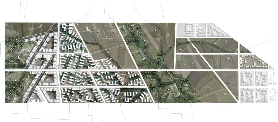
5.2.9 Rendered detail of one possible segment of the PUD showing various density variables and land-use conditions.
Newer ecological theories vary, but tend to see the environment in a process of constant change and flux, rather than one with a stable end-state. Environmental law may have adapted to new paradigms, but planning policy derived during the Progressive Era remains embedded in the static concept of a future condition tied to the “end-state planning.” This essay proposes that in the diminution of regulatory planning tools and the erosion of code in certain contexts, such as the suburban edges of the polynodal metropolis, brown-fields, coastal areas, and estuaries, that we may propose novel land uses and forms of occupation. As such, zoning remains the most prolific and powerful tool at the purview of urbanists and planners, as the starting point for such transformations. In the most ubiquitous condition of urbanization, potential new models could arise in the suburban fringe, where the privation of overregulation and the abundance of space allow for transformative innovation and experimentation in code, process, and form.
Ultimately, this condition establishes an opportunity for policy planning to be a part of the design process and a progeny of it. This brings design thinking into the powerful domain of public decision making by including it in the precise edicts of urbanism, and not acting as the exception to it.
2 Rutherford H. Platt, “Land Use Control: Interface of Law and Geography,” Resource Paper No. 75–1, January 1976, accessed January 20, 2016, http://Eric.Ed.Gov/?Id=ED155111; Sidney M. Willhelm, Urban Zoning and Land-Use Theory (New York: Free Press of Glencoe, 1962); Eran Ben-Joseph and Terry S. Szold, eds., Regulating Place: Standards and the Shaping of Urban America (New York: Routledge, 2005).
3 Referring to Judge Sutherland’s plea for zoning to be flexible in dealing with the world’s “complex and unwieldy reality,” Village of Euclid v. Ambler Realty Co., 272 US 365 (1926), accessed April 21, 2015, https://Supreme.Justia.Com/Cases/Federal/Us/272/365/Case.Html.
4 Richard F. Babcock, Zoning Game: Municipal Practices and Policies, Underlining/Highlighting Edition (Madison, WI: Lincoln Institute of Land Policy, 1966).
5 Fred P. Bosselman, “The Influence of Ecological Science on American Law: An Introduction,” Chicago-Kent Law Review 69 (January 1, 1994): 847; Serkin and Macey, “Post-Zoning”; Sonia A. Hirt, Zoned in the USA: The Origins and Implications of American Land-Use Regulation (Ithaca, NY: Cornell University Press, 2014).
6 Dwight Waldo and Hugh T. Miller, The Administrative State: A Study of the Political Theory of American Public Administration (New Brunswick, NJ: Transaction Publishers, 2006).
7 Bosselman, “The Influence of Ecological Science on American Law”; Daniel B. Botkin, Discordant Harmonies: A New Ecology for the Twenty-First Century (New York: Oxford University Press, 1990), accessed January 20, 2016, http://libproxy.mit.edu/login?url=http://search.ebscohost.com/login.aspx?direct=true&db=cat00916a&an=mit.000515749&site=eds-live; Daniel B. Botkin, The Moon in the Nautilus Shell: Discordant Harmonies Reconsidered (Oxford: Oxford University Press, 2012); Frank B. Golley, A History of the Ecosystem Concept in Ecology: More Than the Sum of the Parts (New Haven, CT: Yale University Press, 1993), accessed January 20, 2016, http://libproxy.mit.edu/login?url=http://search.ebscohost.com/login.aspx?direct=true&db=cat00916a&an=mit.000674054&site=eds-live.
8 Waldo and Miller, The Administrative State.
9 Bosselman, “The Influence of Ecological Science on American Law”; Golley, A History of the Ecosystem Concept in Ecology.
10 Joseph Postell, “The Anti-New Deal Progressive: Roscoe Pound’s Alternative Administrative State,” Review of Politics 74, no. 1 (January 2012): 53–85.
11 Arnold Valk, “From Formation to Ecosystem: Tansley’s Response to Clements’ Climax,” Journal of the History of Biology 47, no. 2 (May 2014): 293–321.
12 Postell, “The Anti-New Deal Progressive.”
13 Botkin, Discordant Harmonies; Botkin, The Moon in the Nautilus Shell.
14 Bosselman, “The Influence of Ecological Science on American Law”; Golley, A History of the Ecosystem Concept in Ecology.
15 Hirt, Zoned in the USA; Platt, “Land Use Control.”
16 Hirt, Zoned in the USA.
17 A. Dan Tarlock, “Zoned Not Planned,” Planning Theory 13, no. 1 (February 1, 2014): 99–112.
18 Thomas Deckker, The Modern City Revisited (London: Spon Press, 2000); Babcock, Zoning Game.
19 Ruth Knack, Stuart Meck, and Israel Stollman, “The Real Story behind the Standard Planning and Zoning Acts of the 1920s,” Land Use Law & Zoning Digest 48, no. 2 (February 1, 1996): 3–9; Platt, “Land Use Control.”
20 William I. Goodman and Eric C. Freund, Principles and Practice of Urban Planning, Municipal Management Series (Washington, DC: Institute for Training in Municipal Administration by the International City Managers’ Association, 1968), accessed January 20, 2016, http://libproxy.mit.edu/login?url=http://search.ebscohost.com/login.aspx?direct=true&db=cat00916a&an=mit.000857747&site=eds-live.
21 Ibid.
22 Charles M. Haar, “The Content of the General Plan: A Glance At History,” Journal of the American Institute of Planners 21, nos. 2–3 (June 30, 1955): 66–70; Goodman and Freund, Principles and Practice of Urban Planning.
23 Michael Allan Wolf, The Zoning of America: Euclid v. Ambler (Lawrence: University Press of Kansas, 2008).
24 American Planning Association, Proceedings of the Fourth National Conference on City Planning (Boston: American Planning Association, 1912); Knack, Meck, and Stollman, “The Real Story.” This is similar to how the New Urbanists and smart growth devised “form based codes” and transect planning to enable much of their agendas. These codes have been adopted as law in over 252 municipalities. See Tony Perez, “Misconceptions About Form-Based Codes,” Form-Based Codes Institute, October 20, 2014, http://formbasedcodes.org/articles/misconceptions-form-based-codes.
25 The Plan for Chicago, the McMillan Plan for Washington, and the Emerald Necklace of Boston, among others; Ben-Joseph and Szold, Regulating Place; Deckker, Modern City Revisited.
26 Haar, “The Content of the General Plan.”
27 Bosselman, “The Influence of Ecological Science on American Law”; Deckker, Modern City Revisited; Edward J. Kaiser and David R. Godschalk, “Twentieth Century Land Use Planning: A Stalwart Family Tree,” Journal of the American Planning Association 61, no. 3 (September 30, 1995): 365–85.
28 Peter J. Taylor, “Technocratic Optimism, H. T. Odum, and the Partial Transformation of Ecological Metaphor after World War II,” Journal of the History of Biology (1988); Babcock, Zoning Game.
29 Theodora Kimball Hubbard and Henry Vincent Hubbard, Our Cities Today and Tomorrow: A Survey of Planning and Zoning Progress in the United States (Cambridge, MA: Harvard University Press, 1929), 175.
30 Hirt, Zoned in the USA.
31 Tarlock, “Zoned Not Planned”; Sonia Hirt, “Form Follows Function? How America Zones,” Planning Practice and Research 28, no. 2 (2013): 204–30; Hirt, Zoned in the USA.
32 Hirt, Zoned in the USA.
33 Tarlock, “Zoned Not Planned.”
34 Taylor, “Technocratic Optimism.”
35 Ibid.; Golley, A History of the Ecosystem Concept in Ecology.
36 Taylor, “Technocratic Optimism.”
37 Bosselman, “The Influence of Ecological Science on American Law.”
38 Virginia S. Albercht, “Role of Environmental Regulation in Shaping the Built and Natural Environment,” in Ben-Joseph and Szold, Regulating Place, 271.
39 Alexander J. Felson and Steward T. A. Pickett, “Designed Experiments: New Approaches to Studying Urban Ecosystems,” Frontiers in Ecology and the Environment 3, no. 10 (2005): 549–56.
40 Botkin, Discordant Harmonies; Botkin, The Moon in the Nautilus Shell.
41 Botkin, Discordant Harmonies.
42 Ibid.; Botkin, The Moon in the Nautilus Shell.
43 Pierre Bélanger, “Landscape as Infrastructure,” Landscape Journal 28, no. 1 (January 1, 2009): 79–95.
44 Jerold Kayden and Charles Haar, Zoning and the American Dream (Chicago: Planners Press, 1989).
45 Hirt, “Form Follows Function?”
46 Eran Ben-Joseph, The Code of the City: Standards and the Hidden Language of Place Making (Cambridge, MA: MIT Press, 2005); “Center for Applied Transect Studies,” accessed December 7, 2015, http://transect.org/transect.html; “Form-Based Codes Defined,” Form-Based Codes Institute, accessed December 7, 2015, http://formbasedcodes.org/definition.
47 Garnett, “Redeeming Transect Zoning?”
48 Andrés Duany and David Brain, “Regulating as If Humans Matter: The Transect and Post-Suburban Planning” in Ben-Joseph and Szold, Regulating Place, 305.
49 Ibid.
50 Sybrand P. Tjallingii, “Ecology on the Edge: Landscape and Ecology between Town and Country,” Landscape and Urban Planning 48, nos. 3–4 (May 1, 2000): 103–19.
51 Alan Berger, Systemic Design Can Change the World (Amsterdam; Baarn: Sun Architecture, 2009).
52 Bernard H. Siegan, “The Benefits of Non-Zoning,” in Ben-Joseph and Szold, Regulating Place.
53 Ibid., 223.
54 Richard D. Tabors, Michael H. Shapiro, and Peter P. Rogers, Land Use and the Pipe: Planning for Sewerage (Lexington, MA: Lexington Books, 1976).