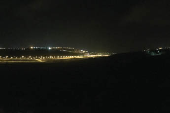

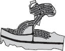
The bright lights of the Jewish hilltop suburbs shine above the darkened Palestinian villages and towns in the valleys of Samaria and Judea. (fig. 5.10.1) In its contrast of light and darkness, the Samarian night reveals more than it hides: the illuminated urban layout of the Israeli settlements and their connected road systems shows itself as a network cast onto the mountains and hilltops of the occupied territories of the West Bank. This network is one of power and surveillance, of one population’s control over another. At night, the other side of what by day might seem like a harmless suburban environment of single-family detached homes is exposed as an invasive and violent intrusion on the landscape and livelihoods of the Palestinians it seeks to suppress.
5.10.1 Night view of the Cross-Samaria Highway with the settlement Barkan on the hilltop in the background
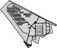
In 2003 Eyal Weizman and I published A Civilian Occupation: The Politics of Israeli Architecture, a collection of essays, photos, and plans that explore how architecture, urban planning, and landscape design have had a hand in shaping the Israeli-Palestinian conflict.1 The project viewed the landscape and built environment of the occupied territories of the West Bank through the conventional tools of urban development: infrastructure and housing. It construed the landscape as a battlefield—a spatial matrix of forces in a continuous process of transformation, adaptation, construction, and obliteration. We argued that in this environment, where architecture and planning had been systematically instrumentalized as executive arms of the Israeli state, planning decisions directly serviced national and geopolitical objectives to seize land and exercise control over the Palestinian population. Unfortunately, these arguments remain relevant today. Some of these issues, and a description of a selection of settlement plans, follow. (fig. 5.10.2)
5.10.2 Jewish Settlements in the West Bank, Built-up Areas and Land Reserves, May 2002. Section from map of Israeli settlements in the West Bank. B’Tselem, Eyal Weizman. Reprinted from Rafi Segal, Eyal Weizman, A Civilian Occupation: The Politics of Israeli Architecture.
The first Jewish settlements of the West Bank were established in the Jordan Valley during the early years of Israel’s occupation, 1967–77. Fifteen agricultural villages (kibbutzim and moshavim) were then built under the Labor government’s rule to establish a secure border with Jordan. Following the political turnabout of 1977, which saw the right-wing Likud Party rise to power, the political climate in Israel changed. Settlements began to be established in the mountain region in and around the Palestinian cities and villages, with the intention of annexing the area to prevent territorial concessions. It was during this time that a suburban model replaced the agricultural settlement as the occupation’s prevailing urban typology. These communities were designed, and often marketed, as extended suburbs of the larger Jerusalem metropolitan area. Much of the West Bank began to be considered a part of the sacred, biblical landscape associated with Jerusalem. As Weizman explains, “The extension of the city’s ‘holiness’ to the new suburbs was conceived as part of Israeli attempts to generate widespread public acceptance of the newly annexed territories.”2
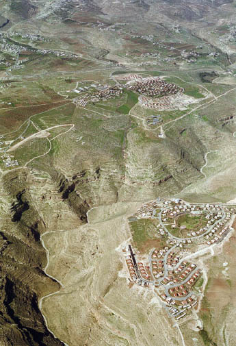
The mountain peaks of the West Bank easily lend themselves to state seizure. Land ownership has been hard to ascertain ever since the Ottoman rule of Palestine, when residents paid tax only on the lands they cultivated. These lands later reverted to private ownership. Areas determined to be under continuous cultivation remained in private Palestinian ownership, and the rest was declared state property. Since Palestinian-cultivated areas are mainly located in valleys and along mountain slopes where agriculturally suitable soils exist, the barren hilltops, along with isolated plots and discontinuous islands around the mountain peaks, became easy targets for annexation by the state.3
These hilltop areas became the sites of Jewish settlements, usually as dormitory communities. Assisted by considerable government subsidies, a settler could purchase a newly built, single-family detached home for the price of a small apartment in Tel Aviv. These suburbs offered newly constructed homes and roads, along with plenty of space, clean air, and panoramic hilltop views. It was all less than half an hour away from the city centers of either Jerusalem or Tel Aviv.
Most of these settlements are structured in a concentric layout, with the topographical contours of the mountain retraced as lines of infrastructure. The roads are laid out in rings around the summit, with water, sewage, and electricity lines buried beneath them. Land is divided into equal, repetitive lots, each containing a single-family house sited along the road, and facing the landscape. While the ideal form for these suburbs is the circle, in reality the plan is distorted, as it has had to adapt to irregular topography and the form and extents of available state land.
Vision plays a key role in every aspect of the design. The arrangement of homes around the summits directs the residents’ gaze outward. This produces sight lines for surveying the landscape to attain different forms of power: strategic, in overlooking main traffic arteries; controlling, by watching over Palestinian towns and villages; and defensive, in overlooking the immediate surroundings and approach roads. The settlements are, in effect, optical devices designed to exercise control through supervision and surveillance.
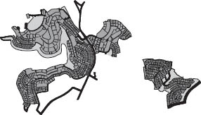
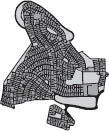
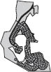
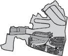
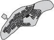
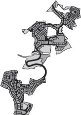
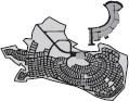
The spatial layout of these settlements—the arrangement of infrastructure and distribution of house lots—reveals the design principles and strategies at play. (fig. 5.10.3) The diagrams presented here are abstracted urban plans of West Bank Jewish settlements in which the roads are rendered in black, housing lots in dark gray, and commercial or public land uses in medium gray (these only appear in a few settlements) and the lightest gray. A contour line depicts the extent of the municipal boundaries of each settlement; included within these borders are areas that have already been designated for future expansion as part of the master plan. The light gray areas reveal where these settlements will grow in the future. The three primary urban elements that have created this typology—roads, single-family lots, and developable land—are the core elements that make up suburbia.
Tapuah
Area: Nablus
Population: 350
Established: 1978
Location on map: F6
Latitude: 650
Type: Community Settlement
Planner: M. Ravid
Giva’at-Ze’ev
Area: Ramallah
Population: 10300
Established: 1983
Location on map: E9
Latitude: 760
Type: Local Council
Planner: Nehemya Gorali
Mizpe-Yeriho
Area: Jericho
Population: 1200
Established: 1978
Location on map: G9
Latitude: 160
Type: Community Settlement
Planner: The Settlement Planning Department

Talmon
Area: Ramallah
Population: 1200
Established: 1989
Location on map: E8
Latitude: 560
Type: Community Settlement
Planner: A. Wilenberg, Gile’adi

Na’aran

Ma’on
Area: Hebron
Population: 250
Established: 1981
Location on map: E14
Latitude: 770
Type: Community Settlement

Ofarim
Qedar
Area: Jerusalem
Population: 450
Established: 1985
Location on map: G10
Latitude: 440
Type: Community Settlement
Planner: The Settlement Planning Department
Tomer
Area: Jordan Valley
Population: 300
Established: 1976
Location on map: H7
Latitude: -220
Type: Moshav
Planner: Yiga’al Levy
Oranit
Area: Jenin
Population: 5000
Established: 1985
Location on map: D6
Latitude: 140
Type: Local Council
Noqedim
Area: Bethlehem
Population: 600
Established: 1982
Location on map: F11
Latitude: 570
Type: Community Settlement
Planner: The Settlement Division of the Jewish Agency
Sal’it
Area: Tul Karem
Population: 500
Established: 1977
Location on map: D4
Latitude: 260
Type: Moshav

Kochav-Ya’acov
Area: Ramallah
Population: 2200
Established: 1984
Location on map: F8
Latitude: 765
Type: Community Settlement
Planner: Eyal Itzki

Na’ale
Area: Ramallah
Population: 150
Established: 1985
Location on map: D8
Latitude: 430
Type: Community Settlement
Planner: A. Wizenthal

Yafit
Area: Jordan Valley
Population: 150
Established: 1980
Location on map: H2
Latitude: -245
Type: Moshav

Ma’ale Levona
Area: Nablus
Population: 500
Established: 1982
Location on map: F6
Latitude: 734
Type: Community Settlement
Planner: Rachel Walden

Bet-Horon
Area: Ramallah
Population: 750
Established: 1977
Location on map: E8
Latitude: 620
Type: Community Settlement
Planner: The Settlement Planning Department
Rimmonim
Area: Jericho
Population: 500
Established: 1977
Location on map: G8
Latitude: 680
Type: Moshav
Planner: The Settlement Planning Department

Ateret
Area: Ramallah
Population: 300
Established: 1981
Location on map: E7
Latitude: 720
Type: Community Settlement
Planner: S. Melman, A. Kaplan
Zufim
Area: Tul Karem
Population: 850
Established: 1989
Location on map: D5
Latitude: 145
Type: Community Settlement
Planner: Eilon Meromi, Gertner-Gibor-Koms
Rechan
Area: Jenin
Population: 120
Established: 1977
Location on map: E2
Latitude: 375
Type: Community Settlement
Planner: A. Inbar, M. Ravid
Revava
Area: Salfit
Population: 500
Established: 1991
Location on map: E6
Latitude: 415
Type: Community Settlement
Planner: M. Ravid

Nofim
Area: Nablus
Population: 400
Established: 1980
Location on map: E5
Latitude: 380
Type: Community Settlement
Planner: Rachel Walden

Elazar
Area: Bethlehem
Population: 200
Established: 1975
Location on map: E11
Latitude: 910
Type: Community Settlement
Planner: The Settlement Planning Department
Hamra
Area: Jordan Valley
Population: 150
Established: 1971
Location on map: H15
Latitude: -55
Type: Moshav

Ro’i
Area: Jordan Valley
Population: 150
Established: 1976
Location on map: H4
Latitude: 30
Type: Moshav
Hinanit
Area: Jenin
Population: 500
Established: 1980
Location on map: E2
Latitude: 385
Type: Community Settlement
Planner: A. Inbar

Elon-Moreh
Area: Nablus
Population: 1000
Established: 1979
Location on map: G4
Latitude: 640
Type: Community Settlement
Planner: M. Ravid

Mechora
Area: Jordan Valley
Population: 150
Established: 1973
Location on map: H5
Latitude: 225
Type: Moshav
Geva Binyamin
Area: Ramallah
Population: 1000
Established: 1984
Location on map: F9
Latitude: 640
Type: Community Settlement
Planner: The Settlement Planning Department

Hermesh
Area: Jenin
Population: 300
Established: 1982
Location on map: E2
Latitude: 270
Type: Community Settlement
Planner: Shahar Yehoshua
Mehola
Area: Jordan Valley
Population: 300
Established: 1968
Location on map: H3
Latitude: -180
Type: Moshav

Geva’ot

Eli
Area: Nablus
Population: 2500
Established: 1984
Location on map: F6
Latitude: 700
Type: Community Settlement
Planner: The Settlement Planning Department

Ganim
Area: Jenin
Population: 100
Established: 1983
Location on map: G2
Latitude: 280
Type: Community Settlement
Planner: M. Ravid, A. Inbar, Ya’ad Architects

Kfar-Edumim
Area: Jerusalem
Population: 1700
Established: 1979
Location on map: G9
Latitude: 360
Type: Community Settlement
Planner: Samach-Abramowitz, Moshe Goldwasser, Gideon Harlap
Shaqed
Area: Jenin
Population: 500
Established: 1981
Location on map: E2
Latitude: 410
Type: Community Settlement
Planner: Gonen Architects

Gittit
Area: Jordan Valley
Population: 100
Established: 1972
Location on map: G6
Latitude: 305
Type: Moshav

Karmei-Zur
Area: Hebron
Population: 500
Established: 1984
Location on map: E11
Latitude: 940
Type: Community Settlement
Planner: The Settlement Division of the Jewish Agency
Nili
Area: Ramallah
Population: 700
Established: 1981
Location on map: D8
Latitude: 360
Type: Community Settlement
Planner: Bina Nudelman

Elqana
Area: Qalqilia
Population: 3000
Established: 1977
Location on map: D6
Latitude: 235
Type: Local Council

Dolev
Area: Ramallah
Population: 900
Established: 1983
Location on map: E8
Latitude: 600
Type: Community Settlement

Na’ama
Area: Jordan Valley
Population: 130
Established: 1982
Location on map: H3
Latitude: -200
Type: Moshav
5.10.3 Plans of settlements in the West Bank, reprinted from Segal and Weizman, A Civilian Occupation
When examined as a series, these plans further highlight the adaptability of this typology to diverse topographical conditions and the availability of land. The concentric layout of ring roads and culs-de-sac, where the roads tend to follow the horizontal topographical lines or the mountain ridges, allows a maximum outer exposure to the house lots; the plans act as two-dimensional imprints of the spatial form of the hilltops they occupy. From a planning perspective, their design is not efficient as an attempt to minimize the ratio between infrastructure and the number of houses, or to concentrate residential development in one area. On the contrary, the roads often far exceed what’s required. Housing lots are scattered along the edges of settlements to grab and occupy as much land as possible, and to maximize the settlers’ field of vision over the territory below.
Through their shared road system and geographic location, the settlements form a large-scale network of civilian fortifications that tactically survey territory and enact national security goals under the guise of suburban living. By placing settlers across the landscape, the Israeli government administers power not only through agencies of state power and control such as the police and military; it also “drafts” civilians to inspect, control, and subdue the Palestinian population.
On the West Bank, the suburb, that most ubiquitous of urban typologies, rears its dark side. It transforms the landscape into a terrifying weapon of suppression that permits one world to impose its power on another. As this visual and physical network continues to expand, multiple separations and boundaries are continuously imposed on the world below (the Palestinians), while strengthening the connections between the Israeli hilltop settlements above. And as individual settlements expand, their presence gradually closes in, more and more, on any possibility of future Palestinian urban growth.
The barrier wall constructed by Israel in the past decade is yet another element of control. The wall further expands what the settlements have been doing: isolating and fragmenting the fabric of Palestinian towns and villages while enhancing the physical and visual space between the disparate Jewish settlements. In this case, the wall does not act as a single binary divide between sovereign entities. Rather, it serves as a series of cuts, barriers, and roadblocks that subdivides and entraps part of the landscape and its population—the Palestinians—while it allows maximum “free” space for the other part, the Jewish settlers. In this territorial conflict the Jewish suburbs of the West Bank are presented by the state as the raison d’être for all security measures.
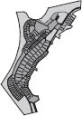
For what is the single-family home suburban development, if not the urban typology most emblematic of the freedom to own land, of mobility, and of the right to access space? (fig. 5.10.4)
The flight of the middle class from the cities to the “protective” walls of suburbia gains new meaning in the context of the occupation of the West Bank. In a daunting reversal, the act of retreat from the “conflicts” of the city has become an intrusive act, perpetuating a conflict on a much larger scale. The adaptability and flexibility of the suburban typology makes it an effective tool of territorial control that can be implemented in a range of scales, to comprise a few homes or an entire neighborhood, and flexible enough to conform to the specific topographical conditions of different sites.
Moreover, the social homogeneity that is characteristic of this suburban population serves the political aim of the occupation: that of acting as a single, unified front against the local hostile population. The monotonous architecture of the settlement typology, which reflects this homogeneity, turns urban sprawl in the West Bank settlements into a well-coordinated and fully planned strategic project to effect a maximum level of territorial control, using the most rudimentary element of domestic space: the single-family detached house.
2 Eyal Weizman, “The Subversion of Jerusalem’s Sacred Vernaculars,” in The Next Jerusalem: Sharing the Divided City, ed. Michael Sorkin (New York: Monacelli Press, 2002), 132.
3 Yehezkel Lein and Eyal Weizman, Land Grab: Israel’s Settlement Policy in the West Bank (Jerusalem: B’tselem, 2002).