1815
Mount Tambora Eruption
The so-called Pacific Ring of Fire is a hemispheric-sized zone of extensive earthquake and volcanic activity extending along tectonic plate boundaries from South America north to the Aleutian Islands, then back south past Japan and Indonesia, and then eventually to New Zealand. Geologic activity along the Ring of Fire is spurred by collisions among the Pacific plate and several others, and is especially intense where oceanic crust is subducting and melting underneath continental plates. Among the most active collisional zones is a long, curving stretch of crust extending from Myanmar to Papua New Guinea, where the Indian and Australian plates are rapidly subducting under part of the Eurasian plate.
Indeed, the most powerful volcanic eruption yet recorded in modern history occurred in this region at Mount Tambora, on April 5–11, 1815. Tambora was a 14,000-foot (4,300-meter) mountain prior to the eruption, but was reduced by a third to its current height of 9,350 feet (2,850 meters). The eruption is classified as having had a Volcanic Explosivity Index of 7 (out of 8), the kind of event that only occurs once every 500 to 1,000 years. The sound of the explosions was heard more than 1,500 miles (2,400 kilometers) away, and ash covered the ground as far away as 800 miles (1300 kilometers).
The eruption of Mt. Tambora instantly killed about 10,000 people and led to the indirect deaths of perhaps 100,000 more because of subsequent famine and disease in the region. The volcanic plume injected enormous amounts of ash and volcanic gases into the stratosphere, which had a rapid cooling effect on the global climate (1816 was known as “the year without a summer” for much of the world). Crops failed for several years in many regions, causing more loss of life because of famine and disease, including outbreaks of typhus and cholera.
Tambora’s 1815 event is the most deadly volcanic eruption so far in recorded human history. The volcano experienced another minor eruption around 1880 and is still active today. Diligent monitoring and prohibitions by the Indonesian government on development close to the summit are ongoing, in an effort to try to protect the lives of the nearly 10 million people who now live within the broader zone affected by the 1815 eruption.
SEE ALSO Plate Tectonics (c. 4–3 Billion BCE?), Cascade Volcanoes (c. 30–10 Million BCE), The Andes (c. 10 Million BCE), Pompeii (79), Krakatoa Eruption (1883), Mount St. Helens Eruption (1980), Volcanic Explosivity Index (1982), Mt. Pinatubo Eruption (1991), Sumatran Earthquake and Tsunami (2004)
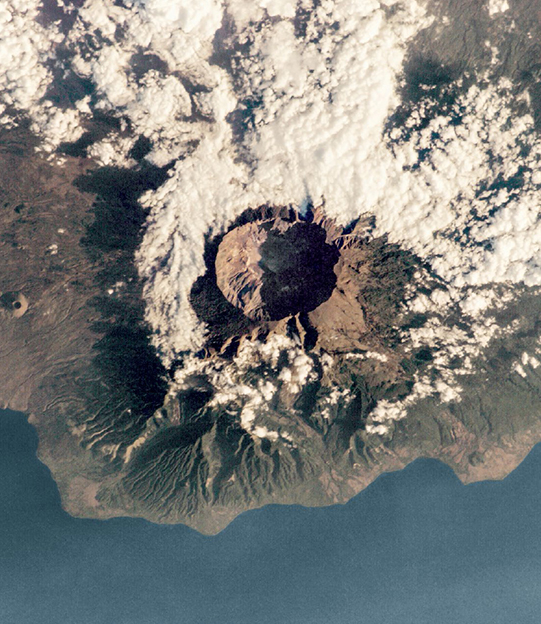
A 2005 photo of the volcanic island and caldera of Mount Tambora, Indonesia, from the International Space Station. In April 1815, Mount Tambora was the site of the most powerful volcanic explosion in recorded history.