1947
Weather Radar
Catastrophic natural storms like the hurricane that destroyed Galveston, Texas, in 1900 or the devastating tri-state tornado of 1925 were partly as disastrous as they were because of the lack of significant advance warning or of active tracking/monitoring of those kinds of meteorological events. With the advent of airborne remote sensing in the late nineteenth and early twentieth centuries, it became possible to monitor some kinds of storms from balloons, airships, or airplanes. However, such deployments were sparse and expensive, and often couldn’t yield reliable information on where it was raining or snowing because the observers were “clouded out.” Meteorologists needed a way to see through the clouds to truly track the storms.
That way would come with the advent of radar, an acronym that stands for “RAdio Detection And Ranging.” Active radar systems broadcast radio waves in a certain direction using an antenna and then measure how much of that radio energy gets reflected back to a receiver that uses the same antenna. The technique was pioneered in the 1930s and then significantly enhanced for use in World War II as a way to detect and track enemy airplanes and ships. Radar technology was found to have many other important military and civilian applications, one of which is weather forecasting.
Thick clouds are opaque to visible light, but the tiny aerosol particles that they are made of are transparent to radio waves. However, much larger raindrops, sleet, and snow particles that form within clouds are not transparent to radio waves. Thus, when a radar system sends a pulse into a cloud, much of that signal passes right through, except for a fraction that bounces off rain, snow, or sleet and gets reflected back to the radar antenna. Radar can thus “see” weather that human eyes cannot.
Once the technology was declassified, the first dedicated commercial weather radar stations began operation in 1947 under the control of the US Weather Bureau (now the National Weather Service). The first station was commissioned in Washington, DC, and was quickly followed by several dozen more stations around the country, deployed to help provide warnings and monitoring of extreme weather events. The systems were enhanced over time and expanded in coverage, and today a global network of advanced weather radar stations provides critical data for forecasting, aviation, shipping, and weather-related academic research.
SEE ALSO Airborne Remote Sensing (1858), Galveston Hurricane (1900), Tri-State Tornado (1925), Geosynchronous Satellites (1945), Cloud Seeding (1946), Weather Satellites (1960), Earth Science Satellites (1972)
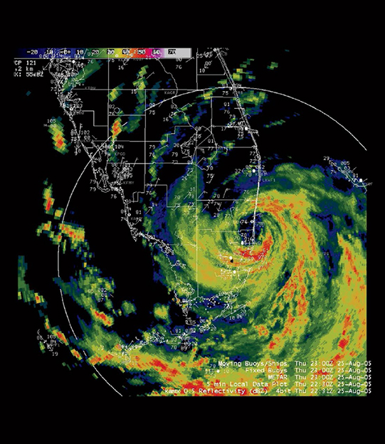
Weather radar map of rain bands in Hurricane Katrina as it approached the southeastern coast of Florida on August 25, 2005.