1993
Oceanography from Space
Kathryn D. Sullivan (b. 1951)
The idea of flying an airplane or satellite over continents or islands to study and monitor their geology, weather, plant health, patterns of land use, and so forth seems like a straightforward and reasonable application of modern sensors and Earth science capabilities. But remote sensing of the oceans? What could there be to see?
Plenty, it turns out. The first satellite dedicated to remote sensing of the oceans was a 1978 NASA mission called Seasat, launched as a pilot mission to demonstrate that useful information about the oceans could be obtained from space. Seasat operated for only 106 days but demonstrated the ability to measure sea-surface winds, temperatures, wave heights, internal waves, and sea ice features.
The success of the brief Seasat demonstration mission helped to justify astronaut-tended oceanographic observations from the NASA Space Shuttle, which began flying in the 1980s. An important participant in these efforts has been oceanographer and astronaut Kathryn Sullivan, who flew on three shuttle missions in 1984, 1990, and 1992 and who participated in or led a number of important experiments to study the Earth from space. Sullivan had participated in oceanographic ship expeditions for her doctoral research, studying the Mid-Atlantic Ridge, the Newfoundland Basin, and fault zones off the Southern California coast. After leaving NASA, Sullivan was able to promote significant advances in the study of oceanography from space as the Administrator of the National Oceanic and Atmospheric Administration (NOAA) from 2013 to 2017.
Perhaps the largest advance in oceanography from space came in 1993, however, when the first large-scale oceanographic research satellite, a joint NASA–French Space Agency mission called TOPEX/Poseidon, went into operation. That mission, which operated until 2006, provided the first continuous global coverage of ocean surface topography and revealed the previously unknown patterns of ocean circulation that—because the oceans hold most of Earth’s heat from the Sun—are the driving force of the climate on our planet. Follow-on oceanography satellite missions like the Jason series, as well as additional astronaut observations from the Space Shuttle and the International Space Station, continue to dramatically expand our knowledge of the oceans.
SEE ALSO Earth’s Oceans (c. 4 Billion BCE), Airborne Remote Sensing (1858), Exploring the Oceans (1943), Humans in Space (1961), Earth Science Satellites (1972), Geology on the Moon (1972), Ocean Conservation (1998)
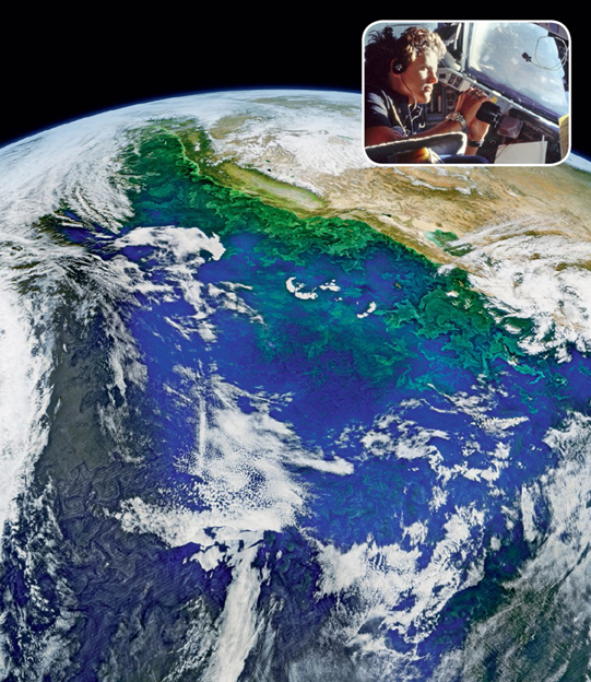
Main image: A 2016 composite image, from NASA’s Suomi ocean science satellite, of the distribution of phytoplankton (green) in the California Current. Inset: Astronaut Kathy Sullivan views the Earth through the Space Shuttle Challenger’s windows in 1984.