c. 8000 BCE
The Great Lakes
Lakes are critical storehouses of most of the world’s freshwater supply. The world’s single largest freshwater lake, Lake Baikal in Siberia, has about the same surface area as the relatively small U.S. state of Maryland but holds almost 20 percent of the world’s freshwater supply by volume. A comparable volume of water is stored within the five large interconnected freshwater lakes in North America known collectively as “The Great Lakes.” Lakes Huron, Ontario, Michigan, Erie, and Superior combined are the largest group of freshwater lakes by surface area in the world (comparable in area to the U.S. states of Pennsylvania and Ohio combined), and the second largest group in terms of volume.
Many geologists believe that the Great Lakes formed along zones of continental weakness associated with two ancient rifts in the North American plate; the first was a mid-continental rift that formed around 1 billion years ago, and the second was the St. Lawrence rift that formed around 570 million years ago. Neither rifting episode was extensive enough to split North America into separate continents, but they did create faults and deep valleys that became more susceptible to erosion. Indeed, many of these valleys were widened and deepened by repeated episodes of glaciation during the intervening ice ages. As the most recent continental glaciers began to retreat around 12,000 years ago, their meltwater began to fill these basins. By about 10,000 years ago, the remains of the last major North American glaciation took on the form of the Great Lakes as we see them today.
The Great Lakes are essentially inland seas, with rolling waves, strong currents, and lake-generated winds. They cover a large enough area to have significant local weather and climatic impacts on their surroundings, especially downwind. Among the most famous are winter “lake effect” snowstorms. Cold prevailing westerly winds cross the lakes and pick up warmer evaporating water vapor, and when that vapor passes over colder land to the east, it condenses out as snow, often in concentrated bands or streamers that dump epic amounts of snow (3 to 6 feet, or 1 to 2 meters, per day!) over small areas.
SEE ALSO The Caspian and Black Seas (c. 5.5 Million BCE), The Dead Sea (c. 3 Million BCE), Lake Victoria (c. 400,000 BCE), End of the Last “Ice Age” (c. 10,000 BCE), Beringia Land Bridge (c. 9000 BCE)
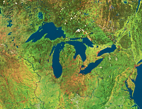
NOAA weather satellite mosaic of northeastern America, showing the five Great Lakes (left to right): Lake Superior, Lake Michigan, Lake Huron, Lake Erie, and Lake Ontario.