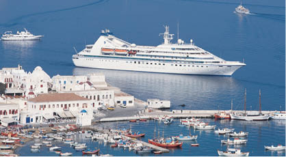
The Greek Isles

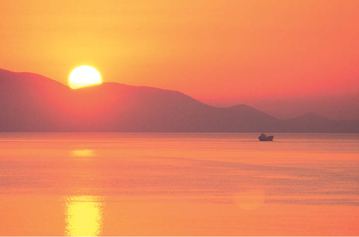
The only way to see the Greek isles is slowly, by boat. At least that’s what Cary Grant told Doris Day in the 1962 comedy, That Touch of Mink, when he likened these islands to fine paintings. “You mustn’t rush up to them,” he said. Anyone who has stood at a ship’s rail and watched the sun rise above a Greek isle will know exactly what he meant. A seaborne arrival, as the morning sun warms the terraced hillsides and whitewashed houses, is a travel experience of unsurpassed romance.
Map of the Greek Isles
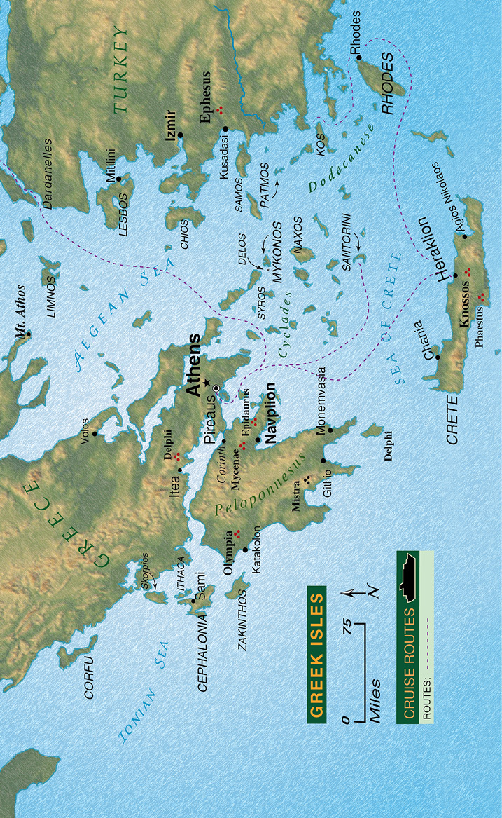
Greece has more than 2,000 islands, comprising about one-fifth of the country’s total land area, yet only some 200 are inhabited. When the Greek government announced a plan in 1995 to resettle some of its uninhabited islands, the response – both domestic and foreign – was overwhelming. Thousands of people from all walks of life sought to move to one of the many islands left abandoned after World War II when their inhabitants emigrated in droves to the cities. Whether or not Greece’s repopulation plan is successful, it’s obvious the allure of the Greek isles is as strong as ever.
For general information and travel tips on Greece, please see pages 258 and 259.
The Cyclades, comprising about 220 islands in total, lie spread across 1,000 square miles of the Aegean Sea. They are quintessential Greek islands, with their charming fishing harbours and seaside villages. Box-shaped houses climb the hillsides and dome-roofed chapels cling to cliffsides, their dazzling whiteness appearing in stark contrast against the deep blues of the sky above and the sea below.
Most popular of the Cyclades are the tourist-oriented islands of Santorini and Mykonos, the latter lying close to uninhabited Delos – a centre of Cycladic (Greek for circular) culture in ancient times, with the other islands forming a rough circle around it.
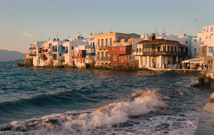
The whitewashed, sunbaked buildings of Little Venice in Mykonos.
Mykonos (Mikonos)
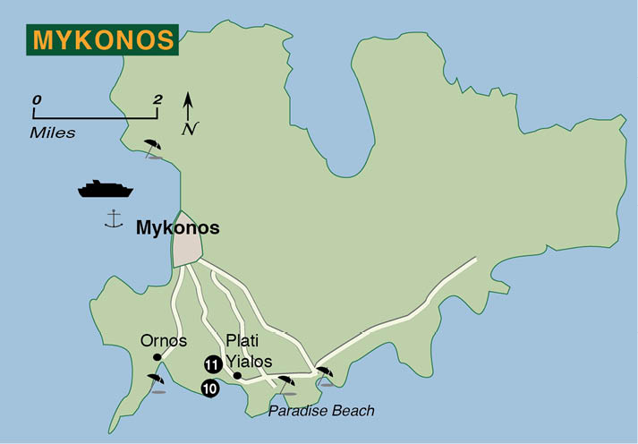
This arid island, 35 square miles in size, is the most cosmopolitan of the Cyclades. Although extremely popular with tourists, Mykonos has retained a Cycladic charm with its whitewashed houses and hilltop windmills. Shops, cafés and tavernas line the town’s waterfront area while serious shoppers will delight in wandering the town’s winding backstreets.
Map of Mykonos Island
1. Platia Manto – Originally designed to disorient marauding pirates, these twisting alleyways are now lined with boutiques frequented by the rich and famous. Jacqueline Onassis and Elizabeth Taylor are among the famous women who have shopped at Galatis on the town’s main square (Platia Manto), also referred to as Taxi Square.
Map of Mykonos Town
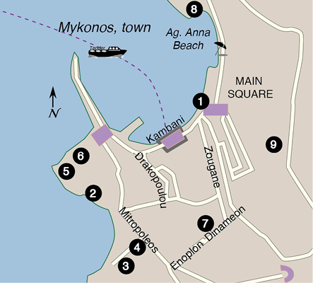
2. Little Venice – a neighborhood south of the main harbour, is where you’ll find local artwork and handicrafts.
3. Roman Catholic Cathedral – The waterfront buildings in this section are a reminder of the island’s Venetian period, as is this cathedral, its entrance hall bearing the coat of arms of the Ghisi family who took over Mykonos in 1207.
4. Greek Orthodox Cathedral – Located next door is the Greek Cathedral. Nearby, on a promontory overlooking the sea is;
5. The Church of Paraportiani – its cluster of whitewashed chapels a much-photographed sight.
6. Folklore Museum – A short distance away is this museum housed in the 300-year-old house of a former sea captain.
7. Aegean Maritime Museum – Located near the south end of town.
8. The Archaeological Museum – at the north side of Ag. Anna Beach.
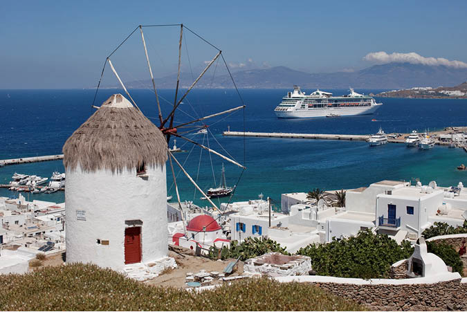
9. Working windmill – the much photographed windmills can be admired on the east side of town. More windmills stand on a headland south of Mykonos town.
The island’s south coast boasts a string of beautiful beaches, which are a short taxi or bus ride from the town.
10. Psarou – one of the finest (and busiest) of these beaches, features restaurants and a variety of watersports.
11. Plati Yialos – also has restaurants and is popular with families. The beaches lying to the east – Paranga, Paradise, Super Paradise and Elia – are designated nude beaches, and can be reached by boat from Plati Yialos or by road from Mykonos town.
Delos – The smallest of the Cyclades, this tiny island was of great importance in ancient times, when its temple of Apollo held the treasury of the Delian League – a confederation of maritime states led by Athens. Today the island group’s administrative centre is on Syros, but its historical heart remains on Delos – the mythical birthplace of Apollo.
According to Greek legend, Zeus’s lover Leto was cursed by his jealous wife. A pregnant Leto wandered the earth until the god Poseidon took pity on her and gave her a place to rest by anchoring the island of Delos with four diamond columns. There Leto gave birth to Zeus’s children – a girl named Artemis and a boy named Apollo, who became important Greek gods.
Council members of the Delian League, formed to finance a war against Persia, would meet on the politically neutral island of Delos and contribute funds, troops and ships to the league. Its treasury was moved from Delos to the Athenian Acropolis in 454 BC but the island continued to prosper, becoming the site of a thriving slave market in the 2nd century BC. Sacked by Mithridates VI of Pontus (modern Turkey) in 88 BC, Delos never recovered and was abandoned near the end of the 1st century BC.
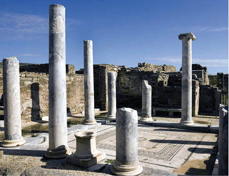
The ancient ruins on Delos.
Excavation of the site began in the 1870s and today the uninhabited island is visited by day trippers arriving solely to see its ancient ruins, which include the small sanctuary of Dionysus (dating to 300 BC), a restored temple to the goddess Isis, and the famous Terrace of the Lions, carved from marble in the 7th century BC.
The largest of the Cyclades, Naxos is ringed with beautiful beaches and traversed with fertile valleys where olive trees and grape vines thrive in the fertile soil. An island steeped in Greek mythology, Naxos was once a centre of worship of Dionysus and a member of the Delian League. The town of Naxos (Hora) runs from the harbour up a hillside, its narrow winding lanes lined with stone houses and leading to a Venetian castle. White marble and granite have been quarried on Naxos since antiquity, and monuments from various periods can be found throughout the town, including fine Byzantine churches and the castle with its tower and battlements. The local archaeological museum in Naxos also contains some notable exhibits.
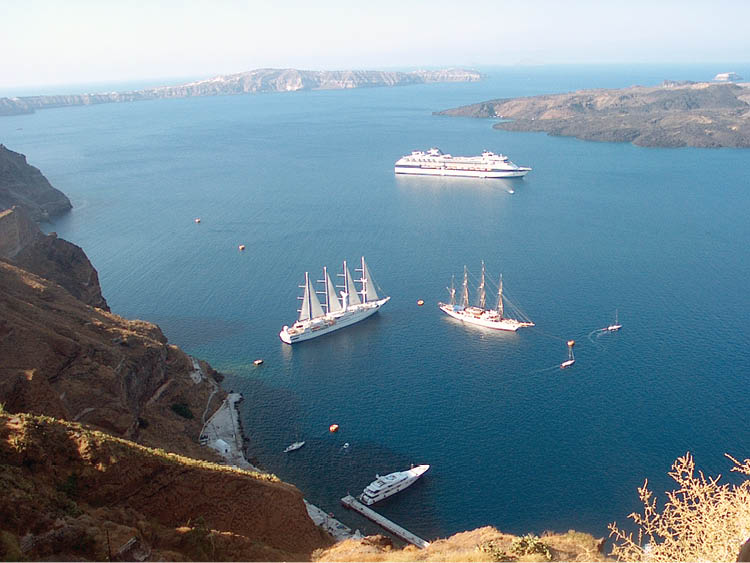
Fira town is perched high above the harbour on Santorini.
Santorini (Thira)
Myth and modern science meet on the island of Santorini, believed by many to be the lost kingdom of Atlantis, which was destroyed by a volcanic explosion in about 1500 BC and described by Plato. Crescent-shaped Santorini’s stunning setting seems to support this myth. Set on the exposed rim of a submerged volcano, Santorini’s harbour is a flooded crater with the two inner islands emerging from lava domes.
Map of Santorini
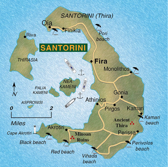
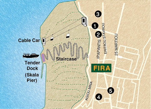
Cruise ships anchor in this watery caldera usually near the old port of Skala Pier and tender passengers ashore to the base of an idyllic clifftop town of Fira where a switchback staircase ascends the crater wall. The town can be reached on foot, by donkey, by cablecar or by motorcoaches used for shore excursions. It takes about 45 minutes to reach the top on foot and although free, you will have to dodge the donkies. Taking the cable car or the donkies costs about € 5 ($7-$8). Whatever your chosen mode of ascent, the view from above is spectacular. Passengers booked on a ship’s shore excursion are usually taken by tender to the new port of Athinios.
Across the bay from Fira lies the quiet island of Thirasia, a fragment of the caldera’s rim that was once joined to the main island until an eruption in 236 BC. Dotting the bay are the smaller Burnt Islands, which rose from the caldera in subsequent eruptions. Palia Kameni emerged in 196 BC, and Nea Kameni last erupted in 1925. In the past, a reliable warning of an imminent eruption occurred when the surrounding sea turned a milky colour due to an increase in underwater sulphur emissions.
Located about 1300 feet above sea level, Fira is a fashionable resort, its terraced streets of whitewashed buildings lined with chic shops and restaurants, its numerous domed churches still prominent amid the tourist attractions.
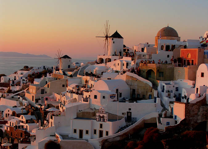
Sunset in the village of Oia at the north end of Santorini.
The village of Oia at the north end of the island (which can be reached by local bus) is a haven for artists, their original works sold in the array of galleries lining streets that are wide enough for pedestrians but not cars. The view of the cauldron and Santorini from here is quite beautiful.
Before the catastrophic eruption of c. 1500 BC, Santorini was colonized by Minoans from Crete. Archaeological digs indicate these people heeded the warning earthquakes and abandoned the island before the massive explosion. The island was next settled by Phoenicians, followed by Laconians from the Peloponnese peninsula who estalbished a new centre on the island’s east coast under their leader Thira.
From the Middle Ages onwards, the island was called Santorini after St. Irene, protector of the island. The Greek god of fertility and wine, Dionysus, is also associated with Santorini where wine grapes thrive in the volcanic soil.
1. Cablecar – This ride to Fira takes about five minutes and gives a great view of your ship and the islands.
2. Archaeological Museum – Near the cable car ticket office at the top is this museum which displays artefacts from ancient Thira.
3. Roman Catholic Cathedral – A private museum is housed in a restored mansion near this cathedral.
4. Greek Orthodox Cathedral – More churches, including this one are situated a few blocks south of the cable car office.
5. Platia Theotokopoulou – is the town’s main square, where tourist services are located.
Map of Fira
At the south end of the island, near Akrotiri, is the ancient Minoan site. Still under excavation, it was discovered in the late 1960s by Professor Spyros Marinatos, who discovered an extensive ancient city preserved for 35 centuries beneath tons of volcanic ash. Streets of multi-storeyed warehouses and homes, their walls decorated with vivid wall paintings, were revealed as the ash was cleared away, but the absence of skeletons indicated there had been a mass evacuation prior to the explosion. Geological evidence indicates the island was racked beforehand by earthquakes, ample warning for the island’s residents. In 2007 the cruise ship MS Sea Diamond hit a rock and sank near the port of Athinios.

Busy Red Beach near Akrotiri.
Most of the beaches on Santorini are black, due to the fallen volcanic ash but there is also a well-known red beach near Akrotiri. Although busy, the beach has good swimming and snorkeling with views to anchored yachts.
Map of Crete
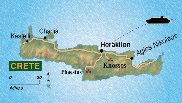
Crete
A mountainous island of deep gorges and farm-filled valleys, Crete’s long history is one of invasion and resistance. In ancient times, one of the world’s earliest civilizations thrived on the island of Crete. Called Minoan for the legendary King Minos, its great palaces were adorned with colourful murals and enormous clay pottery.
Minoan habitation of Crete began in about 3000 BC. The island’s forests supplied wood for boat building, and the residents of Crete engaged in seagoing trade. Their island lay only 400 miles from the northern shores of Egypt, where an advanced civilization influenced the cultural development of Crete. Neolithic village life evolved into an urban society centred around great palaces. Minoan art flourished, portraying animals with a joyful fluidity of movement.

A quiet square near Agio Titos.
When Dorian Greeks settled on the island several centuries after the collapse of the Minoan civilization, they established dozens of city-states, with Knossos emerging as one of the most powerful. A centre of trade, the island became a pirate haven until conquered by the Romans in 68 BC. The Byzantines were next to rule Crete, followed briefly by Arabs before the island was reconquered by the Byzantines in 961.
Next to rule the island were the Venetians, who built a wall around Heraklion (then called Candia) to defend this important trading port from pirates. When the Ottoman Turks over-ran the island in 1648, the garrison at Heraklion fought off the invaders for 21 years before surrendering.
The statesman Eleutherios Venizelos, born in Crete and educated in Athens, returned in 1896 to play a prominent role in the island’s insurrection against Turkish rule. Turkey, at the intervention of European powers, was eventually forced to evacuate, and in 1908 Crete proclaimed its union with Greece.
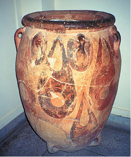
Minoan vase dating from 1700 BC in Archaeological Museum.
Crete came under invasion once again, during World War II, when British and Greek forces on the island were overwhelmed by a German airborne invasion. The German troops occupying the island eventually surrendered to the British navy in late 1944.
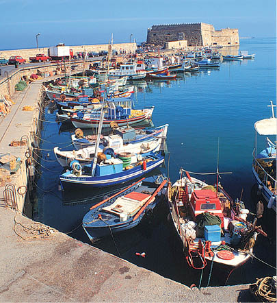
Iraklion’s Old Harbour.
Famous Cretans include the 16th-century painter El Greco, and Nikos Kazantzakis, author of Zorba the Greek. The singer Nana Mouskouri was born in Chania, on Crete’s north coast, shortly before the Second World War, and her childhood recollections include the excitement of the olive harvest when she dipped her mother’s freshly baked bread into extra virgin olive oil, made from the first pressing and flavoured with fresh herbs grown in the mountains.
