
8 Huckleberry Mountain Lookout
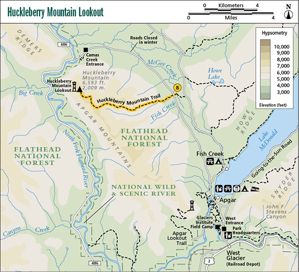
A day hike from Camas Creek Road to Huckleberry Mountain Lookout, 6.0 miles (9.5 km) one-way.
Elevation gain: 3,403 feet
Maximum elevation: 6,593 feet
Topo maps: McGee Meadow, Huckleberry Mountain
Finding the trailhead: Follow Camas Road northwest out of Apgar. The trailhead is marked on the road, about 6 miles northwest of Apgar, on the left. Trailhead GPS: 48.596565 / –114.038397
The Hike
This trail has a high density of grizzly bears at times, and the park service sometimes closes the trail when bears are concentrating their use in the area.
The trail begins near McGee Meadows and climbs steeply up the north bank of McGee Creek through forest before emerging above the trees. The trail continues to climb until it reaches the ridgeline and then turns north, following the crest of the Apgar Mountains for 1.5 miles to the manned lookout.
The slopes below the lookout were burned by a wildfire in 1967 and again by the 2001 Moose Fire. The burn site has been colonized by dense stands of lodgepole pines locally known as “doghair.” The cones of lodgepoles are serotinous, which means that they remain sealed until the high temperatures of fire melt the seal around the cone, allowing them to open and release the seeds. A few huge larch trees survived the fire by virtue of their thick bark, which peels away from the trunk as it burns, thus protecting the living cambium under the bark from fire damage. The seedlings of both larch and lodgepoles require the open sunlight provided by burned areas to germinate and are known as “fire-adapted” species. From the lookout, the uninterrupted forests of the North Fork Valley stretch away to the foot of the snowcapped Livingston Range, which dominates the eastern skyline.
—Matt Cutler
Miles and Directions
0.0Trail sign.
4.5Turn north, following the crest of the Apgar Mountains.
6.0Arrive at Huckleberry Mountain Lookout.