18 Northern Highline
An extended backpack from Granite Park to Fifty Mountain Campground, 11.9 miles (19 km) one-way.
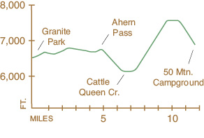
See map on 17 The Garden Wall
Elevation gain: 1,910 feet
Elevation loss: 1,780 feet
Maximum elevation: 7,440 feet
Topo map: Ahern Pass
Finding the trailhead: Granite Park Chalet can be reached via Logan Pass or the Loop, the large hairpin turn on Going-to-the-Sun Road, about 7 miles west of the pass (Trailhead GPS: 48.754975 / –113.80046). Fifty Mountain Campground is accessed via Goat Haunt Ranger Station, which is reached by ferry from Waterton townsite or by trail along the western shore of Waterton Lake. GPS coordinates: 48.85250 / –113.86149
The Hike
The northern section of the Highline Trail is accessible only to hikers on extended trips of more than one night. It runs from Granite Park Chalet to Fifty Mountain Campground, connecting the Garden Wall Trail and the Many Glacier complex with trails out of Goat Haunt on Waterton Lake. The trail stays high in the subalpine country throughout its entire length, and sublime views can be had at any point along the trail. The forests below were burned in the 1988 Kootenai complex of fires and in 2003 during the Trapper Creek Fire, which cleared the conifers to make way for a profusion of wildflowers.
The trail begins by passing around the east side of the chalet and quickly winds around a meadowy spur ridge and out of sight. Meadows along the trail contain glacier lilies, mountain asters, shooting stars, and Indian paintbrushes at different times of the summer. To the west the peaks of the Livingston Range are constant companions to the hiker as the trail runs to the north. To the southwest lies Heavens Peak, while Longfellow Peak is the large mountain farther to the north and behind it. Several miles out from the chalet, the trail rounds a rocky knob and turns eastward briefly, hugging the cliff wall. A persistent snowdrift in this area makes early-season travel on this section hazardous, if not impossible. The rocky basin beyond is prime habitat for mountain goats and hoary marmots, who graze together in the meadows below the cliff walls.
As the trail reaches the north end of the basin, another trail cuts off to the east, traveling 0.4 mile to the low saddle of Ahern Pass. From the vicinity of the pass, the Ahern Glacier can be seen clinging to the southeast face of Ipasha Peak, with waterfalls cascading down the cliff face below it into Helen Lake. A mountaineers’ route exists to the Iceberg Notch, immediately above the pass; and from the notch seasoned climbers may tempt the fates by passing along a narrow goat trail that hugs the face of Iceberg Peak above several thousand feet of vertical exposure.
Continuing northward from Ahern Pass, the Northern Highline begins a long, gradual descent through open forests of subalpine firs dotted with wildflowers toward Cattle Queen Creek. A hazardous snow-slip exists where the trail crosses this creek and may not melt away until late July. Proceed with caution while crossing snowy slopes, as slipping or falling through spells certain injury and may even be fatal. The Cattle Queen Valley is rather brushy, with forbidding walls on both sides. From this creek the trail begins a long and steady ascent, covering almost 2,000 feet in 4.0 miles. The trail continues upward beyond the timberline, winding through rocky meadows populated with ground squirrels and songbirds.
A mile before reaching Fifty Mountain Campground, the trail reaches its highest point as it passes over a rocky saddle in a scree-slope wasteland. The snowcapped peaks of the Livingston Mountains stretch away as far as the eye can see to the west and south, while Mount Kipp overlooks the trail to the east. The rocky ridge with serpentine snowfields on its face is Trapper Peak, with pyramid-shaped Mount Geduhn behind it to the south. The horn peak to the south of Geduhn is Anaconda Peak. The saddle also offers a fine vantage point for viewing the Kootenai Complex burn of 1998. This fire was started by at least six lightning strikes and burned in a patchy mosaic across the timberline woodland atop Flattop Mountain to the west.
Just north of this saddle, a spur trail ascends steeply to a notch that overlooks Sue Lake and the glacier-clad summits of the Mokowanis River Valley. The main trail descends into the forest fringe that occupies the edge of the high shelf below, where it enters Fifty Mountain Campground. The Kootenai Complex Fire burned into the campground in 1998, clearing the area of subalpine firs. Please do not feed the wildlife, as feeding encourages the animals to scavenge for human refuse instead of foraging for their natural foods. Deer and mountain goats are particularly fond of salt, which is lacking in their high-altitude diets. Secure all sweaty clothing and gear out of their reach, and use the pit toilet provided at the campground when nature calls. Trails from the campground descend to the west to Flattop Mountain and to the north to Goat Haunt Ranger Station.
Miles and Directions
0.0Trail sign, Granite Park Chalet.
0.2Junction with Swiftcurrent Pass Trail. Stay left for the Northern Highline.
0.5Junction with Granite Park Campground Trail. Stay right for the Northern Highline.
4.5Junction with Ahern Pass Trail (0.4 mile, easy). Stay left for Fifty Mountain.
6.5Trail reaches its lowest elevation as it crosses Cattle Queen Creek.
10.9Junction with Sue Lake Overlook Trail (0.4 mile, maximum elevation 7,700 feet, strenuous). Stay left for Fifty Mountain.
11.9Fifty Mountain Campground.