26 Scenic Point
A half-day hike from Two Medicine Road to Scenic Point, 3.8 miles (6 km) one-way; or a backpack from Two Medicine Road to East Glacier, 10.0 miles (16 km) one-way.
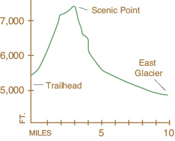
Elevation gain: 2,242 feet
Maximum elevation: 7,522 feet
Topo map: Squaw Mountain
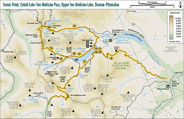
Finding the trailhead: The trail departs from a marked trailhead on the Two Medicine Road, approximately 11.5 miles west from its junction with MT 49. Trailhead GPS: 48.485137 / –113.3615.
The Hike
This trail is most commonly taken as a short hike from the Two Medicine Road to Scenic Point and back. Through-hikers bound for East Glacier must purchase a Blackfoot conservation permit at a local ranger station, as the route crosses reservation lands. The trail begins immediately off the Two Medicine Road just before an old water tank on the east bank of Appistoki Creek, climbs along the creek past Appistoki Falls, and then ascends high on the arid valley wall above the creek. Looking up the desolate creek valley from this hillside, Mount Henry raises its forbidding head to the south. The trail climbs to the summit of the windblown dome known as Scenic Point. On a clear day you can see out across the high plains all the way to the Sweetgrass Hills, some 100 miles distant. Looking to the west, Dawson Pass is clearly visible, with jagged peaks surrounding it. Only the most hardy plants grow in the arid, windswept environment on top of Scenic Point, and the poor growing conditions cause a stunted growth form in these plants.
For hikers continuing to East Glacier, the trail drops into a bowl filled with twisted trees before descending onto open slopes and crossing Fortymile Creek. The trail continues across the open east slope of the Front Range, finally descending into the trees and crossing another creek before leaving the park. The trail continues eastward, having a lower maintenance status as it leaves the park, as it crosses a low hillock on its way to a primitive dirt road. After reaching the road, keep a sharp eye out for trail markers, as the trail crosses several jeep roads in this area. The trail emerges from the woods onto a gravel road, which reaches its terminus just north of the Glacier Park Lodge in East Glacier.
Miles and Directions
0.0Mount Henry trailhead sign, near water tank.
0.5Junction with Appistoki Falls Trail (200 yards). Stay left for Scenic Point. Trail ascends the Appistoki Valley, then climbs to Scenic Point.
3.8Scenic Point.
10.0Trail reaches gravel road behind the golf course in East Glacier.