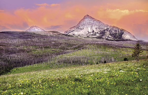
Triple Divide Peak Licensed by Shutterstock.com
31 Medicine Grizzly Lake—Triple Divide Pass
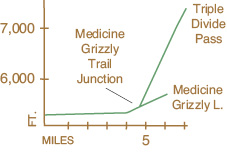
A long day hike or short backpack from Cut Bank Ranger Station to Medicine Grizzly Lake, 6.0 miles (9.5 km) one-way; or from Cut Bank Ranger Station to Triple Divide Pass, 7.2 miles (11.5 km) one-way.
See map on 30 Cut Bank Creek
Elevation gain to lake: 540 feet
Elevation gain to pass: 2,380 feet
Maximum elevation: 7,397 feet (Triple Divide Pass)
Topo maps: Cut Bank Pass, Mount Stimson
Finding the trailhead: Take US 89 to its junction with Cut Bank Creek Road, 17.0 miles north of East Glacier. Drive 4.0 miles over this improved gravel road past the ranger station to the backcountry parking area. The trail runs west from this parking lot. Trailhead GPS: 48.602452 / –113.38376
The Hike
The Triple Divide Pass Trail begins at the Cut Bank Ranger Station and follows Cut Bank Creek for almost 4 miles before ascending the Atlantic Creek Valley. Both Medicine Grizzly Lake and Triple Divide Pass may be visited on a long day hike, while a campground near the confluence of Atlantic and Cut Bank Creeks provides overnight facilities for backpackers. Triple Divide Pass connects the Cut Bank Creek Trail with the Red Eagle Lake Trail, allowing access for hikers on extended trips into the St. Mary drainage.
The trail begins just beyond the ranger station on a well-maintained gravel road and crosses low-elevation meadows before entering an open forest of lodgepole pine and Douglas fir. The trail climbs imperceptibly as it follows the north bank of the creek, and openings in the trees reveal a small, rocky canyon as the creek passes below the foot of Bad Marriage Mountain. The process of frost cracking is constantly at work on this mountain. During the winter water seeps into cracks in the rock. As the water freezes, it expands, creating a wedge that separates large chunks of rock from the parent material. The huge aprons of dislodged boulders below cliff faces, called talus slopes, are a testimony to the powerful impact of this process on local landforms. Game trails can be seen crossing the talus slope at the base of this mountain, which is a good place to look for bighorn sheep.
Triple Divide Peak Licensed by Shutterstock.com
About 4 miles up the trail, at the junction at Atlantic Creek, the Triple Divide Trail climbs gently to the north, passing through the Atlantic Creek Campground. Two-thirds of a mile from the junction, the trail forks, with the left fork following the valley floor for 1.4 miles through beargrass-studded parklands to Medicine Grizzly Lake. The right fork rises steadily along the north wall of the valley, climbing high above Medicine Grizzly Lake. Across the valley an unnamed lake lies in a hanging cirque embedded in the north face of Medicine Grizzly Peak. The trail continues its pleasant grade upward without a single switchback, passing tiny waterfalls and emerging into a meadowy bowl below the pass.
Triple Divide Pass derives its moniker from the peak of the same name that overlooks the pass to the west. Water flowing from the various sides of this peak will eventually reach the Atlantic, Pacific, and Arctic Oceans. An alpinists’ route to the peak’s summit crosses the steep talus bowl to the south and climbs the second of two couloirs, which pierces the Atlantic Valley headwall to reach a flat saddle. From this point it is an easy scramble up the south slope of the peak to the summit.

Keep an eye out for marmots near Triple Divide Pass. Licensed by Shutterstock.com
Wildlife is abundant in the vicinity of the pass. Hoary marmots, chipmunks, and both golden-mantled and Columbia ground squirrels make their homes in the talus surrounding the pass. Bighorn sheep are frequently sighted on the surrounding slopes. Herds of bighorn are segregated by sex—rams and ewes are rarely found in the same herd during the summer months. These animals begin rutting in September, and the thunderous cracks of colliding rams may be heard as early as late August. Looking northward from the pass, Norris Mountain dominates the head of the valley, while Split Mountain rises on its northern perimeter. The south faces of the peaks surrounding Little Chief Mountain can be seen in the background.
Miles and Directions
0.0Trail sign. Trail climbs gently, following the North Fork of Cut Bank Creek.
0.1Junction with old chalet road. Stay right for Medicine Grizzly Lake and Triple Divide Pass.
3.9Junction with Triple Divide Trail. Turn right for the pass and Medicine Grizzly Lake. Trail begins gradual ascent of Atlantic Creek Valley.
4.3Atlantic Creek Campground.
4.6Junction with Medicine Grizzly Lake Trail. Turn left for Medicine Grizzly Lake (1.4 miles). Stay right for Triple Divide Pass. Trail climbs north side of Atlantic Creek Valley.
7.2Triple Divide Pass.
Connecting Hikes
A short spur runs from the Two Medicine South Shore Trail to Paradise Point, a total distance of 0.6 mile. The hike is an easy one, over fairly flat ground, that passes through fir forest past several beaver ponds on the way to its destination on the lakeshore.
Another spur trail from the South Shore Trail runs up a ravine to Aster Falls. The total distance from the east boat dock to the end of the trail is 1.9 miles. Above the falls is an open meadow known as Aster Park, which affords a pleasant spot for a picnic.
The Cut Bank Pass Trail connects Pitamakan Pass to the Nyack Valley, allowing east–west crossings of the Continental Divide in the park’s southern areas. This connector is very steep and thus is not recommended for horse parties or the fainthearted.
A trail running south from Rockwell Falls to Paradise Park is still shown on some old maps. This trail is not in existence, however, and it requires a real bushwhack to reach this area.
A short administrative trail runs for 1.0 mile from the Cut Bank Ranger Station to Milk River Ridge on the park boundary. This trail has little to recommend it in terms of scenery.